Narrow Results By
Banff and Yoho National Parks Photographs
https://archives.whyte.org/en/permalink/descriptions17543
- Part Of
- Bob Hind fonds
- Scope & Content
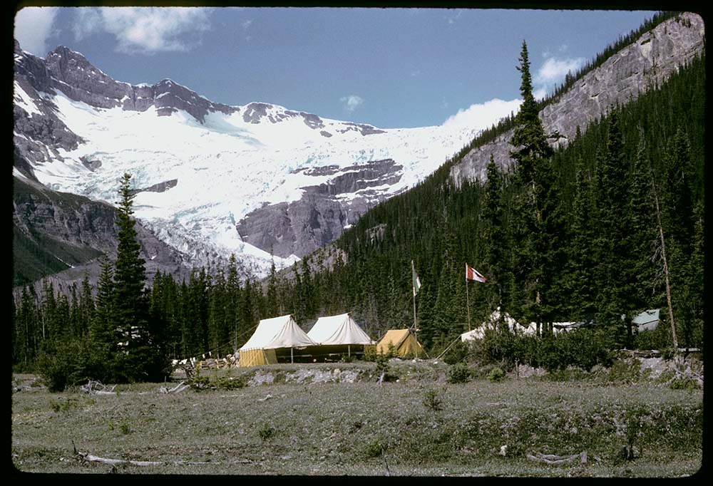
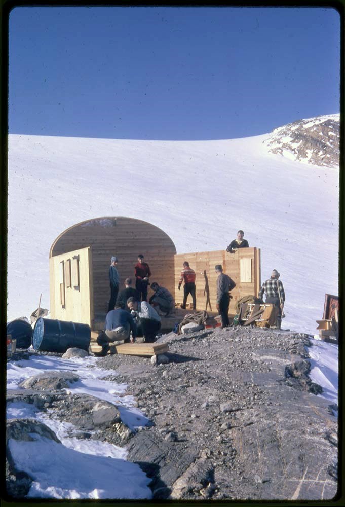
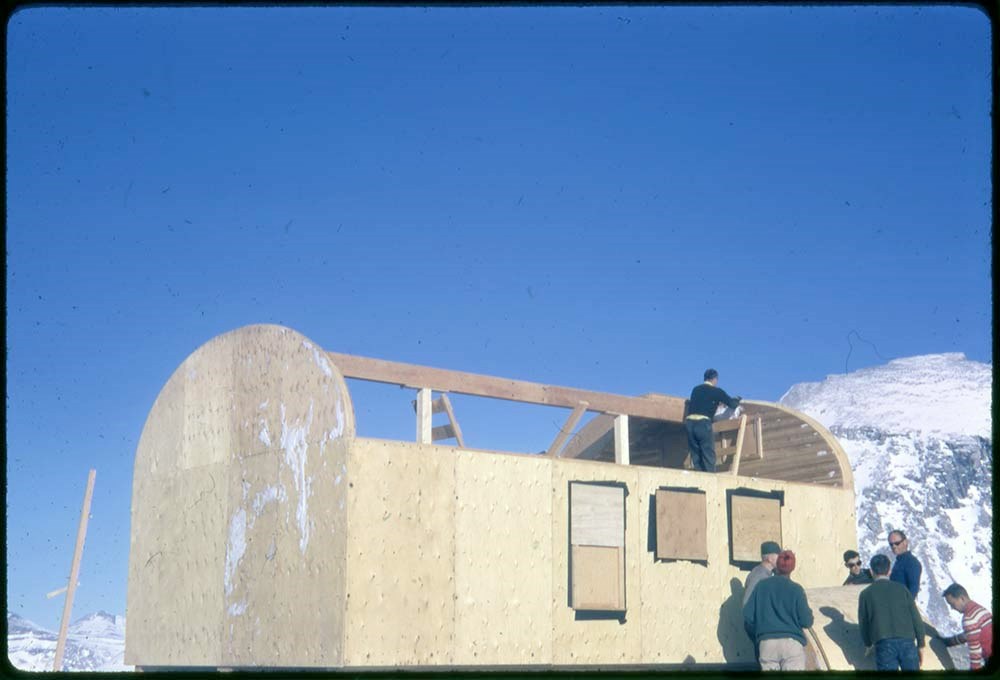
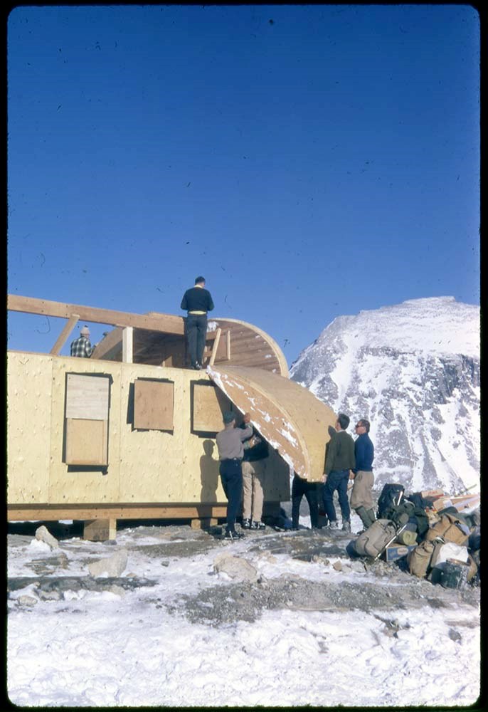
- File pertains to climbing, skiing, ski touring, camps, facilities and landscape views in Banff and Yoho National Parks. Includes the construction of Bow Hut.
- Date Range
- 1944-1990
- Reference Code
- V46 / I / A / 29 / NS - 1 to 493
- Description Level
- 5 / File
- GMD
- Negative
8 images
- Part Of
- Bob Hind fonds
- Description Level
- 5 / File
- Fonds Number
- M7 / V46
- Series
- I.A. Mountain travel and recreation, western Canada : Trips and activities
- Sous-Fonds
- V46
- Accession Number
- 7181
- Reference Code
- V46 / I / A / 29 / NS - 1 to 493
- GMD
- Negative
- Other Title Info
- Alternate title: Banff, Yoho etc from 1950, Gl lake
- Date Range
- 1944-1990
- Physical Description
- 493 photographs : transparencies, 35mm, col
- History / Biographical
- See fonds level description
- Scope & Content
- File pertains to climbing, skiing, ski touring, camps, facilities and landscape views in Banff and Yoho National Parks. Includes the construction of Bow Hut.
- Notes
- LIST OF CONTENTS (V46 / 29 ) :
- * Alta 47, Atha 47 - 1947
- * Landscape/s and hut - 1948
- * M50 : Maligne Lake and camp - 1950
- * SG 51 : glacier, climbing - 1951
- * Mount Hooker area, camps, landscape view/s (S53), climbing - 1953
- * EC55 : Mount Edith Cavell - 1955
- * Moat Lake 57, Athz 57, T57, Eremite 57: landscape view/s, camp, hut - 1957
- * Landscape view/s - 1958
- * Mal62, Maligne 62, Col 62, Colum 62 : landscape view/s, horse trail - 1962
- * Landscape view/s - 1968
- * F76 : flora - 1976
- * Winter landscape view/s and hut - 1978
- Name Access
- Hind, Bob
- Subject Access
- Alpine Club of Canada
- Backcountry skiing
- Buildings and facilities
- Construction
- Exploration
- Glaciers
- Guides
- Guiding
- Geographic Access
- Bow Hut
- Banff National Park
- Yoho National Park
- Alberta
- British Columbia
- Canada
- Language
- NA
- Title Source
- Title based on contents of file
- Content Details
- LIST OF CONTENTS (V46 / 27) :
- * Mountain landscape views - 1947
- * Ski touring, Skoki area; skiing at Mount Norquay - 1948
- * Skiing in Sunshine area - 1949
- * Ski meet : ski meet at Mount Norquay, includes Banff Winter Carnival queen and John Hunter, Stoney First Nation - 1950
- * F50 : Fay Hut, climbing, landscape views. Includes some photographs by MH - 1950
- * KL, KH, Baker, Wapta : Castle Mountain, Wapta cabin and car, landscape views - 1950
- * B51 : Banff Springs Hotel panorama, Cascade of Times garden, bears - 1951
- * S51 : Skoki area, ski touring and landscape views - 1951
- * Cos 51 : wildlife - 1951
- * Y51 : Stanley Mitchell Hut in winter, ski touring group, Yoho area landscape - 1951
- * EIC 51 : landscape views - 1951
- * Hiking in Lake O'Hara area - 1951
- * Sk52 : Skoki area, ski touring and landscape views - 1952
- * Skoki area, Mount Whyte - 1953
- * Banff climbing, landscape views, Lake Louise area, camps, Skoki area, Mount Whyte - 1954
- * Climbing, Skoki Lodge, landscape views - 1955
- * Ski touring, Sunshine area, Mount Temple and Skoki areas, landscape views, Skoki Lodge. Includes label: Class III, Marj Bugler - 1956
- * Mount Cory, climbing and landscape views - 1957
- * Mountain rescue - 1957
- * Banff area, climbing and landscape views - 1958
- * Mount Ishbel, Pilot Mountain, climbing - 1959
- * Ice school, snow school, Banff townsite, Yoho area, climbing Mount Cory, Mount Edith, Mount Ishbel, St. Nic - 1960
- * Skoki : includes Skoki Lodge, ski touring - [1960?]
- * Banff : Vermilion Lakes, Bow Falls, wildlife, Mount Norquay - [1960?]
- * Banff : Banff area, Mount Norquay, chairlift - [ca.1960]
- * Yoho : group at Stanley Mitchell Hut - [ca.1960]
- * Lake Louise - [ca.1960]
- * Emerald : Mount Burgess, Kicking Horse River, ski touring at Sunshine and Mount Temple areas, Mount Norquay ski area, landscape views and people, Peyto Lake, Emerald Lake, Banff-Jasper Highway - [ca.1960]
- * Yoho area, Stanley Mitchell Hut, climber, snowman, climbing Mount Cory, Banff views - 1961
- * Bow Lake - 1962
- * Mount Temple, Banff area - 1963
- * GL recce : Glacier Lake area reconnaissance views, horses and ski touring - 1964
- * Glacier Lake, Alpine Club of Canada camp, botany, glacier climbing - 1965
- * Larch Valley, Moraine Lake, Mount Inglismaldie, Dolomite Peak - 1966
- * Ski touring, Hole-in-the-Wall, landscape, botany - 1967
- * Bow Hut construction, Shadow Lake cabin, children, landscape views - 1968
- * Yoho landscape, Stanley Mitchell Hut, children hiking - 1969
- * Lake O'Hara area - 1969
- * Castleguard Meadows camp, hiking and landscape, Saskatchewan Glacier Hut - 1944-1972
- * Glacier Lake camp (summer), hiking, botany, landscape. Includes competition entries by MGH and RG Hind: Class I, II and IV - 1973
- * Banff area, hiking and landscape, including Heart Mountain, Emerald Lake - 1974
- * Banff Indian Days, Healy Creek - 1975
- * Mountain glacier - 1976
- * Pilot Mountain area (fall/winter) and ski touring; man - 1977
- * Camp (summer), hiking, landscape views - 1978
- * Landscape views, man, woman - 1980
- * Snow crystals, Yoho map - 1981
- * Bow River? view - 1982
- * Cathy wedding; woman at Cascade Mountain - 1983
- * Banff area, Moraine Lake tourist - 1984
- * Man and woman at Castle Mountain - 1987
- * Chateau Lake Louise dinner group - 1990
- Processing Status
- Processed
Images


This material is presented as originally created; it may contain outdated cultural descriptions and
potentially offensive content.
Read more.
Big White Ski Village
https://archives.whyte.org/en/permalink/descriptions54801
- Part Of
- Murray Hay fonds
- Scope & Content
- File consists of 0.5 cm of textual records, 90 x 60.5 cm. File pertains to ski trail maps of Big White Ski Village and Area created by Murray Hay. File includes one oversized published reproduction of a Big White trail map in poster format.
- Date Range
- ca.1980 - ca.2000
- Reference Code
- M570 / III / A / v / 1
- Description Level
- 5 / File
- GMD
- Map
- Poster
- Published record
- Textual record
- Part Of
- Murray Hay fonds
- Description Level
- 5 / File
- Fonds Number
- M570 / V795
- Series
- M570 / III : Murray Hay portfolio (published material)
- Sous-Fonds
- M570
- Sub-Series
- M570 / III / A : British Columbia / v : Big White
- Accession Number
- 2019.41
- Reference Code
- M570 / III / A / v / 1
- Date Range
- ca.1980 - ca.2000
- Physical Description
- 0.5 cm of textual records (90 x 60.5 cm)
- Scope & Content
- File consists of 0.5 cm of textual records, 90 x 60.5 cm. File pertains to ski trail maps of Big White Ski Village and Area created by Murray Hay. File includes one oversized published reproduction of a Big White trail map in poster format.
- Name Access
- Hay, Murray
- Subject Access
- Ski Maps
- Map
- Ski area
- Skiing
- Tourism
- Travel
- Winter
- Winter sports
- Sports and recreation
- Big White Ski Area
- Tourist information
- Artist
- Advertising
- Geographic Access
- Kelowna
- British Columbia
- Canada
- Language
- English
- Related Material
- V795 / II / A / iv / 5
- Title Source
- Title based on contents of file
- Processing Status
- Processed
This material is presented as originally created; it may contain outdated cultural descriptions and
potentially offensive content.
Read more.
Fairmont Hot Springs
https://archives.whyte.org/en/permalink/descriptions54807
- Part Of
- Murray Hay fonds
- Scope & Content
- File consists of 1 cm of textual records, 23 x 30 cm. File pertains to alpine and cross-country ski trail maps at Fairmont Hot Springs created by Murray Hay. File includes a reproduced map of the resort village and ski areas that was included in a bound brochure promoting Vacation Lease Ownership a…
- Date Range
- ca. 1980 - ca. 1990
- Reference Code
- M570 / III / A / vi / 1
- Description Level
- 5 / File
- GMD
- Map
- Textual record
- Published record
- Part Of
- Murray Hay fonds
- Description Level
- 5 / File
- Fonds Number
- M570 / V795
- Series
- M570 / III : Murray Hay portfolio (published material)
- Sous-Fonds
- M570
- Sub-Series
- M570 / III / A : British Columbia / vi : Fairmont Hot Springs
- Accession Number
- 2019.41
- Reference Code
- M570 / III / A / vi / 1
- Date Range
- ca. 1980 - ca. 1990
- Physical Description
- 1 cm of textual records (23 x 30 cm)
- Scope & Content
- File consists of 1 cm of textual records, 23 x 30 cm. File pertains to alpine and cross-country ski trail maps at Fairmont Hot Springs created by Murray Hay. File includes a reproduced map of the resort village and ski areas that was included in a bound brochure promoting Vacation Lease Ownership at the Fairmont Hot Springs Villas.
- Name Access
- Hay, Murray
- Subject Access
- Cartography
- Map
- Ski Maps
- Skiing
- Ski area
- Hot Springs
- Resort
- Winter sports
- Tourism
- Tourist information
- Travel
- Advertising
- Artist
- Geographic Access
- British Columbia
- Canada
- Fairmont Hot Springs
- Language
- English
- Related Material
- V795 / II / A / viii / 1
- Title Source
- Title based on contents of file
- Processing Status
- Processed
This material is presented as originally created; it may contain outdated cultural descriptions and
potentially offensive content.
Read more.
- Part Of
- Murray Hay fonds
- Scope & Content
- File consists of 1 cm of textual records, 21 x 29.5 cm. File pertains to the Alts Ski Area in Japan for which Murray Hay created a trail map. File includes one tourist booklet that includes Hay's trail map.
- Date Range
- ca. 1995
- Reference Code
- M570 / III / D / ii / 2
- Description Level
- 5 / File
- GMD
- Map
- Published record
- Textual record
- Part Of
- Murray Hay fonds
- Description Level
- 5 / File
- Fonds Number
- M570 / V795
- Series
- M570 / III : Murray Hay portfolio (published material)
- Sous-Fonds
- M570
- Sub-Series
- M570 / III / D : Miscellaneous / ii : International
- Accession Number
- 2019.41
- Reference Code
- M570 / III / D / ii / 2
- Date Range
- ca. 1995
- Physical Description
- 1 cm of textual records (21 x 29.5 cm)
- Scope & Content
- File consists of 1 cm of textual records, 21 x 29.5 cm. File pertains to the Alts Ski Area in Japan for which Murray Hay created a trail map. File includes one tourist booklet that includes Hay's trail map.
- Notes
- The booklet is in Japanese.
- Name Access
- Hay, Murray
- Subject Access
- Advertising
- Artist
- Ski Maps
- Ski area
- Skiing
- Cartography
- Map
- Sports and recreation
- Tourism
- Tourist information
- Travel
- Winter
- Winter sports
- Geographic Access
- Japan
- Language
- Japanese
- English
- Related Material
- V795 / II / D / ii / 1
- Title Source
- Title based on contents of file
- Processing Status
- Processed
This material is presented as originally created; it may contain outdated cultural descriptions and
potentially offensive content.
Read more.
Kananaskis and Spray Lakes
https://archives.whyte.org/en/permalink/descriptions54802
- Part Of
- Murray Hay fonds
- Scope & Content
- File consists of 1.5 cm of textual records, 35 x 35 cm or smaller. File pertains to travel and tourism materials related to the Kananaskis-Canmore area. File includes four published Murray Hay trail maps of ski hills in Kananaskis (Nakiska, Fortress, Mount Allan) and a travel brochure relating to t…
- Date Range
- 1978 - ca.1995
- 1988
- 1978-1979
- Reference Code
- M570 / III / B / iv / 1-2
- Description Level
- 5 / File
- GMD
- Map
- Published record
- Textual record
- Poster
- Part Of
- Murray Hay fonds
- Description Level
- 5 / File
- Fonds Number
- M570 / V795
- Series
- M570 / III : Murray Hay portfolio (published material)
- Sous-Fonds
- M570
- Sub-Series
- M570 / III / B : Alberta / iv : Kananaskis
- Accession Number
- 2019.41
- Reference Code
- M570 / III / B / iv / 1-2
- Date Range
- 1978 - ca.1995
- 1988
- 1978-1979
- Physical Description
- 1.5 cm of textual records (35 x 35 cm or smaller)
- Scope & Content
- File consists of 1.5 cm of textual records, 35 x 35 cm or smaller. File pertains to travel and tourism materials related to the Kananaskis-Canmore area. File includes four published Murray Hay trail maps of ski hills in Kananaskis (Nakiska, Fortress, Mount Allan) and a travel brochure relating to the Kananaskis and Canmore area. The Mount Allan maps include recreational ski runs and Olympic ski runs.
- Notes
- M570 / III / B / iv / 2 is oversize.
- Name Access
- Hay, Murray
- Subject Access
- Ski area
- Ski Maps
- Skiing
- Cartography
- Map
- Tourism
- Travel
- Winter
- Winter sports
- Nakiska Ski Area
- Fortress Mountain
- Mount Allan
- Tourist information
- Artist
- Advertising
- Geographic Access
- Kananaskis
- Spray Valley
- Alberta
- Canada
- Canmore
- Language
- English
- Title Source
- Title based on contents of file
- Processing Status
- Processed
This material is presented as originally created; it may contain outdated cultural descriptions and
potentially offensive content.
Read more.
- Part Of
- Murray Hay fonds
- Scope & Content
- File consists of 1.5 cm of textual records, 53 x 80.5 cm and 10 x 23.5 cm. File pertains to ski trail maps of Lake Louise ski area created by Murray Hay. File includes two published reproductions of three original trail maps in a fold-out brochure (1992/1993) and in poster format. The three maps de…
- Date Range
- ca.1980 - ca. 1995
- 1992-1993
- Reference Code
- M570 / III / B / ii / 1-2
- Description Level
- 5 / File
- GMD
- Textual record
- Published record
- Map
- Poster
- Part Of
- Murray Hay fonds
- Description Level
- 5 / File
- Fonds Number
- M570 / V795
- Series
- M570 / III : Murray Hay portfolio (published material)
- Sous-Fonds
- M570
- Sub-Series
- M570 / III / B : Alberta / ii : Lake Louise
- Accession Number
- 2019.41
- Reference Code
- M570 / III / B / ii / 1-2
- Date Range
- ca.1980 - ca. 1995
- 1992-1993
- Physical Description
- 1.5 cm of textual records (53 x 80.5 cm and 10 x 23.5 cm)
- Scope & Content
- File consists of 1.5 cm of textual records, 53 x 80.5 cm and 10 x 23.5 cm. File pertains to ski trail maps of Lake Louise ski area created by Murray Hay. File includes two published reproductions of three original trail maps in a fold-out brochure (1992/1993) and in poster format. The three maps depict South Face, Back Bowls, and Larch Area.
- Name Access
- Hay, Murray
- Subject Access
- Ski area
- Ski Maps
- Skiing
- Tourism
- Cartography
- Map
- Winter
- Winter sports
- Sports and recreation
- Travel
- Lake Louise Ski Area
- Lake Louise
- Artist
- Advertising
- Geographic Access
- Lake Louise
- Alberta
- Canada
- Canadian Rocky Mountains
- Language
- English
- Related Material
- V795 / II / B / ii / 1
- Title Source
- Title based on contents of file
- Processing Status
- Processed
This material is presented as originally created; it may contain outdated cultural descriptions and
potentially offensive content.
Read more.
- Part Of
- Murray Hay fonds
- Scope & Content
- File consists of 5 prints : b&w and col. ; 38 x 26.5 cm or smaller. FIle pertains to Murray Hay's work on different maps for a variety of places in British Columbia, Canada. File includes three draft prints of different iterations of the ski trails at the Fairmont Hot Springs resort; a map labelled…
- Date Range
- ca.1976-ca.2000
- Reference Code
- V795 / II / A / viii / 1-3
- Description Level
- 5 / File
- GMD
- Private record
- Map
- Part Of
- Murray Hay fonds
- Description Level
- 5 / File
- Fonds Number
- M570 / V795
- Series
- V795 / II : Unpublished Material
- Sous-Fonds
- V795
- Sub-Series
- V795 / II / A : British Columbia / viii : Miscellaneous
- Accession Number
- 2019.41
- Reference Code
- V795 / II / A / viii / 1-3
- GMD
- Private record
- Map
- Date Range
- ca.1976-ca.2000
- Physical Description
- 5 prints : b&w and col. ; 38 x 26.5 cm or smaller
- Scope & Content
- File consists of 5 prints : b&w and col. ; 38 x 26.5 cm or smaller. FIle pertains to Murray Hay's work on different maps for a variety of places in British Columbia, Canada. File includes three draft prints of different iterations of the ski trails at the Fairmont Hot Springs resort; a map labelled in pencil (on the back of the print) "Cypress Bowl Cross Country Ski Map - Vancouver", and a map glued or otherwise attached to a piece of white board labelled in blue ink "Blue River Heli Ski Area (approximately the size of Belgium."
- Name Access
- Hay, Murray
- Subject Access
- Advertising
- Artist
- Ski area
- Ski Maps
- Map
- Cartography
- Sports and recreation
- Tourism
- Tourist information
- Helicopter skiing
- Winter
- Winter sports
- Geographic Access
- Vancouver
- Fairmont Hot Springs
- Blue River Resort
- British Columbia
- Canada
- Language
- English
- Conservation
- Adhesives should be removed and alternative preservation methods should be used.
- Related Material
- M570 / III / A / vi / 1
- Creator
- Hay, Murray
- Title Source
- Title based on contents of file
- Processing Status
- Processed
This material is presented as originally created; it may contain outdated cultural descriptions and
potentially offensive content.
Read more.
Newspaper Clippings
https://archives.whyte.org/en/permalink/descriptions54745
- Part Of
- Murray Hay fonds
- Scope & Content
- File consists of 1 cm of textual material in the form of newspaper clippings, 32 x 60 cm or smaller. File pertains to the career of Murray Hay as a ski map artist. File documents Hay's wide-ranging success creating trail maps for ski resorts, particularly in Alberta and British Columbia, Canada (al…
- Date Range
- 1991
- 1993
- 1996
- 1998
- Reference Code
- M570 / I / 1
- Description Level
- 5 / File
- GMD
- Published record
- Textual record
- Newspaper clipping
- Part Of
- Murray Hay fonds
- Description Level
- 5 / File
- Fonds Number
- M570 / V795
- Series
- M570 / I : Newspaper Clippings
- Sous-Fonds
- M570
- Accession Number
- 2019.41
- Reference Code
- M570 / I / 1
- Date Range
- 1991
- 1993
- 1996
- 1998
- Physical Description
- 1 cm of textual records (32 x 60 cm or smaller)
- Scope & Content
- File consists of 1 cm of textual material in the form of newspaper clippings, 32 x 60 cm or smaller. File pertains to the career of Murray Hay as a ski map artist. File documents Hay's wide-ranging success creating trail maps for ski resorts, particularly in Alberta and British Columbia, Canada (although he made maps for ski resorts and other organizations internationally, particularly in the United States). File also includes interviews with Hay about his mapmaking process and style, successes, challenges (including the impact of technology on his work).
- 2020-02-14
- Notes
- Includes articles that were published in the Calgary Sun (January 17, 1991) and the Calgary Herald (March 11, 1993; March 2, 1996; April 16, 1998).
- Name Access
- Hay, Murray
- Subject Access
- Ski areas
- Skiing
- Sports and recreation
- Art
- Artist
- Map
- Ski Maps
- Activities
- Banff National Park
- Cartography
- Lake Louise Ski Area
- Landscapes
- Professional and Personal Life
- Winter
- Winter sports
- Whistler Blackcomb
- Newspaper
- Calgary Herald
- Calgary Sun
- Geographic Access
- Canada
- Canadian Rocky Mountains
- Alberta
- Banff National Park
- Jasper National Park
- British Columbia
- Calgary
- Language
- English
- Title Source
- Title based on contents of file
- Processing Status
- Processed
This material is presented as originally created; it may contain outdated cultural descriptions and
potentially offensive content.
Read more.
- Part Of
- Murray Hay fonds
- Scope & Content
- File consists of 2.5 cm of textual records, 90 x 60 cm or smaller. File includes reproduced maps originally created by Murray Hay that depict the Panorama ski area in British Columbia, Canada: M570 / III / A / iii / 1 : Includes brochures and booklets for the Panorama Ski Resort. M570 / III / A /…
- Date Range
- ca.1975-ca.1995
- Reference Code
- M570 / III / A / iii / 1-2
- Description Level
- 5 / File
- GMD
- Map
- Poster
- Published record
- Textual record
- Part Of
- Murray Hay fonds
- Description Level
- 5 / File
- Fonds Number
- M570 / V795
- Series
- M570 / III : Murray Hay Portfolio (published material)
- Sous-Fonds
- M570
- Sub-Series
- M570 / III / A : British Columbia / iii : Panorama
- Accession Number
- 2019.41
- Reference Code
- M570 / III / A / iii / 1-2
- Date Range
- ca.1975-ca.1995
- Physical Description
- 2.5 cm of textual records (90 x 60 cm or smaller)
- Scope & Content
- File consists of 2.5 cm of textual records, 90 x 60 cm or smaller. File includes reproduced maps originally created by Murray Hay that depict the Panorama ski area in British Columbia, Canada:
- M570 / III / A / iii / 1 : Includes brochures and booklets for the Panorama Ski Resort.
- M570 / III / A / iii / 2 : Poster of the Panorama Heli-Skiing area.
- Notes
- M570 / III / A / iii / 2 is oversize.
- Items do not include dates. The approximate date range was chosen based on the history of the development of heli-skiing in Panorama (https://www.rkheliski.com/galleries/rk-heliski-history) and the history of the Panorama Ski Resort (it was purchased by Intrawest in 1993, https://www.panoramaresort.com/planning/history-of-panorama/).
- Name Access
- Hay, Murray
- Subject Access
- Skiing
- Ski areas
- Ski Maps
- Helicopter skiing
- Sports and recreation
- Cartography
- Tourism
- Tourist information
- Winter
- Winter sports
- Advertising
- Artist
- Geographic Access
- British Columbia
- Purcell Mountains
- Panorama
- Canada
- Language
- English
- Title Source
- Title based on contents of file
- Processing Status
- Processed
This material is presented as originally created; it may contain outdated cultural descriptions and
potentially offensive content.
Read more.
Panorama Mountain Resort & Heli-Ski Area
https://archives.whyte.org/en/permalink/descriptions54884
- Part Of
- Murray Hay fonds
- Scope & Content
- File consists of 3 prints : col. ; 35 x 35 cm and 35 x 28 cm. File pertains to Murray Hay's various renderings of the Panorama ski and heli-ski areas in Invermere, British Columbia. File includes two reproduced draft prints of the Panorama Heli-Ski Area and one reproduced draft print of the Panoram…
- Date Range
- ca.1976-ca.2000
- Reference Code
- V795 / II / A / vii / 1
- Description Level
- 5 / File
- GMD
- Map
- Private record
- Part Of
- Murray Hay fonds
- Description Level
- 5 / File
- Fonds Number
- M570 / V795
- Series
- V795 / II : Unpublished Material
- Sous-Fonds
- V795
- Sub-Series
- V795 / II / A : British Columbia / vii : Invermere
- Accession Number
- 2019.41
- Reference Code
- V795 / II / A / vii / 1
- GMD
- Map
- Private record
- Date Range
- ca.1976-ca.2000
- Physical Description
- 3 prints : col. ; 35 x 35 cm and 35 x 28 cm
- Scope & Content
- File consists of 3 prints : col. ; 35 x 35 cm and 35 x 28 cm. File pertains to Murray Hay's various renderings of the Panorama ski and heli-ski areas in Invermere, British Columbia. File includes two reproduced draft prints of the Panorama Heli-Ski Area and one reproduced draft print of the Panorama Ski Area (each print is labelled in ink).
- Name Access
- Hay, Murray
- Subject Access
- Art
- Artist
- Ski Maps
- Map
- Cartography
- Sports and recreation
- Tourism
- Tourist information
- Helicopter skiing
- Winter
- Winter sports
- Ski area
- Geographic Access
- Panorama
- British Columbia
- Canada
- Invermere
- Language
- English
- Related Material
- M570 / III / A / iii / 1-2
- Creator
- Hay, Murray
- Title Source
- Title based on contents of file
- Processing Status
- Processed
This material is presented as originally created; it may contain outdated cultural descriptions and
potentially offensive content.
Read more.