Narrow Results By
- Peter Whyte (1905 – 1966, Canadian) 8
- Catharine Robb Whyte, O. C. (1906 – 1979, Canadian) 6
- Carl Clemens Moritz Rungius (1869 – 1959, American) 2
- Duncan Darroch (1888 – 1967, New Zealander) 1
- Kenneth Keith Forbes (1892 – 1980, Canadian) 1
- Michael Cameron (1955 – , Canadian) 1
- William Hutchinson (1874 – 1918, Canadian) 1
[Christian Valley 82E/10 B.C.]
https://archives.whyte.org/en/permalink/catalogue23554
- Medium
- Library - Maps and blueprints (unannotated; published)
- Map
- Published Date
- 1968
- Publisher
- Department of Energy, Mines and Resources
- Call Number
- NTS
- 82E/10
- Publisher
- Department of Energy, Mines and Resources
- Published Date
- 1968
- Physical Description
- 1 map : col
- Scale
- Scale: 1:50,000
- Relief: Contour interval 100 ft.
- Subjects
- Christian Valley
- British Columbia
- Notes
- National Topographic System
- Accession Number
- 7000
- Call Number
- NTS
- 82E/10
- Collection
- Archives Library
This material is presented as originally created; it may contain outdated cultural descriptions and
potentially offensive content.
Read more.
[Deep Valley Creek South, Alberta]
https://archives.whyte.org/en/permalink/catalogue23579
- Medium
- Library - Maps and blueprints (unannotated; published)
- Map
- Published Date
- 1947
- Publisher
- Dept. of Mines & Technical Survey
- Call Number
- NTS
- 82K/4E
- Publisher
- Dept. of Mines & Technical Survey
- Published Date
- 1947
- Scale
- Scale: 1:50,000
- Subjects
- Deep Valley Creek
- Alberta
- Notes
- National Topographic System
- Accession Number
- 12000
- Call Number
- NTS
- 82K/4E
- Collection
- Archives Library
This material is presented as originally created; it may contain outdated cultural descriptions and
potentially offensive content.
Read more.
[Deep Valley Creek South, Alberta]
https://archives.whyte.org/en/permalink/catalogue23580
- Medium
- Library - Maps and blueprints (unannotated; published)
- Map
- Published Date
- 1947
- Publisher
- Dept. of Mines & Technical Survey
- Call Number
- NTS
- 83K/4W
- Publisher
- Dept. of Mines & Technical Survey
- Published Date
- 1947
- Scale
- Scale: 1:50,000
- Subjects
- Deep Valley Creek
- Alberta
- Notes
- National Topographic System
- Accession Number
- 12000
- Call Number
- NTS
- 83K/4W
- Collection
- Archives Library
This material is presented as originally created; it may contain outdated cultural descriptions and
potentially offensive content.
Read more.
[Photostat map of Kananaskis region]
https://archives.whyte.org/en/permalink/catalogue24799
- Medium
- Library - Maps and blueprints (unannotated; published)
- Map
- Published Date
- 1908
- Publisher
- [Ottawa : Dept. of the Interior?]
- Call Number
- C12-1.30
- Publisher
- [Ottawa : Dept. of the Interior?]
- Published Date
- 1908
- Physical Description
- 1 map : photostat
- Scale
- 1 inch = 3 miles
- Subjects
- Kananaskis Valley
- Notes
- Signed T.J.K.
- Shows coal leases, quarries and mineral applications
- Photostat from National Map Collection, Public Archives Canada, 1968
- Call Number
- C12-1.30
- Collection
- Archives Library
This material is presented as originally created; it may contain outdated cultural descriptions and
potentially offensive content.
Read more.
Sketch map showing roads and trails
https://archives.whyte.org/en/permalink/catalogue21356
- Medium
- Library - Maps and blueprints (unannotated; published)
- Map
- Published Date
- 1960's
- Call Number
- C6-4.4(c)
- Published Date
- 1960's
- Subjects
- Yoho Valley and Emerald Lake Area
- Notes
- Information on reverse side of map
- Accession Number
- 1105
- Call Number
- C6-4.4(c)
- Collection
- Archives Library
This material is presented as originally created; it may contain outdated cultural descriptions and
potentially offensive content.
Read more.
Sketch map showing roads and trails
https://archives.whyte.org/en/permalink/catalogue21386
- Medium
- Library - Maps and blueprints (unannotated; published)
- Map
- Published Date
- 1960's
- Call Number
- C6-4.4(c)
- Published Date
- 1960's
- Subjects
- Yoho Valley and Emerald Lake Area
- Notes
- Information on reverse side of map
- Accession Number
- 1105
- Call Number
- C6-4.4(c)
- Collection
- Archives Library
This material is presented as originally created; it may contain outdated cultural descriptions and
potentially offensive content.
Read more.
- Date
- 2004
- Medium
- oil; tar; varnish on board
- Catalogue Number
- CaM.02.08
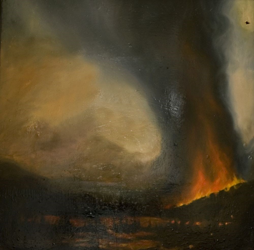
- Description
- 2003 forest fire in Skoki Valley.
1 image
- Title
- Valley Fire
- Date
- 2004
- Medium
- oil; tar; varnish on board
- Dimensions
- 76.0 x 76.0 cm
- Description
- 2003 forest fire in Skoki Valley.
- Credit
- Gift of Michael Cameron, Banff, 2004
- Catalogue Number
- CaM.02.08
Images
This material is presented as originally created; it may contain outdated cultural descriptions and
potentially offensive content.
Read more.
- Date
- n.d.
- Medium
- oil on canvas
- Catalogue Number
- DaD.02.04
- Description
- White, blue and greens. Green valley dipping to bottom middle of the paintings, large white unidentified mountain peaking middle top of image with light blue sky.
1 image
- Title
- Untitled
- Date
- n.d.
- Medium
- oil on canvas
- Dimensions
- 34.5 x 39.5 cm
- Description
- White, blue and greens. Green valley dipping to bottom middle of the paintings, large white unidentified mountain peaking middle top of image with light blue sky.
- Credit
- Gift of Aileen Harmon (Estate), Mill Bay, 2016
- Catalogue Number
- DaD.02.04
Images

This material is presented as originally created; it may contain outdated cultural descriptions and
potentially offensive content.
Read more.
Valley of the Ten Peaks
https://archives.whyte.org/en/permalink/artifactfok.02.01
- Date
- 1931
- Medium
- oil on canvas
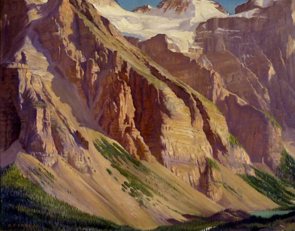
- Catalogue Number
- FoK.02.01
- Description
- General colour: tans, purples. There is a glacier at the center top of the canvas. A lake in the bottom right corner. Scree and trees fill lower third. Two bits of sky at the top. Major pat of the canvas is rock face of the mountain.
1 image
- Title
- Valley of the Ten Peaks
- Date
- 1931
- Medium
- oil on canvas
- Dimensions
- 46.9 x 59.9 cm
- Description
- General colour: tans, purples. There is a glacier at the center top of the canvas. A lake in the bottom right corner. Scree and trees fill lower third. Two bits of sky at the top. Major pat of the canvas is rock face of the mountain.
- Credit
- Purchased from Christie's of Canada, Toronto, 1970
- Catalogue Number
- FoK.02.01
Images
This material is presented as originally created; it may contain outdated cultural descriptions and
potentially offensive content.
Read more.
Athabasca Valley and River, B.C.
https://archives.whyte.org/en/permalink/artifacthuw.02.03
- Date
- 1914
- Medium
- oil on paperboard
- Catalogue Number
- HuW.02.03
- Description
- Mountain range dominates top half of the picture, small glacier on one mountain. Foreground is a dark blue river with white currents. Forest at centre right and centre left. Yellow tinged river valley.
- Title
- Athabasca Valley and River, B.C.
- Date
- 1914
- Medium
- oil on paperboard
- Dimensions
- 90.6 x 103.5 cm
- Description
- Mountain range dominates top half of the picture, small glacier on one mountain. Foreground is a dark blue river with white currents. Forest at centre right and centre left. Yellow tinged river valley.
- Subject
- landscape
- Canadian Rockies
- river
- valley
- Athabasca
- Credit
- Gift of Dorothy Hutchinson, Winnipeg, 1994
- Catalogue Number
- HuW.02.03
This material is presented as originally created; it may contain outdated cultural descriptions and
potentially offensive content.
Read more.