Narrow Results By
[Christian Valley 82E/10 B.C.]
https://archives.whyte.org/en/permalink/catalogue23554
- Medium
- Library - Maps and blueprints (unannotated; published)
- Map
- Published Date
- 1968
- Publisher
- Department of Energy, Mines and Resources
- Call Number
- NTS
- 82E/10
- Publisher
- Department of Energy, Mines and Resources
- Published Date
- 1968
- Physical Description
- 1 map : col
- Scale
- Scale: 1:50,000
- Relief: Contour interval 100 ft.
- Subjects
- Christian Valley
- British Columbia
- Notes
- National Topographic System
- Accession Number
- 7000
- Call Number
- NTS
- 82E/10
- Collection
- Archives Library
This material is presented as originally created; it may contain outdated cultural descriptions and
potentially offensive content.
Read more.
[Deep Valley Creek South, Alberta]
https://archives.whyte.org/en/permalink/catalogue23579
- Medium
- Library - Maps and blueprints (unannotated; published)
- Map
- Published Date
- 1947
- Publisher
- Dept. of Mines & Technical Survey
- Call Number
- NTS
- 82K/4E
- Publisher
- Dept. of Mines & Technical Survey
- Published Date
- 1947
- Scale
- Scale: 1:50,000
- Subjects
- Deep Valley Creek
- Alberta
- Notes
- National Topographic System
- Accession Number
- 12000
- Call Number
- NTS
- 82K/4E
- Collection
- Archives Library
This material is presented as originally created; it may contain outdated cultural descriptions and
potentially offensive content.
Read more.
[Deep Valley Creek South, Alberta]
https://archives.whyte.org/en/permalink/catalogue23580
- Medium
- Library - Maps and blueprints (unannotated; published)
- Map
- Published Date
- 1947
- Publisher
- Dept. of Mines & Technical Survey
- Call Number
- NTS
- 83K/4W
- Publisher
- Dept. of Mines & Technical Survey
- Published Date
- 1947
- Scale
- Scale: 1:50,000
- Subjects
- Deep Valley Creek
- Alberta
- Notes
- National Topographic System
- Accession Number
- 12000
- Call Number
- NTS
- 83K/4W
- Collection
- Archives Library
This material is presented as originally created; it may contain outdated cultural descriptions and
potentially offensive content.
Read more.
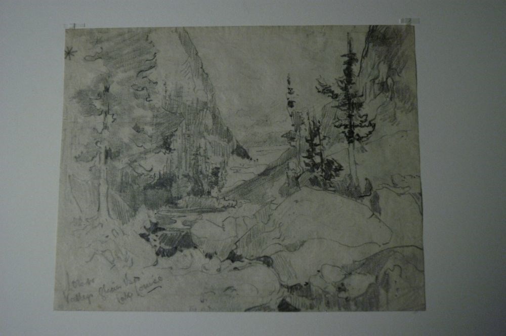
Lower Valleys Glacier Bed, Lake Louise
https://archives.whyte.org/en/permalink/artifactcoj.03.233
- Date
- c. 1920
- Medium
- graphite on paper
- Catalogue Number
- CoJ.03.233
- Description
- Valley area centre with mountains on either side, rocks in foreground right, four trees on mountain side right, one large tree on same plane as other trees left, mountains from a V in distance, valley continues at the base of the V.“Sketching Lake Louise was de rigour for artists in Canada in the f…
1 image
- Title
- Lower Valleys Glacier Bed, Lake Louise
- Date
- c. 1920
- Medium
- graphite on paper
- Dimensions
- 19.8 x 25.7 cm
- Description
- Valley area centre with mountains on either side, rocks in foreground right, four trees on mountain side right, one large tree on same plane as other trees left, mountains from a V in distance, valley continues at the base of the V.“Sketching Lake Louise was de rigour for artists in Canada in the first decades of the twentieth century. Collings chose an unusual view looking down towards the lake through a narrow, sinuous valley. The resulting “starburst” composition is contained by uncompromisingly vertical trees on either side.” -- “Charles John Collings, 1848-1931” Catalogue Raisonne by Linda Heath
- Subject
- landscape
- Lake Louise
- trees
- valley
- Credit
- Gift of John Rivette, Seymour Arm, 1983
- Catalogue Number
- CoJ.03.233
Images
This material is presented as originally created; it may contain outdated cultural descriptions and
potentially offensive content.
Read more.
- Date
- 1954
- Medium
- graphite on paper
- Catalogue Number
- GoE.03.03
- Description
- Realistic sketch of Moraine Lake and the Valley of the Ten Peaks.
- Title
- Moraine Lake
- Date
- 1954
- Medium
- graphite on paper
- Dimensions
- 17.5 x 23.5 cm
- Description
- Realistic sketch of Moraine Lake and the Valley of the Ten Peaks.
- Credit
- Gift of Catharine Robb Whyte, O. C., Banff, 1975
- Catalogue Number
- GoE.03.03
This material is presented as originally created; it may contain outdated cultural descriptions and
potentially offensive content.
Read more.
[Photostat map of Kananaskis region]
https://archives.whyte.org/en/permalink/catalogue24799
- Medium
- Library - Maps and blueprints (unannotated; published)
- Map
- Published Date
- 1908
- Publisher
- [Ottawa : Dept. of the Interior?]
- Call Number
- C12-1.30
- Publisher
- [Ottawa : Dept. of the Interior?]
- Published Date
- 1908
- Physical Description
- 1 map : photostat
- Scale
- 1 inch = 3 miles
- Subjects
- Kananaskis Valley
- Notes
- Signed T.J.K.
- Shows coal leases, quarries and mineral applications
- Photostat from National Map Collection, Public Archives Canada, 1968
- Call Number
- C12-1.30
- Collection
- Archives Library
This material is presented as originally created; it may contain outdated cultural descriptions and
potentially offensive content.
Read more.
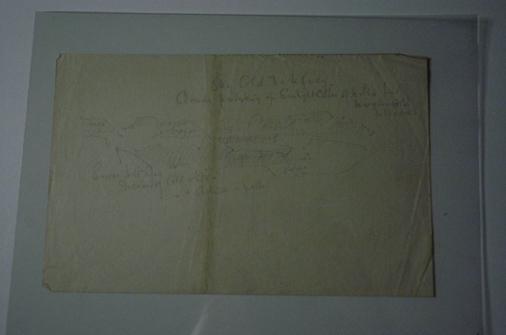
Rough Hillscape
https://archives.whyte.org/en/permalink/artifactcoj.03.530
- Date
- c. 1920
- Medium
- graphite on paper
- Catalogue Number
- CoJ.03.530
- Description
- A faint and rough sketch of hills and valley appears in middle of page. Above and below this sketch, there is writing that denotes colour scheme and details.
1 image
- Title
- Rough Hillscape
- Date
- c. 1920
- Medium
- graphite on paper
- Dimensions
- 16.5 x 25.0 cm
- Description
- A faint and rough sketch of hills and valley appears in middle of page. Above and below this sketch, there is writing that denotes colour scheme and details.
- Credit
- Gift of John Rivette, Seymour Arm, 1997
- Catalogue Number
- CoJ.03.530
Images
This material is presented as originally created; it may contain outdated cultural descriptions and
potentially offensive content.
Read more.
Sketch map showing roads and trails
https://archives.whyte.org/en/permalink/catalogue21356
- Medium
- Library - Maps and blueprints (unannotated; published)
- Map
- Published Date
- 1960's
- Call Number
- C6-4.4(c)
- Published Date
- 1960's
- Subjects
- Yoho Valley and Emerald Lake Area
- Notes
- Information on reverse side of map
- Accession Number
- 1105
- Call Number
- C6-4.4(c)
- Collection
- Archives Library
This material is presented as originally created; it may contain outdated cultural descriptions and
potentially offensive content.
Read more.
Sketch map showing roads and trails
https://archives.whyte.org/en/permalink/catalogue21386
- Medium
- Library - Maps and blueprints (unannotated; published)
- Map
- Published Date
- 1960's
- Call Number
- C6-4.4(c)
- Published Date
- 1960's
- Subjects
- Yoho Valley and Emerald Lake Area
- Notes
- Information on reverse side of map
- Accession Number
- 1105
- Call Number
- C6-4.4(c)
- Collection
- Archives Library
This material is presented as originally created; it may contain outdated cultural descriptions and
potentially offensive content.
Read more.