Narrow Results By
1964 ski trip, skiing with friends
https://archives.whyte.org/en/permalink/descriptions55310
- Part Of
- Chic Scott fonds
- Scope & Content
- File consists of photographs pertaining to Hans Gmoser skiing with friends. Most photographs are from a 1964 ski trip between Toby Creek and the Bugaboos mountain range in British Columbia.
- Date Range
- 1964
- [1980 - 1990]
- Reference Code
- V40 / V / PA - 1 to 24
- Description Level
- 5 / File
- Part Of
- Chic Scott fonds
- Description Level
- 5 / File
- Fonds Number
- M57
- S47
- V40
- Series
- V40 / V : Deep Powder and Steep Rock
- Sous-Fonds
- V40
- Accession Number
- 2015.8559
- Reference Code
- V40 / V / PA - 1 to 24
- Date Range
- 1964
- [1980 - 1990]
- Physical Description
- 24 photographs : b&w and col. prints; 25 x 20 cm or smaller
- Scope & Content
- File consists of photographs pertaining to Hans Gmoser skiing with friends. Most photographs are from a 1964 ski trip between Toby Creek and the Bugaboos mountain range in British Columbia.
- Notes
- Photographs in file are accompanied by one page of handwritten notes pertaining to details of images from 1964 ski trip [PA - 1 to 21] and one copy of an Eaton's newspaper ad featuring an illustration of a ski jumper
- Name Access
- Gmoser, Hans
- McConkey, Jim
- Wiegele, Mike
- Grillmair, Leo
- Gertsch, Rudy
- Gmoser, Margaret
- Lemire, Pierre
- Subject Access
- Sports
- Recreation
- Skiing
- Ski jumping
- Mountains
- Landscapes
- Family and personal life
- Exploration
- Travel
- Winter
- Winter sports
- Geographic Access
- Canada
- British Columbia
- Toby Creek
- Bugaboos
- Canadian Rocky Mountains
- Reproduction Restrictions
- Restrictions may apply
- Language
- English
- Title Source
- Title based on contents of file
- Processing Status
- Processed
This material is presented as originally created; it may contain outdated cultural descriptions and
potentially offensive content.
Read more.
- Part Of
- Murray Hay fonds
- Scope & Content
- File consists of 144 photographs : col. negatives ; 35 m m; 12 prints : col. ; 42 x 35 cm or smaller ; 1 cm of visual material. File pertains to various projects Murray Hay was involved with related to Alaska, USA, particularly in the mid-1990s. File includes: aerial photographs of the landscape (A…
- Date Range
- ca.1990-ca.1999
- 1992
- 1994
- Reference Code
- V795 / II / D / i / 1-2
- Description Level
- 5 / File
- GMD
- Drawing
- Map
- Photograph print
- Negative
- Private record
- Textual record
- Part Of
- Murray Hay fonds
- Description Level
- 5 / File
- Fonds Number
- M570 / V795
- Series
- V795 / II : Unpublished Material
- Sous-Fonds
- V795
- Sub-Series
- V795 / II / D : International / i : United States of America
- Accession Number
- 2019.41
- Reference Code
- V795 / II / D / i / 1-2
- Date Range
- ca.1990-ca.1999
- 1992
- 1994
- Physical Description
- 144 photographs : col. negatives ; 35 mm
- 12 prints : col. ; 42 x 35 cm or smaller
- 1 cm of visual material
- Scope & Content
- File consists of 144 photographs : col. negatives ; 35 m m; 12 prints : col. ; 42 x 35 cm or smaller ; 1 cm of visual material. File pertains to various projects Murray Hay was involved with related to Alaska, USA, particularly in the mid-1990s. File includes: aerial photographs of the landscape (Anchorage area, Homer, Prince William Sound, Valdez); hand-drawn draft maps of the Prince William Sound region (created for a cruise line); a variety of printed maps with annotations demonstrating comments (including a fax with an attached map from Dana at Adventure Media International); and a variety of printed reproductions of draft maps (Alyeska Ski Resort, City of Anchorage for the 1992 Olympic Bid, and Glacier Bay and the Tongass National Forest).
- Notes
- Items not in oversize (negatives) stored in downstairs vault.
- Name Access
- Hay, Murray
- Subject Access
- Advertising
- Artist
- Ski Maps
- Map
- Cartography
- Sports and recreation
- Tourism
- Tourist information
- Travel
- Geography
- Winter
- Winter sports
- Ski area
- Olympic Games (Winter)
- Geographic Access
- Alaska
- United States
- Valdez
- Prince William Sound
- Anchorage
- Glacier Bay and Tongass National Forest
- Language
- English
- Conservation
- Masking tape should be removed and alternative preservation methods used in the future.
- Related Material
- M570 / IV / A / 2-3
- Creator
- Hay, Murray
- Title Source
- Title based on contents of file
- Processing Status
- Processed
This material is presented as originally created; it may contain outdated cultural descriptions and
potentially offensive content.
Read more.
- Part Of
- Murray Hay fonds
- Scope & Content
- File consists of 2 cm of textual records, 43 x 28 cm, or smaller. File pertains to Murray Hay's work on various projects in Alaska, USA, specifically the Mount Roberts Tramway in Juneau and Anchorage's Olympic Bid for the 1992 Winter Olympics. File includes a map and/or illustration of the Mount Ro…
- Date Range
- ca.1980-1997
- 1996
- 1997
- Reference Code
- M570 / IV / A / 2-3
- Description Level
- 5 / File
- GMD
- Textual record
- Private record
- Map
- Part Of
- Murray Hay fonds
- Description Level
- 5 / File
- Fonds Number
- M570 / V795
- Series
- M570 / IV : Murray Hay Personal Papers
- Sous-Fonds
- M570
- Sub-Series
- M570 / IV / A : Correspondence
- Accession Number
- 2019.41
- Reference Code
- M570 / IV / A / 2-3
- Date Range
- ca.1980-1997
- 1996
- 1997
- Physical Description
- 2 cm of textual records (43 x 28 cm or smaller)
- Scope & Content
- File consists of 2 cm of textual records, 43 x 28 cm, or smaller. File pertains to Murray Hay's work on various projects in Alaska, USA, specifically the Mount Roberts Tramway in Juneau and Anchorage's Olympic Bid for the 1992 Winter Olympics. File includes a map and/or illustration of the Mount Roberts Tramway in Juneau, Alaska; handwritten correspondence between Hay and "Ms. Hunter" and the mailing slip (1997); a rough sketch of Hay's illustrations; tourism information related to the Mount Roberts Tramway; and correspondence and a draft example of the map for the Olympic Bid.
- Notes
- The Mount Roberts Tramway has been in operation since 1996.
- M570 / IV / A / 3 : date based on the potential connection between the records and the Olympic bid process for the 1992 Winter Olympics, for which Anchorage (Alyeska) submitted a bid using maps created by Murray Hay. The selection was determined in 1986.
- Records were originally filed in two envelopes, labelled: "Mt. Roberts Trmw." and "Prince William Sound - Valdez." File titles reflect this.
- Name Access
- Hay, Murray
- Subject Access
- Advertising
- Artist
- Cartography
- Discovery and travel
- Leisure
- Map
- Tourism
- Tourist information
- Travel
- Ski area
- Ski Maps
- Sports and recreation
- Winter
- Winter sports
- Olympic Games (Winter)
- Geographic Access
- Alaska
- United States of America
- Juneau
- Valdez
- Prince William Sound
- Language
- English
- Title Source
- Title based on contents of file
- Processing Status
- Processed
This material is presented as originally created; it may contain outdated cultural descriptions and
potentially offensive content.
Read more.
Alts Golf and Ski Resort, Japan
https://archives.whyte.org/en/permalink/descriptions54972
- Part Of
- Murray Hay fonds
- Scope & Content
- File consists of 4 prints : col. ; 22 x 15.5 cm or smaller on sheet 35 x 30 cm. FIle pertains to Murray Hay's work for Alts Golf and Ski Resort in Japan. File includes multiple prints glued/taped to a sheet of paper depicting different areas of the ski area, and is titled "Alts Golf and Ski Resort …
- Date Range
- ca. 1976 - ca. 2000
- Reference Code
- V795 / II / D / ii / 1
- Description Level
- 5 / File
- GMD
- Map
- Private record
- Part Of
- Murray Hay fonds
- Description Level
- 5 / File
- Fonds Number
- M570 / V795
- Series
- V795 / II : Unpublished Material
- Sous-Fonds
- V795
- Sub-Series
- V795 / II / D : International / ii : Miscellaneous
- Accession Number
- 2019.41
- Reference Code
- V795 / II / D / ii / 1
- GMD
- Map
- Private record
- Date Range
- ca. 1976 - ca. 2000
- Physical Description
- 4 prints : col. ; 22 x 15.5 cm or smaller on sheet 35 x 30 cm
- Scope & Content
- File consists of 4 prints : col. ; 22 x 15.5 cm or smaller on sheet 35 x 30 cm. FIle pertains to Murray Hay's work for Alts Golf and Ski Resort in Japan. File includes multiple prints glued/taped to a sheet of paper depicting different areas of the ski area, and is titled "Alts Golf and Ski Resort in the Bandai Area of Japan."
- Name Access
- Hay, Murray
- Subject Access
- Advertising
- Artist
- Ski Maps
- Map
- Cartography
- Sports and recreation
- Tourism
- Tourist information
- Travel
- Winter
- Winter sports
- Ski area
- Geographic Access
- Japan
- Language
- English
- Conservation
- Prints are taped or otherwise glued to the sheet of paper. Adhesives should be removed and alternative preservation methods used at a reasonable time to do so.
- Related Material
- M570 / III / D / ii / 2
- Creator
- Hay, Murray
- Title Source
- Title based on contents of file
- Processing Status
- Processed
This material is presented as originally created; it may contain outdated cultural descriptions and
potentially offensive content.
Read more.
Apex Mountain Ski Resort
https://archives.whyte.org/en/permalink/descriptions54875
- Part Of
- Murray Hay fonds
- Scope & Content
- File consists of 1 map (1 base, 4 overlays) : col., annotations, on mylar ; 83 x 61.5 cm, and 1 print : b&w ; 25.5 x 20.5 cm. File pertains to ski maps Murray Hay created for Apex Mountain Ski Resort in Penticton, British Columbia. File includes one oversize map with four overlays (held together wi…
- Date Range
- ca.1976-ca.2000
- Reference Code
- V795 / II / A / iv / 3-4
- Description Level
- 5 / File
- GMD
- Map
- Private record
- Part Of
- Murray Hay fonds
- Description Level
- 5 / File
- Fonds Number
- M570 / V795
- Series
- V795 / II : Unpublished Material
- Sous-Fonds
- V795
- Sub-Series
- V795 / II / A : British Columbia / iv : Okanagan Area
- Accession Number
- 2019.41
- Reference Code
- V795 / II / A / iv / 3-4
- GMD
- Map
- Private record
- Date Range
- ca.1976-ca.2000
- Physical Description
- 1 map (1 base, 4 overlays) : col., annotations, on mylar ; 83 x 61.5 cm
- 1 print : b&w ; 25.5 x 20.5 cm
- Scope & Content
- File consists of 1 map (1 base, 4 overlays) : col., annotations, on mylar ; 83 x 61.5 cm, and 1 print : b&w ; 25.5 x 20.5 cm. File pertains to ski maps Murray Hay created for Apex Mountain Ski Resort in Penticton, British Columbia. File includes one oversize map with four overlays (held together with masking tape), and one print of the general ski area.
- Notes
- V795 / II / A / iv / 4 : has "16488" and "Hold" written in pencil on the masking tape.
- Name Access
- Hay, Murray
- Subject Access
- Advertising
- Art
- Artist
- Ski Maps
- Map
- Cartography
- Sports and recreation
- Tourism
- Tourist information
- Winter
- Winter sports
- Ski area
- Apex Mountain Ski Resort
- Geographic Access
- British Columbia
- Canada
- Penticton
- Language
- English
- Conservation
- The masking tape should be removed and alternative preservation methods should be considered at a reasonable time to do so.
- Creator
- Hay, Murray
- Title Source
- Title based on contents of file
- Processing Status
- Processed
This material is presented as originally created; it may contain outdated cultural descriptions and
potentially offensive content.
Read more.
- Part Of
- Murray Hay fonds
- Scope & Content
- File consists of 1 map : col., annotations, 96.5 x 69 cm. File pertains to an original unfinished hand-drawn map of interior Arizona in red, blue, black, and purple ink. Includes geographic features and labeled cities (including Yuma, Nogales, Bisbee, and Flagstaff).
- Date Range
- ca.1990-ca.1999
- Reference Code
- V795 / II / D / i / 4
- Description Level
- 5 / File
- GMD
- Drawing
- Map
- Private record
- Textual record
- Part Of
- Murray Hay fonds
- Description Level
- 5 / File
- Fonds Number
- M570 / V795
- Series
- V795 / II : Unpublished Material
- Sous-Fonds
- V795
- Sub-Series
- V795 / II / D : International / i : United States of America
- Accession Number
- 2019.41
- Reference Code
- V795 / II / D / i / 4
- Date Range
- ca.1990-ca.1999
- Physical Description
- 1 map : col., annotations ; 96.5 x 69 cm
- Scope & Content
- File consists of 1 map : col., annotations, 96.5 x 69 cm. File pertains to an original unfinished hand-drawn map of interior Arizona in red, blue, black, and purple ink. Includes geographic features and labeled cities (including Yuma, Nogales, Bisbee, and Flagstaff).
- Name Access
- Hay, Murray
- Subject Access
- Advertising
- Artist
- Ski Maps
- Map
- Cartography
- Sports and recreation
- Tourism
- Tourist information
- Travel
- Geography
- Winter
- Winter sports
- Ski area
- Geographic Access
- Arizona
- United States
- Language
- English
- Creator
- Hay, Murray
- Title Source
- Title based on contents of file
- Processing Status
- Processed
This material is presented as originally created; it may contain outdated cultural descriptions and
potentially offensive content.
Read more.
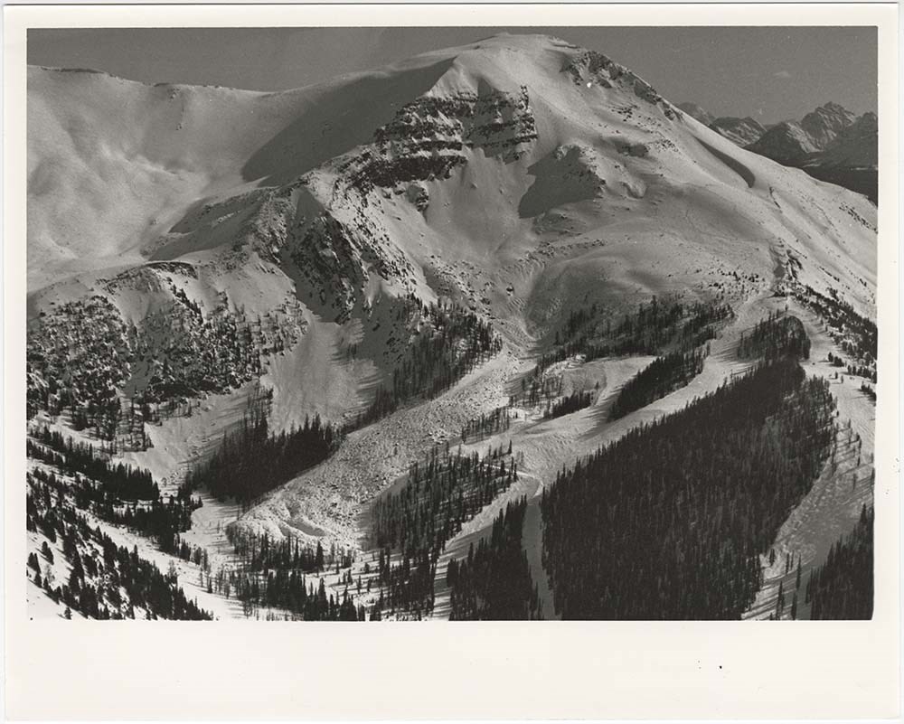
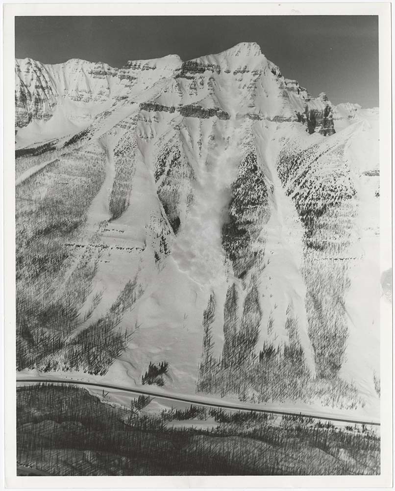
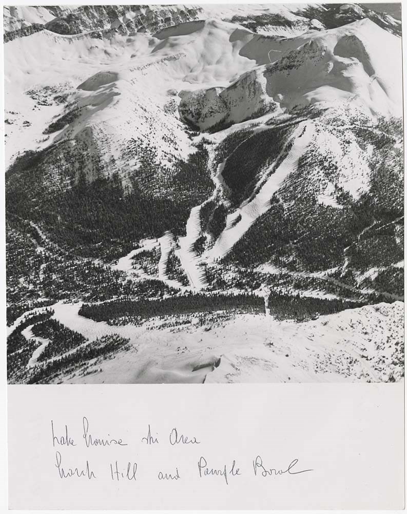
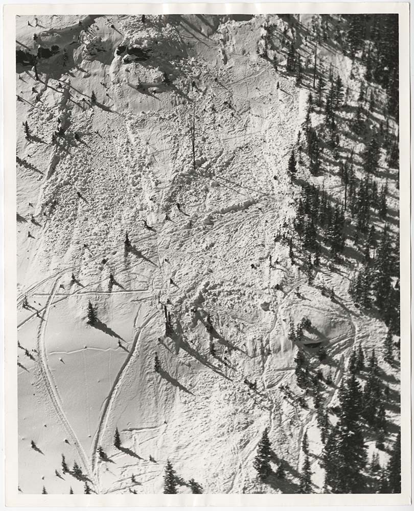
Avalanche Zones
https://archives.whyte.org/en/permalink/descriptions56753
- Part Of
- Bruno Engler fonds
- Scope & Content
- File pertains to 58 b&w prints of various avalanche areas and slides around Banff National Park, mostly focussed along stretches of highways and in and around ski areas, including backcountry ski areas like Assiniboine.
- Date Range
- [ca. 1977-1990]
- Reference Code
- V190 / VI / A / vi / d / PA - 01 to PA - 58
- Description Level
- 5 / File
- GMD
- Photograph
4 images
- Part Of
- Bruno Engler fonds
- Description Level
- 5 / File
- Fonds Number
- M323 / S40 / V190
- Series
- VI : Retained file, A : Alphabetical order
- Sous-Fonds
- V190
- Sub-Series
- vi : Avalanches, d : Zones
- Accession Number
- 7436
- Reference Code
- V190 / VI / A / vi / d / PA - 01 to PA - 58
- GMD
- Photograph
- Date Range
- [ca. 1977-1990]
- Physical Description
- 58 photographs : b&w ; 20.3 x 25.4 cm or smaller
- History / Biographical
- See fonds level description
- Scope & Content
- File pertains to 58 b&w prints of various avalanche areas and slides around Banff National Park, mostly focussed along stretches of highways and in and around ski areas, including backcountry ski areas like Assiniboine.
- Subject Access
- Aerial photography
- Avalanches
- Banff-Jasper Highway
- Backcountry skiing
- Lake Louise Ski Area
- Mountains
- Ski areas
- Sunshine Ski Resort
- Winter
- Geographic Access
- Banff National Park
- Alberta
- Mount Assiniboine
- Mount Assiniboine Provincial Park
- British Columbia
- Language
- English
- Related Material
- V190 / VI / A / vi / d / NA - 01 to NA - 09
- Creator
- Engler, Bruno
- Title Source
- Original title kept
- Processing Status
- Processed
Images
This material is presented as originally created; it may contain outdated cultural descriptions and
potentially offensive content.
Read more.
Avalanche Zones - negatives [1/2]
https://archives.whyte.org/en/permalink/descriptions56754
- Part Of
- Bruno Engler fonds
- Scope & Content
- File pertains to 9 b&w negatives of various avalanche areas and slides around Banff National Park, mostly focussed in and around ski areas.
- Date Range
- [ca. 1977-1990]
- Reference Code
- V190 / VI / A / vi / d / NA - 01 to NA - 09
- Description Level
- 5 / File
- GMD
- Negative
- Part Of
- Bruno Engler fonds
- Description Level
- 5 / File
- Fonds Number
- M323 / S40 / V190
- Series
- VI : Retained file, A : Alphabetical order
- Sous-Fonds
- V190
- Sub-Series
- vi : Avalanches, d : Zones
- Accession Number
- 7436
- Reference Code
- V190 / VI / A / vi / d / NA - 01 to NA - 09
- GMD
- Negative
- Date Range
- [ca. 1977-1990]
- Physical Description
- 9 photographs : b&w negatives ; 15.6 x 6.1 cm or smaller
- History / Biographical
- See fonds level description
- Scope & Content
- File pertains to 9 b&w negatives of various avalanche areas and slides around Banff National Park, mostly focussed in and around ski areas.
- Subject Access
- Aerial photography
- Avalanches
- Banff-Jasper Highway
- Backcountry skiing
- Lake Louise Ski Area
- Mountains
- Ski areas
- Sunshine Ski Resort
- Winter
- Geographic Access
- Banff National Park
- Alberta
- Language
- English
- Related Material
- V190 / VI / A / vi / d / PA - 01 to PA - 58
- Creator
- Engler, Bruno
- Title Source
- Original title kept
- Processing Status
- Processed
This material is presented as originally created; it may contain outdated cultural descriptions and
potentially offensive content.
Read more.
Balfour Hut Registers
https://archives.whyte.org/en/permalink/descriptions57646
- Part Of
- Alpine Club of Canada fonds
- Scope & Content
- Sub-series of hut registers from the Balfour (Rob Ritchie) Hut produced by the Alpine Club of Canada between 1966 and 2019. Registers include entries from visitors to the huts which pertain to individuals' hiking and climbing trips; details of specific events which occurred while staying at the hut…
- Date Range
- 1966-2001
- 2007-2019
- Reference Code
- M200 / IV / I
- Description Level
- 4 / Sub-series
- GMD
- Textual record
- Organization record
- Part Of
- Alpine Club of Canada fonds
- Description Level
- 4 / Sub-series
- Fonds Number
- M200
- V14
- S6
- Series
- M200 / IV: Hut Registers
- Sous-Fonds
- M200
- Sub-Series
- M200 / IV / I: Balfour Hut Registers
- Accession Number
- accn. 2376
- accn. 3298
- accn. 3560
- accn. 7779
- accn. 2023.10
- accn. 2023.31
- accn. 2023.15
- Reference Code
- M200 / IV / I
- Responsibility
- Registers produced by Alpine Club of Canada
- Date Range
- 1966-2001
- 2007-2019
- Physical Description
- 20 cm of textual records 9 volumes
- History / Biographical
- According to the Alpine Club of Canada's website: "The Rob Ritchie Hut, also known as the Balfour Hut, is found on low, rocky hills at the toe of the Vulture Glacier, approximately 28 km northwest of the town of Lake Louise, AB. It is east of Balfour Pass and the Continental divide, just inside the Banff National Park boundary.[...] The Rob Ritchie Hut, also known as the Balfour Hut, is found on low, rocky hills at the toe of the Vulture Glacier, approximately 28 km northwest of the town of Lake Louise, AB. It is east of Balfour Pass and the Continental divide, just inside the Banff National Park boundary. This is the half-way mark for the Wapta Traverse and is usually used in conjunction with the other huts in this chain while attempting this classic cross-glacier ski trip. Usual approach is from Bow Hut through the Olive/St. Nicholas Col then down the gentle and pleasant Vulture Glacier to Balfour Pass, where the hut sits on a section of moraine beneath the impressive bulk of Mt. Balfour. Though most people will spend one night at the R.J. Ritchie (Balfour) Hut before continuing on to Scott Duncan, there is potential for good skiing here, especially on the Diableret Glacier which sits northwest of Mt. Balfour and makes for a fantastic run on a clear day! There is also an optional route to the summit of Mt. Gordon from this hut, which would be an excellent loop trip if combined with the normal route back towards Bow Hut. Use your imagination and some neat trip ideas will present themselves!"
- Scope & Content
- Sub-series of hut registers from the Balfour (Rob Ritchie) Hut produced by the Alpine Club of Canada between 1966 and 2019. Registers include entries from visitors to the huts which pertain to individuals' hiking and climbing trips; details of specific events which occurred while staying at the hut, wildlife sightings, custodial issues and updates, and related topics. The sub-series is separated into individual hut registers, arranged by date:
- M200 / IV / I / 1: Balfour Hut [Register] [1966-1971]
- M200 / IV / I / 2: Balfour Pass Hut [1971-1972]
- M200 / IV / I / 3: Balfour Pass Hut Register [1973-1974]
- M200 / IV / I / 4: Balfour Pass Hut [register 1974-1982]
- M200 / IV / I / 5: "Balfour Hut" [register] Sept. 2, 1982 - Nov. 17, 1989
- M200 / IV / I / 6: Balfour Hut Journal Nov. 22, 1989 - Apr. 25, 1997
- M200 / IV / I / 7: Balfour Hut Register [1997 -2001]
- M200 / IV / I / 8: Balfour Hut Register 2007 - 2015
- M200 / IV / I / 9: Balfour Hut register 2011 - 2019
- Name Access
- Alpine Club of Canada
- Subject Access
- Huts
- Cabins
- Cabins and shelters
- Backcountry skiing
- Banff National Park
- Buildings and facilities
- Climbing
- Environment and Nature
- Lake Louise
- Mountaineering
- Mountains
- Ski mountaineering
- Sports and leisure
- Sports and recreation
- Winter sports
- Wapta Traverse
- Geographic Access
- Canada
- Alberta
- Banff National Park
- Lake Louise, AB
- Access Restrictions
- Restrictions may apply
- Language
- English
- French
- German
- Japanese
- Spanish
- Biographical Source Notes
- Alpine Club of Canada website: https://www.alpineclubofcanada.ca/rob-ritchie-balfour-hut/"
- Title Source
- Title based on contents of sub-series
- Processing Status
- Processed
This material is presented as originally created; it may contain outdated cultural descriptions and
potentially offensive content.
Read more.
Banff National Park (general)
https://archives.whyte.org/en/permalink/descriptions55338
- Part Of
- Murray Hay fonds
- Scope & Content
- File consists of 4 prings : col. 35.1 x 24.8 cm or smaller and 4 maps (2 paper, 2 overlays) : col., on mylar ; 60.4 x 30. cm or smaller. File pertains to aerial views of Banff National Park, showing the towns of Banff and Lake Louise, ski hills (Norqay Ski Hill, Sunshine Village, and Lake Louise Sk…
- Date Range
- ca.1976-ca.2000
- Reference Code
- V795 / II / B / v / 1-2
- Description Level
- 5 / File
- GMD
- Map
- Private record
- Part Of
- Murray Hay fonds
- Description Level
- 5 / File
- Fonds Number
- M570 / V795
- Series
- V795 / II : Unpublished Material
- Sous-Fonds
- V795
- Sub-Series
- V795 / II / B : Alberta / v : Banff National Park
- Accession Number
- 2019.41
- Reference Code
- V795 / II / B / v / 1-2
- GMD
- Map
- Private record
- Date Range
- ca.1976-ca.2000
- Physical Description
- 4 prints : col. 35.1 x 24.8 cm or smaller
- 4 maps (2 paper, 2 overlays) : col., annotations, on mylar ; 60.4 x 30. cm or smaller
- Scope & Content
- File consists of 4 prings : col. 35.1 x 24.8 cm or smaller and 4 maps (2 paper, 2 overlays) : col., on mylar ; 60.4 x 30. cm or smaller. File pertains to aerial views of Banff National Park, showing the towns of Banff and Lake Louise, ski hills (Norqay Ski Hill, Sunshine Village, and Lake Louise Ski Resort), as well as other georgraphic features. The mylar overlays contain various amounts of detail and annotations - one consists of a dark red sheet overlayed with place names in negative.
- Notes
- Items not in oversize stored in downstairs vault.
- Name Access
- Hay, Murray
- Subject Access
- Advertising
- Artist
- Ski Maps
- Map
- Cartography
- Sports and recreation
- Tourism
- Tourist information
- Winter
- Winter sports
- Ski area
- Sunshine Village
- Norquay Ski Hill
- Lake Louise Ski Area
- Geographic Access
- Banff
- Lake Louise
- Banff National Park
- Alberta
- Canada
- Canadian Rocky Mountains
- Language
- English
- Creator
- Hay, Murray
- Title Source
- Title based on contents of file
- Processing Status
- Processed
This material is presented as originally created; it may contain outdated cultural descriptions and
potentially offensive content.
Read more.