File consists of one zoning map depicting the Papaschase Indian Reserve south of the Saskatchewan River and surrounding area. Map is titled "Plan of Township 52 Range 24 West of the Fourth Meridian".
Produced by the Canadian Department of the Interior
Date Range
1908
Physical Description
1 map : b&w photozincograph print ; 34 x 41 cm
Scope & Content
File consists of one zoning map depicting the Papaschase Indian Reserve south of the Saskatchewan River and surrounding area. Map is titled "Plan of Township 52 Range 24 West of the Fourth Meridian".
Alberta - British Columbia Boundary Commission. Photographs by A.O. Wheeler. List of Stations. Vol. 1 (1 of 2 volumes). Numbers 1-37. Included is index of stations and reference to bearings and coordinates of each station surveyed
Alberta - British Columbia Boundary Commission. Photographs by A.O. Wheeler. List of Stations. Vol. 1 (1 of 2 volumes). Numbers 1-37. Included is index of stations and reference to bearings and coordinates of each station surveyed
Alberta - British Columbia Boundary Commission. Photographs by A.O. Wheeler. List of Stations. Vol. 2 (2 of 2 volumes). Numbers 38 - 65. Included is index of stations and reference to bearings and coordinates of each station surveyed
Alberta - British Columbia Boundary Commission. Photographs by A.O. Wheeler. List of Stations. Vol. 2 (2 of 2 volumes). Numbers 38 - 65. Included is index of stations and reference to bearings and coordinates of each station surveyed
Interprovincial boundary survey of Akamina Pass. 58 photographs with description of locations, including bearings and coordinates and in some cases altitude.
Interprovincial boundary survey of Akamina Pass. 58 photographs with description of locations, including bearings and coordinates and in some cases altitude.
Alberta- British Columbia Boundary Commission. Photographs by A.O. Wheeler. Vol. 1. First 45 pages are text describing bearings and coordinates of various viewpoints. Handwritten notes throughout textual portion. 69 photographs follow.
Alberta- British Columbia Boundary Commission. Photographs by A.O. Wheeler. Vol. 1. First 45 pages are text describing bearings and coordinates of various viewpoints. Handwritten notes throughout textual portion. 69 photographs follow.
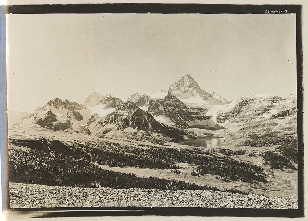
Alberta- British Columbia Boundary Commission. Photographs by A.O. Wheeler. Album 1. Includes list of stations with bearings and coordinates for each related photograph.
1 photograph album: 178 pages
1 fold out map affixed to second page
Scope & Content
Alberta- British Columbia Boundary Commission. Photographs by A.O. Wheeler. Album 1. Includes list of stations with bearings and coordinates for each related photograph.
Alberta- British Columbia Boundary Commission. Photographs by A.O. Wheeler. Album 2. Includes list of stations with bearings and coordinates for each related photograph.
1 photograph album: 195 pages
1 map affixed to second page
Scope & Content
Alberta- British Columbia Boundary Commission. Photographs by A.O. Wheeler. Album 2. Includes list of stations with bearings and coordinates for each related photograph.
Alberta- British Columbia Boundary Commission. Photographs by A.O. Wheeler. Album 3. Includes list of stations with bearings and coordinates for each related photograph.
1 photograph album: 190 pages
1 map affixed to second page
Scope & Content
Alberta- British Columbia Boundary Commission. Photographs by A.O. Wheeler. Album 3. Includes list of stations with bearings and coordinates for each related photograph.
Alberta- British Columbia Boundary Commission. Photographs by A.O. Wheeler. Vol 1. Stations 1-9, Howse Pass and vicinity [label affixed to front cover states Howse and Amiskwi Passes]. Includes list of stations with bearings and coordinates for each related photograph.
Alberta- British Columbia Boundary Commission. Photographs by A.O. Wheeler. Vol 1. Stations 1-9, Howse Pass and vicinity [label affixed to front cover states Howse and Amiskwi Passes]. Includes list of stations with bearings and coordinates for each related photograph.