Royal blue background, Union Jack in top left corner 72.5x56.0, lower right 69.0x59.0 circular emblem. Top is a crown, laurel leaf with bow at bottom surrounds a shield shape with 10 panels. Left side: red cross on white background, 3 leaf clover, white on green, 2 thistles, fish, 1 thistle. Rig…
Royal blue background, Union Jack in top left corner 72.5x56.0, lower right 69.0x59.0 circular emblem. Top is a crown, laurel leaf with bow at bottom surrounds a shield shape with 10 panels. Left side: red cross on white background, 3 leaf clover, white on green, 2 thistles, fish, 1 thistle. Right side: 2 blue stylized sheafs of grain, lion, 3 leaf clover, green on white, sailing ship. Flag appears to be hand screened with some hand in-painting. Rope cord through sewn hem.
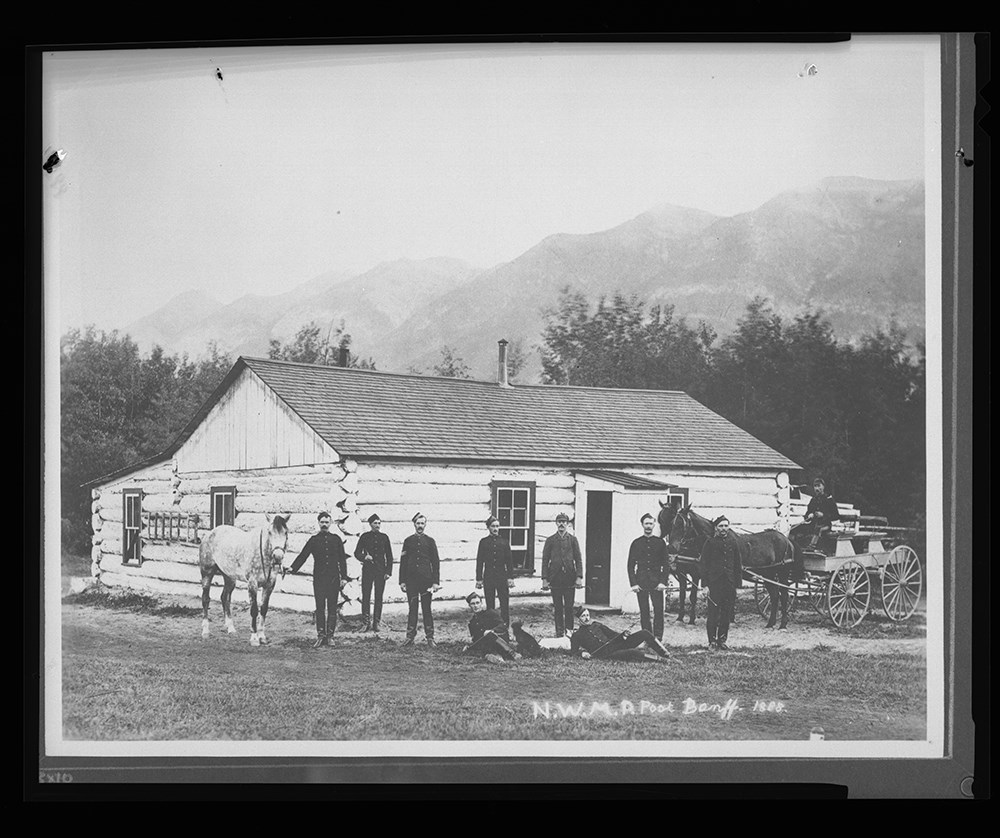
Image of ten men, three horses and a wagon posing in front of a log structure that served as the North West Mounted Police post in Banff [located at 422 Banff Avenue] - caption along bottom reads "N.W.M.P. Post Banff - 1888"
Image of ten men, three horses and a wagon posing in front of a log structure that served as the North West Mounted Police post in Banff [located at 422 Banff Avenue] - caption along bottom reads "N.W.M.P. Post Banff - 1888"
Photograph depicts large crowds and several individuals on a raised stage, during celebrations in Edmonton marking the incorporation of Alberta as a Canadian province, September 1, 1905.
Photograph depicts large crowds and several individuals on a raised stage, during celebrations in Edmonton marking the incorporation of Alberta as a Canadian province, September 1, 1905.
Material Details
Photograph is in dark brown wooden frame with brown paper backing and metal hanging wire attached to back.
File consists of one zoning map depicting the Papaschase Indian Reserve south of the Saskatchewan River and surrounding area. Map is titled "Plan of Township 52 Range 24 West of the Fourth Meridian".
Produced by the Canadian Department of the Interior
Date Range
1908
Physical Description
1 map : b&w photozincograph print ; 34 x 41 cm
Scope & Content
File consists of one zoning map depicting the Papaschase Indian Reserve south of the Saskatchewan River and surrounding area. Map is titled "Plan of Township 52 Range 24 West of the Fourth Meridian".
File consists of one copy of published text titled "Calgary Alberta Canada: Souvenir Edition 1914" [ed. B.S. White]. Pertains to the early settlement history, business development and expansion of Calgary, with articles featuring numerous local business owners, politicians and other professionals.
Produced by the Western Standard Publishing Company
Date Range
1914
Physical Description
0.7 cm of textual records (1 volume ; 26 x 36.5 cm)
Scope & Content
File consists of one copy of published text titled "Calgary Alberta Canada: Souvenir Edition 1914" [ed. B.S. White]. Pertains to the early settlement history, business development and expansion of Calgary, with articles featuring numerous local business owners, politicians and other professionals.
Notes
First page annotated in pencil: "D. M.Dougall" [likely David McDougall]