Narrow Results By
[Anahim Lake, B.C.] Canada Land Inventory Map, Land capability for wildlife-ungulates
https://archives.whyte.org/en/permalink/catalogue24004
- Medium
- Library - Maps and blueprints (unannotated; published)
- Map
- Published Date
- 1971
- Publisher
- Dept. of Energy, Mines and Resources
- Call Number
- NTS
- 93C
- Publisher
- Dept. of Energy, Mines and Resources
- Published Date
- 1971
- Physical Description
- 1 map : col
- Scale
- Scale: 1:250,000
- Subjects
- Anahim Lake
- British Columbia
- Accession Number
- 4000
- Call Number
- NTS
- 93C
- Collection
- Archives Library
This material is presented as originally created; it may contain outdated cultural descriptions and
potentially offensive content.
Read more.
[Angus Horne Lake 83D/5 B.C.]
https://archives.whyte.org/en/permalink/catalogue23450
- Medium
- Library - Maps and blueprints (unannotated; published)
- Map
- Published Date
- 1972
- Publisher
- Department of Energy, Mines and Resources
- Call Number
- NTS
- 83D/5
- Publisher
- Department of Energy, Mines and Resources
- Published Date
- 1972
- Physical Description
- 1 map : col
- Scale
- Scale: 1:50,000
- Relief: Contour interval 100 ft.
- Subjects
- Angus Horne Lake
- British Columbia
- Notes
- National Topographic System
- Accession Number
- 7000
- Call Number
- NTS
- 83D/5
- Collection
- Archives Library
This material is presented as originally created; it may contain outdated cultural descriptions and
potentially offensive content.
Read more.
[Azure River 83D/12 B.C.]
https://archives.whyte.org/en/permalink/catalogue23458
- Medium
- Library - Maps and blueprints (unannotated; published)
- Map
- Published Date
- 1972
- Publisher
- Department of Energy, Mines and Resources
- Call Number
- NTS
- 83D/12
- Publisher
- Department of Energy, Mines and Resources
- Published Date
- 1972
- Physical Description
- 1 map : col
- Scale
- Scale: 1:50,000
- Relief: Contour interval 100 ft.
- Subjects
- Azure River
- British Columbia
- Notes
- National Topographic System
- Accession Number
- 7000
- 7030
- Call Number
- NTS
- 83D/12
- Collection
- Archives Library
This material is presented as originally created; it may contain outdated cultural descriptions and
potentially offensive content.
Read more.
B.C. Highway map
https://archives.whyte.org/en/permalink/catalogue24515
- Medium
- Library - Maps and blueprints (unannotated; published)
- Map
- Published Date
- 1975-76
- Publisher
- Lawson Graphics (Pacific)
- Call Number
- C10-1.4
- Publisher
- Lawson Graphics (Pacific)
- Published Date
- 1975-76
- Scale
- Scale: 1 inch - 34 miles
- Subjects
- British Columbia
- Highways
- Call Number
- C10-1.4
- Collection
- Archives Library
This material is presented as originally created; it may contain outdated cultural descriptions and
potentially offensive content.
Read more.
[British Columbia Highway] Highway map
https://archives.whyte.org/en/permalink/catalogue24514
- Medium
- Library - Maps and blueprints (unannotated; published)
- Map
- Published Date
- 1975-76
- Publisher
- Grant-Mann Lithographers Ltd.
- Call Number
- C10-1.3
- Publisher
- Grant-Mann Lithographers Ltd.
- Published Date
- 1975-76
- Scale
- Scale: 1 inch - 34 miles
- Subjects
- British Columbia
- Highways
- Call Number
- C10-1.3
- Collection
- Archives Library
This material is presented as originally created; it may contain outdated cultural descriptions and
potentially offensive content.
Read more.
[Bute Inlet, B.C.] Canada Land Inventory Map, Land capability for wildlife-ungulates
https://archives.whyte.org/en/permalink/catalogue24016
- Medium
- Library - Maps and blueprints (unannotated; published)
- Map
- Published Date
- 1971
- Publisher
- Dept. of Energy, Mines and Resouces
- Call Number
- NTS
- 92K
- Publisher
- Dept. of Energy, Mines and Resouces
- Published Date
- 1971
- Physical Description
- 1 map : col
- Scale
- Scale: 1:250,000
- Subjects
- Bute Inlet
- British Columbia
- Accession Number
- 4000
- Call Number
- NTS
- 92K
- Collection
- Archives Library
This material is presented as originally created; it may contain outdated cultural descriptions and
potentially offensive content.
Read more.
[Chase 82L/13 B.C.]
https://archives.whyte.org/en/permalink/catalogue23547
- Medium
- Library - Maps and blueprints (unannotated; published)
- Map
- Published Date
- 1973
- Publisher
- Department of Energy, Mines and Resources
- Call Number
- NTS
- 82L/I3
- Publisher
- Department of Energy, Mines and Resources
- Published Date
- 1973
- Physical Description
- 1 map : col
- Scale
- Scale: 1:50,000
- Relief: Contour interval 100 ft.
- Subjects
- Chase
- British Columbia
- Notes
- National Topographic System
- Accession Number
- 7000
- Call Number
- NTS
- 82L/I3
- Collection
- Archives Library
This material is presented as originally created; it may contain outdated cultural descriptions and
potentially offensive content.
Read more.
[Cottonwood River, B.C.] Canada Land Inventory Map, Land Capability for Forestry
https://archives.whyte.org/en/permalink/catalogue23961
- Medium
- Library - Maps and blueprints (unannotated; published)
- Map
- Published Date
- 1972
- Publisher
- Department of Energy, Mines and Resources
- Call Number
- NTS
- 93G/SE
- Publisher
- Department of Energy, Mines and Resources
- Published Date
- 1972
- Physical Description
- 1 map : col
- Scale
- Scale: 1:125,000
- Subjects
- Cottonwood River
- British Columbia
- Accession Number
- 7000
- Call Number
- NTS
- 93G/SE
- Collection
- Archives Library
This material is presented as originally created; it may contain outdated cultural descriptions and
potentially offensive content.
Read more.
[Cranbrook, B.C.] Canada Land Inventory Map, Land Capability for Forestry
https://archives.whyte.org/en/permalink/catalogue23962
- Medium
- Library - Maps and blueprints (unannotated; published)
- Map
- Published Date
- 1972
- Publisher
- Department of Energy, Mines and Resources
- Call Number
- NTS
- 82G/NW, NE
- Publisher
- Department of Energy, Mines and Resources
- Published Date
- 1972
- Physical Description
- 1 map : col
- Scale
- Scale: 1:125,000
- Subjects
- Cranbrook
- British Columbia
- Accession Number
- 7000
- Call Number
- NTS
- 82G/NW, NE
- Collection
- Archives Library
This material is presented as originally created; it may contain outdated cultural descriptions and
potentially offensive content.
Read more.
[Elko, B.C.] Canada Land Inventory Map, Land Capability for Forestry
https://archives.whyte.org/en/permalink/catalogue23963
- Medium
- Library - Maps and blueprints (unannotated; published)
- Map
- Published Date
- 1972
- Publisher
- Dept. of Energy, Mines and Resources
- Call Number
- NTS
- 82G/SW
- Publisher
- Dept. of Energy, Mines and Resources
- Published Date
- 1972
- Physical Description
- 1 map : col
- Scale
- Scale: 1:125,000
- Subjects
- Elko
- British Columbia
- Accession Number
- 6500
- Call Number
- NTS
- 82G/SW
- Collection
- Archives Library
This material is presented as originally created; it may contain outdated cultural descriptions and
potentially offensive content.
Read more.
[Flathead, B.C.] Canada Land Inventory Map, Land Capability for Forestry
https://archives.whyte.org/en/permalink/catalogue23964
- Medium
- Library - Maps and blueprints (unannotated; published)
- Map
- Published Date
- 1972
- Publisher
- Dept. of Energy, Mines and Resources
- Call Number
- NTS
- 82G/SE
- Publisher
- Dept. of Energy, Mines and Resources
- Published Date
- 1972
- Physical Description
- 1 map : col
- Scale
- Scale: 1:125,000
- Subjects
- Flathead
- British Columbia
- Accession Number
- 6500
- Call Number
- NTS
- 82G/SE
- Collection
- Archives Library
This material is presented as originally created; it may contain outdated cultural descriptions and
potentially offensive content.
Read more.
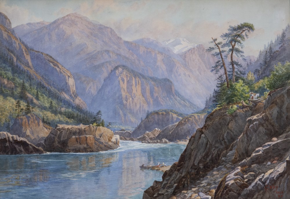
The Fraser River at Yale BC
https://archives.whyte.org/en/permalink/artifactwac.05.01
- Date
- c. 1900
- Medium
- watercolour on paper
- Catalogue Number
- WaC.05.01
- Description
- River winding through rocky mountains. River is calm in foreground and rougher in background. 4 figures on beach with two canoes at center right. Another figure with white pack horse on rocky outcrop above. Mountains primarily brown and grey with one snowcapped peak in distance. Trees and other shr…
1 image
- Title
- The Fraser River at Yale BC
- Date
- c. 1900
- Medium
- watercolour on paper
- Dimensions
- 52.0 x 75.5 cm
- Description
- River winding through rocky mountains. River is calm in foreground and rougher in background. 4 figures on beach with two canoes at center right. Another figure with white pack horse on rocky outcrop above. Mountains primarily brown and grey with one snowcapped peak in distance. Trees and other shrubbery on rocky outcrop at right and on slopes at left and center distance. “CJ (overlapping) Way YALE BC” in red at lower right. In ornately carved gold painted wood frame with glass. White tag from Masters Gallery Ltd. on back.
- Credit
- Gift of Robyn L Fulton, 2021
- Catalogue Number
- WaC.05.01
Images
This material is presented as originally created; it may contain outdated cultural descriptions and
potentially offensive content.
Read more.
[Invermere, B.C.] Canada Land Inventory Map, Soil Capability for Agriculture
https://archives.whyte.org/en/permalink/catalogue23965
- Medium
- Library - Maps and blueprints (unannotated; published)
- Map
- Published Date
- 1972
- Publisher
- Department of Energy, Mines and Resources
- Call Number
- NTS
- 82K/NE
- Publisher
- Department of Energy, Mines and Resources
- Published Date
- 1972
- Physical Description
- 1 map : col
- Scale
- Scale: 1:125,000
- Subjects
- Invermere
- British Columbia
- Accession Number
- 4000
- Call Number
- NTS
- 82K/NE
- Collection
- Archives Library
This material is presented as originally created; it may contain outdated cultural descriptions and
potentially offensive content.
Read more.
[Kiwa Creek 83D/13, B.C.]
https://archives.whyte.org/en/permalink/catalogue23704
- Medium
- Library - Maps and blueprints (unannotated; published)
- Map
- Published Date
- 1973
- Publisher
- Department of Energy, Mines and Resources
- Call Number
- NTS
- 83D/13
- Publisher
- Department of Energy, Mines and Resources
- Published Date
- 1973
- Physical Description
- 1 map : col
- Scale
- Scale: 1:50,000
- Relief: Contour interval 100 ft.
- Subjects
- Kiwa Creek
- British Columbia
- Notes
- National Topographic System
- Accession Number
- 7000
- Call Number
- NTS
- 83D/13
- Collection
- Archives Library
This material is presented as originally created; it may contain outdated cultural descriptions and
potentially offensive content.
Read more.
[Mount Assiniboine 82J/NW, B.C.]
https://archives.whyte.org/en/permalink/catalogue23990
- Medium
- Library - Maps and blueprints (unannotated; published)
- Map
- Published Date
- 1971
- Publisher
- Dept. of Lands and Forests & Water Resources
- Call Number
- NTS
- 82J/NW
- Publisher
- Dept. of Lands and Forests & Water Resources
- Published Date
- 1971
- Physical Description
- 1 map : col
- Scale
- Scale: 1:126,720
- Relief: Contour Interval 100 ft.
- Subjects
- Mount Assiniboine
- British Columbia
- Notes
- National Topographic System
- Accession Number
- 3000
- Call Number
- NTS
- 82J/NW
- Collection
- Archives Library
This material is presented as originally created; it may contain outdated cultural descriptions and
potentially offensive content.
Read more.
[Mount Assiniboine, B.C.] Canada Land Inventory Map, Land Capability for Forestry
https://archives.whyte.org/en/permalink/catalogue23966
- Medium
- Library - Maps and blueprints (unannotated; published)
- Map
- Published Date
- 1973
- Publisher
- Department of Energy, Mines and Resources
- Call Number
- NTS
- 82J/NW
- Publisher
- Department of Energy, Mines and Resources
- Published Date
- 1973
- Physical Description
- 1 map : col
- Scale
- Scale: 1:125,000
- Subjects
- Mount Assiniboine
- British Columbia
- Accession Number
- 7000
- Call Number
- NTS
- 82J/NW
- Collection
- Archives Library
This material is presented as originally created; it may contain outdated cultural descriptions and
potentially offensive content.
Read more.
[Mount Assiniboine, B.C.] Canada Land Inventory Map, Soil Capability for Agriculture
https://archives.whyte.org/en/permalink/catalogue24099
- Medium
- Library - Maps and blueprints (unannotated; published)
- Map
- Published Date
- 1972
- Publisher
- Dept. of Energy, Mines and Resources
- Call Number
- NTS
- 82J/NW
- Publisher
- Dept. of Energy, Mines and Resources
- Published Date
- 1972
- Physical Description
- 1 map : col
- Scale
- Scake: 1:250,000
- Subjects
- Mount Assiniboine
- British Columbia
- Accession Number
- 6000
- Call Number
- NTS
- 82J/NW
- Collection
- Archives Library
This material is presented as originally created; it may contain outdated cultural descriptions and
potentially offensive content.
Read more.
[Nass River, B.C.] Canada Land Inventory Map, Land capability for wildlife-waterfowl
https://archives.whyte.org/en/permalink/catalogue24110
- Medium
- Library - Maps and blueprints (unannotated; published)
- Map
- Published Date
- 1970
- Publisher
- Dept. of Energy, Mines and Resources
- Call Number
- NTS
- 103PQ
- Publisher
- Dept. of Energy, Mines and Resources
- Published Date
- 1970
- Physical Description
- 1 map : col
- Scale
- Scale: 1:250,000
- Subjects
- Nass River
- British Columbia
- Accession Number
- 4000
- Call Number
- NTS
- 103PQ
- Collection
- Archives Library
This material is presented as originally created; it may contain outdated cultural descriptions and
potentially offensive content.
Read more.
[Nechako River, B.C.] Canada Land Inventory Map, Land capability for recreation
https://archives.whyte.org/en/permalink/catalogue24111
- Medium
- Library - Maps and blueprints (unannotated; published)
- Map
- Published Date
- 1970
- Publisher
- Department of Energy, Mines and Resources
- Call Number
- NTS
- 93F
- Publisher
- Department of Energy, Mines and Resources
- Published Date
- 1970
- Physical Description
- 1 map : col
- Scale
- Scale: 1:250,000
- Subjects
- Nechako River
- British Columbia
- Accession Number
- 4000
- Call Number
- NTS
- 93F
- Collection
- Archives Library
This material is presented as originally created; it may contain outdated cultural descriptions and
potentially offensive content.
Read more.
[Nechako River, B.C.] Canada Land Inventory Map, Land capability for recreation
https://archives.whyte.org/en/permalink/catalogue24112
- Medium
- Library - Maps and blueprints (unannotated; published)
- Map
- Published Date
- 1970
- Publisher
- Dept. of Energy, Mines and Resources
- Call Number
- NTS
- 93F
- Publisher
- Dept. of Energy, Mines and Resources
- Published Date
- 1970
- Physical Description
- 1 map : col
- Scale
- Scale: 1:250,000
- Subjects
- Nechako River
- British Columbia
- Accession Number
- 4000
- Call Number
- NTS
- 93F
- Collection
- Archives Library
This material is presented as originally created; it may contain outdated cultural descriptions and
potentially offensive content.
Read more.