Narrow Results By
- Date
- 1890 – 1900
- Material
- skin; metal; glass
- Catalogue Number
- 103.07.0003
- Description
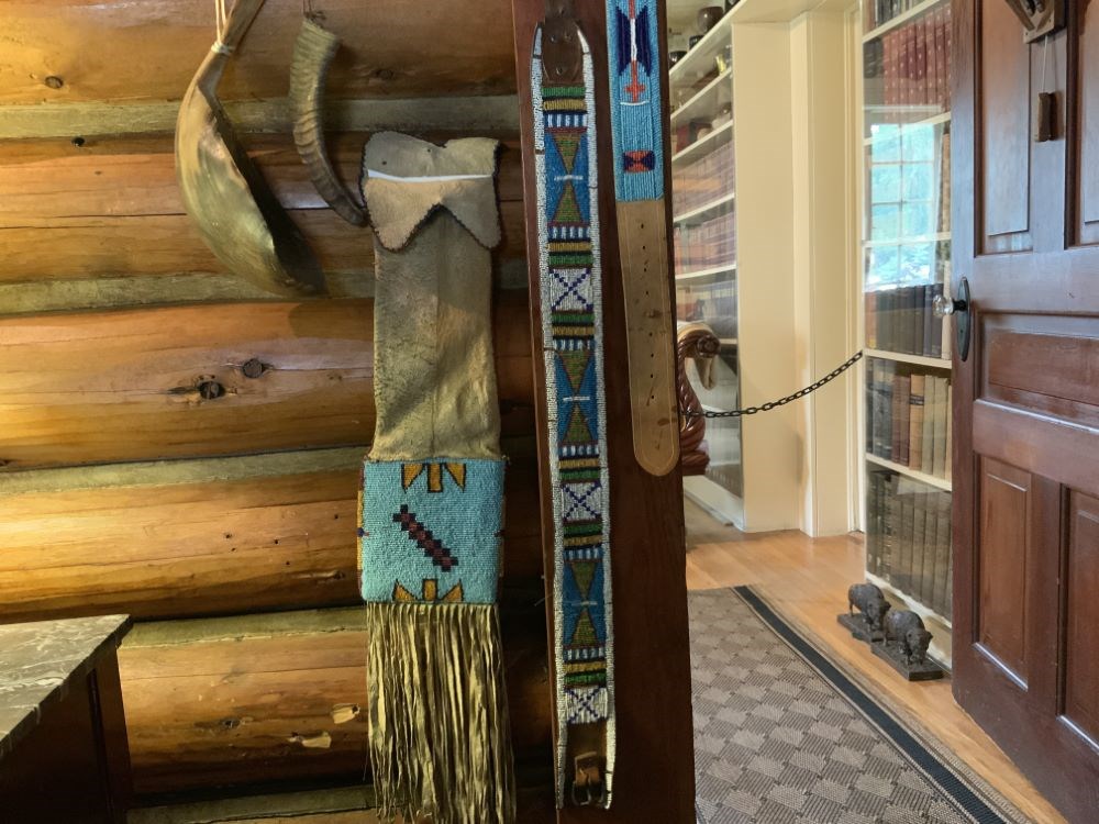
- A woman's beaded harness belt with a leather strap and buckle at opposite ends. The belt has a white border and three white squares with crosses of coloured beads separating patterned sections of blue, mustard, red and green beads.
1 image
- Title
- Beaded Belt
- Date
- 1890 – 1900
- Material
- skin; metal; glass
- Dimensions
- 5.5 x 89.0 cm
- Description
- A woman's beaded harness belt with a leather strap and buckle at opposite ends. The belt has a white border and three white squares with crosses of coloured beads separating patterned sections of blue, mustard, red and green beads.
- Credit
- Gift of Pearl Evelyn Moore, Banff, 1979
- Catalogue Number
- 103.07.0003
Images
This material is presented as originally created; it may contain outdated cultural descriptions and
potentially offensive content.
Read more.
- Date
- 1940 – 1960
- Material
- fibre; glass
- Catalogue Number
- 103.05.3026
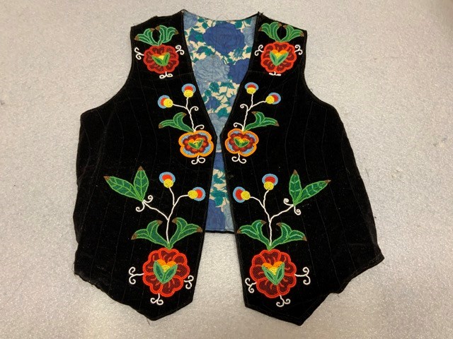
- Description
- Black velvet vest with parallel machine sewn lines. The vest is lined with printed blue floral patterned cotton. The front of the vest is decorated with a floral motif in orange, red, green and yellow with red, blue and yellow buds and green leaves. The back of the vest is beaded with a man wear…
1 image
- Title
- Beaded Vest
- Date
- 1940 – 1960
- Material
- fibre; glass
- Dimensions
- 54.5 x 62.2 cm
- Description
- Black velvet vest with parallel machine sewn lines. The vest is lined with printed blue floral patterned cotton. The front of the vest is decorated with a floral motif in orange, red, green and yellow with red, blue and yellow buds and green leaves. The back of the vest is beaded with a man wearing a headress of black and white feathers and a blue shirt with red and yellow beadstrips.
- Credit
- Gift of Catharine Robb Whyte, O. C., Banff, 1979
- Catalogue Number
- 103.05.3026
Images
This material is presented as originally created; it may contain outdated cultural descriptions and
potentially offensive content.
Read more.
- Medium
- Library - Maps and blueprints (unannotated; published)
- Map
- Published Date
- 1963
- Publisher
- Dept. of Lands, Forests & Water Resources
- Call Number
- NTS
- 82G/SE
- Publisher
- Dept. of Lands, Forests & Water Resources
- Published Date
- 1963
- Physical Description
- 1 map : col
- Scale
- Scale: 1:126,720
- Relief: Contour interval 100 ft.
- Subjects
- Flathead
- Notes
- National Topographic System
- Accession Number
- 3000
- 6802
- Call Number
- NTS
- 82G/SE
- Collection
- Archives Library
This material is presented as originally created; it may contain outdated cultural descriptions and
potentially offensive content.
Read more.
[Flathead, B.C.] Canada Land Inventory Map, Land Capability for Forestry
https://archives.whyte.org/en/permalink/catalogue23964
- Medium
- Library - Maps and blueprints (unannotated; published)
- Map
- Published Date
- 1972
- Publisher
- Dept. of Energy, Mines and Resources
- Call Number
- NTS
- 82G/SE
- Publisher
- Dept. of Energy, Mines and Resources
- Published Date
- 1972
- Physical Description
- 1 map : col
- Scale
- Scale: 1:125,000
- Subjects
- Flathead
- British Columbia
- Accession Number
- 6500
- Call Number
- NTS
- 82G/SE
- Collection
- Archives Library
This material is presented as originally created; it may contain outdated cultural descriptions and
potentially offensive content.
Read more.
Flathead Ridge, British Columbia-Alberta
https://archives.whyte.org/en/permalink/catalogue23618
- Medium
- Library - Maps and blueprints (unannotated; published)
- Map
- Published Date
- 1984
- Publisher
- Ottawa : Surveys and Mapping Branch, Dept. of Energy, Mines and Resources
- Edition
- 3d ed.
- Call Number
- NTS
- 82G/7
- Edition
- 3d ed.
- Publisher
- Ottawa : Surveys and Mapping Branch, Dept. of Energy, Mines and Resources
- Published Date
- 1984
- Physical Description
- 1 map : col
- Scale
- Scale: 1:50,000
- Subjects
- Flathead Ridge
- British Columbia/Alberta
- Accession Number
- 27,000
- Call Number
- NTS
- 82G/7
- Collection
- Archives Library
This material is presented as originally created; it may contain outdated cultural descriptions and
potentially offensive content.
Read more.
John McLatchie, O.L.S., D.L.S., P.L.S. (B.C. No. 39, 1897), 1842-1908
https://archives.whyte.org/en/permalink/catalogue7378
- Medium
- Library - Book (including soft-cover and pamphlets)
- Published Date
- 1988
- Author
- Andrews, Gerald Smedley
- Call Number
- 03.7 M22a Pam
- Author
- Andrews, Gerald Smedley
- Published Date
- 1988
- Physical Description
- 5p. : ill., ports
- Subjects
- Boundaries
- Crowsnest Pass
- Flathead
- Notes
- Bibliography
- Call Number
- 03.7 M22a Pam
- Collection
- Archives Library
This material is presented as originally created; it may contain outdated cultural descriptions and
potentially offensive content.
Read more.
[Lower Flathead 82G/2 East, B.C.]
https://archives.whyte.org/en/permalink/catalogue23723
- Medium
- Library - Maps and blueprints (unannotated; published)
- Map
- Published Date
- 1959
- Publisher
- Dept. of Mines and Technical Surveys
- Call Number
- NTS
- 82G/2E
- Publisher
- Dept. of Mines and Technical Surveys
- Published Date
- 1959
- Physical Description
- 1 map : col
- Scale
- Scale: 1:50,000
- Relief: Contour interval 100'
- Subjects
- Lower Flathead
- British Columbia
- Notes
- National Topographic System
- Call Number
- NTS
- 82G/2E
- Collection
- Archives Library
This material is presented as originally created; it may contain outdated cultural descriptions and
potentially offensive content.
Read more.
[Lower Flathead 82G/2 West, B.C.]
https://archives.whyte.org/en/permalink/catalogue23724
- Medium
- Library - Maps and blueprints (unannotated; published)
- Map
- Published Date
- 1959
- Publisher
- Dept. of Mines and Technical Surveys
- Call Number
- NTS
- 82G/2W
- Publisher
- Dept. of Mines and Technical Surveys
- Published Date
- 1959
- Physical Description
- 1 map : col
- Scale
- Scale: 1:50,000
- Relief: Contour interval 100'
- Subjects
- Lower Flathead
- British Columbia
- Notes
- National Topographic System
- Call Number
- NTS
- 82G/2W
- Collection
- Archives Library
This material is presented as originally created; it may contain outdated cultural descriptions and
potentially offensive content.
Read more.
A river to ruin
https://archives.whyte.org/en/permalink/catalogue13621
- Author
- Hule, Jeff
- Physical Description
- p.42-52 : ill
- Medium
- Library - Periodical
- Subjects
- Coal and coal mines
- Crowsnest Pass
- Flathead
- Notes
- In Canadian Geographic, vol.128, no.3 (June 2008)
- Call Number
- P
- Collection
- Archives Library
This material is presented as originally created; it may contain outdated cultural descriptions and
potentially offensive content.
Read more.
Summary report, 1912
https://archives.whyte.org/en/permalink/catalogue5836
- Medium
- Library - Book (including soft-cover and pamphlets)
- Published Date
- 1914
- Author
- Geological Survey of Canada
- Call Number
- 03.1 G29su 1912
- Author
- Geological Survey of Canada
- Responsibility
- articles by John A. Allan, K.G. Chipman, Reginald Aldworth Daly, B.R. Mackay, S.C. McLean, John D. MacKenzie, Heinrich Ries, Stuart J. Schofield
- Published Date
- 1914
- Physical Description
- p.156-164, 165-176, 221-228, 229-233, 234, 235-246, 418-419, 421-422, 425-436
- Subjects
- Blairmore
- Canadian Pacific Railway
- Flathead
- Kootenay region
- Oldman River
- Purcell Mountains
- Selkirk Mountains
- Windermere
- Accession Number
- 4000
- Call Number
- 03.1 G29su 1912
- Collection
- Archives Library
This material is presented as originally created; it may contain outdated cultural descriptions and
potentially offensive content.
Read more.