Narrow Results By
- Peter Whyte (1905 – 1966, Canadian) 802
- Charles John Collings (1848 – 1931, British) 515
- Catharine Robb Whyte, O. C. (1906 – 1979, Canadian) 77
- Peter or Catharine Whyte 71
- Les Graff (1936 – , Canadian) 50
- Henry George Glyde (1906 – 1998, Canadian) 36
- Norah Drummond-Davies (1862 – 1949, Canadian) 14
- Peggy Dixon 7
- Pond, Peter 6
- Robert William Sinclair (1939 – , Canadian) 6
- James McLaren Nicoll (1892 – 1986, Canadian) 5
- Alfred Crocker Leighton, R. C. A. (1901 – 1965, Canadian) 4
- Date
- c. 1925
- Medium
- graphite on paper
- Catalogue Number
- WyP.03.954 o
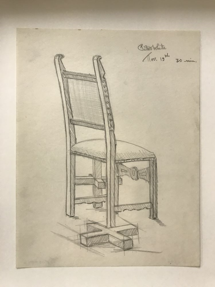
- Description
- chair and 3-d plus sign
1 image
- Title
- 30 Min.
- Date
- c. 1925
- Medium
- graphite on paper
- Dimensions
- 29.5 x 23.0 cm
- Description
- chair and 3-d plus sign
- Subject
- chair
- Credit
- Gift of Catharine Robb Whyte, O. C., Banff, 1975
- Catalogue Number
- WyP.03.954 o
Images
This material is presented as originally created; it may contain outdated cultural descriptions and
potentially offensive content.
Read more.
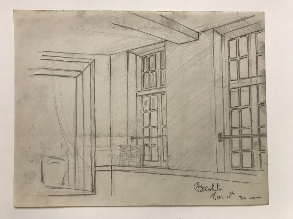
- Date
- 1925
- Medium
- graphite on paper
- Catalogue Number
- WyP.03.954 y
- Description
- Wall with two windows
1 image
- Title
- 30 Min.
- Date
- 1925
- Medium
- graphite on paper
- Dimensions
- 23.0 x 29.5 cm
- Description
- Wall with two windows
- Subject
- window
- Credit
- Gift of Catharine Robb Whyte, O. C., Banff, 1975
- Catalogue Number
- WyP.03.954 y
Images
This material is presented as originally created; it may contain outdated cultural descriptions and
potentially offensive content.
Read more.
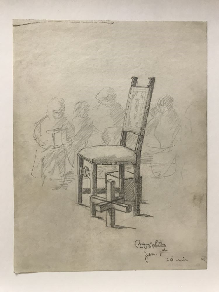
- Date
- c. 1926
- Medium
- graphite on paper
- Catalogue Number
- WyP.03.954 w
- Description
- hatching chair, jack, box with shaded people in background
1 image
- Title
- 50 Min.
- Date
- c. 1926
- Medium
- graphite on paper
- Dimensions
- 29.5 x 23.0 cm
- Description
- hatching chair, jack, box with shaded people in background
- Credit
- Gift of Catharine Robb Whyte, O. C., Banff, 1975
- Catalogue Number
- WyP.03.954 w
Images
This material is presented as originally created; it may contain outdated cultural descriptions and
potentially offensive content.
Read more.
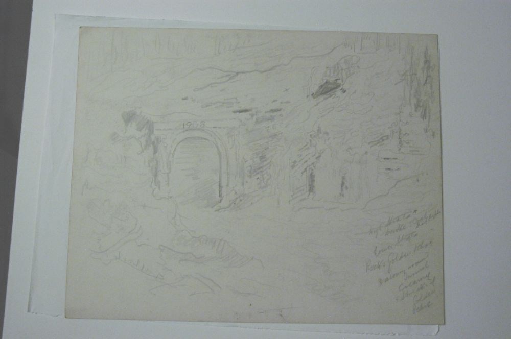
1908 Railway Tunnel (Continental Divide on back)
https://archives.whyte.org/en/permalink/artifactcoj.03.322
- Date
- c. 1911
- Medium
- graphite on paper
- Catalogue Number
- CoJ.03.322
- Description
- Front: the entrance to a railway tunnel is on the left, and muontain and trees surround it. Above the entrance is written “1908” and then his writing for a colour scheme in the brc.Back: mountains and trees surround a valley running through the picture. Writing in the brc: “VICTORIA RIDGE OVER 10…
1 image
- Title
- 1908 Railway Tunnel (Continental Divide on back)
- Date
- c. 1911
- Medium
- graphite on paper
- Dimensions
- 28.0 x 35.5 cm
- Description
- Front: the entrance to a railway tunnel is on the left, and muontain and trees surround it. Above the entrance is written “1908” and then his writing for a colour scheme in the brc.Back: mountains and trees surround a valley running through the picture. Writing in the brc: “VICTORIA RIDGE OVER 10,000feet, 33 BELOW zero, CONTINENTAL DIVIDE FEB 23”
- Subject
- landscape
- Credit
- Gift of John Rivette, Seymour Arm, 1997
- Catalogue Number
- CoJ.03.322
Images
This material is presented as originally created; it may contain outdated cultural descriptions and
potentially offensive content.
Read more.
1978 map of Mount Assiniboine Provincial Park
https://archives.whyte.org/en/permalink/catalogue21315
- Medium
- Library - Maps and blueprints (unannotated; published)
- Map
- Published Date
- 1978 (transfered to manuscrpits Oct. 1994)
- Publisher
- Ministry of Recreation and Conservation
- Call Number
- C2-10.1 (e)
- Publisher
- Ministry of Recreation and Conservation
- Published Date
- 1978 (transfered to manuscrpits Oct. 1994)
- Subjects
- Mount Assiniboine Provincial Park
- Notes
- Descriptive Legend on back of map re: History Winter Activity, Access, Avalanche Safety, Equipment, Trail and Camping Information etc.
- Accession Number
- 11000
- Call Number
- C2-10.1 (e)
- Collection
- Archives Library
This material is presented as originally created; it may contain outdated cultural descriptions and
potentially offensive content.
Read more.
(a): Topographical sheets|(b): Original map
https://archives.whyte.org/en/permalink/catalogue24654
- Medium
- Library - Maps and blueprints (unannotated; published)
- Map
- Published Date
- 1889
- Publisher
- Dept. of the Interior
- Call Number
- C3-8.14 (a)
- C3-8.14 (b)
- Publisher
- Dept. of the Interior
- Published Date
- 1889
- Scale
- Scale:1:40,000
- Relief: Contour interval 100 ft.
- Subjects
- Anthracite
- Notes
- (b): 8 dup in map room
- Accession Number
- 675
- 400
- 3069
- Call Number
- C3-8.14 (a)
- C3-8.14 (b)
- Collection
- Archives Library
This material is presented as originally created; it may contain outdated cultural descriptions and
potentially offensive content.
Read more.
AAF aeronautical chart : North Saskatchewan River / compiled for the U.S. Army Air Forces by the U.S. Coast and Geodetic Survey
https://archives.whyte.org/en/permalink/catalogue24364
- Medium
- Library - Maps and blueprints (unannotated; published)
- Map
- Published Date
- 1943
- Publisher
- Washington, D.C.
- Call Number
- C6-12.1
- Publisher
- Washington, D.C.
- Published Date
- 1943
- Physical Description
- 1 map : col
- Scale
- 1 : 1,000,000
- Subjects
- Saskatchewan River, North
- Aviation
- Accession Number
- 4008
- Call Number
- C6-12.1
- Collection
- Archives Library
This material is presented as originally created; it may contain outdated cultural descriptions and
potentially offensive content.
Read more.
Abruzzi, Mount
https://archives.whyte.org/en/permalink/catalogue23436
- Medium
- Library - Maps and blueprints (unannotated; published)
- Map
- Published Date
- Updated from aerial photographs, taken in 1972. Culture check, 1975. Info current as of 1975.
- Publisher
- Surveys and Mapping Branch, Dept. of Energy, Mines and Resources
- Edition
- Edition 2
- Call Number
- NTS
- 82J/6
- Edition
- Edition 2
- Publisher
- Surveys and Mapping Branch, Dept. of Energy, Mines and Resources
- Published Date
- Updated from aerial photographs, taken in 1972. Culture check, 1975. Info current as of 1975.
- Scale
- Scale: 1:50,000
- Subjects
- Mount Abruzzi
- Notes
- National Topographic System
- Complete reference/reverse side of map
- Accession Number
- 9500
- Call Number
- NTS
- 82J/6
- Collection
- Archives Library
This material is presented as originally created; it may contain outdated cultural descriptions and
potentially offensive content.
Read more.
[Abruzzi, Mount 82J/6 East, B.C.]
https://archives.whyte.org/en/permalink/catalogue23438
- Medium
- Library - Maps and blueprints (unannotated; published)
- Map
- Published Date
- 1966
- Publisher
- Dept. of Mines and Technical Surveys
- Call Number
- NTS
- 82J/6E
- Publisher
- Dept. of Mines and Technical Surveys
- Published Date
- 1966
- Physical Description
- 1 map : col
- Scale
- Scale: 1:50,000
- Relief: Contour interval 100'
- Subjects
- Mount Abruzzi
- British Columbia
- Notes
- National Topographic System
- Accession Number
- 718
- Call Number
- NTS
- 82J/6E
- Collection
- Archives Library
This material is presented as originally created; it may contain outdated cultural descriptions and
potentially offensive content.
Read more.
[Abruzzi, Mount 82J/6 West, B.C.]
https://archives.whyte.org/en/permalink/catalogue23437
- Medium
- Library - Maps and blueprints (unannotated; published)
- Map
- Published Date
- 1966
- Publisher
- Dept. of Mines and Technical Surveys
- Call Number
- NTS
- 82J/6W
- Publisher
- Dept. of Mines and Technical Surveys
- Published Date
- 1966
- Physical Description
- 1 map : col
- Scale
- Scale: 1:50,000
- Relief: Contour interval 100'
- Subjects
- Mount Abruzzi
- British Columbia
- Notes
- National Topographic System
- Accession Number
- 718
- Call Number
- NTS
- 82J/6W
- Collection
- Archives Library
This material is presented as originally created; it may contain outdated cultural descriptions and
potentially offensive content.
Read more.
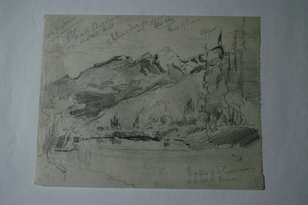
Across the River
https://archives.whyte.org/en/permalink/artifactcoj.03.419
- Date
- c. 1920
- Medium
- graphite on paper
- Catalogue Number
- CoJ.03.419
- Description
- Pencil drawing of landscape with water in foreground and mountains in background.brc: Band of shadows across riverOther cursive writing denotes details and colour scheme.
1 image
- Title
- Across the River
- Date
- c. 1920
- Medium
- graphite on paper
- Dimensions
- 20.0 x 26.0 cm
- Description
- Pencil drawing of landscape with water in foreground and mountains in background.brc: Band of shadows across riverOther cursive writing denotes details and colour scheme.
- Subject
- landscape
- Credit
- Gift of John Rivette, Seymour Arm, 1997
- Catalogue Number
- CoJ.03.419
Images
This material is presented as originally created; it may contain outdated cultural descriptions and
potentially offensive content.
Read more.
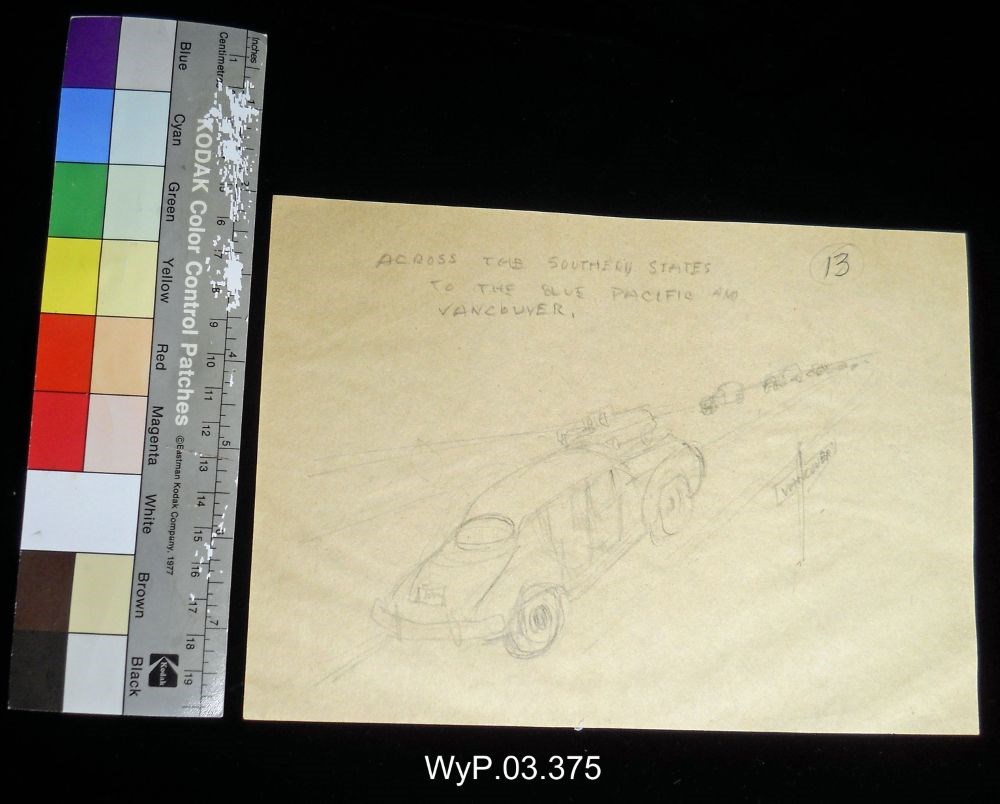
Across the Southern States to the Blue Pacific and Vancouver
https://archives.whyte.org/en/permalink/artifactwyp.03.375
- Date
- 1925 – 1966
- Medium
- graphite on paper
- Catalogue Number
- WyP.03.375
- Description
- Side 1: Pencil drawing of car driving on a highway to the viewer’s right and into the distance. Other more roughly sketched vehicles are in oncoming lanes. A sign to the right of the road reads: ACROSS THE SOUTHERN STATES/ TO THE PACIFIC AND/ VANCOUVERIn the top left corner, the number 13 is circle…
1 image
- Title
- Across the Southern States to the Blue Pacific and Vancouver
- Date
- 1925 – 1966
- Medium
- graphite on paper
- Dimensions
- 14.5 x 21.0 cm
- Description
- Side 1: Pencil drawing of car driving on a highway to the viewer’s right and into the distance. Other more roughly sketched vehicles are in oncoming lanes. A sign to the right of the road reads: ACROSS THE SOUTHERN STATES/ TO THE PACIFIC AND/ VANCOUVERIn the top left corner, the number 13 is circled.Side 2: Pencil drawing of a car driving through a landscape of rolling hills. Mountains are barely visible in the background. This illustration is in a rectangular box. Below this box is a rectangle that is divided into four.
- Subject
- car
- landscape
- Peter Whyte
- drawing
- Credit
- Gift of Catharine Robb Whyte, O. C., Banff, 1975
- Catalogue Number
- WyP.03.375
Images
This material is presented as originally created; it may contain outdated cultural descriptions and
potentially offensive content.
Read more.
[Adams Lookout, Alberta]
https://archives.whyte.org/en/permalink/catalogue23439
- Medium
- Library - Maps and blueprints (unannotated; published)
- Map
- Published Date
- 1962
- Publisher
- Dept. of Mines & Technical Surveys
- Call Number
- NTS
- 83E/10E
- Publisher
- Dept. of Mines & Technical Surveys
- Published Date
- 1962
- Scale
- Scale: 1:50,000
- Subjects
- Adams Lookout
- Alberta
- Notes
- National Topographic System
- Accession Number
- 12000
- Call Number
- NTS
- 83E/10E
- Collection
- Archives Library
This material is presented as originally created; it may contain outdated cultural descriptions and
potentially offensive content.
Read more.
[Adams Lookout, Alberta]
https://archives.whyte.org/en/permalink/catalogue23440
- Medium
- Library - Maps and blueprints (unannotated; published)
- Map
- Published Date
- 1962
- Publisher
- Dept. of Mines and Technical Surveys
- Call Number
- NTS
- 83W/10W
- Publisher
- Dept. of Mines and Technical Surveys
- Published Date
- 1962
- Scale
- Scale: 1:50,000
- Subjects
- Adams Lookout
- Alberta
- Notes
- National Topographic System
- Accession Number
- 12000
- Call Number
- NTS
- 83W/10W
- Collection
- Archives Library
This material is presented as originally created; it may contain outdated cultural descriptions and
potentially offensive content.
Read more.
[Adams Plateau 82M/4 East, B.C.]
https://archives.whyte.org/en/permalink/catalogue23441
- Medium
- Library - Maps and blueprints (unannotated; published)
- Map
- Published Date
- 1961
- Publisher
- Department of Mines and Technical Surveys
- Call Number
- NTS
- 82M/4E
- Publisher
- Department of Mines and Technical Surveys
- Published Date
- 1961
- Physical Description
- 1 map : col
- Scale
- Scale: 1:50,000
- Relief: Contour interval 100 ft.
- Subjects
- Adams Plateau
- British Columbia
- Notes
- National Topographic System
- Accession Number
- 7000
- Call Number
- NTS
- 82M/4E
- Collection
- Archives Library
This material is presented as originally created; it may contain outdated cultural descriptions and
potentially offensive content.
Read more.
[Adams Plateau 82M/4 West, B.C.]
https://archives.whyte.org/en/permalink/catalogue23442
- Medium
- Library - Maps and blueprints (unannotated; published)
- Map
- Published Date
- 1961
- Publisher
- Department of Mines and Technical Surveys
- Call Number
- NTS
- 82M/4W
- Publisher
- Department of Mines and Technical Surveys
- Published Date
- 1961
- Physical Description
- 1 map : col
- Scale
- Scale: 1:50,000
- Relief: Contour interval 100 ft.
- Subjects
- Adams Plateau
- British Columbia
- Notes
- National Topographic System
- Accession Number
- 7000
- Call Number
- NTS
- 82M/4W
- Collection
- Archives Library
This material is presented as originally created; it may contain outdated cultural descriptions and
potentially offensive content.
Read more.
[Adams River 82M/11 East, B.C.]
https://archives.whyte.org/en/permalink/catalogue23443
- Medium
- Library - Maps and blueprints (unannotated; published)
- Map
- Published Date
- 1961
- Publisher
- Dept. of Mines and Technical Surveys
- Call Number
- NTS
- 82M/11E
- Publisher
- Dept. of Mines and Technical Surveys
- Published Date
- 1961
- Physical Description
- 1 map : col
- Scale
- Scale: 1:50,000
- Relief: Contour interval 100 ft.
- Subjects
- Adams River
- British Columbia
- Notes
- National Topographic System
- Accession Number
- 3000
- Call Number
- NTS
- 82M/11E
- Collection
- Archives Library
This material is presented as originally created; it may contain outdated cultural descriptions and
potentially offensive content.
Read more.
[Adams River 82M/11 West, B.C.]
https://archives.whyte.org/en/permalink/catalogue23444
- Medium
- Library - Maps and blueprints (unannotated; published)
- Map
- Published Date
- 1961
- Publisher
- Dept. of Mines and Technical Surveys
- Call Number
- NTS
- 82M/11W
- Publisher
- Dept. of Mines and Technical Surveys
- Published Date
- 1961
- Physical Description
- 1 map : col
- Scale
- Scale: 1:50,000
- Relief: Contour interval 100 ft.
- Subjects
- Adams River
- British Columbia
- Notes
- National Topographic System
- Accession Number
- 3000
- Call Number
- NTS
- 82M/11W
- Collection
- Archives Library
This material is presented as originally created; it may contain outdated cultural descriptions and
potentially offensive content.
Read more.
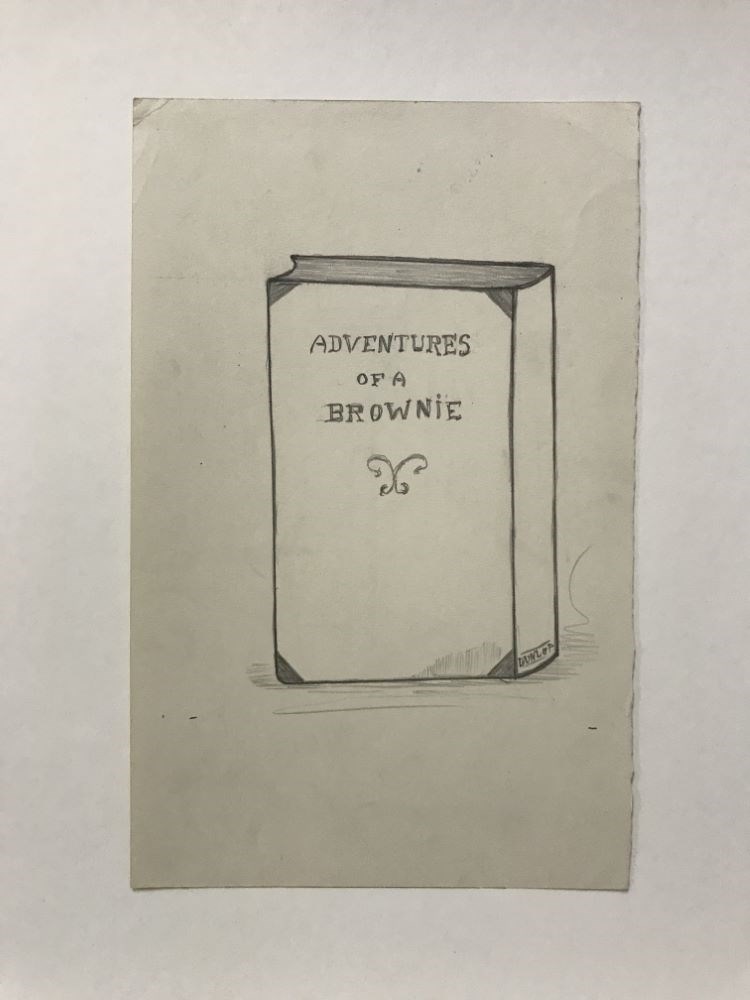
Adventures of a Brownie
https://archives.whyte.org/en/permalink/artifactwyp.03.915
- Date
- 1921
- Medium
- graphite on paper
- Catalogue Number
- WyP.03.915
- Description
- A book standing upright, that has a little shading on the surface that it stands on. On the spine of the book it says “DUNLOP” and on the book cover “ADVENTURES OF A BROWNIE”.verso: a drawing of a coffee table or dining room table. In the TRC it says “Jan 5’/21”
1 image
- Title
- Adventures of a Brownie
- Date
- 1921
- Medium
- graphite on paper
- Dimensions
- 22.8 x 14.5 cm
- Description
- A book standing upright, that has a little shading on the surface that it stands on. On the spine of the book it says “DUNLOP” and on the book cover “ADVENTURES OF A BROWNIE”.verso: a drawing of a coffee table or dining room table. In the TRC it says “Jan 5’/21”
- Credit
- Gift of Catharine Robb Whyte, O. C., Banff, 1979
- Catalogue Number
- WyP.03.915
Images
This material is presented as originally created; it may contain outdated cultural descriptions and
potentially offensive content.
Read more.
Aerochrome Infrared photograph of Banff and surrounding area
https://archives.whyte.org/en/permalink/catalogue24805
- Medium
- Library - Maps and blueprints (unannotated; published)
- Map
- Published Date
- August 1972
- Call Number
- C12-4.22
- Published Date
- August 1972
- Scale
- 1:17,000
- Subjects
- Banff - Aerial Photo
- Notes
- Legend: 12 designated townsite areas
- See: Fig. 1, 2, 3 on reverse side of map
- Call Number
- C12-4.22
- Collection
- Archives Library
This material is presented as originally created; it may contain outdated cultural descriptions and
potentially offensive content.
Read more.