Narrow Results By
- Peter and Catharine Whyte fonds 104
- Bruno Engler fonds 66
- Luxton family fonds 50
- Nicholas Morant fonds 18
- Jim Brewster family fonds 7
- Alpine Club of Canada fonds 6
- Arthur A. Goodsell fonds 6
- Archives General File Collection 5
- Associated Screen News fonds 5
- James Irving McLeod fonds 5
- William Royle fonds 4
- Astley family fonds 2
- Peter Whyte (1905 – 1966, Canadian) 249
- Catharine Robb Whyte, O. C. (1906 – 1979, Canadian) 207
- Engler, Bruno 64
- Whyte, Catharine 41
- Whyte, Peter 17
- Luxton, Norman 16
- Luxton, Eleanor 14
- Carl Clemens Moritz Rungius (1869 – 1959, American) 10
- Walter Joseph Phillips, R. C. A. (1884 – 1963, Canadian) 10
- Alpine Club of Canada 6
- Brewster, Jim 6
- Goodsell, Arthur A. 6
[Rocky Mountains Park]
https://archives.whyte.org/en/permalink/catalogue23187
- Medium
- Library - Maps and blueprints (unannotated; published)
- Map
- Published Date
- 1890
- Publisher
- Dept. of the Interior
- Call Number
- C2-3.1a
- C2-3.1b
- C2-3.1c
- C2-3.1d
- Publisher
- Dept. of the Interior
- Published Date
- 1890
- Scale
- Scale: 1 mile to 1 inch
- Relief: Spot heights
- Subjects
- Rocky Mountains Park
- Notes
- Two duplicates in map room - Accn. 440 and 938, Two photostatic duplicates in map room - Accn. 400, One photostatic duplicate - C2-3.1b
- Accession Number
- 400
- 938
- Call Number
- C2-3.1a
- C2-3.1b
- C2-3.1c
- C2-3.1d
- Collection
- Archives Library
This material is presented as originally created; it may contain outdated cultural descriptions and
potentially offensive content.
Read more.
Cart trail from Calgary to Edmonton
https://archives.whyte.org/en/permalink/catalogue24486
- Medium
- Library - Maps and blueprints (unannotated; published)
- Map
- Published Date
- 1890
- Publisher
- Dept. of the Interior
- Call Number
- C9-7.31
- Publisher
- Dept. of the Interior
- Published Date
- 1890
- Scale
- 1 mile: 2 inches
- Notes
- photostatic copy from Public Archives
- Accession Number
- 675
- Call Number
- C9-7.31
- Collection
- Archives Library
This material is presented as originally created; it may contain outdated cultural descriptions and
potentially offensive content.
Read more.
Morleyville Trail and Cart Trail from Calgary to Edmonton
https://archives.whyte.org/en/permalink/catalogue24488
- Medium
- Library - Maps and blueprints (unannotated; published)
- Map
- Published Date
- 1890
- Publisher
- Dept. of the Interior
- Call Number
- C9-7.32
- Publisher
- Dept. of the Interior
- Published Date
- 1890
- Scale
- 1 mile: 2 inches
- Notes
- photostatic copy from Public Archives
- Accession Number
- 675
- Call Number
- C9-7.32
- Collection
- Archives Library
This material is presented as originally created; it may contain outdated cultural descriptions and
potentially offensive content.
Read more.
Topographical sheet
https://archives.whyte.org/en/permalink/catalogue24646
- Medium
- Library - Maps and blueprints (unannotated; published)
- Map
- Published Date
- 1890
- Publisher
- Dept. of the Interior
- Call Number
- C3-8.6
- Publisher
- Dept. of the Interior
- Published Date
- 1890
- Scale
- Scale: 1:40,000
- Relief: Contour interval 100 ft.
- Subjects
- Castle Mountain
- Notes
- Photostatic copy from Public Archives
- Accession Number
- 675
- Call Number
- C3-8.6
- Collection
- Archives Library
This material is presented as originally created; it may contain outdated cultural descriptions and
potentially offensive content.
Read more.
Topographical sheet
https://archives.whyte.org/en/permalink/catalogue24647
- Medium
- Library - Maps and blueprints (unannotated; published)
- Map
- Published Date
- 1890
- Publisher
- Dept. of the Interior
- Call Number
- C3-8.7
- Publisher
- Dept. of the Interior
- Published Date
- 1890
- Scale
- Scale: 1:40,000
- Relief: Contour interval 100 ft.
- Subjects
- Forty-Mile Creek
- Notes
- Photostatic copy from Public Archives
- Accession Number
- 675
- Call Number
- C3-8.7
- Collection
- Archives Library
This material is presented as originally created; it may contain outdated cultural descriptions and
potentially offensive content.
Read more.
Topographical sheet
https://archives.whyte.org/en/permalink/catalogue24648
- Medium
- Library - Maps and blueprints (unannotated; published)
- Map
- Published Date
- 1890
- Publisher
- Dept. of the Interior
- Call Number
- C3-8.8
- Publisher
- Dept. of the Interior
- Published Date
- 1890
- Scale
- Scale: 1:40,000
- Relief: Contour interval 100 ft.
- Subjects
- Cascade Mountain
- Notes
- Photostatic copy from Public Archives
- Accession Number
- 675
- Call Number
- C3-8.8
- Collection
- Archives Library
This material is presented as originally created; it may contain outdated cultural descriptions and
potentially offensive content.
Read more.
Topographical sheet
https://archives.whyte.org/en/permalink/catalogue24659
- Medium
- Library - Maps and blueprints (unannotated; published)
- Map
- Published Date
- 1890
- Publisher
- Dept. of the Interior
- Call Number
- C3-8.19
- Publisher
- Dept. of the Interior
- Published Date
- 1890
- Scale
- Scale: 1:40,000
- Relief: Contour interval 100 ft.
- Subjects
- Canmore
- Notes
- Photostatic copy from Public Archives
- Accession Number
- 675
- Call Number
- C3-8.19
- Collection
- Archives Library
This material is presented as originally created; it may contain outdated cultural descriptions and
potentially offensive content.
Read more.
Topographical sheet
https://archives.whyte.org/en/permalink/catalogue24660
- Medium
- Library - Maps and blueprints (unannotated; published)
- Map
- Published Date
- 1890
- Publisher
- Dept. of the Interio
- Call Number
- C3-8.20
- Publisher
- Dept. of the Interio
- Published Date
- 1890
- Scale
- Scale: 1:40,000
- Relief: Contour interval 100 ft.
- Subjects
- Gap
- Notes
- Photostatic copy from Public Archives
- Accession Number
- 675
- Call Number
- C3-8.20
- Collection
- Archives Library
This material is presented as originally created; it may contain outdated cultural descriptions and
potentially offensive content.
Read more.
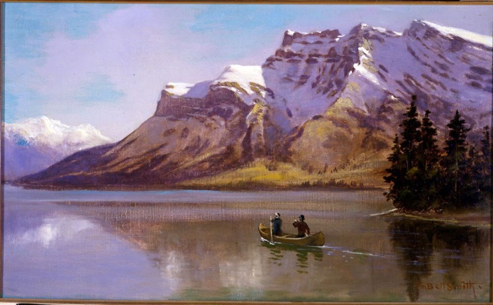
Lake Minnewanka and Mount Inglismaldie
https://archives.whyte.org/en/permalink/artifactbes.02.01
- Date
- 1890
- Medium
- oil on canvas
- Catalogue Number
- BeS.02.01
- Description
- Colour: blue, green. The lower half is a lake with two people in a canoe right of center. A piece of land with evergreens comes out at the right side. The upper half is a mountain range. At the left side in the distance is another range. Above is clear blue sky.This painting was lent to the Winnipe…
1 image
- Title
- Lake Minnewanka and Mount Inglismaldie
- Date
- 1890
- Medium
- oil on canvas
- Dimensions
- 34.0 x 57.0 cm
- Description
- Colour: blue, green. The lower half is a lake with two people in a canoe right of center. A piece of land with evergreens comes out at the right side. The upper half is a mountain range. At the left side in the distance is another range. Above is clear blue sky.This painting was lent to the Winnipeg Art Gallery in 1975 to be included in the exhibition The Railway: A Patron of the Arts in Canada. The exhibition was circulated accross the country for two years.
- Credit
- Purchased from Red River Books, 1968
- Catalogue Number
- BeS.02.01
Images
This material is presented as originally created; it may contain outdated cultural descriptions and
potentially offensive content.
Read more.
- Date
- 1890
- Medium
- oil on canvas
- Catalogue Number
- VhW.02.01
1 image
- Title
- Okanagan Lake
- Date
- 1890
- Medium
- oil on canvas
- Dimensions
- 43.5 x 75 cm
- Subject
- landscape, lake
- architecture, rural
- Credit
- Gift of Esso Resources Ltd., 1980
- Catalogue Number
- VhW.02.01
Images
This material is presented as originally created; it may contain outdated cultural descriptions and
potentially offensive content.
Read more.
Topographical sheet
https://archives.whyte.org/en/permalink/catalogue24649
- Medium
- Library - Maps and blueprints (unannotated; published)
- Map
- Published Date
- 1891
- Publisher
- Dept. of the Interior
- Call Number
- C3-8.9
- Publisher
- Dept. of the Interior
- Published Date
- 1891
- Scale
- Scale: 1:40,000
- Relief: Contour interval 100 ft.
- Subjects
- Mount Aylmer
- Notes
- Photostatic copy from Public Archives
- Accession Number
- 675
- Call Number
- C3-8.9
- Collection
- Archives Library
This material is presented as originally created; it may contain outdated cultural descriptions and
potentially offensive content.
Read more.
Topographical sheet
https://archives.whyte.org/en/permalink/catalogue24650
- Medium
- Library - Maps and blueprints (unannotated; published)
- Map
- Published Date
- 1891
- Publisher
- Dept. of the Interior
- Call Number
- C3-8.10
- Publisher
- Dept. of the Interior
- Published Date
- 1891
- Scale
- Scale: 1:40,000
- Relief: Contour interval 100 ft.
- Subjects
- Devil's Head
- Notes
- Photostatic copy from Public Archives
- Accession Number
- 675
- Call Number
- C3-8.10
- Collection
- Archives Library
This material is presented as originally created; it may contain outdated cultural descriptions and
potentially offensive content.
Read more.
Topographical sheet
https://archives.whyte.org/en/permalink/catalogue24656
- Medium
- Library - Maps and blueprints (unannotated; published)
- Map
- Published Date
- 1891
- Publisher
- Dept. of the Interior
- Call Number
- C3-8.16
- Publisher
- Dept. of the Interior
- Published Date
- 1891
- Scale
- Scale: 1:40,000
- Relief: Contour interval 100 ft.
- Subjects
- End Mountain
- Notes
- Photostatic copy from Public Archives
- Accession Number
- 675
- Call Number
- C3-8.16
- Collection
- Archives Library
This material is presented as originally created; it may contain outdated cultural descriptions and
potentially offensive content.
Read more.
Topographical Sheet
https://archives.whyte.org/en/permalink/catalogue24657
- Medium
- Library - Maps and blueprints (unannotated; published)
- Map
- Published Date
- 1891
- Publisher
- Dept. of the Interior
- Call Number
- C3-8.17
- Publisher
- Dept. of the Interior
- Published Date
- 1891
- Scale
- Scale: 1:40,000
- Relief: Contour interval 100 ft.
- Subjects
- Simpson's Pass
- Notes
- Photostatic copy from Public Archives
- Accession Number
- 675
- Call Number
- C3-8.17
- Collection
- Archives Library
This material is presented as originally created; it may contain outdated cultural descriptions and
potentially offensive content.
Read more.
Topographical sheets
https://archives.whyte.org/en/permalink/catalogue24658
- Medium
- Library - Maps and blueprints (unannotated; published)
- Map
- Published Date
- 1891
- Publisher
- Dept. of the Interior
- Call Number
- C3-8.18
- Publisher
- Dept. of the Interior
- Published Date
- 1891
- Scale
- Scale: 1:40,000
- Relief: Contour interval 100 ft.
- Subjects
- Spray River
- Notes
- Photostatic copy from Public Archives
- Accession Number
- 675
- Call Number
- C3-8.18
- Collection
- Archives Library
This material is presented as originally created; it may contain outdated cultural descriptions and
potentially offensive content.
Read more.
- Medium
- Library - Maps and blueprints (unannotated; published)
- Map
- Published Date
- 1892
- Call Number
- C3-8.23
- Published Date
- 1892
- Subjects
- Rocky and Selkirk Mountains - B.C.
- Notes
- Photostatic copy from Public Archives
- Accession Number
- 675
- Call Number
- C3-8.23
- Collection
- Archives Library
This material is presented as originally created; it may contain outdated cultural descriptions and
potentially offensive content.
Read more.
Topographic Sheet
https://archives.whyte.org/en/permalink/catalogue24642
- Medium
- Library - Maps and blueprints (unannotated; published)
- Map
- Published Date
- 1892
- Publisher
- Dept. of the Interior
- Call Number
- C3-8.2
- Publisher
- Dept. of the Interior
- Published Date
- 1892
- Scale
- Scale: 1:40,000
- Relief: Contour interval 100 ft.
- Subjects
- Baker Creek
- Accession Number
- 675
- Call Number
- C3-8.2
- Collection
- Archives Library
This material is presented as originally created; it may contain outdated cultural descriptions and
potentially offensive content.
Read more.
Topographical sheet
https://archives.whyte.org/en/permalink/catalogue24643
- Medium
- Library - Maps and blueprints (unannotated; published)
- Map
- Published Date
- 1892
- Publisher
- Dept. of the Interior
- Call Number
- C3-8.3
- Publisher
- Dept. of the Interior
- Published Date
- 1892
- Scale
- Scale: 1:40,000
- Relief: Contour interval 100 ft.
- Subjects
- Sawback
- Notes
- Photostatic copy from Public Archives
- Accession Number
- 675
- Call Number
- C3-8.3
- Collection
- Archives Library
This material is presented as originally created; it may contain outdated cultural descriptions and
potentially offensive content.
Read more.
Topographical sheet
https://archives.whyte.org/en/permalink/catalogue24644
- Medium
- Library - Maps and blueprints (unannotated; published)
- Map
- Published Date
- 1892
- Publisher
- Dept. of the Interior
- Call Number
- C3-8.4
- Publisher
- Dept. of the Interior
- Published Date
- 1892
- Scale
- Scale: 1:40,000
- Relief: Contour interval 100 ft.
- Subjects
- Palliser
- Notes
- Photostatic copy from Public Archives
- Accession Number
- 675
- Call Number
- C3-8.4
- Collection
- Archives Library
This material is presented as originally created; it may contain outdated cultural descriptions and
potentially offensive content.
Read more.
Topographical sheet
https://archives.whyte.org/en/permalink/catalogue24645
- Medium
- Library - Maps and blueprints (unannotated; published)
- Map
- Published Date
- 1892
- Publisher
- Dept. of the Interior
- Call Number
- C3-8.5
- Publisher
- Dept. of the Interior
- Published Date
- 1892
- Scale
- Scale: 1:40,000
- Relief: Contour interval 100 ft.
- Subjects
- Eldon
- Notes
- Photostatic copy from Public Archives
- Accession Number
- 675
- Call Number
- C3-8.5
- Collection
- Archives Library
This material is presented as originally created; it may contain outdated cultural descriptions and
potentially offensive content.
Read more.