Narrow Results By
- Nicholas Morant fonds 6
- Luxton family fonds 3
- Ben Gadd fonds 2
- George K. K. (Tommy) Link fonds 2
- Trail Riders of the Canadian Rockies fonds 2
- Archives General File Collection 1
- Arnold Wexler fonds 1
- Arthur Oliver Wheeler fonds 1
- Bert Riggall fonds 1
- Bob Hind fonds 1
- Bob Smith fonds 1
- Brewster Transport Company Ltd. fonds 1
- Catharine Robb Whyte, O. C. (1906 – 1979, Canadian) 171
- Peter Whyte (1905 – 1966, Canadian) 120
- Sitting Wind (1925 – 2002, Canadian) 6
- Alfred Crocker Leighton, R. C. A. (1901 – 1965, Canadian) 3
- Andreas Roth 3
- Belmore Browne (1880 – 1954, American) 3
- Carl Clemens Moritz Rungius (1869 – 1959, American) 3
- Earl F. Spencer 3
- Henry George Glyde (1906 – 1998, Canadian) 3
- Aldro T. Hibbard (1886 – 1972, American) 2
- Gadd, Ben 2
- Herbert C. Hahn (1907 – , American) 2
Central British Columbia
https://archives.whyte.org/en/permalink/catalogue24534
- Medium
- Library - Maps and blueprints (unannotated; published)
- Map
- Published Date
- 1940
- Publisher
- Dept. of Lands, B.C.
- Call Number
- C10-6.5
- Publisher
- Dept. of Lands, B.C.
- Published Date
- 1940
- Scale
- Scale: 1:1,000,000
- Subjects
- Central British Columbia
- Accession Number
- 540
- 3349?
- Call Number
- C10-6.5
- Collection
- Archives Library
This material is presented as originally created; it may contain outdated cultural descriptions and
potentially offensive content.
Read more.
Preliminary map: George Creek, Alberta
https://archives.whyte.org/en/permalink/catalogue24729
- Medium
- Library - Book (including soft-cover and pamphlets)
- Map
- Published Date
- 1940
- Author
- MacKay, B.R.
- Publisher
- Ottawa: Mines and Geological Branch
- Call Number
- C7-2.13, C7-2.13a
- Author
- MacKay, B.R.
- Publisher
- Ottawa: Mines and Geological Branch
- Published Date
- 1940
- Physical Description
- 2 maps
- Scale
- Scale: 1 inch = 1/2 mile
- Notes
- Paper 40-17
- Accession Number
- 5000
- Call Number
- C7-2.13, C7-2.13a
- Collection
- Archives Library
This material is presented as originally created; it may contain outdated cultural descriptions and
potentially offensive content.
Read more.
Geological survey [Keremeos - Similkameen District]
https://archives.whyte.org/en/permalink/catalogue24738
- Medium
- Library - Book (including soft-cover and pamphlets)
- Map
- Published Date
- 1940
- Publisher
- Dept. of Mines and Resources
- Call Number
- C7-3.6
- Publisher
- Dept. of Mines and Resources
- Published Date
- 1940
- Physical Description
- 1 map : col
- Scale
- Scale: 1 inch to 1 mile
- Relief: Contour interval 100 ft.
- Subjects
- Keremeos - Similkameen District
- Accession Number
- 673
- Call Number
- C7-3.6
- Collection
- Archives Library
This material is presented as originally created; it may contain outdated cultural descriptions and
potentially offensive content.
Read more.
Classical Lands of the Mediterranean
https://archives.whyte.org/en/permalink/catalogue24862
- Medium
- Library - Maps and blueprints (unannotated; published)
- Map
- Published Date
- 1940
- Publisher
- National Geographic Society
- Call Number
- C13-12.14
- Publisher
- National Geographic Society
- Published Date
- 1940
- Scale
- Scale: 35 miles to 1 inch
- Relief: Bench mark
- Subjects
- Europe - Southern
- Accession Number
- 495
- Call Number
- C13-12.14
- Collection
- Archives Library
This material is presented as originally created; it may contain outdated cultural descriptions and
potentially offensive content.
Read more.
Map showing how population of Europe is divided nationally and in language groups
https://archives.whyte.org/en/permalink/catalogue21534
- Medium
- Library - Maps and blueprints (unannotated; published)
- Map
- Published Date
- 1940
- Call Number
- C13-12.5
- Published Date
- 1940
- Subjects
- Europe
- Notes
- "Europe's Racial Tangle"
- Europe's Jewish Population
- Accession Number
- 400
- Call Number
- C13-12.5
- Collection
- Archives Library
This material is presented as originally created; it may contain outdated cultural descriptions and
potentially offensive content.
Read more.
[Banff - Sketch plan of Banff townsite]
https://archives.whyte.org/en/permalink/catalogue23259
- Medium
- Library - Maps and blueprints (unannotated; published)
- Map
- Published Date
- 1940
- Publisher
- Department of Mines and Resources
- Call Number
- C4-1.5
- Publisher
- Department of Mines and Resources
- Published Date
- 1940
- Physical Description
- 1 map : black and white
- Scale
- Scale: 400' = 1"
- Subjects
- Banff townsite
- Notes
- Duplicate - Map Room - Accn. 1038, 2933
- Accession Number
- 1161
- 1038
- 2933
- Call Number
- C4-1.5
- Collection
- Archives Library
This material is presented as originally created; it may contain outdated cultural descriptions and
potentially offensive content.
Read more.
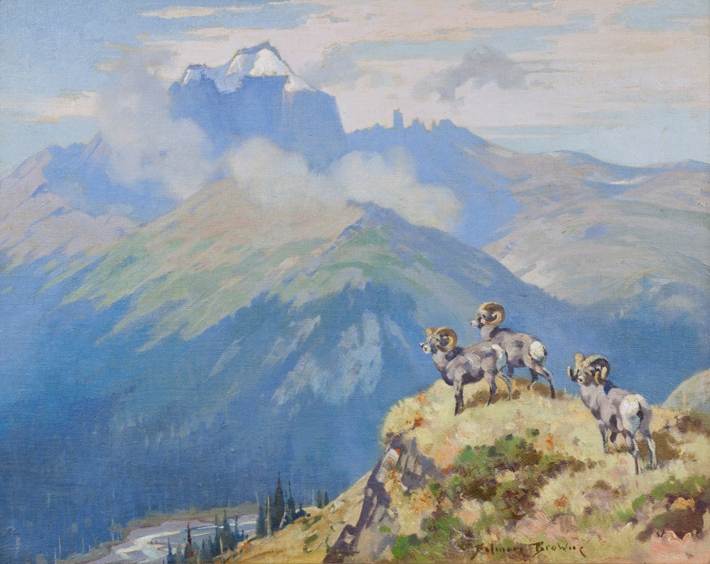
Mount Saskatchewan
https://archives.whyte.org/en/permalink/artifactbwb.02.08
- Date
- 1940
- Medium
- oil on canvas
- Catalogue Number
- BwB.02.08
- Description
- Three Rams are standing on the edge of a cliff looking over the edge out at the mountains in the background. The mountains in the background have many clouds around them and the sky is also very cloudy. There are trees down close to the bottom of the image in the center and the Rams are facing the …
1 image
- Title
- Mount Saskatchewan
- Date
- 1940
- Medium
- oil on canvas
- Dimensions
- 50.0 x 51.0 cm
- Description
- Three Rams are standing on the edge of a cliff looking over the edge out at the mountains in the background. The mountains in the background have many clouds around them and the sky is also very cloudy. There are trees down close to the bottom of the image in the center and the Rams are facing the left side of the painting with their backs to the right.
- Credit
- Gift of J. Monroe Thorington, Philadelphia, USA, 1979
- Catalogue Number
- BwB.02.08
Images
This material is presented as originally created; it may contain outdated cultural descriptions and
potentially offensive content.
Read more.
[Moose Mountain 82 J/15 West - Alberta]
https://archives.whyte.org/en/permalink/catalogue23744
- Medium
- Library - Maps and blueprints (unannotated; published)
- Map
- Published Date
- 1941
- Publisher
- Dept. of Mines and Technical Surveys
- Call Number
- NTS
- 82J/15W
- Publisher
- Dept. of Mines and Technical Surveys
- Published Date
- 1941
- Physical Description
- Black and White
- Scale
- Scale: 1:50,000
- Relief: Contour interval 100'
- Notes
- National Topographic System
- Call Number
- NTS
- 82J/15W
- Collection
- Archives Library
This material is presented as originally created; it may contain outdated cultural descriptions and
potentially offensive content.
Read more.
[British Columbia, Highways] Alberta Motor Association
https://archives.whyte.org/en/permalink/catalogue24512
- Medium
- Library - Maps and blueprints (unannotated; published)
- Map
- Published Date
- 1941
- Call Number
- C10-1.1
- Published Date
- 1941
- Scale
- 1 inch-40 miles
- Subjects
- British Columbia
- Highways
- Notes
- Tourist information for 1941 on reverse side of map
- Accession Number
- 400
- Call Number
- C10-1.1
- Collection
- Archives Library
This material is presented as originally created; it may contain outdated cultural descriptions and
potentially offensive content.
Read more.
Preliminary map : Bighorn River, Alberta
https://archives.whyte.org/en/permalink/catalogue24728
- Medium
- Library - Book (including soft-cover and pamphlets)
- Map
- Published Date
- 1941
- Author
- MacKay, B.R.
- Publisher
- Ottawa: Geological Survey of Canada
- Call Number
- C7-2.12, C7-2.12a
- Author
- MacKay, B.R.
- Publisher
- Ottawa: Geological Survey of Canada
- Published Date
- 1941
- Physical Description
- 2 maps
- Scale
- Sccale: 2 inches = 1 mile
- Notes
- Map 41-9
- Accession Number
- 5000
- Call Number
- C7-2.12, C7-2.12a
- Collection
- Archives Library
This material is presented as originally created; it may contain outdated cultural descriptions and
potentially offensive content.
Read more.
Geological survey [Okanagan Falls - Similkameen & Osoyoos Dist.]
https://archives.whyte.org/en/permalink/catalogue24737
- Medium
- Library - Book (including soft-cover and pamphlets)
- Map
- Published Date
- 1941
- Publisher
- Dept. of Mines and Resources
- Call Number
- C7-3.5
- Publisher
- Dept. of Mines and Resources
- Published Date
- 1941
- Physical Description
- 1 map : col
- Scale
- Scale: 1 inch to 1 mile
- Relief: Contour interval 100 ft.
- Accession Number
- 673
- Call Number
- C7-3.5
- Collection
- Archives Library
This material is presented as originally created; it may contain outdated cultural descriptions and
potentially offensive content.
Read more.
[United States] And neighbouring Canadian Provinces
https://archives.whyte.org/en/permalink/catalogue24809
- Medium
- Library - Maps and blueprints (unannotated; published)
- Map
- Published Date
- 1941
- Publisher
- National Geographic Society
- Call Number
- C13-1.1(a)
- Publisher
- National Geographic Society
- Published Date
- 1941
- Scale
- 1:2,500,000
- Subjects
- North Western United States
- Accession Number
- 400
- Call Number
- C13-1.1(a)
- Collection
- Archives Library
This material is presented as originally created; it may contain outdated cultural descriptions and
potentially offensive content.
Read more.
Soil rating map of Rosebud and portion of Banff sheets
https://archives.whyte.org/en/permalink/catalogue24878
- Medium
- Library - Maps and blueprints (unannotated; published)
- Map
- Published Date
- 1941
- Publisher
- Edmonton : U. of A.
- Call Number
- C14-2.11
- Responsibility
- prepared by Dept. of Soils, University of Alberta in cooperation with Experimental Farm Service, Canada Dept. of Agriculture
- Publisher
- Edmonton : U. of A.
- Published Date
- 1941
- Physical Description
- 1 map
- Scale
- 1 inch = 6 miles
- Subjects
- Soils - Banff region
- Accession Number
- 13,000
- Call Number
- C14-2.11
- Collection
- Archives Library
This material is presented as originally created; it may contain outdated cultural descriptions and
potentially offensive content.
Read more.
Mountain Goats and Mount Assiniboine
https://archives.whyte.org/en/permalink/artifactbwb.02.06
- Date
- 1941
- Medium
- oil on canvas
- Catalogue Number
- BwB.02.06
- Description
- General colour: blue, green, grey. Two mountain goats look over a cliff at right into misty valley below. A hawk flys in the cloud lower left. In the upper left is a mountain. The peak is up center and is slightly behind a cloud. The sky is bright yellow.
1 image
- Title
- Mountain Goats and Mount Assiniboine
- Date
- 1941
- Medium
- oil on canvas
- Dimensions
- 45.0 x 59.0 cm
- Description
- General colour: blue, green, grey. Two mountain goats look over a cliff at right into misty valley below. A hawk flys in the cloud lower left. In the upper left is a mountain. The peak is up center and is slightly behind a cloud. The sky is bright yellow.
- Credit
- Gift of J. Monroe Thorington, Philadelphia, USA, 1973
- Catalogue Number
- BwB.02.06
Images

This material is presented as originally created; it may contain outdated cultural descriptions and
potentially offensive content.
Read more.
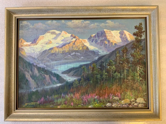
Athabasca Glacier, Columbia Icefields
https://archives.whyte.org/en/permalink/artifactrta.02.01
- Artist
- Andreas Roth
- Date
- 1941
- Medium
- oil paint on board
- Catalogue Number
- RtA.02.01
- Description
- Mountain landscape with mountains topped with glaciers in background. Glacial tongue with river leading away from it in the centre of the painting. Wildflowers and trees in foreground. Bottom left corner is “Andreas Roth. 1941”
1 image
- Artist
- Andreas Roth
- Title
- Athabasca Glacier, Columbia Icefields
- Date
- 1941
- Medium
- oil paint on board
- Dimensions
- 43.5 x 62.0 cm
- Description
- Mountain landscape with mountains topped with glaciers in background. Glacial tongue with river leading away from it in the centre of the painting. Wildflowers and trees in foreground. Bottom left corner is “Andreas Roth. 1941”
- Credit
- Gift of Robert Crosby Family, Banff, 1998
- Catalogue Number
- RtA.02.01
Images
This material is presented as originally created; it may contain outdated cultural descriptions and
potentially offensive content.
Read more.
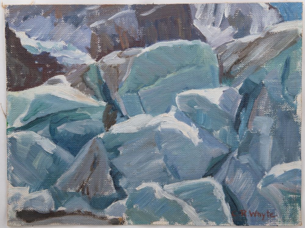
Toe of Athabasca Glacier
https://archives.whyte.org/en/permalink/artifactwyc.01.192
- Date
- 1941
- Medium
- oil on canvas
- Catalogue Number
- WyC.01.192
- Description
- Toe of Athabasca Glacier.
1 image
- Title
- Toe of Athabasca Glacier
- Date
- 1941
- Medium
- oil on canvas
- Dimensions
- 22.8 x 28.0 cm
- Description
- Toe of Athabasca Glacier.
- Credit
- Gift of Catharine Robb Whyte, O. C., Banff, 1979
- Catalogue Number
- WyC.01.192
Images

This material is presented as originally created; it may contain outdated cultural descriptions and
potentially offensive content.
Read more.
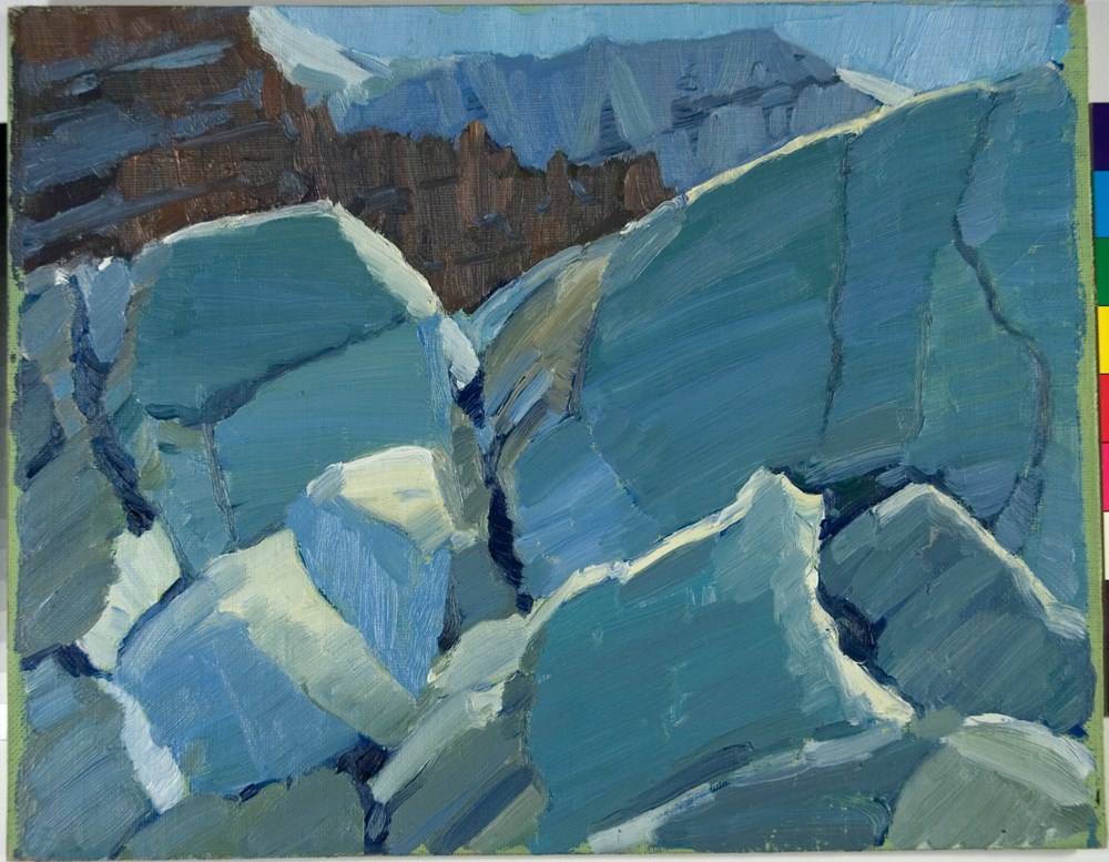
Ice Blocks, Athabasca Glacier
https://archives.whyte.org/en/permalink/artifactwyp.01.159
- Date
- 1941
- Medium
- oil on canvas
- Catalogue Number
- WyP.01.159
- Description
- The canvas is dominated by huge iceblocks in grey, blue, white and brown. Part of the rock wall and Athabasca Glacier show up in the ochre and white peaks, very little sky in mid-and right-hand corner.
1 image
- Title
- Ice Blocks, Athabasca Glacier
- Date
- 1941
- Medium
- oil on canvas
- Dimensions
- 27.7 x 35.4 cm
- Description
- The canvas is dominated by huge iceblocks in grey, blue, white and brown. Part of the rock wall and Athabasca Glacier show up in the ochre and white peaks, very little sky in mid-and right-hand corner.
- Credit
- Gift of Catharine Robb Whyte, O. C., Banff, 1979
- Catalogue Number
- WyP.01.159
- Notes
- Artistry Revealed: Peter Whyte, Catharine Robb Whyte and Their Contemporaries; June 17, 2018 to October 21, 2018
Images
This material is presented as originally created; it may contain outdated cultural descriptions and
potentially offensive content.
Read more.
Athabasca Glacier Toe
https://archives.whyte.org/en/permalink/artifactwyc.01.001
- Date
- 1941
- Medium
- oil on canvas
- Catalogue Number
- WyC.01.001
- Description
- Grey and white coloured rocks, top left of picture is brown and white .
1 image
- Title
- Athabasca Glacier Toe
- Date
- 1941
- Medium
- oil on canvas
- Dimensions
- 21.0 x 27.7 cm
- Description
- Grey and white coloured rocks, top left of picture is brown and white .
- Credit
- Gift of Catharine Robb Whyte, O. C., Banff, 1979
- Catalogue Number
- WyC.01.001
Images
This material is presented as originally created; it may contain outdated cultural descriptions and
potentially offensive content.
Read more.
Cascade Development Sketch Plan of the Ghost River Diversion
https://archives.whyte.org/en/permalink/catalogue23361
- Medium
- Library - Maps and blueprints (unannotated; published)
- Map
- Published Date
- March 31, 1941
- Call Number
- C5-6.27(a)
- Published Date
- March 31, 1941
- Scale
- 1" - 1000'
- Subjects
- Calgary Power Co. Ltd.
- Hydrology
- Notes
- A sketch plan showing approximate surface features of country between Ghost River and Lake Minnewanka
- Accession Number
- 3079
- Call Number
- C5-6.27(a)
- Collection
- Archives Library
This material is presented as originally created; it may contain outdated cultural descriptions and
potentially offensive content.
Read more.
Canal topography from Lake Minnewanka to the sink.
https://archives.whyte.org/en/permalink/catalogue23362
- Medium
- Library - Maps and blueprints (unannotated; published)
- Map
- Published Date
- July 16, 1941 (revised August 8, 1941)
- Call Number
- C5-6.27(b)
- Published Date
- July 16, 1941 (revised August 8, 1941)
- Scale
- 1" = 100'
- Subjects
- Calgary Power Co. Ltd.
- Hydrology
- Notes
- (rolled on top of map case)
- Accession Number
- 3079
- Call Number
- C5-6.27(b)
- Collection
- Archives Library
This material is presented as originally created; it may contain outdated cultural descriptions and
potentially offensive content.
Read more.