Narrow Results By
Races of Europe
https://archives.whyte.org/en/permalink/catalogue21535
- Medium
- Library - Maps and blueprints (unannotated; published)
- Map
- Published Date
- 1919
- Publisher
- National Geographic Society
- Call Number
- C13-12.5(a)
- Publisher
- National Geographic Society
- Published Date
- 1919
- Subjects
- Europe
- Accession Number
- 400
- Call Number
- C13-12.5(a)
- Collection
- Archives Library
This material is presented as originally created; it may contain outdated cultural descriptions and
potentially offensive content.
Read more.
Map showing the northern paortion of Vancouver Island
https://archives.whyte.org/en/permalink/catalogue24531
- Medium
- Library - Maps and blueprints (unannotated; published)
- Map
- Published Date
- 1919
- Publisher
- Dept. of Lands/Honourable T.D. Pattullo. J.E. Umbach Surveyor General
- Call Number
- C10-5.1
- Publisher
- Dept. of Lands/Honourable T.D. Pattullo. J.E. Umbach Surveyor General
- Published Date
- 1919
- Scale
- Scale: 4 miles - 1 inch
- Subjects
- British Columbia
- Vancouver Island
- Accession Number
- 400
- Call Number
- C10-5.1
- Collection
- Archives Library
This material is presented as originally created; it may contain outdated cultural descriptions and
potentially offensive content.
Read more.
Map of Waterton Lakes National Park, Alberta/from photographic surveys by M.P. Bridgland and A.O. Wheeler
https://archives.whyte.org/en/permalink/catalogue23213
- Medium
- Library - Maps and blueprints (unannotated; published)
- Map
- Published Date
- 1918
- Publisher
- Ottawa: Surveyor General's Office
- Call Number
- C2-6.2e
- Publisher
- Ottawa: Surveyor General's Office
- Published Date
- 1918
- Physical Description
- 1 map : col
- Scale
- Scale: 1:100,00
- Accession Number
- 4008
- Call Number
- C2-6.2e
- Collection
- Archives Library
This material is presented as originally created; it may contain outdated cultural descriptions and
potentially offensive content.
Read more.
[Wildermere, Southern B.C.]
https://archives.whyte.org/en/permalink/catalogue24517
- Medium
- Library - Maps and blueprints (unannotated; published)
- Map
- Published Date
- 1918
- Publisher
- Department of Mines
- Call Number
- C10-2.1
- Publisher
- Department of Mines
- Published Date
- 1918
- Physical Description
- 1 map : col
- Scale
- Scale: 1:125,000
- Relief: Contour interval 200 ft.
- Subjects
- British Columbia
- Windermere
- Notes
- Duplicate = C3-4.1
- Accession Number
- 400
- Call Number
- C10-2.1
- Collection
- Archives Library
This material is presented as originally created; it may contain outdated cultural descriptions and
potentially offensive content.
Read more.
- Date
- 1918
- Medium
- graphite on paper
- Catalogue Number
- WyC.03.243
- Description
- shaded bowl
1 image
- Title
- Untitled
- Date
- 1918
- Medium
- graphite on paper
- Dimensions
- 24.0 x 16.0 cm
- Description
- shaded bowl
- Subject
- bowl
- Credit
- Gift of Catharine Robb Whyte, O. C., Banff, 1979
- Catalogue Number
- WyC.03.243
Images

This material is presented as originally created; it may contain outdated cultural descriptions and
potentially offensive content.
Read more.
- Medium
- Library - Maps and blueprints (unannotated; published)
- Map
- Published Date
- 1917
- Publisher
- Dept. of the Interior
- Call Number
- C4-1.6
- Publisher
- Dept. of the Interior
- Published Date
- 1917
- Scale
- Scale: 250' to 1 inch
- Subjects
- Banff - Villa lot section
- Notes
- Townsite map
- Duplicate in Map Room - Accn. 118, 30,000
- Accession Number
- 20
- 118
- 30,000
- Call Number
- C4-1.6
- Collection
- Archives Library
This material is presented as originally created; it may contain outdated cultural descriptions and
potentially offensive content.
Read more.
Map of central part of Jasper from surveys by M.P. Bridgland
https://archives.whyte.org/en/permalink/catalogue24294
- Medium
- Library - Maps and blueprints (unannotated; published)
- Map
- Published Date
- 1917
- Publisher
- Department of the Interior
- Call Number
- C2-2.1
- Responsibility
- from surveys by M. P. Bridgland
- Publisher
- Department of the Interior
- Published Date
- 1917
- Physical Description
- 6 sheets : col
- Scale
- Scale: 1.014 in. = 1 mile
- Relief: Contour interval: 100 ft.
- Subjects
- Jasper National Park
- Accession Number
- 512
- 718
- Call Number
- C2-2.1
- Collection
- Archives Library
This material is presented as originally created; it may contain outdated cultural descriptions and
potentially offensive content.
Read more.
[Northern Alberta]
https://archives.whyte.org/en/permalink/catalogue24420
- Medium
- Library - Maps and blueprints (unannotated; published)
- Map
- Published Date
- 1917
- Publisher
- Dept. of the Interior
- Call Number
- C9-4.1
- Publisher
- Dept. of the Interior
- Published Date
- 1917
- Physical Description
- 1 map : col
- Scale
- Scale: 12 1/2 miles: 1 inch
- Subjects
- Northern Alberta
- Accession Number
- 478
- Call Number
- C9-4.1
- Collection
- Archives Library
This material is presented as originally created; it may contain outdated cultural descriptions and
potentially offensive content.
Read more.
Map of the Ominecca and Finlay River Basins
https://archives.whyte.org/en/permalink/catalogue24527
- Medium
- Library - Maps and blueprints (unannotated; published)
- Map
- Published Date
- 1917
- Publisher
- Surveyor-General's Office, Victoria, B.C.
- Call Number
- C10-3.5
- Publisher
- Surveyor-General's Office, Victoria, B.C.
- Published Date
- 1917
- Scale
- Scale: 5 miles - 1 inch
- Subjects
- Northern British Columbia
- Accession Number
- 400
- Call Number
- C10-3.5
- Collection
- Archives Library
This material is presented as originally created; it may contain outdated cultural descriptions and
potentially offensive content.
Read more.
[British Columbia Forestry] Map showing forest stand types
https://archives.whyte.org/en/permalink/catalogue24537
- Medium
- Library - Maps and blueprints (unannotated; published)
- Map
- Published Date
- 1917
- Publisher
- Commission of Conservation Can.
- Call Number
- C10-9.1
- Publisher
- Commission of Conservation Can.
- Published Date
- 1917
- Scale
- Scale: 25 miles to the inch
- Subjects
- British Columbia
- Forestry
- Notes
- Accompanies "Forests of British Columbia" by H.N. Whitford 04.1/Wh
- 1 duplicate
- Accession Number
- 400
- Call Number
- C10-9.1
- Collection
- Archives Library
This material is presented as originally created; it may contain outdated cultural descriptions and
potentially offensive content.
Read more.
[Boundary Between Alberta and B.C.]
https://archives.whyte.org/en/permalink/catalogue24665
- Medium
- Library - Maps and blueprints (unannotated; published)
- Map
- Published Date
- 1917
- Call Number
- C3-9.17, -9.18
- Published Date
- 1917
- Scale
- Scale: 1:62,500
- Relief: Contour interval 100 ft.
- Series
- Sheet #17, Sheet #18
- Notes
- Duplicate in Boundary Atlas #2
- Accession Number
- 718
- Call Number
- C3-9.17, -9.18
- Collection
- Archives Library
This material is presented as originally created; it may contain outdated cultural descriptions and
potentially offensive content.
Read more.
[Boundary Between Alta. and B.C.]
https://archives.whyte.org/en/permalink/catalogue24666
- Medium
- Library - Maps and blueprints (unannotated; published)
- Map
- Published Date
- 1917
- Call Number
- C3-9.18A
- Published Date
- 1917
- Scale
- Scale: 1:25,000
- Relief: Contour interval 100 ft.
- Series
- Sheet #18A
- Notes
- Duplicate in Boundary Atlas #2
- Accession Number
- 718
- Call Number
- C3-9.18A
- Collection
- Archives Library
This material is presented as originally created; it may contain outdated cultural descriptions and
potentially offensive content.
Read more.
[Boundary Between Alta. and B.C.]
https://archives.whyte.org/en/permalink/catalogue24668
- Medium
- Library - Maps and blueprints (unannotated; published)
- Map
- Published Date
- 1917
- Call Number
- C3-9.29
- Published Date
- 1917
- Scale
- Scale: 1:62,500
- Relief: Contour interval 100 ft.
- Series
- Sheet #29
- Notes
- Duplicate in Boundary Atlas #3
- Accession Number
- 718
- Call Number
- C3-9.29
- Collection
- Archives Library
This material is presented as originally created; it may contain outdated cultural descriptions and
potentially offensive content.
Read more.
[Boundary Between Alta. & B.C.]
https://archives.whyte.org/en/permalink/catalogue24669
- Medium
- Library - Maps and blueprints (unannotated; published)
- Map
- Published Date
- 1917
- Call Number
- C3-9.29A, -9.29B
- Published Date
- 1917
- Scale
- Scale: 1:25,000
- Relief: Contour interval 100 ft.
- Series
- Sheets #29A & 29B
- Notes
- Duplicate in Boundary Atlas #3
- Call Number
- C3-9.29A, -9.29B
- Collection
- Archives Library
This material is presented as originally created; it may contain outdated cultural descriptions and
potentially offensive content.
Read more.
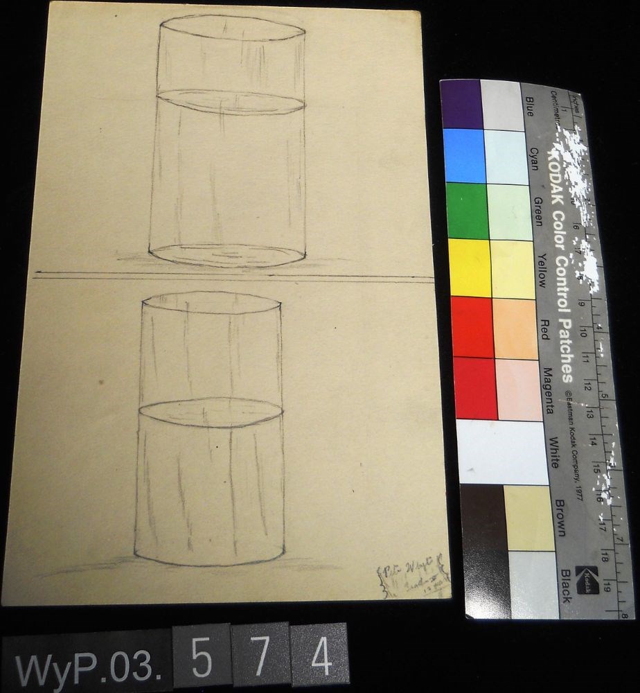
- Date
- 1917
- Medium
- graphite on paper
- Catalogue Number
- WyP.03.574
- Description
- Pencil sketch of two nearly identical transparent cylinders with a transparent liquid in them. They are vertically arranged and a horizontal line cuts the page in half between the two drawings. Signed Pete Whyte/ Grade V or VI (difficult to read/ 12 years
1 image
- Title
- Untitled
- Date
- 1917
- Medium
- graphite on paper
- Dimensions
- 22.5 x 15.1 cm
- Description
- Pencil sketch of two nearly identical transparent cylinders with a transparent liquid in them. They are vertically arranged and a horizontal line cuts the page in half between the two drawings. Signed Pete Whyte/ Grade V or VI (difficult to read/ 12 years
- Credit
- Gift of Catharine Robb Whyte, O. C., Banff, 1979
- Catalogue Number
- WyP.03.574
Images
This material is presented as originally created; it may contain outdated cultural descriptions and
potentially offensive content.
Read more.
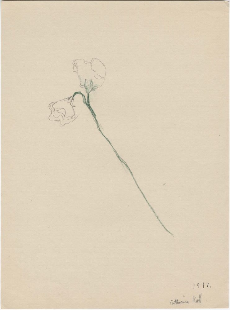
- Date
- 1917
- Medium
- coloured graphite; graphite on paper
- Catalogue Number
- WyC.03.092
- Description
- two flowers on a stem
1 image
- Title
- Untitled
- Date
- 1917
- Medium
- coloured graphite; graphite on paper
- Dimensions
- 30.5 x 23.0 cm
- Description
- two flowers on a stem
- Subject
- flower
- Credit
- Gift of Catharine Robb Whyte, O. C., Banff, 1979
- Catalogue Number
- WyC.03.092
Images
This material is presented as originally created; it may contain outdated cultural descriptions and
potentially offensive content.
Read more.
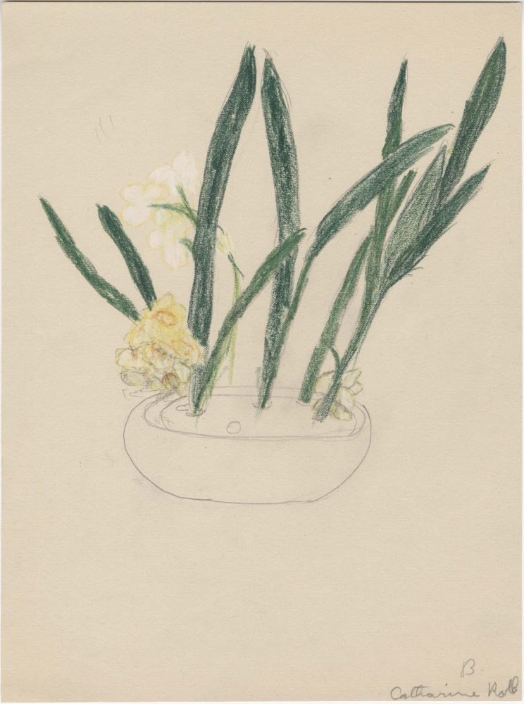
- Date
- 1917
- Medium
- coloured graphite; graphite on paper
- Catalogue Number
- WyC.03.110
- Description
- yellow and white flowers in a wide low Ikebana
1 image
- Title
- Untitled
- Date
- 1917
- Medium
- coloured graphite; graphite on paper
- Dimensions
- 30.5 x 23.0 cm
- Description
- yellow and white flowers in a wide low Ikebana
- Credit
- Gift of Catharine Robb Whyte, O. C., Banff, 1979
- Catalogue Number
- WyC.03.110
Images
This material is presented as originally created; it may contain outdated cultural descriptions and
potentially offensive content.
Read more.
Homestead map of Manitoba, Saskatchewan, and Alberta
https://archives.whyte.org/en/permalink/catalogue24576
- Medium
- Library - Maps and blueprints (unannotated; published)
- Map
- Published Date
- 1916
- Publisher
- Dept. of the Interior
- Call Number
- C11-6.1(a)
- Publisher
- Dept. of the Interior
- Published Date
- 1916
- Scale
- 35 miles to 1 inch
- Subjects
- Canada - Prairie Region
- Notes
- Shows the number of quarter sections available for homestead entry in each township
- Accession Number
- 576
- Call Number
- C11-6.1(a)
- Collection
- Archives Library
This material is presented as originally created; it may contain outdated cultural descriptions and
potentially offensive content.
Read more.
[Boundary Between Alberta and B.C.]
https://archives.whyte.org/en/permalink/catalogue24662
- Medium
- Library - Maps and blueprints (unannotated; published)
- Map
- Published Date
- 1916
- Edition
- Sheet #12
- Call Number
- C3-9.13
- Edition
- Sheet #12
- Published Date
- 1916
- Scale
- Scale: 1:62,500
- Relief: Contour interval 100 ft.
- Series
- Sheet #12
- Notes
- 2 duplicates in Map Room
- 2 photostat copies showing outline of Mt. Assiniboine Provincial Park
- Duplicate in Boundary Atlas #1
- Accession Number
- 44
- 400
- 3349
- 2949
- Call Number
- C3-9.13
- Collection
- Archives Library
This material is presented as originally created; it may contain outdated cultural descriptions and
potentially offensive content.
Read more.
[Boundary Between Alberta and B.C.]
https://archives.whyte.org/en/permalink/catalogue24664
- Medium
- Library - Maps and blueprints (unannotated; published)
- Map
- Published Date
- 1916
- Call Number
- C3-9.15
- Published Date
- 1916
- Scale
- Scale: 1:62,500
- Relief: Contour interval 100 ft.
- Series
- Sheet #15
- Notes
- Duplicate in Map Room
- Duplicate in Boundary Atlas #1
- Accession Number
- 400
- Call Number
- C3-9.15
- Collection
- Archives Library
This material is presented as originally created; it may contain outdated cultural descriptions and
potentially offensive content.
Read more.