Narrow Results By
- Luxton family fonds 8
- Alpine Club of Canada fonds 6
- Underwood and Underwood Publishers fonds 6
- Caroline Hinman fonds 5
- Peter and Catharine Whyte fonds 5
- Kidney family fonds 4
- Archives General File Collection 3
- Dorothy Cranstone fonds 3
- Jim Brewster family fonds 3
- Moore family fonds 3
- Nicholas Morant fonds 3
- Parks Canada fonds 3
Lake St. John
https://archives.whyte.org/en/permalink/descriptions1825
- Part Of
- Lillian Gest fonds
- Scope & Content
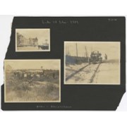
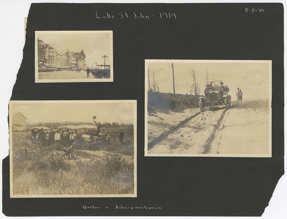
- File pertains to loose pages from an album depicting a canoe trip in the Lac St. John region of Quebec in 1919. Includes scenes of motorcar transportation, camps, canoeing, scenic views, rivers, lakes, fishing, and unidentified people.
- Date Range
- 1919
- Reference Code
- V225 / II / C / ii / b / PD - 1
- Description Level
- 5 / File
- GMD
- Album
- Photograph print
1 image
1 Electronic Resource
- Part Of
- Lillian Gest fonds
- Description Level
- 5 / File
- Fonds Number
- M67 / S36 / V225
- Series
- II.C. Activities / photography
- Sous-Fonds
- V225
- Sub-Series
- ii.b. Photograph material / photograph album
- Accession Number
- 5142
- Reference Code
- V225 / II / C / ii / b / PD - 1
- Date Range
- 1919
- Physical Description
- 1 album (76 photographs : b&w ; 10.5 x 8 cm)
- History / Biographical
- See fonds level description
- Scope & Content
- File pertains to loose pages from an album depicting a canoe trip in the Lac St. John region of Quebec in 1919. Includes scenes of motorcar transportation, camps, canoeing, scenic views, rivers, lakes, fishing, and unidentified people.
- Notes
- Album pages were also accompanied by a Document consisting of the front half of a mailing envelope addressed to Lillian Gest - not scanned.
- Name Access
- Gest, Lillian
- Subject Access
- Activities
- Boats
- Camps
- Camping
- Canoes and canoeing
- Family and personal life
- Fishing
- Scenery
- Travel
- Geographic Access
- Quebec
- Canada
- Access Restrictions
- Microfilm copy available for reference use by appointment only.
- Language
- English
- Conservation
- Avoid further handling of file.
- Title Source
- Title based on contents of file
- Processing Status
- Processed
Electronic Resources
Images
This material is presented as originally created; it may contain outdated cultural descriptions and
potentially offensive content.
Read more.
Map showing the northern paortion of Vancouver Island
https://archives.whyte.org/en/permalink/catalogue24531
- Medium
- Library - Maps and blueprints (unannotated; published)
- Map
- Published Date
- 1919
- Publisher
- Dept. of Lands/Honourable T.D. Pattullo. J.E. Umbach Surveyor General
- Call Number
- C10-5.1
- Publisher
- Dept. of Lands/Honourable T.D. Pattullo. J.E. Umbach Surveyor General
- Published Date
- 1919
- Scale
- Scale: 4 miles - 1 inch
- Subjects
- British Columbia
- Vancouver Island
- Accession Number
- 400
- Call Number
- C10-5.1
- Collection
- Archives Library
This material is presented as originally created; it may contain outdated cultural descriptions and
potentially offensive content.
Read more.
Races of Europe
https://archives.whyte.org/en/permalink/catalogue21535
- Medium
- Library - Maps and blueprints (unannotated; published)
- Map
- Published Date
- 1919
- Publisher
- National Geographic Society
- Call Number
- C13-12.5(a)
- Publisher
- National Geographic Society
- Published Date
- 1919
- Subjects
- Europe
- Accession Number
- 400
- Call Number
- C13-12.5(a)
- Collection
- Archives Library
This material is presented as originally created; it may contain outdated cultural descriptions and
potentially offensive content.
Read more.
[Wildermere, Southern B.C.]
https://archives.whyte.org/en/permalink/catalogue24517
- Medium
- Library - Maps and blueprints (unannotated; published)
- Map
- Published Date
- 1918
- Publisher
- Department of Mines
- Call Number
- C10-2.1
- Publisher
- Department of Mines
- Published Date
- 1918
- Physical Description
- 1 map : col
- Scale
- Scale: 1:125,000
- Relief: Contour interval 200 ft.
- Subjects
- British Columbia
- Windermere
- Notes
- Duplicate = C3-4.1
- Accession Number
- 400
- Call Number
- C10-2.1
- Collection
- Archives Library
This material is presented as originally created; it may contain outdated cultural descriptions and
potentially offensive content.
Read more.
Geological survey [Sooke sheet - Vancouver Island]
https://archives.whyte.org/en/permalink/catalogue24741
- Medium
- Library - Book (including soft-cover and pamphlets)
- Map
- Published Date
- 1918
- Publisher
- Dept. of Mines
- Call Number
- C7-3.10
- Publisher
- Dept. of Mines
- Published Date
- 1918
- Physical Description
- 1 map : col
- Scale
- Scale: 1:125,000
- Relief: Contour interval 100 ft.
- Subjects
- Sooke Sheet - Vancouver Island
- Accession Number
- 400
- Call Number
- C7-3.10
- Collection
- Archives Library
This material is presented as originally created; it may contain outdated cultural descriptions and
potentially offensive content.
Read more.
Geological Survey [Duncan Sheet - Vancouver Island]
https://archives.whyte.org/en/permalink/catalogue24743
- Medium
- Library - Book (including soft-cover and pamphlets)
- Map
- Published Date
- 1918
- Publisher
- Department of Mines
- Call Number
- C7-3.14
- Publisher
- Department of Mines
- Published Date
- 1918
- Physical Description
- 1 map : col
- Scale
- Scale: 1:25,000
- Relief: Contour interval 100 ft.
- Subjects
- Duncan Sheet, Vancouver Island
- Accession Number
- 400
- Call Number
- C7-3.14
- Collection
- Archives Library
This material is presented as originally created; it may contain outdated cultural descriptions and
potentially offensive content.
Read more.
Map of Waterton Lakes National Park, Alberta/from photographic surveys by M.P. Bridgland and A.O. Wheeler
https://archives.whyte.org/en/permalink/catalogue23213
- Medium
- Library - Maps and blueprints (unannotated; published)
- Map
- Published Date
- 1918
- Publisher
- Ottawa: Surveyor General's Office
- Call Number
- C2-6.2e
- Publisher
- Ottawa: Surveyor General's Office
- Published Date
- 1918
- Physical Description
- 1 map : col
- Scale
- Scale: 1:100,00
- Accession Number
- 4008
- Call Number
- C2-6.2e
- Collection
- Archives Library
This material is presented as originally created; it may contain outdated cultural descriptions and
potentially offensive content.
Read more.
Phoebe Campbell fonds
https://archives.whyte.org/en/permalink/descriptions463
- Part Of
- Phoebe Campbell fonds
- Scope & Content
- Fonds contains views of scenery and activities in Banff and Lake Louise, Alberta regions; Calgary, Alberta; and British Columbia
- Date Range
- 1917
- Reference Code
- V115
- Description Level
- 1 / Fonds
- GMD
- Photograph
- Album
- Photograph print
- Part Of
- Phoebe Campbell fonds
- Description Level
- 1 / Fonds
- Fonds Number
- V 115
- Sous-Fonds
- V 115
- Accession Number
- 5234
- Reference Code
- V115
- Date Range
- 1917
- Physical Description
- 2 photograph albums (ca.200 prints)
- History / Biographical
- Miss Phoebe Campbell visited western Canada as a tourist in the summer of 1917
- Scope & Content
- Fonds contains views of scenery and activities in Banff and Lake Louise, Alberta regions; Calgary, Alberta; and British Columbia
- Name Access
- Campbell, Phoebe
- Subject Access
- Exploration, discovery and travel
- Access Restrictions
- No restrictions on access
- Public domain (other restrictions may apply)
- Language
- Language is English
- Creator
- Campbell, Phoebe
- Category
- Exploration, discovery and travel
- Title Source
- Title based on accession record
- Processing Status
- Processed
This material is presented as originally created; it may contain outdated cultural descriptions and
potentially offensive content.
Read more.
Summer camping 1917. -- 1917.
https://archives.whyte.org/en/permalink/descriptions727
- Part Of
- Caroline Hinman fonds
- Scope & Content
- Album pertains to Hinman camping expedition in areas of Whiteman Pass, Spray Lakes, Mount Assiniboine, Simpson Pass, Healy Creek, Mount Edith, Sawback Lake, Panther River, Red Deer Lake, Ptarmigan Valley. Trip ended at Lake Louise. Contains photograph captions and summary page describing camp.
- Date Range
- 1917
- Reference Code
- V282 / PD - 3
- Description Level
- 5 / File
- GMD
- Album
- Photograph
3 images
- Part Of
- Caroline Hinman fonds
- Description Level
- 5 / File
- Fonds Number
- V282
- Series
- I. Photograph albums
- Sous-Fonds
- V282
- Accession Number
- 1933
- Reference Code
- V282 / PD - 3
- GMD
- Album
- Photograph
- Date Range
- 1917
- Physical Description
- 1 photograph album (276 prints) : 92 p.
- Scope & Content
- Album pertains to Hinman camping expedition in areas of Whiteman Pass, Spray Lakes, Mount Assiniboine, Simpson Pass, Healy Creek, Mount Edith, Sawback Lake, Panther River, Red Deer Lake, Ptarmigan Valley. Trip ended at Lake Louise.
- Contains photograph captions and summary page describing camp.
- Access Restrictions
- Access to original restricted. Microfilm copy available for reference use.
- Finding Aid
- Summary page available in inventory (copy).
- Processing Status
- Processed
Images


This material is presented as originally created; it may contain outdated cultural descriptions and
potentially offensive content.
Read more.
Map of central part of Jasper from surveys by M.P. Bridgland
https://archives.whyte.org/en/permalink/catalogue24294
- Medium
- Library - Maps and blueprints (unannotated; published)
- Map
- Published Date
- 1917
- Publisher
- Department of the Interior
- Call Number
- C2-2.1
- Responsibility
- from surveys by M. P. Bridgland
- Publisher
- Department of the Interior
- Published Date
- 1917
- Physical Description
- 6 sheets : col
- Scale
- Scale: 1.014 in. = 1 mile
- Relief: Contour interval: 100 ft.
- Subjects
- Jasper National Park
- Accession Number
- 512
- 718
- Call Number
- C2-2.1
- Collection
- Archives Library
This material is presented as originally created; it may contain outdated cultural descriptions and
potentially offensive content.
Read more.
[Northern Alberta]
https://archives.whyte.org/en/permalink/catalogue24420
- Medium
- Library - Maps and blueprints (unannotated; published)
- Map
- Published Date
- 1917
- Publisher
- Dept. of the Interior
- Call Number
- C9-4.1
- Publisher
- Dept. of the Interior
- Published Date
- 1917
- Physical Description
- 1 map : col
- Scale
- Scale: 12 1/2 miles: 1 inch
- Subjects
- Northern Alberta
- Accession Number
- 478
- Call Number
- C9-4.1
- Collection
- Archives Library
This material is presented as originally created; it may contain outdated cultural descriptions and
potentially offensive content.
Read more.
Map of the Ominecca and Finlay River Basins
https://archives.whyte.org/en/permalink/catalogue24527
- Medium
- Library - Maps and blueprints (unannotated; published)
- Map
- Published Date
- 1917
- Publisher
- Surveyor-General's Office, Victoria, B.C.
- Call Number
- C10-3.5
- Publisher
- Surveyor-General's Office, Victoria, B.C.
- Published Date
- 1917
- Scale
- Scale: 5 miles - 1 inch
- Subjects
- Northern British Columbia
- Accession Number
- 400
- Call Number
- C10-3.5
- Collection
- Archives Library
This material is presented as originally created; it may contain outdated cultural descriptions and
potentially offensive content.
Read more.
[British Columbia Forestry] Map showing forest stand types
https://archives.whyte.org/en/permalink/catalogue24537
- Medium
- Library - Maps and blueprints (unannotated; published)
- Map
- Published Date
- 1917
- Publisher
- Commission of Conservation Can.
- Call Number
- C10-9.1
- Publisher
- Commission of Conservation Can.
- Published Date
- 1917
- Scale
- Scale: 25 miles to the inch
- Subjects
- British Columbia
- Forestry
- Notes
- Accompanies "Forests of British Columbia" by H.N. Whitford 04.1/Wh
- 1 duplicate
- Accession Number
- 400
- Call Number
- C10-9.1
- Collection
- Archives Library
This material is presented as originally created; it may contain outdated cultural descriptions and
potentially offensive content.
Read more.
[Boundary Between Alberta and B.C.]
https://archives.whyte.org/en/permalink/catalogue24665
- Medium
- Library - Maps and blueprints (unannotated; published)
- Map
- Published Date
- 1917
- Call Number
- C3-9.17, -9.18
- Published Date
- 1917
- Scale
- Scale: 1:62,500
- Relief: Contour interval 100 ft.
- Series
- Sheet #17, Sheet #18
- Notes
- Duplicate in Boundary Atlas #2
- Accession Number
- 718
- Call Number
- C3-9.17, -9.18
- Collection
- Archives Library
This material is presented as originally created; it may contain outdated cultural descriptions and
potentially offensive content.
Read more.
[Boundary Between Alta. and B.C.]
https://archives.whyte.org/en/permalink/catalogue24666
- Medium
- Library - Maps and blueprints (unannotated; published)
- Map
- Published Date
- 1917
- Call Number
- C3-9.18A
- Published Date
- 1917
- Scale
- Scale: 1:25,000
- Relief: Contour interval 100 ft.
- Series
- Sheet #18A
- Notes
- Duplicate in Boundary Atlas #2
- Accession Number
- 718
- Call Number
- C3-9.18A
- Collection
- Archives Library
This material is presented as originally created; it may contain outdated cultural descriptions and
potentially offensive content.
Read more.
[Boundary Between Alta. and B.C.]
https://archives.whyte.org/en/permalink/catalogue24668
- Medium
- Library - Maps and blueprints (unannotated; published)
- Map
- Published Date
- 1917
- Call Number
- C3-9.29
- Published Date
- 1917
- Scale
- Scale: 1:62,500
- Relief: Contour interval 100 ft.
- Series
- Sheet #29
- Notes
- Duplicate in Boundary Atlas #3
- Accession Number
- 718
- Call Number
- C3-9.29
- Collection
- Archives Library
This material is presented as originally created; it may contain outdated cultural descriptions and
potentially offensive content.
Read more.
[Boundary Between Alta. & B.C.]
https://archives.whyte.org/en/permalink/catalogue24669
- Medium
- Library - Maps and blueprints (unannotated; published)
- Map
- Published Date
- 1917
- Call Number
- C3-9.29A, -9.29B
- Published Date
- 1917
- Scale
- Scale: 1:25,000
- Relief: Contour interval 100 ft.
- Series
- Sheets #29A & 29B
- Notes
- Duplicate in Boundary Atlas #3
- Call Number
- C3-9.29A, -9.29B
- Collection
- Archives Library
This material is presented as originally created; it may contain outdated cultural descriptions and
potentially offensive content.
Read more.
[Duncan Sheet, Vancouver Island]
https://archives.whyte.org/en/permalink/catalogue24742
- Medium
- Library - Book (including soft-cover and pamphlets)
- Map
- Published Date
- 1917
- Call Number
- C7-3.13
- Published Date
- 1917
- Physical Description
- 1 map : col
- Scale
- Scale: 1:125,000
- Relief: contour interval 100 ft.
- Subjects
- Duncan Sheet, Vancouver Island
- Call Number
- C7-3.13
- Collection
- Archives Library
This material is presented as originally created; it may contain outdated cultural descriptions and
potentially offensive content.
Read more.
- Medium
- Library - Maps and blueprints (unannotated; published)
- Map
- Published Date
- 1917
- Publisher
- Dept. of the Interior
- Call Number
- C4-1.6
- Publisher
- Dept. of the Interior
- Published Date
- 1917
- Scale
- Scale: 250' to 1 inch
- Subjects
- Banff - Villa lot section
- Notes
- Townsite map
- Duplicate in Map Room - Accn. 118, 30,000
- Accession Number
- 20
- 118
- 30,000
- Call Number
- C4-1.6
- Collection
- Archives Library
This material is presented as originally created; it may contain outdated cultural descriptions and
potentially offensive content.
Read more.
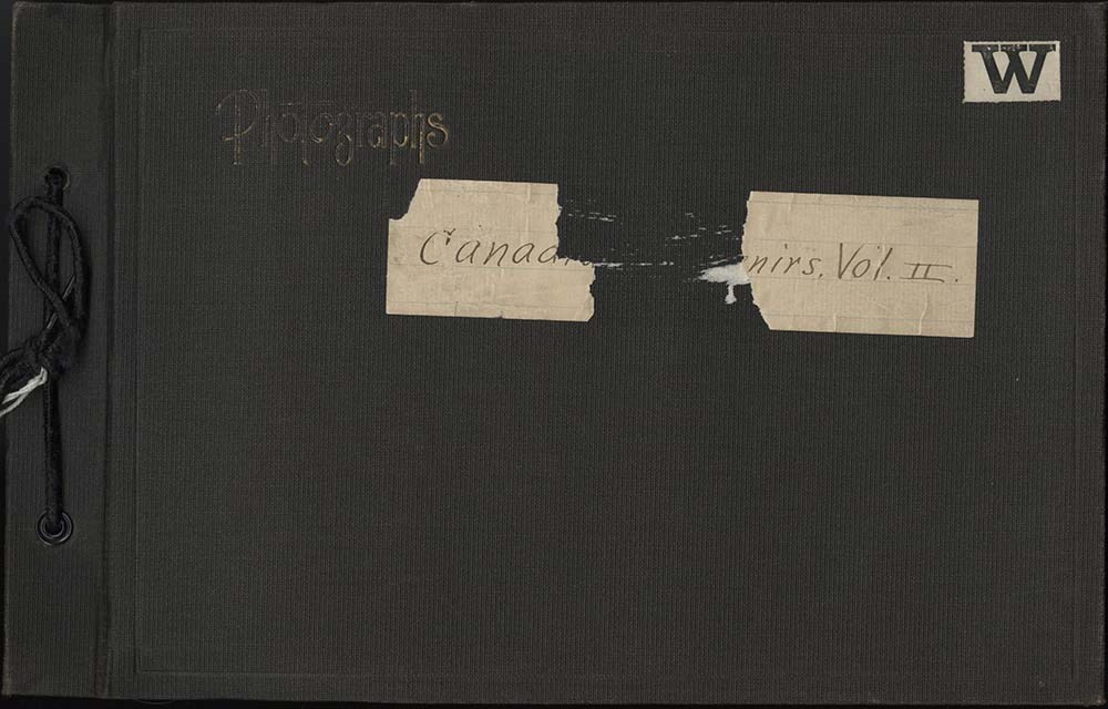
Canadian Souvenirs Vol. II Album
https://archives.whyte.org/en/permalink/descriptions57682
- Part Of
- Alpine Club of Canada fonds
- Scope & Content
- Item consists of 1 photograph album compiled by Frank W. Freeborn of New York City for the Alpine Club of Canada. The album pertains to a 1917 ACC trip throughout the Rocky Mountains in British Columbia, including the Field, Lake O'Hara, Assiniboine, and Glacier areas, and includes black and white …
- Date Range
- 1917
- Reference Code
- V14 / AC 55P / PD - 10
- Description Level
- 6 / Item
- GMD
- Album
- Photograph
1 image
1 Electronic Resource
- Part Of
- Alpine Club of Canada fonds
- Description Level
- 6 / Item
- Fonds Number
- M200 / S6 / V14
- Series
- IV.B. Other material: photographic
- Sous-Fonds
- V14
- Accession Number
- 5200
- Reference Code
- V14 / AC 55P / PD - 10
- GMD
- Album
- Photograph
- Date Range
- 1917
- Physical Description
- 1 album (396 photographs : b&w and col. ; 28.6 x 18.5 cm)
- Scope & Content
- Item consists of 1 photograph album compiled by Frank W. Freeborn of New York City for the Alpine Club of Canada. The album pertains to a 1917 ACC trip throughout the Rocky Mountains in British Columbia, including the Field, Lake O'Hara, Assiniboine, and Glacier areas, and includes black and white photographs, all of which are numbered. A bound-edge flip-book style album, it is tied together with a black string and has a faded gilt "Photographs" embossed in the top left corner of the front cover. Additionally, a small white paper with "W" is adhered to the top right corner and a piece of a lined paper is adhered to the centre with the album's title - this piece is torn through the middle but, as per the title page, the album is titled "Canadian Souvenirs Vol. II."
- Name Access
- Alpine Club of Canada
- Subject Access
- Activities
- Alpine Club of Canada
- Animals
- Backpacking
- Bow Falls
- Bow River
- Bow Valley
- Buildings
- Camps
- Canadian Pacific Railway
- Climbing
- Clothing and dress
- Club
- Environment and Nature
- Glaciers
- Hiking
- Hotels
- Lake O'hara
- Landscapes
- Mountaineering
- Mountaineers
- Mountains
- Period costume
- Photography
- Portrait
- Railways
- Scenery
- scenic
- Trails
- Trains
- Transportation
- Women
- Geographic Access
- Field
- Yoho National Park
- Glacier National Park
- Assiniboine
- Assiniboine Provincial Park
- British Columbia
- Language
- English
- Finding Aid
- Inventory of the Alpine Club of Canada Collection, 1986, provides group or item-level description to this material
- Title Source
- Title based on item
- Processing Status
- Processed
Electronic Resources
Images
This material is presented as originally created; it may contain outdated cultural descriptions and
potentially offensive content.
Read more.