Narrow Results By
Map showing progress of World War II
https://archives.whyte.org/en/permalink/catalogue21533
- Medium
- Library - Maps and blueprints (unannotated; published)
- Map
- Published Date
- October 7, 1939
- Call Number
- C13-12.4
- Published Date
- October 7, 1939
- Subjects
- Europe
- Notes
- Map from the Star Weekly, October 7, 1939
- Accession Number
- 400
- Call Number
- C13-12.4
- Collection
- Archives Library
This material is presented as originally created; it may contain outdated cultural descriptions and
potentially offensive content.
Read more.
[Jasper Park : north sheet]
https://archives.whyte.org/en/permalink/catalogue23176
- Medium
- Library - Maps and blueprints (unannotated; published)
- Map
- Published Date
- 1939
- Publisher
- Department of Mines and Resources
- Edition
- Preliminary edition
- Call Number
- C2-2.5
- Edition
- Preliminary edition
- Publisher
- Department of Mines and Resources
- Published Date
- 1939
- Physical Description
- 1 map : col
- Scale
- Scale: 3 miles to 1 inch
- Relief: Contour interval 200 ft.
- Subjects
- Jasper National Park
- Accession Number
- 626
- 3349
- Call Number
- C2-2.5
- Collection
- Archives Library
This material is presented as originally created; it may contain outdated cultural descriptions and
potentially offensive content.
Read more.
[Jasper Park : south sheet]
https://archives.whyte.org/en/permalink/catalogue23179
- Medium
- Library - Maps and blueprints (unannotated; published)
- Map
- Published Date
- 1939
- Publisher
- Department of Mines and Resources
- Edition
- Preliminary edition
- Call Number
- C2-2.6
- Edition
- Preliminary edition
- Publisher
- Department of Mines and Resources
- Published Date
- 1939
- Physical Description
- 1 map : col
- Scale
- 3 miles to 1 inch
- Relief: Contour interval 200'
- Subjects
- Jasper National Park
- Accession Number
- 626
- Call Number
- C2-2.6
- Collection
- Archives Library
This material is presented as originally created; it may contain outdated cultural descriptions and
potentially offensive content.
Read more.
- Medium
- Library - Maps and blueprints (unannotated; published)
- Map
- Published Date
- 1939
- Publisher
- Dept. of Mines and Resources
- Call Number
- C2-4.5
- Publisher
- Dept. of Mines and Resources
- Published Date
- 1939
- Physical Description
- 1 map : col
- Scale
- Scale: 2 miles to 1 inch
- Relief: Contour interal 250'
- Subjects
- Yoho National Park
- Accession Number
- 718 deaccessioned
- 626
- 3349 deaccessioned
- 1888 deaccessioned
- Call Number
- C2-4.5
- Collection
- Archives Library
This material is presented as originally created; it may contain outdated cultural descriptions and
potentially offensive content.
Read more.
[Bragg Creek 82J/15 East, Alberta]
https://archives.whyte.org/en/permalink/catalogue23517
- Medium
- Library - Maps and blueprints (unannotated; published)
- Map
- Published Date
- 1939
- Publisher
- Dept. of Mines and Technical Surveys
- Call Number
- NTS
- 82J/15E
- Publisher
- Dept. of Mines and Technical Surveys
- Published Date
- 1939
- Physical Description
- 1 map : black and white
- Scale
- Scale: 1:50,000
- Relief: Contour interval 100'
- Subjects
- Bragg Creek
- Alberta
- Notes
- National Topographic System
- Call Number
- NTS
- 82J/15E
- Collection
- Archives Library
This material is presented as originally created; it may contain outdated cultural descriptions and
potentially offensive content.
Read more.
[Morley 82 0/2 West - Alberta]
https://archives.whyte.org/en/permalink/catalogue23745
- Medium
- Library - Maps and blueprints (unannotated; published)
- Map
- Published Date
- 1939
- Publisher
- Dept. of Mines and Technical Surveys
- Call Number
- NTS
- 820/2W
- Publisher
- Dept. of Mines and Technical Surveys
- Published Date
- 1939
- Physical Description
- Black and White
- Scale
- Scale: 1:50,000
- Relief: Contour interval 100'
- Subjects
- Morley 82 0/2 West - Alberta
- Notes
- National Topographic System
- Call Number
- NTS
- 820/2W
- Collection
- Archives Library
This material is presented as originally created; it may contain outdated cultural descriptions and
potentially offensive content.
Read more.
Completion of Jasper Highway
https://archives.whyte.org/en/permalink/catalogue24288
- Medium
- Library - Maps and blueprints (unannotated; published)
- Map
- Published Date
- 1939
- Publisher
- Department of Mines and Resources
- Call Number
- C2-1.2
- Publisher
- Department of Mines and Resources
- Published Date
- 1939
- Physical Description
- 1 map : col
- Scale
- Scale: 3 miles : 1 inch
- Relief: Contour interval 250'
- Subjects
- Banff National Park
- Accession Number
- 400
- 626 Deaccessioned (2)
- 3349 Deaccessioned
- Call Number
- C2-1.2
- Collection
- Archives Library
This material is presented as originally created; it may contain outdated cultural descriptions and
potentially offensive content.
Read more.
Automobile Road Map of Alberta
https://archives.whyte.org/en/permalink/catalogue24397
- Medium
- Library - Maps and blueprints (unannotated; published)
- Map
- Published Date
- 1939
- Publisher
- Alberta Motor Association
- Call Number
- C9-1.8
- Publisher
- Alberta Motor Association
- Published Date
- 1939
- Scale
- Scale: 17 1/2 miles to the inch
- Subjects
- Alberta-Highways
- Accession Number
- 2511
- 2933
- Call Number
- C9-1.8
- Collection
- Archives Library
This material is presented as originally created; it may contain outdated cultural descriptions and
potentially offensive content.
Read more.
Automobile Road Map of Alberta
https://archives.whyte.org/en/permalink/catalogue24398
- Medium
- Library - Maps and blueprints (unannotated; published)
- Map
- Published Date
- 1939
- Publisher
- Alberta Motor Association
- Call Number
- C9-1.8
- Publisher
- Alberta Motor Association
- Published Date
- 1939
- Scale
- Scale: 17 1/2 miles to the inch
- Subjects
- Alberta-Highways
- Accession Number
- 2511
- 2933
- Call Number
- C9-1.8
- Collection
- Archives Library
This material is presented as originally created; it may contain outdated cultural descriptions and
potentially offensive content.
Read more.
[Atlantic Ocean]
https://archives.whyte.org/en/permalink/catalogue24848
- Medium
- Library - Maps and blueprints (unannotated; published)
- Map
- Published Date
- 1939
- Publisher
- National Geographic Society
- Call Number
- C13-9.1
- Publisher
- National Geographic Society
- Published Date
- 1939
- Scale
- 316 miles to 1 inch
- Subjects
- Atlantic Ocean
- Accession Number
- 400
- Call Number
- C13-9.1
- Collection
- Archives Library
This material is presented as originally created; it may contain outdated cultural descriptions and
potentially offensive content.
Read more.
[Kootenay Park]
https://archives.whyte.org/en/permalink/catalogue23207
- Medium
- Library - Maps and blueprints (unannotated; published)
- Map
- Published Date
- 1938
- Publisher
- Dept. of Mines and Resources
- Call Number
- C2-5.3
- Publisher
- Dept. of Mines and Resources
- Published Date
- 1938
- Physical Description
- 1 map : col
- Scale
- Scale: 2 miles to 1 inch
- Relief: Contour Interval 100'
- Subjects
- Kootenay National Park
- Accession Number
- 400
- 3079 deaccessioned
- Call Number
- C2-5.3
- Collection
- Archives Library
This material is presented as originally created; it may contain outdated cultural descriptions and
potentially offensive content.
Read more.
Topographical map
https://archives.whyte.org/en/permalink/catalogue24613
- Medium
- Library - Maps and blueprints (unannotated; published)
- Map
- Published Date
- 1938
- Publisher
- Dept. of Mines and Resources
- Call Number
- C3-1.4
- Publisher
- Dept. of Mines and Resources
- Published Date
- 1938
- Physical Description
- Colour
- Scale
- Scale: 1:63,360
- Relief: Contour interval 100 ft.
- Subjects
- Banff and Vicinity
- Accession Number
- 400
- 718 (Dup. in map room)
- 1003 (1" " " ")
- 1113 (1" " " ")
- 2684 (1" " " ")
- Call Number
- C3-1.4
- Collection
- Archives Library
This material is presented as originally created; it may contain outdated cultural descriptions and
potentially offensive content.
Read more.
Map of Banff, Yoho and Kootenay Parks especially designed for the Trail Riders and the Skyline Hikers
https://archives.whyte.org/en/permalink/catalogue21346
- Medium
- Library - Maps and blueprints (unannotated; published)
- Map
- Published Date
- 1938 (approx.)
- Publisher
- Rand McNally & Co.
- Call Number
- C6-4.1(b)
- Publisher
- Rand McNally & Co.
- Published Date
- 1938 (approx.)
- Subjects
- Trail Riders Map
- Accession Number
- 540
- 5390
- Call Number
- C6-4.1(b)
- Collection
- Archives Library
This material is presented as originally created; it may contain outdated cultural descriptions and
potentially offensive content.
Read more.
Map of Banff, Yoho and Kootenay Parks especially designed for the Trail Riders and the Skyline Hikers
https://archives.whyte.org/en/permalink/catalogue21376
- Medium
- Library - Maps and blueprints (unannotated; published)
- Map
- Published Date
- 1938 (approx.)
- Publisher
- Rand McNally & Co.
- Call Number
- C6-4.1(b)
- Publisher
- Rand McNally & Co.
- Published Date
- 1938 (approx.)
- Subjects
- Trail Riders Map
- Accession Number
- 540
- 5390
- Call Number
- C6-4.1(b)
- Collection
- Archives Library
This material is presented as originally created; it may contain outdated cultural descriptions and
potentially offensive content.
Read more.
- Date
- 1938
- Material
- wood; metal
- Catalogue Number
- 102.04.1089
- Description
- Homemade looking wooden box with a raised back panel and metal bison with the caption “CANADA’S NATIONAL PARKS 1938” carved into the metal under the bison. Two large, decorative (?) nails on front of box in addition to four smaller and more practical ones. Wooden knobs on bottom of box so that it i…
1 image
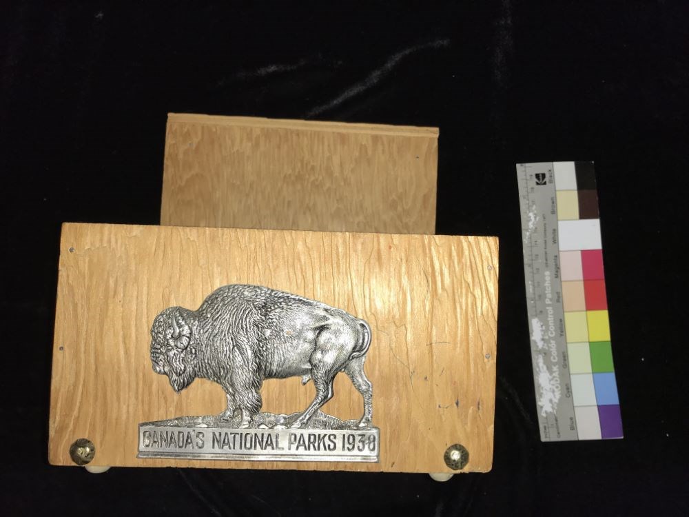
- Title
- Trinket Box
- Date
- 1938
- Material
- wood; metal
- Dimensions
- 20.3 x 19.5 x 16.5 cm
- Description
- Homemade looking wooden box with a raised back panel and metal bison with the caption “CANADA’S NATIONAL PARKS 1938” carved into the metal under the bison. Two large, decorative (?) nails on front of box in addition to four smaller and more practical ones. Wooden knobs on bottom of box so that it is elevated.
- Credit
- Gift of Nicholas Morant, Banff, 2006
- Catalogue Number
- 102.04.1089
Images
This material is presented as originally created; it may contain outdated cultural descriptions and
potentially offensive content.
Read more.
[Bearberry 820/15 West, Alberta]
https://archives.whyte.org/en/permalink/catalogue23487
- Medium
- Library - Maps and blueprints (unannotated; published)
- Map
- Published Date
- 1937
- Publisher
- Dept. of Mines and Technical Surveys
- Call Number
- NTS
- 820/15W
- Publisher
- Dept. of Mines and Technical Surveys
- Published Date
- 1937
- Physical Description
- 1 map : black and white
- Scale
- Scale: 1:50,000
- Relief: Contour interval 100'
- Notes
- National Topographic System
- Call Number
- NTS
- 820/15W
- Collection
- Archives Library
This material is presented as originally created; it may contain outdated cultural descriptions and
potentially offensive content.
Read more.
[Fallentimber 820/10 East, Alberta]
https://archives.whyte.org/en/permalink/catalogue23610
- Medium
- Library - Maps and blueprints (unannotated; published)
- Map
- Published Date
- 1937
- Publisher
- Dept. of Mines and Technical Surveys
- Call Number
- NTS
- 820/10E
- Publisher
- Dept. of Mines and Technical Surveys
- Published Date
- 1937
- Physical Description
- 1 map : black and white
- Scale
- Scale: 1:50,000
- Relief: Contour interval 100'
- Subjects
- Fallentimber
- Alberta
- Notes
- National Topographic System
- Call Number
- NTS
- 820/10E
- Collection
- Archives Library
This material is presented as originally created; it may contain outdated cultural descriptions and
potentially offensive content.
Read more.
[Fallentimber 820/10 West, Alberta]
https://archives.whyte.org/en/permalink/catalogue23611
- Medium
- Library - Maps and blueprints (unannotated; published)
- Map
- Published Date
- 1937
- Publisher
- Dept. of Mines and Technical Surveys
- Call Number
- NTS
- 820/10W
- Publisher
- Dept. of Mines and Technical Surveys
- Published Date
- 1937
- Physical Description
- 1 map : black and white
- Scale
- Scale: 1:50,000
- Relief: Contour interval 100'
- Subjects
- Fallentimber
- Alberta
- Notes
- National Topographic System
- Call Number
- NTS
- 820/10W
- Collection
- Archives Library
This material is presented as originally created; it may contain outdated cultural descriptions and
potentially offensive content.
Read more.
Map of the Province of Alberta
https://archives.whyte.org/en/permalink/catalogue24399
- Medium
- Library - Maps and blueprints (unannotated; published)
- Map
- Published Date
- 1937
- Publisher
- Department of Lands and Mines
- Call Number
- C9-1.9
- Publisher
- Department of Lands and Mines
- Published Date
- 1937
- Scale
- Scale: 17 1/2 miles to the inch
- Subjects
- Alberta
- Notes
- Major highways in red
- Accession Number
- 2511
- Call Number
- C9-1.9
- Collection
- Archives Library
This material is presented as originally created; it may contain outdated cultural descriptions and
potentially offensive content.
Read more.
- Medium
- Library - Maps and blueprints (unannotated; published)
- Map
- Published Date
- 1937
- Publisher
- Manufacturers Life Insurance Co.
- Call Number
- C13-11.2
- Publisher
- Manufacturers Life Insurance Co.
- Published Date
- 1937
- Subjects
- World
- Notes
- Air mail services, Trade routes and principal short-wave radio stations of the World
- Accession Number
- 400
- Call Number
- C13-11.2
- Collection
- Archives Library
This material is presented as originally created; it may contain outdated cultural descriptions and
potentially offensive content.
Read more.