Narrow Results By
- Peter Whyte (1905 – 1966, Canadian) 248
- Catharine Robb Whyte, O. C. (1906 – 1979, Canadian) 150
- Carl Clemens Moritz Rungius (1869 – 1959, American) 10
- Aleen Aked (1907 – 2003, Canadian) 4
- Sydney C. Vick (1855 – 1922, Canadian) 4
- Cornelius David Krieghoff (1815 – 1872, Canadian) 2
- Edmee Moore (1908 – 1971, Canadian) 2
- Morant, Nicholas 2
- Schaffer, Mary 2
- Adams, Molly 1
- Alberta/British Columbia Boundary Survey 1
- Aldro T. Hibbard (1886 – 1972, American) 1
Map showing progress of World War II
https://archives.whyte.org/en/permalink/catalogue21533
- Medium
- Library - Maps and blueprints (unannotated; published)
- Map
- Published Date
- October 7, 1939
- Call Number
- C13-12.4
- Published Date
- October 7, 1939
- Subjects
- Europe
- Notes
- Map from the Star Weekly, October 7, 1939
- Accession Number
- 400
- Call Number
- C13-12.4
- Collection
- Archives Library
This material is presented as originally created; it may contain outdated cultural descriptions and
potentially offensive content.
Read more.
[Morley 82 0/2 West - Alberta]
https://archives.whyte.org/en/permalink/catalogue23745
- Medium
- Library - Maps and blueprints (unannotated; published)
- Map
- Published Date
- 1939
- Publisher
- Dept. of Mines and Technical Surveys
- Call Number
- NTS
- 820/2W
- Publisher
- Dept. of Mines and Technical Surveys
- Published Date
- 1939
- Physical Description
- Black and White
- Scale
- Scale: 1:50,000
- Relief: Contour interval 100'
- Subjects
- Morley 82 0/2 West - Alberta
- Notes
- National Topographic System
- Call Number
- NTS
- 820/2W
- Collection
- Archives Library
This material is presented as originally created; it may contain outdated cultural descriptions and
potentially offensive content.
Read more.
Completion of Jasper Highway
https://archives.whyte.org/en/permalink/catalogue24288
- Medium
- Library - Maps and blueprints (unannotated; published)
- Map
- Published Date
- 1939
- Publisher
- Department of Mines and Resources
- Call Number
- C2-1.2
- Publisher
- Department of Mines and Resources
- Published Date
- 1939
- Physical Description
- 1 map : col
- Scale
- Scale: 3 miles : 1 inch
- Relief: Contour interval 250'
- Subjects
- Banff National Park
- Accession Number
- 400
- 626 Deaccessioned (2)
- 3349 Deaccessioned
- Call Number
- C2-1.2
- Collection
- Archives Library
This material is presented as originally created; it may contain outdated cultural descriptions and
potentially offensive content.
Read more.
Automobile Road Map of Alberta
https://archives.whyte.org/en/permalink/catalogue24397
- Medium
- Library - Maps and blueprints (unannotated; published)
- Map
- Published Date
- 1939
- Publisher
- Alberta Motor Association
- Call Number
- C9-1.8
- Publisher
- Alberta Motor Association
- Published Date
- 1939
- Scale
- Scale: 17 1/2 miles to the inch
- Subjects
- Alberta-Highways
- Accession Number
- 2511
- 2933
- Call Number
- C9-1.8
- Collection
- Archives Library
This material is presented as originally created; it may contain outdated cultural descriptions and
potentially offensive content.
Read more.
Automobile Road Map of Alberta
https://archives.whyte.org/en/permalink/catalogue24398
- Medium
- Library - Maps and blueprints (unannotated; published)
- Map
- Published Date
- 1939
- Publisher
- Alberta Motor Association
- Call Number
- C9-1.8
- Publisher
- Alberta Motor Association
- Published Date
- 1939
- Scale
- Scale: 17 1/2 miles to the inch
- Subjects
- Alberta-Highways
- Accession Number
- 2511
- 2933
- Call Number
- C9-1.8
- Collection
- Archives Library
This material is presented as originally created; it may contain outdated cultural descriptions and
potentially offensive content.
Read more.
[Atlantic Ocean]
https://archives.whyte.org/en/permalink/catalogue24848
- Medium
- Library - Maps and blueprints (unannotated; published)
- Map
- Published Date
- 1939
- Publisher
- National Geographic Society
- Call Number
- C13-9.1
- Publisher
- National Geographic Society
- Published Date
- 1939
- Scale
- 316 miles to 1 inch
- Subjects
- Atlantic Ocean
- Accession Number
- 400
- Call Number
- C13-9.1
- Collection
- Archives Library
This material is presented as originally created; it may contain outdated cultural descriptions and
potentially offensive content.
Read more.
[Jasper Park : north sheet]
https://archives.whyte.org/en/permalink/catalogue23176
- Medium
- Library - Maps and blueprints (unannotated; published)
- Map
- Published Date
- 1939
- Publisher
- Department of Mines and Resources
- Edition
- Preliminary edition
- Call Number
- C2-2.5
- Edition
- Preliminary edition
- Publisher
- Department of Mines and Resources
- Published Date
- 1939
- Physical Description
- 1 map : col
- Scale
- Scale: 3 miles to 1 inch
- Relief: Contour interval 200 ft.
- Subjects
- Jasper National Park
- Accession Number
- 626
- 3349
- Call Number
- C2-2.5
- Collection
- Archives Library
This material is presented as originally created; it may contain outdated cultural descriptions and
potentially offensive content.
Read more.
[Jasper Park : south sheet]
https://archives.whyte.org/en/permalink/catalogue23179
- Medium
- Library - Maps and blueprints (unannotated; published)
- Map
- Published Date
- 1939
- Publisher
- Department of Mines and Resources
- Edition
- Preliminary edition
- Call Number
- C2-2.6
- Edition
- Preliminary edition
- Publisher
- Department of Mines and Resources
- Published Date
- 1939
- Physical Description
- 1 map : col
- Scale
- 3 miles to 1 inch
- Relief: Contour interval 200'
- Subjects
- Jasper National Park
- Accession Number
- 626
- Call Number
- C2-2.6
- Collection
- Archives Library
This material is presented as originally created; it may contain outdated cultural descriptions and
potentially offensive content.
Read more.
- Medium
- Library - Maps and blueprints (unannotated; published)
- Map
- Published Date
- 1939
- Publisher
- Dept. of Mines and Resources
- Call Number
- C2-4.5
- Publisher
- Dept. of Mines and Resources
- Published Date
- 1939
- Physical Description
- 1 map : col
- Scale
- Scale: 2 miles to 1 inch
- Relief: Contour interal 250'
- Subjects
- Yoho National Park
- Accession Number
- 718 deaccessioned
- 626
- 3349 deaccessioned
- 1888 deaccessioned
- Call Number
- C2-4.5
- Collection
- Archives Library
This material is presented as originally created; it may contain outdated cultural descriptions and
potentially offensive content.
Read more.
[Bragg Creek 82J/15 East, Alberta]
https://archives.whyte.org/en/permalink/catalogue23517
- Medium
- Library - Maps and blueprints (unannotated; published)
- Map
- Published Date
- 1939
- Publisher
- Dept. of Mines and Technical Surveys
- Call Number
- NTS
- 82J/15E
- Publisher
- Dept. of Mines and Technical Surveys
- Published Date
- 1939
- Physical Description
- 1 map : black and white
- Scale
- Scale: 1:50,000
- Relief: Contour interval 100'
- Subjects
- Bragg Creek
- Alberta
- Notes
- National Topographic System
- Call Number
- NTS
- 82J/15E
- Collection
- Archives Library
This material is presented as originally created; it may contain outdated cultural descriptions and
potentially offensive content.
Read more.
- Date
- 1939
- Medium
- oil on canvas
- Catalogue Number
- RuC.02.03
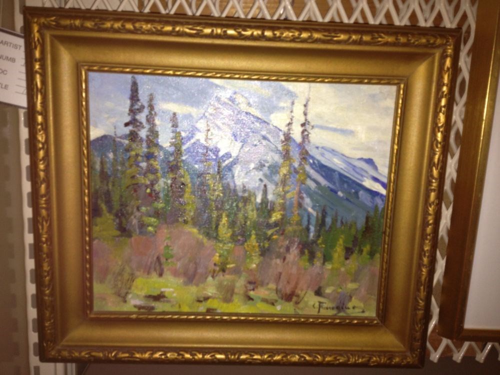
- Description
- A realistic rendering of Mount Rundle; foreground green and brownish grasses;evergreen trees through centre with a snow capped Mount Rundle in background; blue sky with white clouds top right. Credit both The Banff Centre and Mrs. J. I. Brewster in any exhibition or publication of the collection, e…
1 image
- Title
- Mount Rundle
- Date
- 1939
- Medium
- oil on canvas
- Dimensions
- 22.6 x 28.0 cm
- Description
- A realistic rendering of Mount Rundle; foreground green and brownish grasses;evergreen trees through centre with a snow capped Mount Rundle in background; blue sky with white clouds top right. Credit both The Banff Centre and Mrs. J. I. Brewster in any exhibition or publication of the collection, either in whole or in part. Banff Centre catalogue numbers: 81 0317 A; 20670
- Subject
- landscape
- Canadian Rockies
- mountain
- Credit
- Gift of Banff Centre Brewster Donation, Banff, 1986
- Catalogue Number
- RuC.02.03
Images
This material is presented as originally created; it may contain outdated cultural descriptions and
potentially offensive content.
Read more.
Topographical map
https://archives.whyte.org/en/permalink/catalogue24613
- Medium
- Library - Maps and blueprints (unannotated; published)
- Map
- Published Date
- 1938
- Publisher
- Dept. of Mines and Resources
- Call Number
- C3-1.4
- Publisher
- Dept. of Mines and Resources
- Published Date
- 1938
- Physical Description
- Colour
- Scale
- Scale: 1:63,360
- Relief: Contour interval 100 ft.
- Subjects
- Banff and Vicinity
- Accession Number
- 400
- 718 (Dup. in map room)
- 1003 (1" " " ")
- 1113 (1" " " ")
- 2684 (1" " " ")
- Call Number
- C3-1.4
- Collection
- Archives Library
This material is presented as originally created; it may contain outdated cultural descriptions and
potentially offensive content.
Read more.
Map of Banff, Yoho and Kootenay Parks especially designed for the Trail Riders and the Skyline Hikers
https://archives.whyte.org/en/permalink/catalogue21346
- Medium
- Library - Maps and blueprints (unannotated; published)
- Map
- Published Date
- 1938 (approx.)
- Publisher
- Rand McNally & Co.
- Call Number
- C6-4.1(b)
- Publisher
- Rand McNally & Co.
- Published Date
- 1938 (approx.)
- Subjects
- Trail Riders Map
- Accession Number
- 540
- 5390
- Call Number
- C6-4.1(b)
- Collection
- Archives Library
This material is presented as originally created; it may contain outdated cultural descriptions and
potentially offensive content.
Read more.
Map of Banff, Yoho and Kootenay Parks especially designed for the Trail Riders and the Skyline Hikers
https://archives.whyte.org/en/permalink/catalogue21376
- Medium
- Library - Maps and blueprints (unannotated; published)
- Map
- Published Date
- 1938 (approx.)
- Publisher
- Rand McNally & Co.
- Call Number
- C6-4.1(b)
- Publisher
- Rand McNally & Co.
- Published Date
- 1938 (approx.)
- Subjects
- Trail Riders Map
- Accession Number
- 540
- 5390
- Call Number
- C6-4.1(b)
- Collection
- Archives Library
This material is presented as originally created; it may contain outdated cultural descriptions and
potentially offensive content.
Read more.
[Kootenay Park]
https://archives.whyte.org/en/permalink/catalogue23207
- Medium
- Library - Maps and blueprints (unannotated; published)
- Map
- Published Date
- 1938
- Publisher
- Dept. of Mines and Resources
- Call Number
- C2-5.3
- Publisher
- Dept. of Mines and Resources
- Published Date
- 1938
- Physical Description
- 1 map : col
- Scale
- Scale: 2 miles to 1 inch
- Relief: Contour Interval 100'
- Subjects
- Kootenay National Park
- Accession Number
- 400
- 3079 deaccessioned
- Call Number
- C2-5.3
- Collection
- Archives Library
This material is presented as originally created; it may contain outdated cultural descriptions and
potentially offensive content.
Read more.
Melting Snow, near Andalsnes, Norway
https://archives.whyte.org/en/permalink/artifactwyp.01.017
- Date
- 1938
- Medium
- oil on canvas
- Catalogue Number
- WyP.01.017
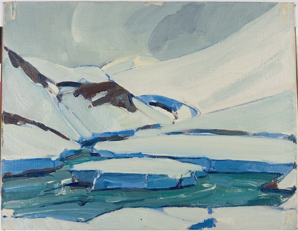
- Description
- Colour: greys, blue. Two large round chunks of ice sit in a pool of water surrounded at the bottom and top by snow banks. Three dark rock patches show through the snow on the left side. A long snow slope crosses the picture in the upper half. Grey sky fills the upper left corner over to right of ce…
1 image
- Title
- Melting Snow, near Andalsnes, Norway
- Date
- 1938
- Medium
- oil on canvas
- Dimensions
- 35 x 27.5 cm
- Description
- Colour: greys, blue. Two large round chunks of ice sit in a pool of water surrounded at the bottom and top by snow banks. Three dark rock patches show through the snow on the left side. A long snow slope crosses the picture in the upper half. Grey sky fills the upper left corner over to right of center.
- Credit
- Gift of Catharine Robb Whyte, O. C., Banff, 1968
- Catalogue Number
- WyP.01.017
Images
This material is presented as originally created; it may contain outdated cultural descriptions and
potentially offensive content.
Read more.
Romsdal Valley, Norway
https://archives.whyte.org/en/permalink/artifactwyp.01.018
- Date
- 1938
- Medium
- oil on canvas
- Catalogue Number
- WyP.01.018
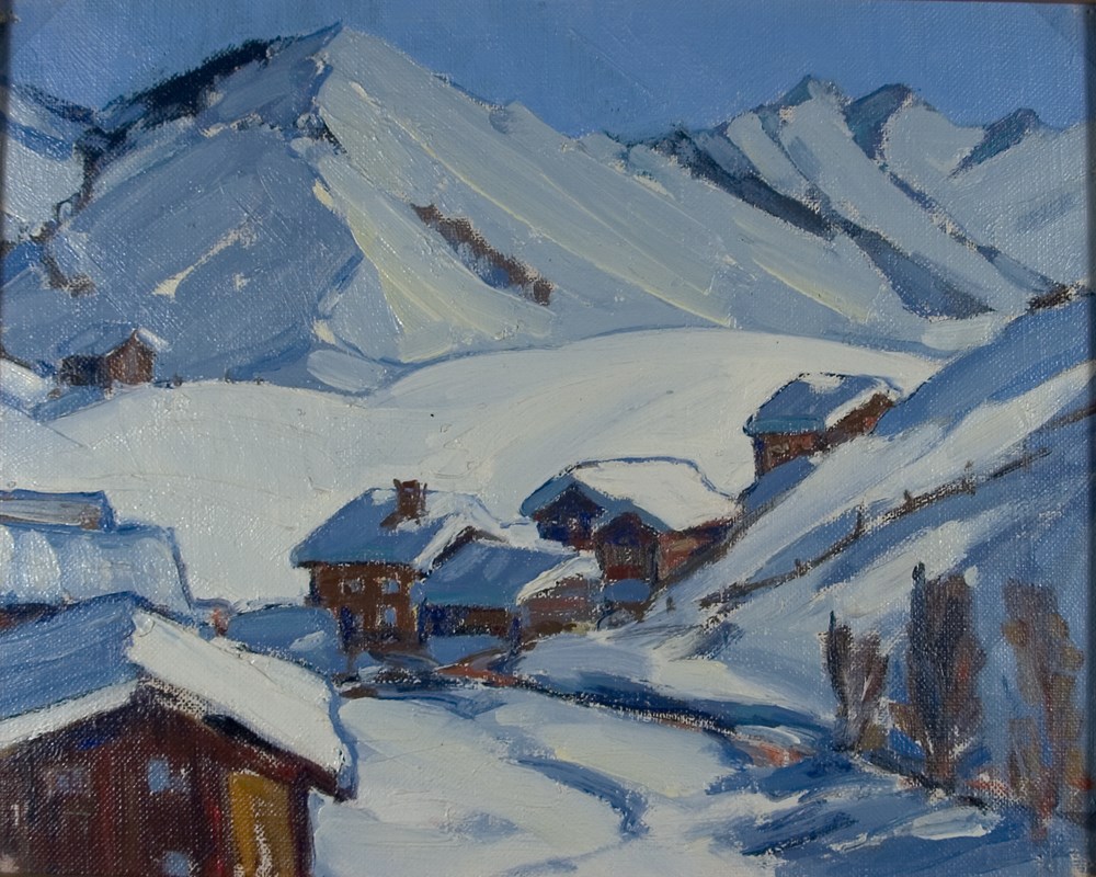
- Description
- Colour: green, blue, purple. Four little buildings sit in green hills above a patch of white snow at the left side. Two more sit right of center. In the lower right corner is a dark shape. In the distance on he right side rises a mountain with snow sides. A ribbon of cloud crosses the blue sky behi…
1 image
- Title
- Romsdal Valley, Norway
- Date
- 1938
- Medium
- oil on canvas
- Dimensions
- 35 x 27.5 cm
- Description
- Colour: green, blue, purple. Four little buildings sit in green hills above a patch of white snow at the left side. Two more sit right of center. In the lower right corner is a dark shape. In the distance on he right side rises a mountain with snow sides. A ribbon of cloud crosses the blue sky behind.
- Subject
- landscape
- mountain
- winter
- architecture
- rural
- Credit
- Gift of Catharine Robb Whyte, O. C., Banff, 1970
- Catalogue Number
- WyP.01.018
Images

This material is presented as originally created; it may contain outdated cultural descriptions and
potentially offensive content.
Read more.
Klosters, Switzerland
https://archives.whyte.org/en/permalink/artifactwyp.01.001
- Date
- 1938
- Medium
- oil on canvas
- Catalogue Number
- WyP.01.001
- Description
- Colour: blue. A building in the lower left corner. Two roofs can be seen behind and five more buildings across the picture towards the night. There are three tall shrubs in the lower night corner. There is a bank of snow behind the buildings and mountain peaks beyond. Bit of clear blue sky at the u…
1 image
- Title
- Klosters, Switzerland
- Date
- 1938
- Medium
- oil on canvas
- Dimensions
- 27.8 x 34.9 cm
- Description
- Colour: blue. A building in the lower left corner. Two roofs can be seen behind and five more buildings across the picture towards the night. There are three tall shrubs in the lower night corner. There is a bank of snow behind the buildings and mountain peaks beyond. Bit of clear blue sky at the upper edge.
- Subject
- landscape
- mountain
- winter
- architecture
- rural
- Credit
- Gift of Catharine Robb Whyte, O. C., Banff, 1968
- Catalogue Number
- WyP.01.001
Images
This material is presented as originally created; it may contain outdated cultural descriptions and
potentially offensive content.
Read more.
Grindelwald, Switzerland
https://archives.whyte.org/en/permalink/artifactwyp.01.002
- Date
- 1938
- Medium
- oil on canvas
- Catalogue Number
- WyP.01.002
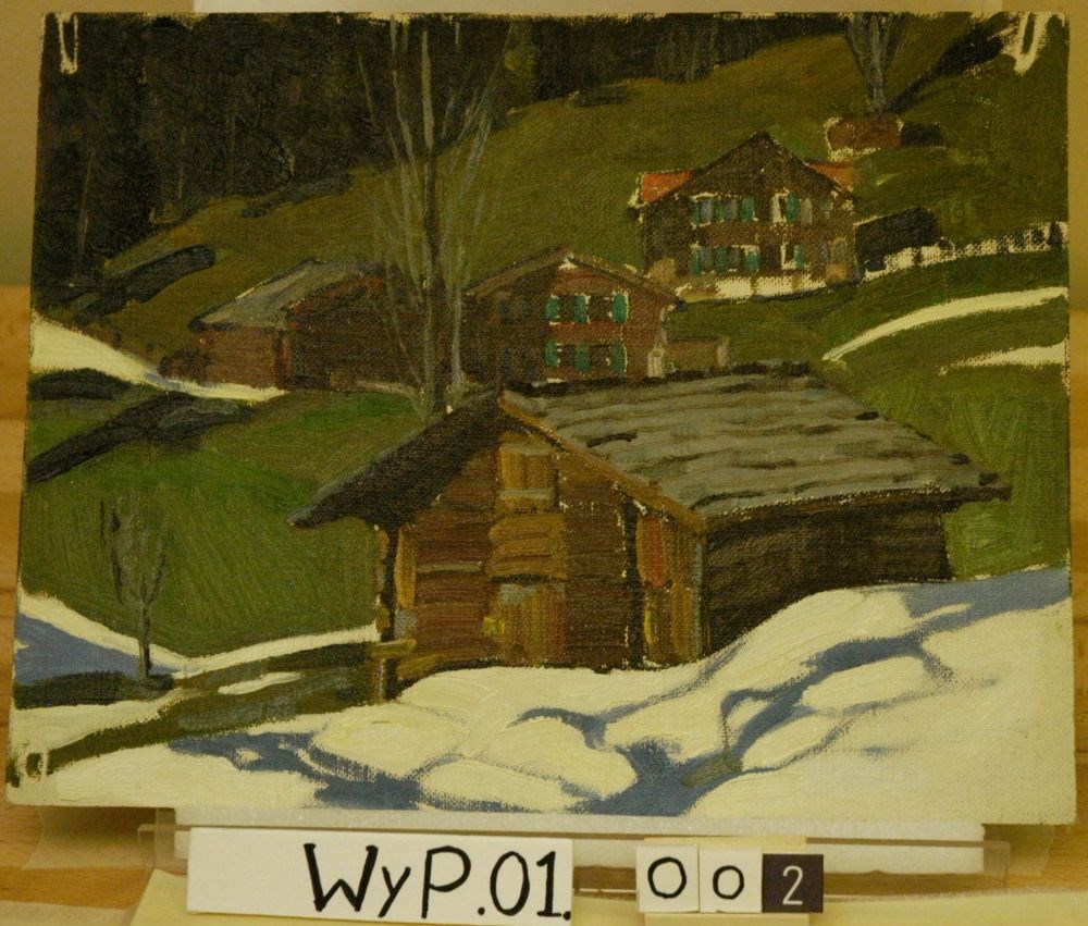
- Description
- Colour: green, brown, blue. Foreground is snow patches. Central image, night of canter is a log cabin. To the left is a scrawny tree and behind the cabin is a bare fill. In the background are three more cabins with green and blue shutters, situated on the green slope. Across the upper left corner i…
1 image
- Title
- Grindelwald, Switzerland
- Date
- 1938
- Medium
- oil on canvas
- Dimensions
- 27.5 x 35 cm
- Description
- Colour: green, brown, blue. Foreground is snow patches. Central image, night of canter is a log cabin. To the left is a scrawny tree and behind the cabin is a bare fill. In the background are three more cabins with green and blue shutters, situated on the green slope. Across the upper left corner is the forest.
- Subject
- landscape
- mountain
- winter
- architecture
- rural
- Credit
- Gift of Catharine Robb Whyte, O. C., Banff, 1968
- Catalogue Number
- WyP.01.002
Images
This material is presented as originally created; it may contain outdated cultural descriptions and
potentially offensive content.
Read more.
Klosters, Switzerland
https://archives.whyte.org/en/permalink/artifactwyp.01.003
- Date
- 1938
- Medium
- oil on canvas
- Catalogue Number
- WyP.01.003
- Description
- Colour: blue. A fence partly hidden by snow runs across the shadowed embankment half way up the picture. A row of brown buildings goes across the upper part. The forest and mountain peaks can be seen in the upper left corners.The sun comes from the right highlighting the areas not shadowed by the h…
1 image
- Title
- Klosters, Switzerland
- Date
- 1938
- Medium
- oil on canvas
- Dimensions
- 27.5 x 35 cm
- Description
- Colour: blue. A fence partly hidden by snow runs across the shadowed embankment half way up the picture. A row of brown buildings goes across the upper part. The forest and mountain peaks can be seen in the upper left corners.The sun comes from the right highlighting the areas not shadowed by the house.
- Subject
- landscape
- mountain
- winter
- architecture
- rural
- Credit
- Gift of Catharine Robb Whyte, O. C., Banff, 1968
- Catalogue Number
- WyP.01.003
Images
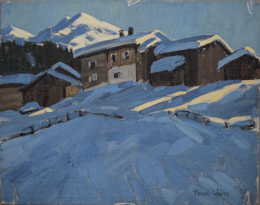
This material is presented as originally created; it may contain outdated cultural descriptions and
potentially offensive content.
Read more.