Narrow Results By
- Luxton family fonds 146
- Kidney family fonds 29
- Moore family fonds 26
- Joe Kootenay fonds 24
- Alpine Club of Canada fonds 17
- Peter and Catharine Whyte fonds 17
- Nicholas Morant fonds 16
- Eliza Hunter fonds 14
- Archives General File Collection 13
- Malcolm Geddes fonds 10
- Dorothy Wardle fonds 8
- Charles Reid fonds 5
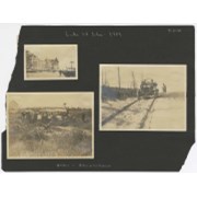
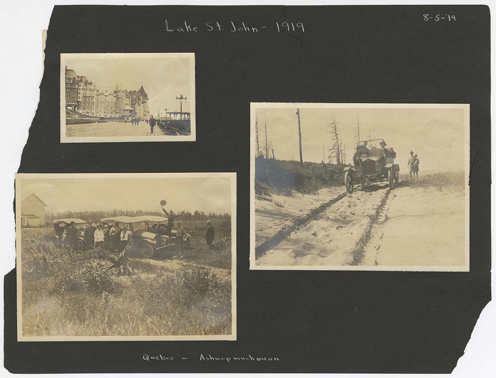
Lake St. John
https://archives.whyte.org/en/permalink/descriptions1825
- Part Of
- Lillian Gest fonds
- Scope & Content
- File pertains to loose pages from an album depicting a canoe trip in the Lac St. John region of Quebec in 1919. Includes scenes of motorcar transportation, camps, canoeing, scenic views, rivers, lakes, fishing, and unidentified people.
- Date Range
- 1919
- Reference Code
- V225 / II / C / ii / b / PD - 1
- Description Level
- 5 / File
- GMD
- Album
- Photograph print
1 image
1 Electronic Resource
- Part Of
- Lillian Gest fonds
- Description Level
- 5 / File
- Fonds Number
- M67 / S36 / V225
- Series
- II.C. Activities / photography
- Sous-Fonds
- V225
- Sub-Series
- ii.b. Photograph material / photograph album
- Accession Number
- 5142
- Reference Code
- V225 / II / C / ii / b / PD - 1
- Date Range
- 1919
- Physical Description
- 1 album (76 photographs : b&w ; 10.5 x 8 cm)
- History / Biographical
- See fonds level description
- Scope & Content
- File pertains to loose pages from an album depicting a canoe trip in the Lac St. John region of Quebec in 1919. Includes scenes of motorcar transportation, camps, canoeing, scenic views, rivers, lakes, fishing, and unidentified people.
- Notes
- Album pages were also accompanied by a Document consisting of the front half of a mailing envelope addressed to Lillian Gest - not scanned.
- Name Access
- Gest, Lillian
- Subject Access
- Activities
- Boats
- Camps
- Camping
- Canoes and canoeing
- Family and personal life
- Fishing
- Scenery
- Travel
- Geographic Access
- Quebec
- Canada
- Access Restrictions
- Microfilm copy available for reference use by appointment only.
- Language
- English
- Conservation
- Avoid further handling of file.
- Title Source
- Title based on contents of file
- Processing Status
- Processed
Electronic Resources
Images
This material is presented as originally created; it may contain outdated cultural descriptions and
potentially offensive content.
Read more.
Map showing the northern paortion of Vancouver Island
https://archives.whyte.org/en/permalink/catalogue24531
- Medium
- Library - Maps and blueprints (unannotated; published)
- Map
- Published Date
- 1919
- Publisher
- Dept. of Lands/Honourable T.D. Pattullo. J.E. Umbach Surveyor General
- Call Number
- C10-5.1
- Publisher
- Dept. of Lands/Honourable T.D. Pattullo. J.E. Umbach Surveyor General
- Published Date
- 1919
- Scale
- Scale: 4 miles - 1 inch
- Subjects
- British Columbia
- Vancouver Island
- Accession Number
- 400
- Call Number
- C10-5.1
- Collection
- Archives Library
This material is presented as originally created; it may contain outdated cultural descriptions and
potentially offensive content.
Read more.
Races of Europe
https://archives.whyte.org/en/permalink/catalogue21535
- Medium
- Library - Maps and blueprints (unannotated; published)
- Map
- Published Date
- 1919
- Publisher
- National Geographic Society
- Call Number
- C13-12.5(a)
- Publisher
- National Geographic Society
- Published Date
- 1919
- Subjects
- Europe
- Accession Number
- 400
- Call Number
- C13-12.5(a)
- Collection
- Archives Library
This material is presented as originally created; it may contain outdated cultural descriptions and
potentially offensive content.
Read more.
Royal visit address, Stoney Nakoda language translation
https://archives.whyte.org/en/permalink/descriptions55612
- Part Of
- Luxton family fonds
- Scope & Content
- FIle consists of a blueprint copy of an address presented to the Prince of Wales (later King Edward VIII) during his royal visit to Banff in 1919. The address is written in the Stoney Nakoda language, translated from English by George Kaquitts.
- Date Range
- 1919
- Reference Code
- LUX / III / C2 / 23
- Description Level
- 5 / File
- GMD
- Blueprint
- Textual record
- Part Of
- Luxton family fonds
- Description Level
- 5 / File
- Fonds Number
- LUX
- Series
- LUX / III / C : Extended family
- Sous-Fonds
- LUX / III : Luxton family sous-fonds
- Sub-Series
- LUX / III / C2 : McDougall and Ross families papers and photographs
- Accession Number
- LUX
- Reference Code
- LUX / III / C2 / 23
- Responsibility
- Translated by George Kaquitts
- Date Range
- 1919
- Physical Description
- 1 textual record : blueprint ; 35 x 45 cm
- Scope & Content
- FIle consists of a blueprint copy of an address presented to the Prince of Wales (later King Edward VIII) during his royal visit to Banff in 1919. The address is written in the Stoney Nakoda language, translated from English by George Kaquitts.
- Notes
- Item in file appears to be blueprint copy of original document
- Name Access
- Kaquitts, George
- Subject Access
- Public events
- Public Speaking
- Royal Visit
- Royalty
- First Nations
- Cultural pluralism
- Stoney Nakoda
- Geographic Access
- Canada
- Alberta
- Banff
- Language
- Stoney
- English
- Conservation
- Item stored in mylar
- Category
- First nations
- Cultural pluralism
- Title Source
- Title based on contents of file
- Processing Status
- Processed
This material is presented as originally created; it may contain outdated cultural descriptions and
potentially offensive content.
Read more.
Porteous family fonds
https://archives.whyte.org/en/permalink/descriptions541
- Part Of
- Porteous family fonds
- Scope & Content
- Fonds pertains to Alma and Vic Porteous, activities, scenes at Banff, Alberta.
- Date Range
- 1918
- Reference Code
- V609
- Description Level
- 1 / Fonds
- GMD
- Photograph
- Photograph print
- Part Of
- Porteous family fonds
- Description Level
- 1 / Fonds
- Fonds Number
- V 609
- Sous-Fonds
- V 609
- Accession Number
- 4001
- Reference Code
- V609
- Date Range
- 1918
- Physical Description
- 8 photographs : prints
- History / Biographical
- Alma and Victor C. Porteous were dairy farmers at Owen Sound, Ontario. Victor Porteous was a Member of Parliament from 1930 to 1935.
- Scope & Content
- Fonds pertains to Alma and Vic Porteous, activities, scenes at Banff, Alberta.
- Name Access
- Porteous, Alma
- Porteous, Victor C.
- Subject Access
- Family and personal life
- Access Restrictions
- No restrictions on access
- Public domain (other restrictions may apply)
- Language
- Language is English
- Creator
- Porteous, Alma
- Porteous, Victor C.
- Category
- Family and personal life
- Title Source
- Title based on accession record
- Processing Status
- Processed
This material is presented as originally created; it may contain outdated cultural descriptions and
potentially offensive content.
Read more.
[Wildermere, Southern B.C.]
https://archives.whyte.org/en/permalink/catalogue24517
- Medium
- Library - Maps and blueprints (unannotated; published)
- Map
- Published Date
- 1918
- Publisher
- Department of Mines
- Call Number
- C10-2.1
- Publisher
- Department of Mines
- Published Date
- 1918
- Physical Description
- 1 map : col
- Scale
- Scale: 1:125,000
- Relief: Contour interval 200 ft.
- Subjects
- British Columbia
- Windermere
- Notes
- Duplicate = C3-4.1
- Accession Number
- 400
- Call Number
- C10-2.1
- Collection
- Archives Library
This material is presented as originally created; it may contain outdated cultural descriptions and
potentially offensive content.
Read more.
Geological survey [Sooke sheet - Vancouver Island]
https://archives.whyte.org/en/permalink/catalogue24741
- Medium
- Library - Book (including soft-cover and pamphlets)
- Map
- Published Date
- 1918
- Publisher
- Dept. of Mines
- Call Number
- C7-3.10
- Publisher
- Dept. of Mines
- Published Date
- 1918
- Physical Description
- 1 map : col
- Scale
- Scale: 1:125,000
- Relief: Contour interval 100 ft.
- Subjects
- Sooke Sheet - Vancouver Island
- Accession Number
- 400
- Call Number
- C7-3.10
- Collection
- Archives Library
This material is presented as originally created; it may contain outdated cultural descriptions and
potentially offensive content.
Read more.
Geological Survey [Duncan Sheet - Vancouver Island]
https://archives.whyte.org/en/permalink/catalogue24743
- Medium
- Library - Book (including soft-cover and pamphlets)
- Map
- Published Date
- 1918
- Publisher
- Department of Mines
- Call Number
- C7-3.14
- Publisher
- Department of Mines
- Published Date
- 1918
- Physical Description
- 1 map : col
- Scale
- Scale: 1:25,000
- Relief: Contour interval 100 ft.
- Subjects
- Duncan Sheet, Vancouver Island
- Accession Number
- 400
- Call Number
- C7-3.14
- Collection
- Archives Library
This material is presented as originally created; it may contain outdated cultural descriptions and
potentially offensive content.
Read more.
Map of Waterton Lakes National Park, Alberta/from photographic surveys by M.P. Bridgland and A.O. Wheeler
https://archives.whyte.org/en/permalink/catalogue23213
- Medium
- Library - Maps and blueprints (unannotated; published)
- Map
- Published Date
- 1918
- Publisher
- Ottawa: Surveyor General's Office
- Call Number
- C2-6.2e
- Publisher
- Ottawa: Surveyor General's Office
- Published Date
- 1918
- Physical Description
- 1 map : col
- Scale
- Scale: 1:100,00
- Accession Number
- 4008
- Call Number
- C2-6.2e
- Collection
- Archives Library
This material is presented as originally created; it may contain outdated cultural descriptions and
potentially offensive content.
Read more.
Fern Brewster registration of birth
https://archives.whyte.org/en/permalink/descriptions57440
- Part Of
- Jim Brewster family fonds
- Scope & Content
- File consists of a Certified Abstract of Registration of Birth for Fern Brewster, produced in 1918 by the Vital Statistics branch of the Government of Alberta.
- Date Range
- 1918
- Reference Code
- M436 / VI / 1
- Description Level
- 5 / File
- GMD
- Textual record
- Government record
- Part Of
- Jim Brewster family fonds
- Description Level
- 5 / File
- Fonds Number
- M436
- V90
- Series
- M436 / VI : Later acquisitions
- Sous-Fonds
- M436
- Accession Number
- 2023.09
- Reference Code
- M436 / VI / 1
- Date Range
- 1918
- Physical Description
- 1 certificate : 21.5 x 33 cm
- Scope & Content
- File consists of a Certified Abstract of Registration of Birth for Fern Brewster, produced in 1918 by the Vital Statistics branch of the Government of Alberta.
- Name Access
- Brewster, Fern
- Subject Access
- Government
- Reproduction Restrictions
- Restrictions may apply
- Language
- English
- Category
- Government
- Title Source
- Title based on contents of file
- Processing Status
- Processed
This material is presented as originally created; it may contain outdated cultural descriptions and
potentially offensive content.
Read more.
Phoebe Campbell fonds
https://archives.whyte.org/en/permalink/descriptions463
- Part Of
- Phoebe Campbell fonds
- Scope & Content
- Fonds contains views of scenery and activities in Banff and Lake Louise, Alberta regions; Calgary, Alberta; and British Columbia
- Date Range
- 1917
- Reference Code
- V115
- Description Level
- 1 / Fonds
- GMD
- Photograph
- Album
- Photograph print
- Part Of
- Phoebe Campbell fonds
- Description Level
- 1 / Fonds
- Fonds Number
- V 115
- Sous-Fonds
- V 115
- Accession Number
- 5234
- Reference Code
- V115
- Date Range
- 1917
- Physical Description
- 2 photograph albums (ca.200 prints)
- History / Biographical
- Miss Phoebe Campbell visited western Canada as a tourist in the summer of 1917
- Scope & Content
- Fonds contains views of scenery and activities in Banff and Lake Louise, Alberta regions; Calgary, Alberta; and British Columbia
- Name Access
- Campbell, Phoebe
- Subject Access
- Exploration, discovery and travel
- Access Restrictions
- No restrictions on access
- Public domain (other restrictions may apply)
- Language
- Language is English
- Creator
- Campbell, Phoebe
- Category
- Exploration, discovery and travel
- Title Source
- Title based on accession record
- Processing Status
- Processed
This material is presented as originally created; it may contain outdated cultural descriptions and
potentially offensive content.
Read more.
Map of central part of Jasper from surveys by M.P. Bridgland
https://archives.whyte.org/en/permalink/catalogue24294
- Medium
- Library - Maps and blueprints (unannotated; published)
- Map
- Published Date
- 1917
- Publisher
- Department of the Interior
- Call Number
- C2-2.1
- Responsibility
- from surveys by M. P. Bridgland
- Publisher
- Department of the Interior
- Published Date
- 1917
- Physical Description
- 6 sheets : col
- Scale
- Scale: 1.014 in. = 1 mile
- Relief: Contour interval: 100 ft.
- Subjects
- Jasper National Park
- Accession Number
- 512
- 718
- Call Number
- C2-2.1
- Collection
- Archives Library
This material is presented as originally created; it may contain outdated cultural descriptions and
potentially offensive content.
Read more.
[Northern Alberta]
https://archives.whyte.org/en/permalink/catalogue24420
- Medium
- Library - Maps and blueprints (unannotated; published)
- Map
- Published Date
- 1917
- Publisher
- Dept. of the Interior
- Call Number
- C9-4.1
- Publisher
- Dept. of the Interior
- Published Date
- 1917
- Physical Description
- 1 map : col
- Scale
- Scale: 12 1/2 miles: 1 inch
- Subjects
- Northern Alberta
- Accession Number
- 478
- Call Number
- C9-4.1
- Collection
- Archives Library
This material is presented as originally created; it may contain outdated cultural descriptions and
potentially offensive content.
Read more.
Map of the Ominecca and Finlay River Basins
https://archives.whyte.org/en/permalink/catalogue24527
- Medium
- Library - Maps and blueprints (unannotated; published)
- Map
- Published Date
- 1917
- Publisher
- Surveyor-General's Office, Victoria, B.C.
- Call Number
- C10-3.5
- Publisher
- Surveyor-General's Office, Victoria, B.C.
- Published Date
- 1917
- Scale
- Scale: 5 miles - 1 inch
- Subjects
- Northern British Columbia
- Accession Number
- 400
- Call Number
- C10-3.5
- Collection
- Archives Library
This material is presented as originally created; it may contain outdated cultural descriptions and
potentially offensive content.
Read more.
[British Columbia Forestry] Map showing forest stand types
https://archives.whyte.org/en/permalink/catalogue24537
- Medium
- Library - Maps and blueprints (unannotated; published)
- Map
- Published Date
- 1917
- Publisher
- Commission of Conservation Can.
- Call Number
- C10-9.1
- Publisher
- Commission of Conservation Can.
- Published Date
- 1917
- Scale
- Scale: 25 miles to the inch
- Subjects
- British Columbia
- Forestry
- Notes
- Accompanies "Forests of British Columbia" by H.N. Whitford 04.1/Wh
- 1 duplicate
- Accession Number
- 400
- Call Number
- C10-9.1
- Collection
- Archives Library
This material is presented as originally created; it may contain outdated cultural descriptions and
potentially offensive content.
Read more.
[Boundary Between Alberta and B.C.]
https://archives.whyte.org/en/permalink/catalogue24665
- Medium
- Library - Maps and blueprints (unannotated; published)
- Map
- Published Date
- 1917
- Call Number
- C3-9.17, -9.18
- Published Date
- 1917
- Scale
- Scale: 1:62,500
- Relief: Contour interval 100 ft.
- Series
- Sheet #17, Sheet #18
- Notes
- Duplicate in Boundary Atlas #2
- Accession Number
- 718
- Call Number
- C3-9.17, -9.18
- Collection
- Archives Library
This material is presented as originally created; it may contain outdated cultural descriptions and
potentially offensive content.
Read more.
[Boundary Between Alta. and B.C.]
https://archives.whyte.org/en/permalink/catalogue24666
- Medium
- Library - Maps and blueprints (unannotated; published)
- Map
- Published Date
- 1917
- Call Number
- C3-9.18A
- Published Date
- 1917
- Scale
- Scale: 1:25,000
- Relief: Contour interval 100 ft.
- Series
- Sheet #18A
- Notes
- Duplicate in Boundary Atlas #2
- Accession Number
- 718
- Call Number
- C3-9.18A
- Collection
- Archives Library
This material is presented as originally created; it may contain outdated cultural descriptions and
potentially offensive content.
Read more.
[Boundary Between Alta. and B.C.]
https://archives.whyte.org/en/permalink/catalogue24668
- Medium
- Library - Maps and blueprints (unannotated; published)
- Map
- Published Date
- 1917
- Call Number
- C3-9.29
- Published Date
- 1917
- Scale
- Scale: 1:62,500
- Relief: Contour interval 100 ft.
- Series
- Sheet #29
- Notes
- Duplicate in Boundary Atlas #3
- Accession Number
- 718
- Call Number
- C3-9.29
- Collection
- Archives Library
This material is presented as originally created; it may contain outdated cultural descriptions and
potentially offensive content.
Read more.
[Boundary Between Alta. & B.C.]
https://archives.whyte.org/en/permalink/catalogue24669
- Medium
- Library - Maps and blueprints (unannotated; published)
- Map
- Published Date
- 1917
- Call Number
- C3-9.29A, -9.29B
- Published Date
- 1917
- Scale
- Scale: 1:25,000
- Relief: Contour interval 100 ft.
- Series
- Sheets #29A & 29B
- Notes
- Duplicate in Boundary Atlas #3
- Call Number
- C3-9.29A, -9.29B
- Collection
- Archives Library
This material is presented as originally created; it may contain outdated cultural descriptions and
potentially offensive content.
Read more.
[Duncan Sheet, Vancouver Island]
https://archives.whyte.org/en/permalink/catalogue24742
- Medium
- Library - Book (including soft-cover and pamphlets)
- Map
- Published Date
- 1917
- Call Number
- C7-3.13
- Published Date
- 1917
- Physical Description
- 1 map : col
- Scale
- Scale: 1:125,000
- Relief: contour interval 100 ft.
- Subjects
- Duncan Sheet, Vancouver Island
- Call Number
- C7-3.13
- Collection
- Archives Library
This material is presented as originally created; it may contain outdated cultural descriptions and
potentially offensive content.
Read more.