Narrow Results By
- Luxton family fonds 62
- Ben Gadd fonds 31
- Trail Riders of the Canadian Rockies fonds 19
- Murray Hay fonds 18
- Nicholas Morant fonds 16
- Dorothy Wardle fonds 15
- Kidney family fonds 9
- Jean A. Hembroff MacDonald fonds 5
- Maryalice Harvey Stewart fonds 4
- Aileen Harmon fonds 3
- Chic Scott fonds 3
- Bob Smith fonds 2
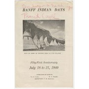
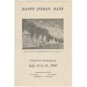
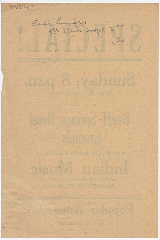
Banff Indian Days brochures
https://archives.whyte.org/en/permalink/descriptions17805
- Part Of
- Luxton family fonds
- Scope & Content
- File consists of promotional materials in the form of brochures and a flyer for Banff Indian Days. Some brochures are annotated [possibly containing edits before being published]. Contains duplicates of some items.
- Date Range
- 1938-1953
- Reference Code
- LUX / I / D3a / 6
- Description Level
- 5 / File
- GMD
- Published record
- Textual record
2 images
2 Electronic Resources
- Part Of
- Luxton family fonds
- Description Level
- 5 / File
- Fonds Number
- LUX
- Series
- I.D.3. Personal and professional : Organizations
- Sous-Fonds
- I. Norman Luxton sous-fonds
- Reference Code
- LUX / I / D3a / 6
- Responsibility
- Some items published by Crag & Canyon Presses
- Date Range
- 1938-1953
- Physical Description
- 1 cm of textual records : 12 items ; 15.6 x 24.0 cm or smaller
- Scope & Content
- File consists of promotional materials in the form of brochures and a flyer for Banff Indian Days. Some brochures are annotated [possibly containing edits before being published]. Contains duplicates of some items.
- Notes
- Copies of items may be found in LUX / II / F1 / 20. One flyer and two brochures with annotations have been digitized as other materials have been digitized and may found in LUX / II / F1 / 20.
- Reference copies of Banff Indian Days posters were included in this file, however they were stored with additional Banff Indian Day posters and may now be found at LUX / I / D3. The associated items are LUX / I / D3 / 1, 2, 4, 5, 8, 9, 10, 11, 12, 14
- Subject Access
- Activities
- Advertising
- Community events
- Banff Indian Days
- Tourism
- Geographic Access
- Banff
- Banff National Park
- Alberta
- Language
- English
- Finding Aid
- Reference copies of oversize posters are provided [now found in LUX / I / D3]
- Title Source
- Title based on contents of file
- Processing Status
- Processed
Electronic Resources
Images

This material is presented as originally created; it may contain outdated cultural descriptions and
potentially offensive content.
Read more.
The zoning map of the Town of Canmore
https://archives.whyte.org/en/permalink/catalogue23285
- Medium
- Library - Maps and blueprints (unannotated; published)
- Map
- Published Date
- 1973
- Publisher
- Calgary Regional Planning Commission
- Call Number
- C4-2.5a
- Publisher
- Calgary Regional Planning Commission
- Published Date
- 1973
- Physical Description
- 1 map
- Scale
- Scale: 1 inch = 400 feet
- Subjects
- Canmore
- Call Number
- C4-2.5a
- Collection
- Archives Library
This material is presented as originally created; it may contain outdated cultural descriptions and
potentially offensive content.
Read more.
Reference plan of town of Jasper
https://archives.whyte.org/en/permalink/catalogue23289
- Medium
- Library - Maps and blueprints (unannotated; published)
- Map
- Published Date
- 1956
- Publisher
- Dept. of Mines and Technical Surveys
- Call Number
- C4-3.2
- Publisher
- Dept. of Mines and Technical Surveys
- Published Date
- 1956
- Scale
- 1 inch - 200 feet
- Subjects
- Jasper National Park
- Accession Number
- 1115
- Call Number
- C4-3.2
- Collection
- Archives Library
This material is presented as originally created; it may contain outdated cultural descriptions and
potentially offensive content.
Read more.
Plan of Jasper Townsite/National Parks Branch
https://archives.whyte.org/en/permalink/catalogue23290
- Medium
- Library - Maps and blueprints (unannotated; published)
- Map
- Published Date
- between 1950 and 1965
- Publisher
- Ottawa : National Parks Branch
- Call Number
- C4-3.2b
- Responsibility
- The Surveys and Mapping Branch, Ottawa
- Publisher
- Ottawa : National Parks Branch
- Published Date
- between 1950 and 1965
- Physical Description
- 1 map
- Scale
- 1 inch - ca 800 feet
- Subjects
- Jasper National Park
- Notes
- Has index to buidling and attractions
- Accession Number
- 6596
- Call Number
- C4-3.2b
- Collection
- Archives Library
This material is presented as originally created; it may contain outdated cultural descriptions and
potentially offensive content.
Read more.
- Medium
- Library - Maps and blueprints (unannotated; published)
- Map
- Published Date
- 1975
- Publisher
- Surveys & Mapping Br. D.E.M.R.
- Call Number
- C5-2.5
- Publisher
- Surveys & Mapping Br. D.E.M.R.
- Published Date
- 1975
- Scale
- Sccale: 1:50,000
- Call Number
- C5-2.5
- Collection
- Archives Library
This material is presented as originally created; it may contain outdated cultural descriptions and
potentially offensive content.
Read more.
Bugaboo Glacier, British Columbia, Canada
https://archives.whyte.org/en/permalink/catalogue23305
- Medium
- Library - Maps and blueprints (unannotated; published)
- Map
- Published Date
- 1979
- Publisher
- Ottawa : Inland Waters Directorate
- Call Number
- C5-2.6e
- Publisher
- Ottawa : Inland Waters Directorate
- Published Date
- 1979
- Physical Description
- 1 map : col
- Scale
- Scale: 1 : 2,500
- Subjects
- Bugaboo Glacier
- Notes
- To be used with publication 03.4/R27/1978
- Accession Number
- 3398
- Call Number
- C5-2.6e
- Collection
- Archives Library
This material is presented as originally created; it may contain outdated cultural descriptions and
potentially offensive content.
Read more.
Reference Index-Canada 1972
https://archives.whyte.org/en/permalink/catalogue23318
- Medium
- Library - Maps and blueprints (unannotated; published)
- Map
- Published Date
- 1973
- Publisher
- Inland Waters Directorate of the Environment, Water Resources
- Call Number
- C5-5.6
- C5-5.6a
- C5-5.6b
- C5-5.6c
- C5-5.6d
- C5-5.6e
- C5-5.6f
- C5-5.6g
- C5-5.6h
- C5-5.6i
- C5-5.6j
- C5-5.6k
- Publisher
- Inland Waters Directorate of the Environment, Water Resources
- Published Date
- 1973
- Scale
- 1" - 32 miles
- Subjects
- Hydrometric Map Supplement
- Notes
- Maps: Atlantic Provinces-Discontinued Hydrometric Stations, Ontario, Prairie Provinces, Brtisih Columbia, Yukon N.W.T. Atlantic Provinces
- Accession Number
- 6500
- Call Number
- C5-5.6
- C5-5.6a
- C5-5.6b
- C5-5.6c
- C5-5.6d
- C5-5.6e
- C5-5.6f
- C5-5.6g
- C5-5.6h
- C5-5.6i
- C5-5.6j
- C5-5.6k
- Collection
- Archives Library
This material is presented as originally created; it may contain outdated cultural descriptions and
potentially offensive content.
Read more.
Lake Minnewanka hydrographic survey, Banff National Park
https://archives.whyte.org/en/permalink/catalogue23365
- Medium
- Library - Maps and blueprints (unannotated; published)
- Map
- Published Date
- 1971
- Publisher
- [Ottawa] : Dept. of Indian Affairs and Northern Development
- Call Number
- C5-6.31
- Publisher
- [Ottawa] : Dept. of Indian Affairs and Northern Development
- Published Date
- 1971
- Physical Description
- 2 maps : b & w
- Scale
- 1 inch = 1500 eet
- Subjects
- Minnewanka, Lake
- Notes
- All information taken from Plan no. F-7561 - Minnewanka sheets 1-4, Water Resources Division, Dept. of Agariculture, dated Oct. 1969.
- Drawn by [signature illegible]
- Drawing title: Tp. 26-27, Rg. 10-11. W5M. Reference no. NW B71/R51
- Accession Number
- 6901
- Call Number
- C5-6.31
- Collection
- Archives Library
This material is presented as originally created; it may contain outdated cultural descriptions and
potentially offensive content.
Read more.
Cross Country Ski Trails
https://archives.whyte.org/en/permalink/catalogue23379
- Medium
- Library - Maps and blueprints (unannotated; published)
- Map
- Published Date
- 1955
- Publisher
- Mines and Technical Surveys and Mapping Branch
- Call Number
- C6-4.2(b)
- Publisher
- Mines and Technical Surveys and Mapping Branch
- Published Date
- 1955
- Scale
- 1:190,080 1 inch to 3 miles
- Subjects
- Banff National Park
- Notes
- data compiled by Walter Batzhuber
- Accession Number
- 9000
- Call Number
- C6-4.2(b)
- Collection
- Archives Library
This material is presented as originally created; it may contain outdated cultural descriptions and
potentially offensive content.
Read more.
Hiking trails in the Lake Louise, Paradise Valley, Moraine Lake and Lake O'Hara areas
https://archives.whyte.org/en/permalink/catalogue23393
- Medium
- Library - Maps and blueprints (unannotated; published)
- Map
- Published Date
- 1959?
- Publisher
- Ottawa: Canadian Government Travel Bureau
- Call Number
- C6-4.3pb
- Publisher
- Ottawa: Canadian Government Travel Bureau
- Published Date
- 1959?
- Physical Description
- 1 map : col
- Scale
- 3/4 inch = 1 mile
- Subjects
- Lake Louise region
- Lake O'Hara region
- Notes
- Textual information on reverse. Compiled in cooperation with The National Parks of Canada.
- Info file transfer
- Call Number
- C6-4.3pb
- Collection
- Archives Library
This material is presented as originally created; it may contain outdated cultural descriptions and
potentially offensive content.
Read more.
Map of the recreation areas of the Foothills Region of Alberta
https://archives.whyte.org/en/permalink/catalogue23403
- Medium
- Library - Maps and blueprints (unannotated; published)
- Map
- Published Date
- 1975
- Publisher
- Alberta Forest Service
- Call Number
- C6-4.6(a)
- Publisher
- Alberta Forest Service
- Published Date
- 1975
- Scale
- 7/8" - 8 miles
- Notes
- Shows wilderness areas bordering BNP
- Call Number
- C6-4.6(a)
- Collection
- Archives Library
This material is presented as originally created; it may contain outdated cultural descriptions and
potentially offensive content.
Read more.
Map of the White Goat Wilderness Area with information and recreational equipment and camping requirements
https://archives.whyte.org/en/permalink/catalogue23404
- Medium
- Library - Maps and blueprints (unannotated; published)
- Map
- Published Date
- March 1975
- Publisher
- Alberta Recreation, Parks and Wildlife
- Call Number
- C6-4.6(b)
- Publisher
- Alberta Recreation, Parks and Wildlife
- Published Date
- March 1975
- Scale
- 1/2" - 1 mile
- Subjects
- White Goat Wilderness
- Alberta
- Notes
- Topo maps 83C/7W, 83C/2W, 83C/2E, 83C/6E
- Call Number
- C6-4.6(b)
- Collection
- Archives Library
This material is presented as originally created; it may contain outdated cultural descriptions and
potentially offensive content.
Read more.
Map of the Ghost River Wilderness Area with descriptive information of area and equipment and camping requirements on reverse of map
https://archives.whyte.org/en/permalink/catalogue23405
- Medium
- Library - Maps and blueprints (unannotated; published)
- Map
- Published Date
- March 1975
- Call Number
- C6-4.6(c)
- Published Date
- March 1975
- Scale
- 1/2" - 1 mile
- Subjects
- Ghost River Wilderness Area
- Notes
- For topographic maps of area see: 820/6W Lake Minnewanka sheet
- Call Number
- C6-4.6(c)
- Collection
- Archives Library
This material is presented as originally created; it may contain outdated cultural descriptions and
potentially offensive content.
Read more.
Map of the Siffleur Wilderness Area with description of area, trail access and equipment and camping requirements on reverse side of map
https://archives.whyte.org/en/permalink/catalogue23406
- Medium
- Library - Maps and blueprints (unannotated; published)
- Map
- Published Date
- Marh 1975
- Call Number
- C6-4.6(d)
- Published Date
- Marh 1975
- Scale
- 1/2" - 1 mile
- Subjects
- Siffleur Wilderness Area
- Alberta
- Notes
- For topographic maps of area see: 82N/16W, 82N/15E, 83C/1W
- Call Number
- C6-4.6(d)
- Collection
- Archives Library
This material is presented as originally created; it may contain outdated cultural descriptions and
potentially offensive content.
Read more.
- Medium
- Library - Maps and blueprints (unannotated; published)
- Map
- Published Date
- 1974
- Publisher
- Information Canada, Ottawa
- Call Number
- C6-6.1(a)
- Publisher
- Information Canada, Ottawa
- Published Date
- 1974
- Physical Description
- Colour
- Scale
- 1" - 6 1/4 miles
- Subjects
- Banff National Park
- Notes
- Banff Park information on back
- Accession Number
- 7000
- Call Number
- C6-6.1(a)
- Collection
- Archives Library
This material is presented as originally created; it may contain outdated cultural descriptions and
potentially offensive content.
Read more.
Jasper Nationa Park in the heart of the beautiful Canadian Rockies [place mat]
https://archives.whyte.org/en/permalink/catalogue23414
- Medium
- Library - Maps and blueprints (unannotated; published)
- Map
- Published Date
- 1970
- Publisher
- Jasper : The Association
- Call Number
- C6-6.2c
- Publisher
- Jasper : The Association
- Published Date
- 1970
- Physical Description
- 1 map : col
- Scale
- indeterminable
- Subjects
- Rocky Mountains, Canada - History
- Jasper National Park
- Jasper National Park Tourist Association
- Notes
- sponsored by the Jasper National Park Tourist Association
- Info file transfer
- Call Number
- C6-6.2c
- Collection
- Archives Library
This material is presented as originally created; it may contain outdated cultural descriptions and
potentially offensive content.
Read more.
Fishing bulletin for Banff National Park, nos. 2-3
https://archives.whyte.org/en/permalink/catalogue23426
- Medium
- Library - Maps and blueprints (unannotated; published)
- Map
- Published Date
- 1959-1960
- Publisher
- [Banff : s.n.]
- Call Number
- C6-8.4
- Publisher
- [Banff : s.n.]
- Published Date
- 1959-1960
- Physical Description
- 3 maps on 1 sheet : b & w
- Scale
- indeterminable
- Notes
- Textual material on reverse
- Contents: Banff-Egypt Lake Area (Section 1). - Louise-Eisenhower Area (Section 2). -- Bow Summit Area (Section 3)
- Info file transfer
- Call Number
- C6-8.4
- Collection
- Archives Library
This material is presented as originally created; it may contain outdated cultural descriptions and
potentially offensive content.
Read more.
Dominion of Canada map showing Mounted Police Station and Patrols throughout the N.W.T. during the year 1888
https://archives.whyte.org/en/permalink/catalogue23427
- Medium
- Library - Maps and blueprints (unannotated; published)
- Map
- Published Date
- 1973
- Publisher
- D.E.M.R.
- Call Number
- C6-9.1(a)
- Publisher
- D.E.M.R.
- Published Date
- 1973
- Scale
- 1" - 16 miles
- Subjects
- North West Territories
- Notes
- Also boundaries of Indian Treaties and Location of Indian Reserves
- R.C.M.P. history on back of map
- Accession Number
- 5500
- Call Number
- C6-9.1(a)
- Collection
- Archives Library
This material is presented as originally created; it may contain outdated cultural descriptions and
potentially offensive content.
Read more.
Sketch map of Vermillion Lakes used in Vermillion Lakes, Banff National Park Study by Bow Valley Naturalists with the support of Parks Canada
https://archives.whyte.org/en/permalink/catalogue23430
- Medium
- Library - Maps and blueprints (unannotated; published)
- Map
- Published Date
- Drawn (1974) using 1958, 1965 air photos. by D.J.S.
- Call Number
- C6-11.3
- Published Date
- Drawn (1974) using 1958, 1965 air photos. by D.J.S.
- Scale
- 1:13,200
- Subjects
- Vermilion Lakes
- B.N.P.
- Accession Number
- 2982
- Call Number
- C6-11.3
- Collection
- Archives Library
This material is presented as originally created; it may contain outdated cultural descriptions and
potentially offensive content.
Read more.
Fraser River, B.C.
https://archives.whyte.org/en/permalink/catalogue23432
- Medium
- Library - Maps and blueprints (unannotated; published)
- Map
- Published Date
- 1973
- Publisher
- D.E.M.P.
- Call Number
- C15.1(a)
- Publisher
- D.E.M.P.
- Published Date
- 1973
- Scale
- 1:1,000,000
- Series
- Gravity Map Series No. 153
- Subjects
- Earth Physics
- Notes
- N.T.S. No. 92
- (Bouguer Anomaly Map)
- Accession Number
- 6500
- Call Number
- C15.1(a)
- Collection
- Archives Library
This material is presented as originally created; it may contain outdated cultural descriptions and
potentially offensive content.
Read more.