Narrow Results By
- Luxton family fonds 7
- Charles Macmunn fonds 6
- Jean Knox Petrie fonds 6
- Underwood and Underwood Publishers fonds 6
- Lillian Gest fonds 5
- Dorothy Cranstone fonds 4
- Dorothy Wardle fonds 4
- Kidney family fonds 4
- Peter and Catharine Whyte fonds 4
- Archives General File Collection 3
- Edwin W. Mills fonds 3
- Jim Brewster family fonds 3
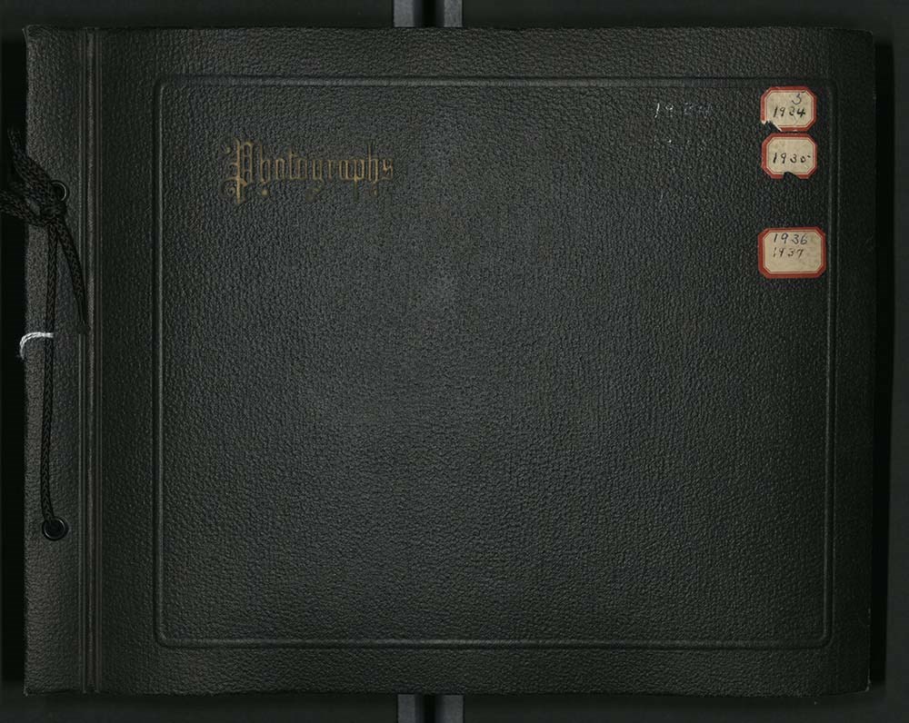
[1934-1937 Photograph Album]
https://archives.whyte.org/en/permalink/descriptions1866
- Part Of
- Lillian Gest fonds
- Scope & Content
- File pertains to a photograph album depicting trips taken by Lillian Gest, usually during the summer, from 1934-1937. The 1934 trip was part of the Alpine Club of Canada Annual Camp in northern Jasper National Park - starting in the Eremite Mountain area and working east towards Mount Edith Cavell.…
- Date Range
- 1934-1937
- Reference Code
- V225 / II / C / ii / b / PD - 10
- Description Level
- 5 / File
- GMD
- Album
- Photograph print
1 image
1 Electronic Resource
- Part Of
- Lillian Gest fonds
- Description Level
- 5 / File
- Fonds Number
- M67 / S36 / V225
- Series
- II.C. Activities / photography
- Sous-Fonds
- V225
- Sub-Series
- ii.b. Photographic material / photograph album
- Accession Number
- 5142
- Reference Code
- V225 / II / C / ii / b / PD - 10
- Date Range
- 1934-1937
- Physical Description
- 1 album (414 photographs : b&w ; 28.5 x 19 cm or smaller)
- History / Biographical
- See fonds level description
- Scope & Content
- File pertains to a photograph album depicting trips taken by Lillian Gest, usually during the summer, from 1934-1937. The 1934 trip was part of the Alpine Club of Canada Annual Camp in northern Jasper National Park - starting in the Eremite Mountain area and working east towards Mount Edith Cavell. Also includes a few photographs of mountains around the Banff town area. The 1935 trip was part of the ACC Annual Camp in the Mt. Assiniboine and East Kootenay areas. Also includes newspaper clippings pertaining to Club activities and greeting cards from Club members. The photographs associated with the Yoho Icefields from Bow Lake trip are most likely from the summer of 1936 based on greeting cards labelled as such, but very few of the photographs themselves are annotated. The remainder of the album is dedicated to the 1937 trips to Mt. Trident, Mt. Bryce, the Columbia Icefield area, Bryce and Zion, Utah, the Boulder Dam, Arizona, and Colorado. Also includes Christmas cards from 1937 from various friends and Club members. Inserts pertain to the overview/advertisements for the summer 1937 and 1938 trips that would have been sent out by Caroline Hinman in advance detailing routes, expectations, and prices ; a small photograph with a written note on the back, a letter addressed to Lillian Gest from the Springfield Television Broadcasting Corp, and a handwritten list of details pertaining to the summer 1934 trip orgainized by Caroline Hinman.
- Notes
- Blank pages not scanned. Inserts 4 and 5 are photocopies of the originals that were included with the album.
- Name Access
- Engelhard, Georgia
- Wheeler, A. O. (Arthur Oliver)
- Wheeler, Arthur Oliver
- Feuz, Ernest
- Gest, Lillian
- Hinman, Caroline
- Subject Access
- Alpine Club of Canada
- Abbot Pass Hut
- Activities
- Animals
- Bighorn Sheep
- Buildings
- Castles
- Camps
- Climbing
- Exploration
- Family and personal life
- Glaciers
- Huts
- Horses
- Horse packing
- Moose
- Mountains
- Mountaineering
- Mountain Goat
- Off the Beaten Track
- Portrait
- Scenery
- Travel
- Geographic Access
- Jasper National Park
- Banff National Park
- Yoho National Park
- Mount Assiniboine
- Lake O'Hara
- East Kootenay
- Utah
- Arizona
- Colorado
- British Columbia
- Alberta
- Canada
- United States of America
- Access Restrictions
- Microfilm copy available for reference use by appointment only.
- Language
- English
- Conservation
- Removed from plastic sleeve and rehoused in acid-free paper, tied with flat string. Locate original copies of inserts 4 & 5 and return them to PD - 10 Documents file - notes on the backs of the inserts note that the originals were moved to M67 but the documents could not be found.
- Creator
- Gest, Lillian
- Title Source
- Title based on contents of file
- Processing Status
- Processed
Electronic Resources

Images
This material is presented as originally created; it may contain outdated cultural descriptions and
potentially offensive content.
Read more.
[Abruzzi, Mount 82J/6 East, B.C.]
https://archives.whyte.org/en/permalink/catalogue23438
- Medium
- Library - Maps and blueprints (unannotated; published)
- Map
- Published Date
- 1966
- Publisher
- Dept. of Mines and Technical Surveys
- Call Number
- NTS
- 82J/6E
- Publisher
- Dept. of Mines and Technical Surveys
- Published Date
- 1966
- Physical Description
- 1 map : col
- Scale
- Scale: 1:50,000
- Relief: Contour interval 100'
- Subjects
- Mount Abruzzi
- British Columbia
- Notes
- National Topographic System
- Accession Number
- 718
- Call Number
- NTS
- 82J/6E
- Collection
- Archives Library
This material is presented as originally created; it may contain outdated cultural descriptions and
potentially offensive content.
Read more.
[Abruzzi, Mount 82J/6 West, B.C.]
https://archives.whyte.org/en/permalink/catalogue23437
- Medium
- Library - Maps and blueprints (unannotated; published)
- Map
- Published Date
- 1966
- Publisher
- Dept. of Mines and Technical Surveys
- Call Number
- NTS
- 82J/6W
- Publisher
- Dept. of Mines and Technical Surveys
- Published Date
- 1966
- Physical Description
- 1 map : col
- Scale
- Scale: 1:50,000
- Relief: Contour interval 100'
- Subjects
- Mount Abruzzi
- British Columbia
- Notes
- National Topographic System
- Accession Number
- 718
- Call Number
- NTS
- 82J/6W
- Collection
- Archives Library
This material is presented as originally created; it may contain outdated cultural descriptions and
potentially offensive content.
Read more.
- Part Of
- Jean Knox Petrie fonds
- Scope & Content
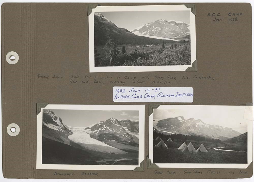
- File pertains to a photo album depicting the July 1938 ACC Camp at the Columbia Icefield,
- Date Range
- 1938
- Reference Code
- V281 / II / PD - 2
- Description Level
- 5 / File
- GMD
- Album
- Photograph print
1 image
1 Electronic Resource
- Part Of
- Jean Knox Petrie fonds
- Description Level
- 5 / File
- Fonds Number
- M237 / V281
- Series
- II : Albums
- Sous-Fonds
- V281
- Accession Number
- 7694
- Reference Code
- V281 / II / PD - 2
- Date Range
- 1938
- Physical Description
- 1 album (ca. 32 photographs : b&w ; 25 x 20 cm or smaller)
- Scope & Content
- File pertains to a photo album depicting the July 1938 ACC Camp at the Columbia Icefield,
- Name Access
- Chapman, Kathleen
- McDonald, Jean
- Petrie, Jean
- Gibson, Rex
- Feuz, Edward
- Gest, Illian
- Hind, Rob
- Walker, Hazel
- Subject Access
- Mountaineers
- Banff Jasper Highway
- Alpine Club of Canada
- Camps
- Glaciers
- Geographic Access
- Jasper National Park
- Banff
- Alberta
- Canada
- Language
- English
- Creator
- Jean Knox Petrie
- Title Source
- Title based on contents of file
- Processing Status
- Processed
Electronic Resources
Images
This material is presented as originally created; it may contain outdated cultural descriptions and
potentially offensive content.
Read more.
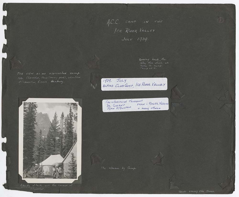
ACC Camp in the Ice River Valley
https://archives.whyte.org/en/permalink/descriptions55146
- Part Of
- Jean Knox Petrie fonds
- Scope & Content
- File pertains to a photo album depicting the July 1939 ACC Camp at the Ice River Valley
- Date Range
- 1939
- Reference Code
- V281 / II / PD - 4
- Description Level
- 5 / File
- GMD
- Album
- Photograph print
1 image
1 Electronic Resource
- Part Of
- Jean Knox Petrie fonds
- Description Level
- 5 / File
- Fonds Number
- M237 / V281
- Series
- II : Albums
- Sous-Fonds
- V281
- Accession Number
- 7694
- Reference Code
- V281 / II / PD - 4
- Date Range
- 1939
- Physical Description
- 1 album (ca. 32 photographs : b&w ; 25 x 20 cm or smaller)
- Scope & Content
- File pertains to a photo album depicting the July 1939 ACC Camp at the Ice River Valley
- Notes
- Albums with black pages were likely originally bound together as a single album, however gaps in page numbers imply that pages are missing from the complete work.
- Name Access
- Chapman, Kathleen
- McDonald, Jean
- Petrie, Jean
- Gibson, Rex
- Feuz, Edward
- Gest, Illian
- Hind, Rob
- Walker, Hazel
- Subject Access
- Mountaineers
- Banff Jasper Highway
- Alpine Club of Canada
- Camps
- Glaciers
- Geographic Access
- Jasper National Park
- Banff
- Alberta
- Canada
- Language
- English
- Creator
- Jean Knox Petrie
- Title Source
- Title based on contents of file
- Processing Status
- Processed
Electronic Resources
Images
This material is presented as originally created; it may contain outdated cultural descriptions and
potentially offensive content.
Read more.
[Adams Lookout, Alberta]
https://archives.whyte.org/en/permalink/catalogue23439
- Medium
- Library - Maps and blueprints (unannotated; published)
- Map
- Published Date
- 1962
- Publisher
- Dept. of Mines & Technical Surveys
- Call Number
- NTS
- 83E/10E
- Publisher
- Dept. of Mines & Technical Surveys
- Published Date
- 1962
- Scale
- Scale: 1:50,000
- Subjects
- Adams Lookout
- Alberta
- Notes
- National Topographic System
- Accession Number
- 12000
- Call Number
- NTS
- 83E/10E
- Collection
- Archives Library
This material is presented as originally created; it may contain outdated cultural descriptions and
potentially offensive content.
Read more.
[Adams Lookout, Alberta]
https://archives.whyte.org/en/permalink/catalogue23440
- Medium
- Library - Maps and blueprints (unannotated; published)
- Map
- Published Date
- 1962
- Publisher
- Dept. of Mines and Technical Surveys
- Call Number
- NTS
- 83W/10W
- Publisher
- Dept. of Mines and Technical Surveys
- Published Date
- 1962
- Scale
- Scale: 1:50,000
- Subjects
- Adams Lookout
- Alberta
- Notes
- National Topographic System
- Accession Number
- 12000
- Call Number
- NTS
- 83W/10W
- Collection
- Archives Library
This material is presented as originally created; it may contain outdated cultural descriptions and
potentially offensive content.
Read more.
[Adams Plateau 82M/4 East, B.C.]
https://archives.whyte.org/en/permalink/catalogue23441
- Medium
- Library - Maps and blueprints (unannotated; published)
- Map
- Published Date
- 1961
- Publisher
- Department of Mines and Technical Surveys
- Call Number
- NTS
- 82M/4E
- Publisher
- Department of Mines and Technical Surveys
- Published Date
- 1961
- Physical Description
- 1 map : col
- Scale
- Scale: 1:50,000
- Relief: Contour interval 100 ft.
- Subjects
- Adams Plateau
- British Columbia
- Notes
- National Topographic System
- Accession Number
- 7000
- Call Number
- NTS
- 82M/4E
- Collection
- Archives Library
This material is presented as originally created; it may contain outdated cultural descriptions and
potentially offensive content.
Read more.
[Adams Plateau 82M/4 West, B.C.]
https://archives.whyte.org/en/permalink/catalogue23442
- Medium
- Library - Maps and blueprints (unannotated; published)
- Map
- Published Date
- 1961
- Publisher
- Department of Mines and Technical Surveys
- Call Number
- NTS
- 82M/4W
- Publisher
- Department of Mines and Technical Surveys
- Published Date
- 1961
- Physical Description
- 1 map : col
- Scale
- Scale: 1:50,000
- Relief: Contour interval 100 ft.
- Subjects
- Adams Plateau
- British Columbia
- Notes
- National Topographic System
- Accession Number
- 7000
- Call Number
- NTS
- 82M/4W
- Collection
- Archives Library
This material is presented as originally created; it may contain outdated cultural descriptions and
potentially offensive content.
Read more.
[Adams River 82M/11 East, B.C.]
https://archives.whyte.org/en/permalink/catalogue23443
- Medium
- Library - Maps and blueprints (unannotated; published)
- Map
- Published Date
- 1961
- Publisher
- Dept. of Mines and Technical Surveys
- Call Number
- NTS
- 82M/11E
- Publisher
- Dept. of Mines and Technical Surveys
- Published Date
- 1961
- Physical Description
- 1 map : col
- Scale
- Scale: 1:50,000
- Relief: Contour interval 100 ft.
- Subjects
- Adams River
- British Columbia
- Notes
- National Topographic System
- Accession Number
- 3000
- Call Number
- NTS
- 82M/11E
- Collection
- Archives Library
This material is presented as originally created; it may contain outdated cultural descriptions and
potentially offensive content.
Read more.
[Adams River 82M/11 West, B.C.]
https://archives.whyte.org/en/permalink/catalogue23444
- Medium
- Library - Maps and blueprints (unannotated; published)
- Map
- Published Date
- 1961
- Publisher
- Dept. of Mines and Technical Surveys
- Call Number
- NTS
- 82M/11W
- Publisher
- Dept. of Mines and Technical Surveys
- Published Date
- 1961
- Physical Description
- 1 map : col
- Scale
- Scale: 1:50,000
- Relief: Contour interval 100 ft.
- Subjects
- Adams River
- British Columbia
- Notes
- National Topographic System
- Accession Number
- 3000
- Call Number
- NTS
- 82M/11W
- Collection
- Archives Library
This material is presented as originally created; it may contain outdated cultural descriptions and
potentially offensive content.
Read more.
[Africa, Northwestern]
https://archives.whyte.org/en/permalink/catalogue24841
- Medium
- Library - Maps and blueprints (unannotated; published)
- Map
- Published Date
- 1966
- Publisher
- National Geographic Society
- Call Number
- C13-7.3
- Publisher
- National Geographic Society
- Published Date
- 1966
- Scale
- Scale: 125 miles to 1 inch
- Relief: Bench marks
- Subjects
- Northwestern Africa
- Call Number
- C13-7.3
- Collection
- Archives Library
This material is presented as originally created; it may contain outdated cultural descriptions and
potentially offensive content.
Read more.
[Africa, Southern]
https://archives.whyte.org/en/permalink/catalogue24840
- Medium
- Library - Maps and blueprints (unannotated; published)
- Map
- Published Date
- 1962
- Publisher
- National Geographic Society
- Call Number
- C13-7.2
- Publisher
- National Geographic Society
- Published Date
- 1962
- Scale
- Scale: 125 miles to 1 inch
- Relief: bench marks
- Subjects
- Southern Africa
- Accession Number
- 495
- Call Number
- C13-7.2
- Collection
- Archives Library
This material is presented as originally created; it may contain outdated cultural descriptions and
potentially offensive content.
Read more.
[Albas 82M/3 East, B.C.]
https://archives.whyte.org/en/permalink/catalogue23445
- Medium
- Library - Maps and blueprints (unannotated; published)
- Map
- Published Date
- 1961
- Publisher
- Dept. of Mines and Technical Surveys
- Call Number
- NTS
- 82M/3E
- Publisher
- Dept. of Mines and Technical Surveys
- Published Date
- 1961
- Physical Description
- 1 map : black and white
- Scale
- Scale: 1:50,000
- Relief: Contour interval 100 ft.
- Subjects
- Albas
- British Columbia
- Notes
- National Topographic System
- Accession Number
- 3000
- Call Number
- NTS
- 82M/3E
- Collection
- Archives Library
This material is presented as originally created; it may contain outdated cultural descriptions and
potentially offensive content.
Read more.
[Albas 82M/3 West, B.C.]
https://archives.whyte.org/en/permalink/catalogue23446
- Medium
- Library - Maps and blueprints (unannotated; published)
- Map
- Published Date
- 1961
- Publisher
- Dept. of Mines and Technical Surveys
- Call Number
- NTS
- 82M/3W
- Publisher
- Dept. of Mines and Technical Surveys
- Published Date
- 1961
- Physical Description
- 1 map : black and white
- Scale
- Scale: 1:50,000
- Relief: Contour interval 100 ft.
- Subjects
- Albas
- British Columbia
- Notes
- National Topographic System
- Accession Number
- 3000
- Call Number
- NTS
- 82M/3W
- Collection
- Archives Library
This material is presented as originally created; it may contain outdated cultural descriptions and
potentially offensive content.
Read more.
[Alberta] 2 sections
https://archives.whyte.org/en/permalink/catalogue24382
- Medium
- Library - Maps and blueprints (unannotated; published)
- Map
- Published Date
- 1965
- Publisher
- Dept. of Highways, Alberta
- Call Number
- C9-1.3(a)
- Publisher
- Dept. of Highways, Alberta
- Published Date
- 1965
- Physical Description
- 1 map : col
- Scale
- Scale: 12 miles: 1 inch
- Accession Number
- 673
- Call Number
- C9-1.3(a)
- Collection
- Archives Library
This material is presented as originally created; it may contain outdated cultural descriptions and
potentially offensive content.
Read more.
[Alberta] 2 sections
https://archives.whyte.org/en/permalink/catalogue24383
- Medium
- Library - Maps and blueprints (unannotated; published)
- Map
- Published Date
- 1967
- Publisher
- Dept. of Highways, Alberta
- Call Number
- C9-1.3(b)
- Publisher
- Dept. of Highways, Alberta
- Published Date
- 1967
- Physical Description
- 1 map : col
- Scale
- Scale: 12 miles: 1 inch
- Subjects
- Alberta
- Accession Number
- 673
- Call Number
- C9-1.3(b)
- Collection
- Archives Library
This material is presented as originally created; it may contain outdated cultural descriptions and
potentially offensive content.
Read more.
[Alberta] Department of Highways and Transport District Boundaries
https://archives.whyte.org/en/permalink/catalogue21405
- Medium
- Library - Maps and blueprints (unannotated; published)
- Map
- Published Date
- 1969
- Publisher
- Surveys Branch, Department of Highways and Transport
- Call Number
- C9-5.8
- Publisher
- Surveys Branch, Department of Highways and Transport
- Published Date
- 1969
- Subjects
- Alberta
- Notes
- Legend in colour
- Accession Number
- SG7500
- Call Number
- C9-5.8
- Collection
- Archives Library
This material is presented as originally created; it may contain outdated cultural descriptions and
potentially offensive content.
Read more.
Alberta historical photographs
https://archives.whyte.org/en/permalink/descriptions55340
- Part Of
- Luxton family fonds
- Scope & Content
- Album consists of 14 photographs and accompanying notes pertaining to various historical events in Alberta. Photographs in album pertain to the Ranchmen's Club in Calgary; an unidentified Stoney Nakoda chief receiving royalty payments for oil extraction in 1929; a group of police officers gathered …
- Date Range
- [1955-1960]
- Reference Code
- LUX / II / E / PD - 6
- Description Level
- 5 / File
- GMD
- Album
- Photograph
- Photograph print
- Part Of
- Luxton family fonds
- Description Level
- 5 / File
- Fonds Number
- LUX
- Series
- LUX / II / E : Travel and home records
- Sous-Fonds
- LUX / II : Eleanor Luxton sous-fonds
- Accession Number
- LUX
- Reference Code
- LUX / II / E / PD - 6
- Date Range
- [1955-1960]
- Physical Description
- 1 album (14 photographs : b&w ; 20 x 25 cm)
- Scope & Content
- Album consists of 14 photographs and accompanying notes pertaining to various historical events in Alberta. Photographs in album pertain to the Ranchmen's Club in Calgary; an unidentified Stoney Nakoda chief receiving royalty payments for oil extraction in 1929; a group of police officers gathered outside of a building [possibly the North-West Mounted Police Barracks in Canmore]; a cattle ranch, possibly located on a Blackfoot reserve; and other related subjects.
- Notes
- Photographs are copies of older images which were reproduced by Eleanor Luxton, ca.1955-1960. Dates and ownership details of original images is unknown.
- Subject Access
- Research
- History
- Animals
- Club
- Community life
- Environment
- Indigenous Peoples
- First Nations
- Land, settlement and immigration
- Natural resources
- Oil
- Organizations
- Ranchers and ranching
- Ranches
- Stoney Nakoda First Nations
- Geographic Access
- Canada
- Alberta
- Calgary
- Morley
- Canmore
- Reproduction Restrictions
- Copyright status unknown
- Language
- English
- Category
- Environment
- First nations
- Indigenous Peoples
- Land, settlement and immigration
- Natural resources
- Title Source
- Title based on contents of file
- Processing Status
- Processed
This material is presented as originally created; it may contain outdated cultural descriptions and
potentially offensive content.
Read more.
[Alberta] Population by Township and Incorporated Places, 1966 Census of Canada
https://archives.whyte.org/en/permalink/catalogue24425
- Medium
- Library - Maps and blueprints (unannotated; published)
- Map
- Published Date
- 1966
- Publisher
- Surveys Branch, Dept. of Hwys
- Call Number
- C9-5.2(b)
- Publisher
- Surveys Branch, Dept. of Hwys
- Published Date
- 1966
- Physical Description
- 1 map : black and white
- Scale
- Scale: 12 miles: 1 inch
- Subjects
- Alberta
- Alberta-Population
- Notes
- Xerox copy
- Accession Number
- AG7500
- Call Number
- C9-5.2(b)
- Collection
- Archives Library
This material is presented as originally created; it may contain outdated cultural descriptions and
potentially offensive content.
Read more.