Narrow Results By
[Anahim Lake, B.C.] Canada Land Inventory Map, Land capability for wildlife-ungulates
https://archives.whyte.org/en/permalink/catalogue24004
- Medium
- Library - Maps and blueprints (unannotated; published)
- Map
- Published Date
- 1971
- Publisher
- Dept. of Energy, Mines and Resources
- Call Number
- NTS
- 93C
- Publisher
- Dept. of Energy, Mines and Resources
- Published Date
- 1971
- Physical Description
- 1 map : col
- Scale
- Scale: 1:250,000
- Subjects
- Anahim Lake
- British Columbia
- Accession Number
- 4000
- Call Number
- NTS
- 93C
- Collection
- Archives Library
This material is presented as originally created; it may contain outdated cultural descriptions and
potentially offensive content.
Read more.
[Angus Horne Lake 83D/5 B.C.]
https://archives.whyte.org/en/permalink/catalogue23450
- Medium
- Library - Maps and blueprints (unannotated; published)
- Map
- Published Date
- 1972
- Publisher
- Department of Energy, Mines and Resources
- Call Number
- NTS
- 83D/5
- Publisher
- Department of Energy, Mines and Resources
- Published Date
- 1972
- Physical Description
- 1 map : col
- Scale
- Scale: 1:50,000
- Relief: Contour interval 100 ft.
- Subjects
- Angus Horne Lake
- British Columbia
- Notes
- National Topographic System
- Accession Number
- 7000
- Call Number
- NTS
- 83D/5
- Collection
- Archives Library
This material is presented as originally created; it may contain outdated cultural descriptions and
potentially offensive content.
Read more.
[Azure River 83D/12 B.C.]
https://archives.whyte.org/en/permalink/catalogue23458
- Medium
- Library - Maps and blueprints (unannotated; published)
- Map
- Published Date
- 1972
- Publisher
- Department of Energy, Mines and Resources
- Call Number
- NTS
- 83D/12
- Publisher
- Department of Energy, Mines and Resources
- Published Date
- 1972
- Physical Description
- 1 map : col
- Scale
- Scale: 1:50,000
- Relief: Contour interval 100 ft.
- Subjects
- Azure River
- British Columbia
- Notes
- National Topographic System
- Accession Number
- 7000
- 7030
- Call Number
- NTS
- 83D/12
- Collection
- Archives Library
This material is presented as originally created; it may contain outdated cultural descriptions and
potentially offensive content.
Read more.
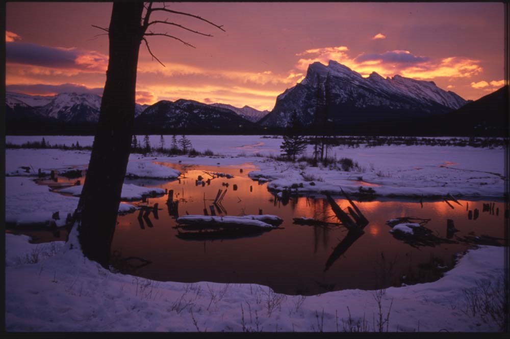
Banff "active best"
https://archives.whyte.org/en/permalink/descriptions56444
- Part Of
- Douglas Leighton fonds
- Scope & Content
- File consists of photographs compiled by Douglas Leighton for publication. Includes photographs of landscapes, lakes, mountains, hotel, tourists, waterfalls and glaciers.
- Date Range
- 1978
- 1979
- 1984
- 1986 - 1993
- 1995
- 1996
- Reference Code
- V222 / VI / C / 2 / NS - 1 to 155
- Description Level
- 5 / File
- GMD
- Photograph
- Transparency
- Part Of
- Douglas Leighton fonds
- Description Level
- 5 / File
- Fonds Number
- M133
- V222
- Series
- V222 / VI : Publication
- Sous-Fonds
- V222
- Sub-Series
- V222 / VI / C: Compiled for publication
- Accession Number
- 2020.24
- Reference Code
- V222 / VI / C / 2 / NS - 1 to 155
- Date Range
- 1978
- 1979
- 1984
- 1986 - 1993
- 1995
- 1996
- Physical Description
- 155 photographs : col. slides ; 35 mm
- Scope & Content
- File consists of photographs compiled by Douglas Leighton for publication. Includes photographs of landscapes, lakes, mountains, hotel, tourists, waterfalls and glaciers.
- Name Access
- Leighton, Douglas
- Subject Access
- British Columbia
- Geographic Access
- Alberta
- Lake Louise, AB
- Banff National Park
- Banff
- Exshaw
- Canmore
- Language
- English
- Creator
- Douglas Leighton
- Title Source
- Title based on contents of file
- Processing Status
- Processed
This material is presented as originally created; it may contain outdated cultural descriptions and
potentially offensive content.
Read more.
B.C. Highway map
https://archives.whyte.org/en/permalink/catalogue24515
- Medium
- Library - Maps and blueprints (unannotated; published)
- Map
- Published Date
- 1975-76
- Publisher
- Lawson Graphics (Pacific)
- Call Number
- C10-1.4
- Publisher
- Lawson Graphics (Pacific)
- Published Date
- 1975-76
- Scale
- Scale: 1 inch - 34 miles
- Subjects
- British Columbia
- Highways
- Call Number
- C10-1.4
- Collection
- Archives Library
This material is presented as originally created; it may contain outdated cultural descriptions and
potentially offensive content.
Read more.
[British Columbia Highway] Highway map
https://archives.whyte.org/en/permalink/catalogue24514
- Medium
- Library - Maps and blueprints (unannotated; published)
- Map
- Published Date
- 1975-76
- Publisher
- Grant-Mann Lithographers Ltd.
- Call Number
- C10-1.3
- Publisher
- Grant-Mann Lithographers Ltd.
- Published Date
- 1975-76
- Scale
- Scale: 1 inch - 34 miles
- Subjects
- British Columbia
- Highways
- Call Number
- C10-1.3
- Collection
- Archives Library
This material is presented as originally created; it may contain outdated cultural descriptions and
potentially offensive content.
Read more.
[Bute Inlet, B.C.] Canada Land Inventory Map, Land capability for wildlife-ungulates
https://archives.whyte.org/en/permalink/catalogue24016
- Medium
- Library - Maps and blueprints (unannotated; published)
- Map
- Published Date
- 1971
- Publisher
- Dept. of Energy, Mines and Resouces
- Call Number
- NTS
- 92K
- Publisher
- Dept. of Energy, Mines and Resouces
- Published Date
- 1971
- Physical Description
- 1 map : col
- Scale
- Scale: 1:250,000
- Subjects
- Bute Inlet
- British Columbia
- Accession Number
- 4000
- Call Number
- NTS
- 92K
- Collection
- Archives Library
This material is presented as originally created; it may contain outdated cultural descriptions and
potentially offensive content.
Read more.
Canadian Rockies and other "active best"
https://archives.whyte.org/en/permalink/descriptions56446
- Part Of
- Douglas Leighton fonds
- Scope & Content
- File consists of photographs compiled by Douglas Leighton for publication. Includes photographs of landscapes, cityscapes, lakes, mountains, hotel, tourists, plants, waterfalls and glaciers.
- Date Range
- 1978
- 1981 - 1983
- 1987
- 1988
- 1990
- 1993 - 1995
- 1997
- 1998
- 2003
- 2006
- 2007
- Reference Code
- V222 / VI / C / 4 / NS - 1 to 119
- Description Level
- 5 / File
- GMD
- Photograph
- Transparency
4 images
- Part Of
- Douglas Leighton fonds
- Description Level
- 5 / File
- Fonds Number
- M133
- V222
- Series
- V222 / VI : Publication
- Sous-Fonds
- V222
- Sub-Series
- V222 / VI / C: Compiled for publication
- Accession Number
- 2020.24
- Reference Code
- V222 / VI / C / 4 / NS - 1 to 119
- Date Range
- 1978
- 1981 - 1983
- 1987
- 1988
- 1990
- 1993 - 1995
- 1997
- 1998
- 2003
- 2006
- 2007
- Physical Description
- 119 photographs : col. slides ; 35 mm
- Scope & Content
- File consists of photographs compiled by Douglas Leighton for publication. Includes photographs of landscapes, cityscapes, lakes, mountains, hotel, tourists, plants, waterfalls and glaciers.
- Name Access
- Leighton, Douglas
- Subject Access
- British Columbia
- Geographic Access
- Alberta
- British Columbia
- Banff National Park
- Banff
- Calgary, AB
- Edmonton, AB
- Kootenay, BC
- Yoho National Park
- Jasper National Park
- Cranbrook, BC
- Vancouver, BC
- Language
- English
- Creator
- Douglas Leighton
- Title Source
- Title based on contents of file
- Processing Status
- Processed
Images
This material is presented as originally created; it may contain outdated cultural descriptions and
potentially offensive content.
Read more.
[Chase 82L/13 B.C.]
https://archives.whyte.org/en/permalink/catalogue23547
- Medium
- Library - Maps and blueprints (unannotated; published)
- Map
- Published Date
- 1973
- Publisher
- Department of Energy, Mines and Resources
- Call Number
- NTS
- 82L/I3
- Publisher
- Department of Energy, Mines and Resources
- Published Date
- 1973
- Physical Description
- 1 map : col
- Scale
- Scale: 1:50,000
- Relief: Contour interval 100 ft.
- Subjects
- Chase
- British Columbia
- Notes
- National Topographic System
- Accession Number
- 7000
- Call Number
- NTS
- 82L/I3
- Collection
- Archives Library
This material is presented as originally created; it may contain outdated cultural descriptions and
potentially offensive content.
Read more.
[Cottonwood River, B.C.] Canada Land Inventory Map, Land Capability for Forestry
https://archives.whyte.org/en/permalink/catalogue23961
- Medium
- Library - Maps and blueprints (unannotated; published)
- Map
- Published Date
- 1972
- Publisher
- Department of Energy, Mines and Resources
- Call Number
- NTS
- 93G/SE
- Publisher
- Department of Energy, Mines and Resources
- Published Date
- 1972
- Physical Description
- 1 map : col
- Scale
- Scale: 1:125,000
- Subjects
- Cottonwood River
- British Columbia
- Accession Number
- 7000
- Call Number
- NTS
- 93G/SE
- Collection
- Archives Library
This material is presented as originally created; it may contain outdated cultural descriptions and
potentially offensive content.
Read more.
[Cranbrook, B.C.] Canada Land Inventory Map, Land Capability for Forestry
https://archives.whyte.org/en/permalink/catalogue23962
- Medium
- Library - Maps and blueprints (unannotated; published)
- Map
- Published Date
- 1972
- Publisher
- Department of Energy, Mines and Resources
- Call Number
- NTS
- 82G/NW, NE
- Publisher
- Department of Energy, Mines and Resources
- Published Date
- 1972
- Physical Description
- 1 map : col
- Scale
- Scale: 1:125,000
- Subjects
- Cranbrook
- British Columbia
- Accession Number
- 7000
- Call Number
- NTS
- 82G/NW, NE
- Collection
- Archives Library
This material is presented as originally created; it may contain outdated cultural descriptions and
potentially offensive content.
Read more.
[Elko, B.C.] Canada Land Inventory Map, Land Capability for Forestry
https://archives.whyte.org/en/permalink/catalogue23963
- Medium
- Library - Maps and blueprints (unannotated; published)
- Map
- Published Date
- 1972
- Publisher
- Dept. of Energy, Mines and Resources
- Call Number
- NTS
- 82G/SW
- Publisher
- Dept. of Energy, Mines and Resources
- Published Date
- 1972
- Physical Description
- 1 map : col
- Scale
- Scale: 1:125,000
- Subjects
- Elko
- British Columbia
- Accession Number
- 6500
- Call Number
- NTS
- 82G/SW
- Collection
- Archives Library
This material is presented as originally created; it may contain outdated cultural descriptions and
potentially offensive content.
Read more.
[Flathead, B.C.] Canada Land Inventory Map, Land Capability for Forestry
https://archives.whyte.org/en/permalink/catalogue23964
- Medium
- Library - Maps and blueprints (unannotated; published)
- Map
- Published Date
- 1972
- Publisher
- Dept. of Energy, Mines and Resources
- Call Number
- NTS
- 82G/SE
- Publisher
- Dept. of Energy, Mines and Resources
- Published Date
- 1972
- Physical Description
- 1 map : col
- Scale
- Scale: 1:125,000
- Subjects
- Flathead
- British Columbia
- Accession Number
- 6500
- Call Number
- NTS
- 82G/SE
- Collection
- Archives Library
This material is presented as originally created; it may contain outdated cultural descriptions and
potentially offensive content.
Read more.
[Invermere, B.C.] Canada Land Inventory Map, Soil Capability for Agriculture
https://archives.whyte.org/en/permalink/catalogue23965
- Medium
- Library - Maps and blueprints (unannotated; published)
- Map
- Published Date
- 1972
- Publisher
- Department of Energy, Mines and Resources
- Call Number
- NTS
- 82K/NE
- Publisher
- Department of Energy, Mines and Resources
- Published Date
- 1972
- Physical Description
- 1 map : col
- Scale
- Scale: 1:125,000
- Subjects
- Invermere
- British Columbia
- Accession Number
- 4000
- Call Number
- NTS
- 82K/NE
- Collection
- Archives Library
This material is presented as originally created; it may contain outdated cultural descriptions and
potentially offensive content.
Read more.
[Kiwa Creek 83D/13, B.C.]
https://archives.whyte.org/en/permalink/catalogue23704
- Medium
- Library - Maps and blueprints (unannotated; published)
- Map
- Published Date
- 1973
- Publisher
- Department of Energy, Mines and Resources
- Call Number
- NTS
- 83D/13
- Publisher
- Department of Energy, Mines and Resources
- Published Date
- 1973
- Physical Description
- 1 map : col
- Scale
- Scale: 1:50,000
- Relief: Contour interval 100 ft.
- Subjects
- Kiwa Creek
- British Columbia
- Notes
- National Topographic System
- Accession Number
- 7000
- Call Number
- NTS
- 83D/13
- Collection
- Archives Library
This material is presented as originally created; it may contain outdated cultural descriptions and
potentially offensive content.
Read more.
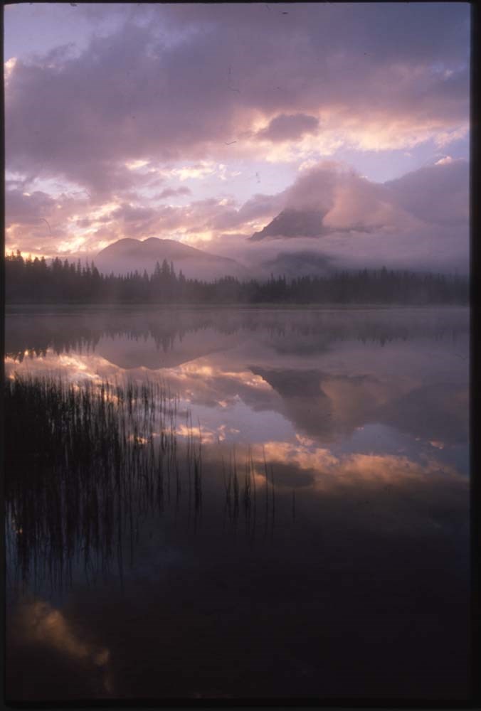
Moraine Lake and Lake Louise "active best"
https://archives.whyte.org/en/permalink/descriptions56443
- Part Of
- Douglas Leighton fonds
- Scope & Content
- File consists of photographs compiled by Douglas Leighton for publication. Includes photographs of landscapes, lakes, mountains, hotel, tourists, people climbing, and flowers
- Date Range
- 1979
- 1981
- 1984 - 1991
- Reference Code
- V222 / VI / C / 1 / NS - 1 to 124
- Description Level
- 5 / File
- GMD
- Photograph
- Transparency
- Part Of
- Douglas Leighton fonds
- Description Level
- 5 / File
- Fonds Number
- M133
- V222
- Series
- V222 / VI : Publication
- Sous-Fonds
- V222
- Sub-Series
- V222 / VI / C: Compiled for publication
- Accession Number
- 2020.24
- Reference Code
- V222 / VI / C / 1 / NS - 1 to 124
- Date Range
- 1979
- 1981
- 1984 - 1991
- Physical Description
- 124 photographs : col. slides ; 35 mm
- Scope & Content
- File consists of photographs compiled by Douglas Leighton for publication. Includes photographs of landscapes, lakes, mountains, hotel, tourists, people climbing, and flowers
- Name Access
- Leighton, Douglas
- Subject Access
- British Columbia
- Geographic Access
- Alberta
- Lake Louise, AB
- Banff National Park
- Moraine Lake, AB
- Language
- English
- Creator
- Douglas Leighton
- Title Source
- Title based on contents of file
- Processing Status
- Processed
This material is presented as originally created; it may contain outdated cultural descriptions and
potentially offensive content.
Read more.
[Mount Assiniboine 82J/NW, B.C.]
https://archives.whyte.org/en/permalink/catalogue23990
- Medium
- Library - Maps and blueprints (unannotated; published)
- Map
- Published Date
- 1971
- Publisher
- Dept. of Lands and Forests & Water Resources
- Call Number
- NTS
- 82J/NW
- Publisher
- Dept. of Lands and Forests & Water Resources
- Published Date
- 1971
- Physical Description
- 1 map : col
- Scale
- Scale: 1:126,720
- Relief: Contour Interval 100 ft.
- Subjects
- Mount Assiniboine
- British Columbia
- Notes
- National Topographic System
- Accession Number
- 3000
- Call Number
- NTS
- 82J/NW
- Collection
- Archives Library
This material is presented as originally created; it may contain outdated cultural descriptions and
potentially offensive content.
Read more.
[Mount Assiniboine, B.C.] Canada Land Inventory Map, Land Capability for Forestry
https://archives.whyte.org/en/permalink/catalogue23966
- Medium
- Library - Maps and blueprints (unannotated; published)
- Map
- Published Date
- 1973
- Publisher
- Department of Energy, Mines and Resources
- Call Number
- NTS
- 82J/NW
- Publisher
- Department of Energy, Mines and Resources
- Published Date
- 1973
- Physical Description
- 1 map : col
- Scale
- Scale: 1:125,000
- Subjects
- Mount Assiniboine
- British Columbia
- Accession Number
- 7000
- Call Number
- NTS
- 82J/NW
- Collection
- Archives Library
This material is presented as originally created; it may contain outdated cultural descriptions and
potentially offensive content.
Read more.
[Mount Assiniboine, B.C.] Canada Land Inventory Map, Soil Capability for Agriculture
https://archives.whyte.org/en/permalink/catalogue24099
- Medium
- Library - Maps and blueprints (unannotated; published)
- Map
- Published Date
- 1972
- Publisher
- Dept. of Energy, Mines and Resources
- Call Number
- NTS
- 82J/NW
- Publisher
- Dept. of Energy, Mines and Resources
- Published Date
- 1972
- Physical Description
- 1 map : col
- Scale
- Scake: 1:250,000
- Subjects
- Mount Assiniboine
- British Columbia
- Accession Number
- 6000
- Call Number
- NTS
- 82J/NW
- Collection
- Archives Library
This material is presented as originally created; it may contain outdated cultural descriptions and
potentially offensive content.
Read more.
[Nass River, B.C.] Canada Land Inventory Map, Land capability for wildlife-waterfowl
https://archives.whyte.org/en/permalink/catalogue24110
- Medium
- Library - Maps and blueprints (unannotated; published)
- Map
- Published Date
- 1970
- Publisher
- Dept. of Energy, Mines and Resources
- Call Number
- NTS
- 103PQ
- Publisher
- Dept. of Energy, Mines and Resources
- Published Date
- 1970
- Physical Description
- 1 map : col
- Scale
- Scale: 1:250,000
- Subjects
- Nass River
- British Columbia
- Accession Number
- 4000
- Call Number
- NTS
- 103PQ
- Collection
- Archives Library
This material is presented as originally created; it may contain outdated cultural descriptions and
potentially offensive content.
Read more.