Narrow Results By
Report of the Commission Appointed to Delimit the Boundary between the Provinces of Alberta and British Columbia - Part I - from 1913 to 1916
https://archives.whyte.org/en/permalink/catalogue25065
- Medium
- Library - Book (including soft-cover and pamphlets)
- Published Date
- 1917
- Author
- Alberta and British Columbia Boundary Commission
- Publisher
- Ottawa : Kings Printer
- Call Number
- 03.2 Al1ab A Atlas oversize and report copy 3 reference Part I 1913-1916
- Responsibility
- R.W. Cautley
- J.N Wallace
- A.O. Wheeler
- Publisher
- Ottawa : Kings Printer
- Published Date
- 1917
- Physical Description
- 1 atlas : illustrations ; 1 report
- Subjects
- Monuments and historic markers
- Surveys
- Boundaries
- Alberta
- British Columbia
- British Columbia - Boundaries
- British Columbia - Surveys and Mapping
- Alberta - B.C. Boundary
- Alberta - Boundaries
- Alberta British Columbia Boundary Commission
- Wheeler, Arthur Oliver
- Cautley, Richard William
- Wallace, James Nevin
- Atlases
- Maps
- Notes
- Report and oversize atlas
- Accession Number
- 8114
- Call Number
- 03.2 Al1ab A Atlas oversize and report copy 3 reference Part I 1913-1916
- Collection
- Archives Library
This material is presented as originally created; it may contain outdated cultural descriptions and
potentially offensive content.
Read more.
Kootenay district, B.C.
https://archives.whyte.org/en/permalink/catalogue24519
- Medium
- Library - Maps and blueprints (unannotated; published)
- Map
- Published Date
- 1915
- Publisher
- Department of Lands, B.C.
- Call Number
- C10-2.3
- Publisher
- Department of Lands, B.C.
- Published Date
- 1915
- Scale
- Scale: 1:500,000
- Accession Number
- 400
- Call Number
- C10-2.3
- Collection
- Archives Library
This material is presented as originally created; it may contain outdated cultural descriptions and
potentially offensive content.
Read more.
[Yale District, Southern B.C.] British Columbia
https://archives.whyte.org/en/permalink/catalogue24518
- Medium
- Library - Maps and blueprints (unannotated; published)
- Map
- Published Date
- 1912
- Publisher
- Dept. of Lands & Works, B.C.
- Call Number
- C10-2.2
- Publisher
- Dept. of Lands & Works, B.C.
- Published Date
- 1912
- Scale
- Scale: 1 inch - 8 miles
- Accession Number
- 400
- Call Number
- C10-2.2
- Collection
- Archives Library
This material is presented as originally created; it may contain outdated cultural descriptions and
potentially offensive content.
Read more.
Banff in the Canadian Rockies and the glaciers of the Selkirks
https://archives.whyte.org/en/permalink/catalogue15311
- Medium
- Library - Book (including soft-cover and pamphlets)
- Published Date
- 1900
- Call Number
- 08.3 B22c Pam
- Responsibility
- Canadian Pacific Railway
- Published Date
- 1900
- Subjects
- Banff
- Banff Springs Hotel
- Bow Valley
- Field
- Fraser River
- Hot springs
- Lake Louise
- Minnewanka, Lake
- Revelstoke
- Vancouver, British Columbia
- Vermilion Lakes
- Accession Number
- 2014.8385
- Call Number
- 08.3 B22c Pam
- Collection
- Archives Library
This material is presented as originally created; it may contain outdated cultural descriptions and
potentially offensive content.
Read more.
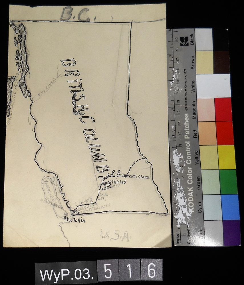
- Date
- 1917 – 1966
- Medium
- graphite; ink on paper
- Catalogue Number
- WyP.03.516
- Description
- A pencil and ink drawing of a map of British Columbia. Notable is Highway 1 and the significant places through which it passes.
1 image
- Title
- B.C.
- Date
- 1917 – 1966
- Medium
- graphite; ink on paper
- Dimensions
- 22.5 x 15.1 cm
- Description
- A pencil and ink drawing of a map of British Columbia. Notable is Highway 1 and the significant places through which it passes.
- Credit
- Gift of Catharine Robb Whyte, O. C., Banff, 1975
- Catalogue Number
- WyP.03.516
Images
This material is presented as originally created; it may contain outdated cultural descriptions and
potentially offensive content.
Read more.
[British Columbia Forestry] Map showing forest stand types
https://archives.whyte.org/en/permalink/catalogue24537
- Medium
- Library - Maps and blueprints (unannotated; published)
- Map
- Published Date
- 1917
- Publisher
- Commission of Conservation Can.
- Call Number
- C10-9.1
- Publisher
- Commission of Conservation Can.
- Published Date
- 1917
- Scale
- Scale: 25 miles to the inch
- Subjects
- British Columbia
- Forestry
- Notes
- Accompanies "Forests of British Columbia" by H.N. Whitford 04.1/Wh
- 1 duplicate
- Accession Number
- 400
- Call Number
- C10-9.1
- Collection
- Archives Library
This material is presented as originally created; it may contain outdated cultural descriptions and
potentially offensive content.
Read more.
Camp-fires in the Canadian Rockies
https://archives.whyte.org/en/permalink/catalogue1349
- Medium
- Library - Book (including soft-cover and pamphlets)
- Published Date
- 1906
- Author
- Hornaday, William Temple
- Publisher
- New York : Scribner
- Call Number
- F1090 H6
- F1090 H6 copy 2 - Duplicate located in regular stacks
- Author
- Hornaday, William Temple
- Responsibility
- illustrations by John M. Phillips
- Publisher
- New York : Scribner
- Published Date
- 1906
- Subjects
- British Columbia
- Hunting
- Call Number
- F1090 H6
- F1090 H6 copy 2 - Duplicate located in regular stacks
- Collection
- Alpine Club of Canada Library
This material is presented as originally created; it may contain outdated cultural descriptions and
potentially offensive content.
Read more.
Flora of Southern British Columbia and Vancouver Island
https://archives.whyte.org/en/permalink/catalogue26166
- Medium
- Library - Book (including soft-cover and pamphlets)
- Published Date
- 1915
- Author
- Henry, Joseph Kaye
- Publisher
- Toronto : W. J. Gage & Co., Limited
- Call Number
- 04.1 H39f
- Author
- Henry, Joseph Kaye
- Publisher
- Toronto : W. J. Gage & Co., Limited
- Published Date
- 1915
- Physical Description
- 363 pages
- Subjects
- Botany
- Glossary
- British Columbia
- Contents
- Abbreviations, metric system -- Analytical key to the families -- Tabular analysis -- flora -- glossary -- addenda -- index.
- Accession Number
- 2023.47
- Call Number
- 04.1 H39f
- Collection
- Archives Library
This material is presented as originally created; it may contain outdated cultural descriptions and
potentially offensive content.
Read more.
Geological survey, coal fields [British Columbia]
https://archives.whyte.org/en/permalink/catalogue24745
- Medium
- Library - Book (including soft-cover and pamphlets)
- Map
- Published Date
- 1915
- Publisher
- Dept. of Mines
- Call Number
- C7-3.16
- Publisher
- Dept. of Mines
- Published Date
- 1915
- Physical Description
- 1 map : col
- Scale
- Scale: 1 inch: 35 miles
- Relief: bench marks
- Subjects
- British Columbia
- Accession Number
- 400
- Call Number
- C7-3.16
- Collection
- Archives Library
This material is presented as originally created; it may contain outdated cultural descriptions and
potentially offensive content.
Read more.
A geologist's paradise
https://archives.whyte.org/en/permalink/catalogue15349
- Medium
- Library - Periodical
- Published Date
- 1911
- Author
- Walcott, Charles Doolittle
- Publisher
- In National Geographic Vol. 22. No. 6, June 1911
- Call Number
- P
- Author
- Walcott, Charles Doolittle
- Publisher
- In National Geographic Vol. 22. No. 6, June 1911
- Published Date
- 1911
- Physical Description
- p.509-536, illustrations
- Medium
- Library - Periodical
- Subjects
- Alpine Club of Canada
- British Columbia
- Burgess Shale
- Field
- Geology
- Glaciers
- Lake O'Hara
- Paleontology
- Robson, Mount
- Takakkaw Falls
- Notes
- Supplement panorama of Van Horne range
- Call Number
- P
- Collection
- Archives Library
This material is presented as originally created; it may contain outdated cultural descriptions and
potentially offensive content.
Read more.