Narrow Results By
[1940 Provincial Liberal Candidate Scrapbook]
https://archives.whyte.org/en/permalink/descriptions22414
- Part Of
- Luxton family fonds
- Scope & Content
- File consists of a scrapbook containing newspaper articles relating to Mr. George H. Ross, Liberal Candidate East Calgary Constituency, 1940 and articles relating to the Glenbow Museum. Includes mainly newspaper articles and advertisement clippings, anouncements for Ross speaking engagements, colle…
- Date Range
- 1940
- Reference Code
- LUX / III / B4 / 30
- Description Level
- 5 / File
- GMD
- Textual record
- Scrapbook
1 image
1 Electronic Resource
- Part Of
- Luxton family fonds
- Description Level
- 5 / File
- Fonds Number
- LUX
- Series
- III.B.4. Georgina Luxton : Collected Material : Textual Records
- Sous-Fonds
- III. Luxton Family sous-fonds
- Accession Number
- LUX
- Reference Code
- LUX / III / B4 / 30
- Date Range
- 1940
- Physical Description
- 3 cm of textual records (42 pages ; 27.5 x 31 cm)
- History / Biographical
- See fonds level description
- Scope & Content
- File consists of a scrapbook containing newspaper articles relating to Mr. George H. Ross, Liberal Candidate East Calgary Constituency, 1940 and articles relating to the Glenbow Museum. Includes mainly newspaper articles and advertisement clippings, anouncements for Ross speaking engagements, collections and artifacts in the Glenbow, posters announcing various political events, and letters pertaining to the Calgary East Federal Liberal Committee Rooms.
- Name Access
- Ross, George
- Subject Access
- Advertising
- Calgary Herald
- Community events
- Government
- Glenbow Foundation
- Glenbow-Alberta Institute
- Newspaper
- Politics
- Politics and government
- Geographic Access
- Calgary
- Alberta
- Canada
- Language
- English
- Title Source
- Title based on contents of file
- Processing Status
- Processed
Electronic Resources
Images
This material is presented as originally created; it may contain outdated cultural descriptions and
potentially offensive content.
Read more.
Alberta and Canada Politics Scrapbook
https://archives.whyte.org/en/permalink/descriptions22413
- Part Of
- Luxton family fonds
- Scope & Content
- File consists of a scrapbook containing newspaper articles, correspondence, and ephemera relating to Dr. George H. Ross, Liberal Candidate East Calgary Constituency, 1940 ; Canada and the War, 1940 ; Mackenzie King policies. Includes newspaper clippings, telegrams, typed and hand written letters, …
- Date Range
- 1940
- Reference Code
- LUX / III / B4 / 29
- Description Level
- 5 / File
- GMD
- Textual record
- Scrapbook
1 image
1 Electronic Resource
- Part Of
- Luxton family fonds
- Description Level
- 5 / File
- Fonds Number
- LUX
- Series
- III.B.4. Georgina Luxton : Collected Material : Textual Records
- Sous-Fonds
- III. Luxton Family sous-fonds
- Accession Number
- LUX
- Reference Code
- LUX / III / B4 / 29
- Date Range
- 1940
- Physical Description
- 5.5 cm of textual records (43 pages ; 27.5 x 31 cm)
- History / Biographical
- See fonds level description.
- Scope & Content
- File consists of a scrapbook containing newspaper articles, correspondence, and ephemera relating to Dr. George H. Ross, Liberal Candidate East Calgary Constituency, 1940 ; Canada and the War, 1940 ; Mackenzie King policies. Includes newspaper clippings, telegrams, typed and hand written letters, and minutes for the Agricultural Supplies Committee.
- Name Access
- Ross, George
- Mackenzie King, WIlliam Lyon
- Subject Access
- Administration
- Advertising
- Communications
- Communities
- Government
- Laws and legislation
- Lecture
- Newspaper
- Politics
- Politics and government
- Public Speaking
- War
- World War II
- Geographic Access
- Calgary
- Edmonton
- Alberta
- Canada
- Language
- English
- Title Source
- Title based on contents of file
- Processing Status
- Processed
Electronic Resources

Images
This material is presented as originally created; it may contain outdated cultural descriptions and
potentially offensive content.
Read more.
Banff National Park and Lake Louise maps
https://archives.whyte.org/en/permalink/descriptions54945
- Scope & Content
- File consists of two folded maps and a small clipping [possibly top or bottom portion from a different map or one of maps in file]. One map is of Banff National Park and one is of Lake Louise [1959]. Banff National Park map has black pencil tracings over trail section near the bottom of the map and…
- Date Range
- 1959
- [1960-1970]
- Reference Code
- M545 / V / 53
- Description Level
- 5 / File
- GMD
- Textual record
- Published record
- Map
- Description Level
- 5 / File
- Fonds Number
- M545 / V635
- Series
- M545 / V : Administrative records
- Sous-Fonds
- M545
- Accession Number
- 8235
- Reference Code
- M545 / V / 53
- Date Range
- 1959
- [1960-1970]
- Physical Description
- 0.5 cm of textual records (2 maps ; 60.5 x 57.5 and 60 x 56.5 cm)
- Scope & Content
- File consists of two folded maps and a small clipping [possibly top or bottom portion from a different map or one of maps in file]. One map is of Banff National Park and one is of Lake Louise [1959]. Banff National Park map has black pencil tracings over trail section near the bottom of the map and annotation in bottom right corner which reads "Natural Bridge". Lake Louise map produced by the Government of Canada.
- Subject Access
- Banff National Park
- Environment
- Geography
- Map
- Lake Louise
- Travel
- Government
- National parks and reserves
- Trails
- Geographic Access
- Canada
- Alberta
- Banff National Park
- Lake Louise
- Language
- English
- Conservation
- Clipping stored in mylar due to significant staining and residue from tape
- Items kept folded [not placed in mylar] due to mass production of content and minimal/no annotations
- Title Source
- Title based on contents of file
- Processing Status
- Processed
This material is presented as originally created; it may contain outdated cultural descriptions and
potentially offensive content.
Read more.
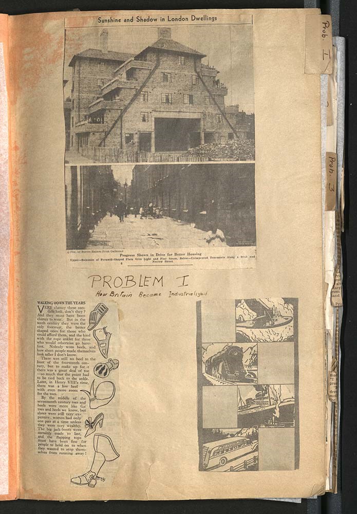
British, Canadian and global development scrapbook
https://archives.whyte.org/en/permalink/descriptions22394
- Part Of
- Luxton family fonds
- Scope & Content
- Scrapbook is organized into sections marked with tabs labeled: Prob. 1, 2, 3, IV, 5, VI, 6, and 7. Scrapbook consists of newspaper clippings relating to: The industrialization of Britain Britain at war The war The Royals The Middle East The Industrial Revolution Russian and Japanese war effort Pri…
- Date Range
- [1936 - 1939]
- Reference Code
- LUX / III / B4 - 10
- Description Level
- 5 / File
- GMD
- Textual record
- Scrapbook
1 image
1 Electronic Resource
- Part Of
- Luxton family fonds
- Description Level
- 5 / File
- Fonds Number
- LUX
- Series
- III.B.4. Georgina Luxton : Collected Material : Textual Records
- Sous-Fonds
- III. Luxton Family sous-fonds
- Accession Number
- LUX
- Reference Code
- LUX / III / B4 - 10
- Date Range
- [1936 - 1939]
- Physical Description
- 2 cm of textual records
- Scope & Content
- Scrapbook is organized into sections marked with tabs labeled: Prob. 1, 2, 3, IV, 5, VI, 6, and 7. Scrapbook consists of newspaper clippings relating to: The industrialization of Britain Britain at war The war The Royals The Middle East The Industrial Revolution Russian and Japanese war effort Princesses Elizabeth, Margaret, and Prince Edward, and other Royal children Article: "Britain's Prize Colony" - Canada World events Wheat production in Argentina
- Name Access
- Luxton, Eleanor
- Churchill, Winston
- Subject Access
- Airplanes
- Events
- Government
- History
- Industry
- Laws and legislation
- Military
- Newspaper
- Politics
- Public events
- Royal tours
- War
- World War II
- Geographic Access
- Canada
- Alberta
- Calgary
- England
- London
- Language
- English
- Conservation
- Pages have been interleaved
- Category
- Commerce and industry
- Government
- Military
- Politics
- Title Source
- Title based on contents of scrapbook
- Processing Status
- Processed
Electronic Resources
Images
This material is presented as originally created; it may contain outdated cultural descriptions and
potentially offensive content.
Read more.
Jasper Trails Project - map publishers
https://archives.whyte.org/en/permalink/descriptions56241
- Part Of
- Ben Gadd fonds
- Scope & Content
- File consists of correspondence sent between Ben Gadd and various map publishing companies, and samples of previously published maps and travel guides. Correspondence pertains to the production of trail maps which were designed by the Friends of Jasper National Park and Parks Canada as part of the …
- Date Range
- 1994
- 1996-1997
- Reference Code
- M590 / III / D / 114
- Description Level
- 5 / File
- GMD
- Textual record
- Published record
- Map
- Part Of
- Ben Gadd fonds
- Description Level
- 5 / File
- Fonds Number
- M590
- V810
- S61
- Series
- M590 / III : Published records
- Sous-Fonds
- M590
- Sub-Series
- M590 / III / D : Other contracts and projects
- Accession Number
- 2021.20
- Reference Code
- M590 / III / D / 114
- Date Range
- 1994
- 1996-1997
- Physical Description
- 0.5 cm of textual records
- Scope & Content
- File consists of correspondence sent between Ben Gadd and various map publishing companies, and samples of previously published maps and travel guides. Correspondence pertains to the production of trail maps which were designed by the Friends of Jasper National Park and Parks Canada as part of the Jasper Trails Project.
- Name Access
- Gadd, Ben
- Subject Access
- Organization
- Trails
- Map
- Environment
- Geography
- Parks Canada
- Government
- Tourist information
- Publication
- Businesses
- Geographic Access
- Canada
- Alberta
- Jasper
- Jasper National Park
- Reproduction Restrictions
- Restrictions may apply
- Language
- English
- Category
- Environment
- Government
- Title Source
- Title based on contents of file
- Processing Status
- Processed
This material is presented as originally created; it may contain outdated cultural descriptions and
potentially offensive content.
Read more.
Jasper Trails Project - printed trail maps
https://archives.whyte.org/en/permalink/descriptions56152
- Part Of
- Ben Gadd fonds
- Scope & Content
- File consists of printed drafts of trail maps depicting regions near Pyramid Bench, Maligne Canyon, Wabasso Lake and Miette River; and quotes from three printing companies in Alberta. Materials pertain to the updating of trail signage and interpretive information through the Jasper Trails Project.
- Date Range
- 1997-1998
- Reference Code
- M590 / III / D / 106
- Description Level
- 5 / File
- GMD
- Textual record
- Map
- Part Of
- Ben Gadd fonds
- Description Level
- 5 / File
- Fonds Number
- M590
- V810
- S61
- Series
- M590 / III : Published records
- Sous-Fonds
- M590
- Sub-Series
- M590 / III / D : Other contracts and projects
- Accession Number
- 2021.20
- Reference Code
- M590 / III / D / 106
- GMD
- Textual record
- Map
- Date Range
- 1997-1998
- Physical Description
- 0.2 cm of textual records
- Scope & Content
- File consists of printed drafts of trail maps depicting regions near Pyramid Bench, Maligne Canyon, Wabasso Lake and Miette River; and quotes from three printing companies in Alberta. Materials pertain to the updating of trail signage and interpretive information through the Jasper Trails Project.
- Subject Access
- Organization
- Trails
- Research
- Map
- Environment
- Hiking
- Recreation
- Geography
- Parks Canada
- Government
- Geographic Access
- Canada
- Alberta
- Jasper
- Jasper National Park
- Edmonton
- Reproduction Restrictions
- Restrictions may apply
- Language
- English
- Title Source
- Title based on contents of file
- Processing Status
- Processed
This material is presented as originally created; it may contain outdated cultural descriptions and
potentially offensive content.
Read more.
Jasper Trails Project - sign location maps
https://archives.whyte.org/en/permalink/descriptions56154
- Part Of
- Ben Gadd fonds
- Scope & Content
- File consists of maps showing the locations of interpretive signs which were updated and installed as part of the Jasper Trails Project. File includes film positive copies of maps, and related notes and correspondence.
- Date Range
- 1995
- 1997
- Reference Code
- M590 / III / D / 107
- Description Level
- 5 / File
- GMD
- Textual record
- Map
- Part Of
- Ben Gadd fonds
- Description Level
- 5 / File
- Fonds Number
- M590
- V810
- S61
- Series
- M590 / III : Published records
- Sous-Fonds
- M590
- Sub-Series
- M590 / III / D : Other contracts and projects
- Accession Number
- 2021.20
- Reference Code
- M590 / III / D / 107
- GMD
- Textual record
- Map
- Date Range
- 1995
- 1997
- Physical Description
- 1 cm of textual records
- Scope & Content
- File consists of maps showing the locations of interpretive signs which were updated and installed as part of the Jasper Trails Project. File includes film positive copies of maps, and related notes and correspondence.
- Subject Access
- Organization
- Trails
- Research
- Map
- Environment
- Hiking
- Recreation
- Geography
- Parks Canada
- Government
- Geographic Access
- Canada
- Alberta
- Jasper
- Jasper National Park
- Reproduction Restrictions
- Restrictions may apply
- Language
- English
- Title Source
- Title based on contents of file
- Processing Status
- Processed
This material is presented as originally created; it may contain outdated cultural descriptions and
potentially offensive content.
Read more.
Maligne Lake fact sheet
https://archives.whyte.org/en/permalink/descriptions56072
- Part Of
- Ben Gadd fonds
- Scope & Content
- File consists of documents pertaining to a fact sheet about Maligne Lake which Ben Gadd produced for Parks Canada while working as a Seasonal Naturalist in Jasper. File includes cropped sections of a map depicting Maligne Lake and surrounding areas; research and planning notes written by Ben; a pro…
- Date Range
- [ca.1980-1984]
- Reference Code
- M590 / III / A / 9
- Description Level
- 5 / File
- GMD
- Textual record
- Map
- Part Of
- Ben Gadd fonds
- Description Level
- 5 / File
- Fonds Number
- M590
- V810
- S61
- Series
- M590 / III : Professional records
- Sous-Fonds
- M590
- Sub-Series
- M590 / III / A : Parks Canada records
- Accession Number
- 2021.20
- Reference Code
- M590 / III / A / 9
- GMD
- Textual record
- Map
- Responsibility
- Produced by Ben Gadd
- Date Range
- [ca.1980-1984]
- Physical Description
- 0.2 cm of textual records
- Scope & Content
- File consists of documents pertaining to a fact sheet about Maligne Lake which Ben Gadd produced for Parks Canada while working as a Seasonal Naturalist in Jasper. File includes cropped sections of a map depicting Maligne Lake and surrounding areas; research and planning notes written by Ben; a prospectus/summary of the project; and a scanned paper copy of film strips depicting images of Maligne Lake.
- Name Access
- Gadd, Ben
- Subject Access
- Parks Canada
- Government
- Environment
- Landscape
- Geography
- Geological formation
- Geology
- Natural history
- Geographic Access
- Canada
- Alberta
- Maligne Lake
- Jasper National Park
- Reproduction Restrictions
- Restrictions may apply
- Language
- English
- Category
- Environment
- Government
- Title Source
- Title based on contents of file
- Processing Status
- Processed
This material is presented as originally created; it may contain outdated cultural descriptions and
potentially offensive content.
Read more.
Maligne Lake tear-off map
https://archives.whyte.org/en/permalink/descriptions56073
- Part Of
- Ben Gadd fonds
- Scope & Content
- File consists of documents pertaining to the creation of a tear-off map of Maligne Lake, which Ben Gadd produced for Parks Canada while working as a Seasonal Naturalist in Jasper. File includes a project proposal, textual drafts, visual layout samples, correspondence, invoices and other related mat…
- Date Range
- [ca.1980-1984]
- Reference Code
- M590 / III / A / 10
- Description Level
- 5 / File
- GMD
- Textual record
- Map
- Part Of
- Ben Gadd fonds
- Description Level
- 5 / File
- Fonds Number
- M590
- V810
- S61
- Series
- M590 / III : Professional records
- Sous-Fonds
- M590
- Sub-Series
- M590 / III / A : Parks Canada records
- Accession Number
- 2021.20
- Reference Code
- M590 / III / A / 10
- GMD
- Textual record
- Map
- Responsibility
- Produced by Ben Gadd
- Date Range
- [ca.1980-1984]
- Physical Description
- 1 cm of textual records
- Scope & Content
- File consists of documents pertaining to the creation of a tear-off map of Maligne Lake, which Ben Gadd produced for Parks Canada while working as a Seasonal Naturalist in Jasper. File includes a project proposal, textual drafts, visual layout samples, correspondence, invoices and other related materials.
- Name Access
- Gadd, Ben
- Subject Access
- Parks Canada
- Government
- Environment
- Geography
- Geology
- Natural history
- Map
- Geographic Access
- Canada
- Alberta
- Maligne Lake
- Jasper National Park
- Reproduction Restrictions
- Restrictions may apply
- Language
- English
- Category
- Environment
- Government
- Title Source
- Title based on contents of file
- Processing Status
- Processed
This material is presented as originally created; it may contain outdated cultural descriptions and
potentially offensive content.
Read more.
Maps of Banff and Western Canada
https://archives.whyte.org/en/permalink/descriptions54772
- Part Of
- Luxton family fonds
- Scope & Content
- File consists of 9 printed maps, b&w and col. [including zoning and topographical maps] depicting the Town of Banff and Banff National Park, the Rocky Mountains Forest Reserve, the Moose Mountain region, Medicine Hat, and the province of Alberta. File includes Trail Riders' Map of the Canadian Rock…
- Date Range
- 1912
- 1914
- 1924
- 1926
- 1932
- 1957
- [1970-1980]
- Reference Code
- LUX / II / C5 / 25
- Description Level
- 5 / File
- GMD
- Textual record
- Published record
- Map
- Part Of
- Luxton family fonds
- Description Level
- 5 / File
- Fonds Number
- LUX
- Series
- LUX / II / C : Personal
- Sous-Fonds
- LUX / II : Eleanor Luxton sous-fonds
- Sub-Series
- LUX / II / C5 : Other
- Accession Number
- LUX
- Reference Code
- LUX / II / C5 / 25
- Date Range
- 1912
- 1914
- 1924
- 1926
- 1932
- 1957
- [1970-1980]
- Physical Description
- 9 maps : b&w and col. ; 168 x 71 cm or smaller
- Scope & Content
- File consists of 9 printed maps, b&w and col. [including zoning and topographical maps] depicting the Town of Banff and Banff National Park, the Rocky Mountains Forest Reserve, the Moose Mountain region, Medicine Hat, and the province of Alberta. File includes Trail Riders' Map of the Canadian Rockies which has smaller maps of Waterton Lakes, Glacier, Revelstoke, and other national parks printed on the back. Map of Medicine Hat includes annotated storage envelope with dimensions written on the front.
- Subject Access
- Cartography
- Geography
- Land use
- Government
- Travel
- National parks and reserves
- Geographic Access
- Canada
- Alberta
- Banff
- Banff National Park
- Medicine Hat
- Rocky Mountains
- Glacier National Park
- Revelstoke
- Waterton Lakes National Park
- Reproduction Restrictions
- Restrictions may apply
- Language
- English
- Title Source
- Title based on contents of file
- Processing Status
- Processed
This material is presented as originally created; it may contain outdated cultural descriptions and
potentially offensive content.
Read more.