Narrow Results By
- 1970s 2717
- 1960s 1703
- 1980s 1691
- 1990s
- 1950s 946
- 2000s 848
- 2010s 708
- 1920s 659
- 1930s 634
- 1910s 603
- 1940s 587
- 1900s 405
- 1890s
- 1880s 164
- 2020s 164
- 1870s 115
- 1860s 84
- 1850s 64
- 1840s 39
- 1820s 26
- 1830s 26
- 1780s 24
- 1800s 14
- 1810s 13
- 1770s 6
- 1790s 6
- 1570s 2
- 1740s 2
- 1560s 1
- 1610s 1
- 1680s 1
- 1700s 1
- 1710s 1
- 1720s 1
- 1750s 1
- 1760s 1
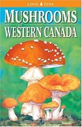
Mushrooms of Western Canada
https://archives.whyte.org/en/permalink/catalogue26228
- Medium
- Library - Book (including soft-cover and pamphlets)
- Published Date
- 1991
- 2021
- Author
- Schalkwijk-Barendsen, Helen M.E.
- Publisher
- Edmonton, AB : Lone Pine Publishing
- Call Number
- 04.1 Sch1m 1991
- 04.1 Sch1m 2021
- Publisher
- Edmonton, AB : Lone Pine Publishing
- Published Date
- 1991
- 2021
- Physical Description
- 416 pages : illustrations ; 20 cm
- Contents
- Introduction -- Illustrated key to fruiting bodies -- Classification overview -- Keys to colour illustrations -- Colour illustrations -- Species descriptions.
- Notes
- Ben Gadd Personal Library
- ISBN
- 0919433472
- Accession Number
- 2021.20
- Call Number
- 04.1 Sch1m 1991
- 04.1 Sch1m 2021
- Collection
- Archives Library
This material is presented as originally created; it may contain outdated cultural descriptions and
potentially offensive content.
Read more.
Mountain climbing
https://archives.whyte.org/en/permalink/catalogue26175
- Medium
- Library - Book (including soft-cover and pamphlets)
- Published Date
- 1897
- Publisher
- London : Charles Scribner's Sons
- Call Number
- 01 W69m
- Responsibility
- Edward L. Wilson, Edwin Lord Weeks, A. F. Jaccaci, W. Martin-Conway, Mark Brickell Kerr, William Williams, and H. F. B. Lynch
- Publisher
- London : Charles Scribner's Sons
- Published Date
- 1897
- Physical Description
- 358 pages
- Subjects
- Mountaineering
- St. Elias
- Alps
- Climbing
- Glaciers
- Contents
- I. Mount Washington in winter / Edward L. Wilson -- II. Some episodes of mountaineering by a cause amateur / Edwin Lord Weeks -- III. Ascent of Mount Aetna / A. F. Jaccaci -- IV. Ascent of Mount Ararat / H. F. B. Lynch -- V. Climbing Mount St. Elias / William Williams -- VI. Mount St. Elias and its glaciers / Mark Brickell Kerr -- VII. One thousand miles through the Alps / Sir. W. Martin Conway
- Accession Number
- 2023.47
- Call Number
- 01 W69m
- Collection
- Archives Library
This material is presented as originally created; it may contain outdated cultural descriptions and
potentially offensive content.
Read more.
My climbs in the Alps and Caucasus
https://archives.whyte.org/en/permalink/catalogue26179
- Medium
- Library - Book (including soft-cover and pamphlets)
- Published Date
- 1895
- Author
- Mummery, A. F.
- Publisher
- London : T. Fisher Unwin
- Call Number
- 01.2 M92m
- Author
- Mummery, A. F.
- Publisher
- London : T. Fisher Unwin
- Published Date
- 1895
- Physical Description
- 360 pages
- Subjects
- Mountaineering
- Alps
- Caucasus
- Mummery, A. F.
- Accession Number
- 2023.47
- Call Number
- 01.2 M92m
- Collection
- Archives Library
This material is presented as originally created; it may contain outdated cultural descriptions and
potentially offensive content.
Read more.
My home in the Alps
https://archives.whyte.org/en/permalink/catalogue26170
- Medium
- Library - Book (including soft-cover and pamphlets)
- Published Date
- 1892
- Author
- Le Blond, Elizabeth
- Publisher
- London : Sampson Low, Marston, and Company Limited
- Call Number
- 02.2 L46m
- Author
- Le Blond, Elizabeth
- Responsibility
- Mrs. Main
- Publisher
- London : Sampson Low, Marston, and Company Limited
- Published Date
- 1892
- Physical Description
- 131 pages
- Accession Number
- 2023.47
- Call Number
- 02.2 L46m
- Collection
- Archives Library
This material is presented as originally created; it may contain outdated cultural descriptions and
potentially offensive content.
Read more.
The alpine regions of Switzerland and the neighbouring countries : a pedestrian's noteson their physical features, scenery, and natural history
https://archives.whyte.org/en/permalink/catalogue26161
- Medium
- Library - Book (including soft-cover and pamphlets)
- Published Date
- 1896
- Author
- Bonney, T. G.
- Publisher
- Cambridge : Deighton, Bell, and Co.
- Edition
- 1st edition
- Call Number
- 02.2 B64a
- Author
- Bonney, T. G.
- Responsibility
- Illustrations by E. Whymper
- Edition
- 1st edition
- Publisher
- Cambridge : Deighton, Bell, and Co.
- Published Date
- 1896
- Physical Description
- 351 pages ; 15 ill. ; 5 plates
- Subjects
- Switzerland
- Geology
- Italy
- Glaciers
- Animals
- Avalanches
- Botany
- Folklore
- Accession Number
- 2023.47
- Call Number
- 02.2 B64a
- Collection
- Archives Library
This material is presented as originally created; it may contain outdated cultural descriptions and
potentially offensive content.
Read more.
The Group of Seven : art for a nation
https://archives.whyte.org/en/permalink/catalogue25678
- Medium
- Library - Book (including soft-cover and pamphlets)
- Published Date
- 1995
- Author
- Hill, Charles C.
- Publisher
- Ottawa : National Gallery of Canada ; Toronto, Ont. : McClelland & Stewart
- Call Number
- 06.1 H55t
- Author
- Hill, Charles C.
- Publisher
- Ottawa : National Gallery of Canada ; Toronto, Ont. : McClelland & Stewart
- Published Date
- 1995
- Physical Description
- 374 pages : illustrations (some colour) ; 32 cm
- Subjects
- Group of Seven
- History-Canada
- Artists
- ISBN
- 077106716X
- Accession Number
- 2022.27
- Call Number
- 06.1 H55t
- Collection
- Archives Library
This material is presented as originally created; it may contain outdated cultural descriptions and
potentially offensive content.
Read more.

Topographical maps
https://archives.whyte.org/en/permalink/descriptions56805
- Part Of
- Ben Gadd fonds
- Scope & Content
- Sub-sub series consists of topographical maps depicting various regions in Canada and the United States, which were collected by Ben Gadd. Includes ca.13 maps of regions in the United States (including Eagletail National Park in Arizona, Colorado Springs, and Montana); and ca.213 maps of regions in…
- Date Range
- [ca.1960-2005]
- Reference Code
- M590 / I / A / ii
- Description Level
- 4.1 / Sub-sub-series
- GMD
- Map
- Part Of
- Ben Gadd fonds
- Description Level
- 4.1 / Sub-sub-series
- Fonds Number
- M590
- V810
- S61
- Series
- M590 / I : Personal records
- Sous-Fonds
- M590
- Sub-Series
- M590 / I / A / ii : Travel guides and maps : Topographical maps
- Accession Number
- 2021.20
- Reference Code
- M590 / I / A / ii
- GMD
- Map
- Date Range
- [ca.1960-2005]
- Physical Description
- ca.226 topographical maps
- Scope & Content
- Sub-sub series consists of topographical maps depicting various regions in Canada and the United States, which were collected by Ben Gadd. Includes ca.13 maps of regions in the United States (including Eagletail National Park in Arizona, Colorado Springs, and Montana); and ca.213 maps of regions in Northern Canada, Western Canada and the Canadian Rockies (predominantly Alberta and British Columbia, as well as the Yukon).
- Notes
- Some maps include annotations by Ben Gadd
- Name Access
- Gadd, Ben
- Geographic Access
- Canada
- Alberta
- British Columbia
- Yukon
- Canadian Rocky Mountains
- Rocky Mountains
- Reproduction Restrictions
- Restrictions may apply
- Language
- English
- Category
- Exploration and travel
- Title Source
- Title based on contents of file
- Processing Status
- Processed
This material is presented as originally created; it may contain outdated cultural descriptions and
potentially offensive content.
Read more.
Travel guides and pocket maps
https://archives.whyte.org/en/permalink/descriptions56806
- Part Of
- Ben Gadd fonds
- Scope & Content
- Sub-sub-series consists of ca.30 travel maps and guides collected by Ben Gadd, primarily pertaining to regions in the United States. Includes regions in Colorado, Arizona, British Columbia, Alberta and Saskatchewan.
- Date Range
- [ca.1970-2005]
- Reference Code
- M590 / I / A / i
- Description Level
- 4.1 / Sub-sub-series
- GMD
- Map
- Part Of
- Ben Gadd fonds
- Description Level
- 4.1 / Sub-sub-series
- Fonds Number
- M590
- V810
- S61
- Series
- M590 / I : Personal records
- Sous-Fonds
- M590
- Sub-Series
- M590 / I / A / i : Travel guides and pocket maps
- Accession Number
- 2021.20
- Reference Code
- M590 / I / A / i
- GMD
- Map
- Date Range
- [ca.1970-2005]
- Physical Description
- ca.30 travel guides and maps
- Scope & Content
- Sub-sub-series consists of ca.30 travel maps and guides collected by Ben Gadd, primarily pertaining to regions in the United States. Includes regions in Colorado, Arizona, British Columbia, Alberta and Saskatchewan.
- Name Access
- Gadd, Ben
- Geographic Access
- Canada
- Alberta
- British Columbia
- Saskatchewan
- Canadian Rocky Mountains
- United States of America
- Colorado
- Arizona
- Reproduction Restrictions
- Restrictions may apply
- Language
- English
- Title Source
- Title based on contents of file
- Processing Status
- Processed
This material is presented as originally created; it may contain outdated cultural descriptions and
potentially offensive content.
Read more.
- Part Of
- Ben Gadd fonds
- Scope & Content
- Sub-sub-series consists of ca.50 maps of various regions in Western Canada and Alaska which were collected by Ben Gadd. Maps are arranged according to associated highways which the mapped regions depict.
- Date Range
- [ca.1970-2005]
- Reference Code
- M590 / I / A / iv
- Description Level
- 4.1 / Sub-sub-series
- GMD
- Map
- Part Of
- Ben Gadd fonds
- Description Level
- 4.1 / Sub-sub-series
- Fonds Number
- M590
- V810
- S61
- Series
- M590 / I : Personal records
- Sous-Fonds
- M590
- Sub-Series
- M590 / I / A / iv : Travel guides and maps : Highway maps
- Accession Number
- 2021.20
- Reference Code
- M590 / I / A / iv
- GMD
- Map
- Date Range
- [ca.1970-2005]
- Physical Description
- ca.50 maps -- 4 paper scans of maps
- Scope & Content
- Sub-sub-series consists of ca.50 maps of various regions in Western Canada and Alaska which were collected by Ben Gadd. Maps are arranged according to associated highways which the mapped regions depict.
- Notes
- Regions included in file: Highway 3 Highway 6 Highway 11 Highway 16 Highway 22 & 40 Highway 93 [To Jasper] Highway 93 [To Radium] Highway 97 [Pine Pass] Highway 97 [Alaska Highway]
- Name Access
- Gadd, Ben
- Geographic Access
- Canada
- Alberta
- British Columbia
- Canadian Rocky Mountains
- Alaska
- Reproduction Restrictions
- Restrictions may apply
- Language
- English
- Title Source
- Title based on contents of file
- Processing Status
- Processed
This material is presented as originally created; it may contain outdated cultural descriptions and
potentially offensive content.
Read more.
Travel guides and maps
https://archives.whyte.org/en/permalink/descriptions56361
- Part Of
- Ben Gadd fonds
- Scope & Content
- Sub-series consists of travel brochures and maps which were collected and used by Ben Gadd. Sub-series contains five sub-sub series: M590 / I / A / i : Travel guides and pocket maps M590 / I / A / ii : Topographical maps M590 / I / A / iii : Geological maps M590 / I / A / iv : Highway maps M590 / …
- Date Range
- [ca.1920-2010]
- Reference Code
- M590 / I / A
- Description Level
- 4 / Sub-series
- GMD
- Map
- Textual record
- Part Of
- Ben Gadd fonds
- Description Level
- 4 / Sub-series
- Fonds Number
- M590
- V810
- S61
- Series
- M590 / I : Personal records
- Sous-Fonds
- M590
- Sub-Series
- M590 / I / A : Travel guides and maps
- Accession Number
- 2021.20
- Reference Code
- M590 / I / A
- GMD
- Map
- Textual record
- Date Range
- [ca.1920-2010]
- Physical Description
- ca. 274 maps -- ca. 61 travel guides, brochures
- Scope & Content
- Sub-series consists of travel brochures and maps which were collected and used by Ben Gadd. Sub-series contains five sub-sub series: M590 / I / A / i : Travel guides and pocket maps M590 / I / A / ii : Topographical maps M590 / I / A / iii : Geological maps M590 / I / A / iv : Highway maps M590 / I / A / v : Index maps, other
- Notes
- Some materials in sub-series are annotated with notes by Ben Gadd
- Name Access
- Gadd, Ben
- Subject Access
- Geography
- Geology
- Environment
- Map
- Tourism
- Tourist information
- Travel
- Trails
- Roads
- Transportation
- Natural history
- National parks and reserves
- Provincial parks and reserves
- Government
- Sports
- Recreation
- Hiking
- Geographic Access
- Canada
- Alberta
- British Columbia
- Banff National Park
- Jasper National Park
- Kootenay National Park
- Yoho National Park
- Waterton Lakes National Park
- Columbia Icefields
- United States of America
- Colorado
- Montana
- Yellowstone National Park
- Access Restrictions
- Restrictions may apply - some materials are fragile
- Reproduction Restrictions
- Restrictions may apply
- Language
- English
- Conservation
- Some fragile/torn materials stored in mylar
- Category
- Environment
- Exploration, discovery and travel
- Government
- Sports, recreation and leisure
- Transportation
- Tourism
- Title Source
- Title based on contents of sub-series
- Processing Status
- Processed
This material is presented as originally created; it may contain outdated cultural descriptions and
potentially offensive content.
Read more.
Operation Bow-Athabasca exhibit
https://archives.whyte.org/en/permalink/descriptions56253
- Part Of
- Ben Gadd fonds
- Scope & Content
- File consists of correspondence, maps and other documents pertaining to the Operation Bow-Athabasca exhibit, which was displayed at the Canmore Museum and Geoscience Centre in 2012. File includes a programme for the opening of the exhibition; geological maps and other research materials; a quote fo…
- Date Range
- 1973
- 2010-2012
- Reference Code
- M590 / III / D / 117
- Description Level
- 5 / File
- GMD
- Textual record
- Published record
- Map
- Part Of
- Ben Gadd fonds
- Description Level
- 5 / File
- Fonds Number
- M590
- V810
- S61
- Series
- M590 / III : Professional records
- Sous-Fonds
- M590
- Sub-Series
- M590 / III / D : Other contracts and projects
- Accession Number
- 2021.20
- Reference Code
- M590 / III / D / 117
- Date Range
- 1973
- 2010-2012
- Physical Description
- 1.5 cm of textual records -- 4 maps
- Scope & Content
- File consists of correspondence, maps and other documents pertaining to the Operation Bow-Athabasca exhibit, which was displayed at the Canmore Museum and Geoscience Centre in 2012. File includes a programme for the opening of the exhibition; geological maps and other research materials; a quote for the production of display signs for the exhibit; Ben Gadd's personal notes pertaining to the exhibit; and other related materials.
- Name Access
- Gadd, Ben
- Subject Access
- Natural history
- Geology
- Environment
- Research
- Public events
- Community events
- Publication
- Museums
- Geographic Access
- Canada
- Alberta
- Canmore
- Reproduction Restrictions
- Restrictions may apply
- Language
- English
- Category
- Environment
- Title Source
- Title based on contents of file
- Processing Status
- Processed
This material is presented as originally created; it may contain outdated cultural descriptions and
potentially offensive content.
Read more.
Jasper Trails Project - map publishers
https://archives.whyte.org/en/permalink/descriptions56241
- Part Of
- Ben Gadd fonds
- Scope & Content
- File consists of correspondence sent between Ben Gadd and various map publishing companies, and samples of previously published maps and travel guides. Correspondence pertains to the production of trail maps which were designed by the Friends of Jasper National Park and Parks Canada as part of the …
- Date Range
- 1994
- 1996-1997
- Reference Code
- M590 / III / D / 114
- Description Level
- 5 / File
- GMD
- Textual record
- Published record
- Map
- Part Of
- Ben Gadd fonds
- Description Level
- 5 / File
- Fonds Number
- M590
- V810
- S61
- Series
- M590 / III : Published records
- Sous-Fonds
- M590
- Sub-Series
- M590 / III / D : Other contracts and projects
- Accession Number
- 2021.20
- Reference Code
- M590 / III / D / 114
- Date Range
- 1994
- 1996-1997
- Physical Description
- 0.5 cm of textual records
- Scope & Content
- File consists of correspondence sent between Ben Gadd and various map publishing companies, and samples of previously published maps and travel guides. Correspondence pertains to the production of trail maps which were designed by the Friends of Jasper National Park and Parks Canada as part of the Jasper Trails Project.
- Name Access
- Gadd, Ben
- Subject Access
- Organization
- Trails
- Map
- Environment
- Geography
- Parks Canada
- Government
- Tourist information
- Publication
- Businesses
- Geographic Access
- Canada
- Alberta
- Jasper
- Jasper National Park
- Reproduction Restrictions
- Restrictions may apply
- Language
- English
- Category
- Environment
- Government
- Title Source
- Title based on contents of file
- Processing Status
- Processed
This material is presented as originally created; it may contain outdated cultural descriptions and
potentially offensive content.
Read more.
Jasper Trails Project - printed trail maps
https://archives.whyte.org/en/permalink/descriptions56152
- Part Of
- Ben Gadd fonds
- Scope & Content
- File consists of printed drafts of trail maps depicting regions near Pyramid Bench, Maligne Canyon, Wabasso Lake and Miette River; and quotes from three printing companies in Alberta. Materials pertain to the updating of trail signage and interpretive information through the Jasper Trails Project.
- Date Range
- 1997-1998
- Reference Code
- M590 / III / D / 106
- Description Level
- 5 / File
- GMD
- Textual record
- Map
- Part Of
- Ben Gadd fonds
- Description Level
- 5 / File
- Fonds Number
- M590
- V810
- S61
- Series
- M590 / III : Published records
- Sous-Fonds
- M590
- Sub-Series
- M590 / III / D : Other contracts and projects
- Accession Number
- 2021.20
- Reference Code
- M590 / III / D / 106
- GMD
- Textual record
- Map
- Date Range
- 1997-1998
- Physical Description
- 0.2 cm of textual records
- Scope & Content
- File consists of printed drafts of trail maps depicting regions near Pyramid Bench, Maligne Canyon, Wabasso Lake and Miette River; and quotes from three printing companies in Alberta. Materials pertain to the updating of trail signage and interpretive information through the Jasper Trails Project.
- Subject Access
- Organization
- Trails
- Research
- Map
- Environment
- Hiking
- Recreation
- Geography
- Parks Canada
- Government
- Geographic Access
- Canada
- Alberta
- Jasper
- Jasper National Park
- Edmonton
- Reproduction Restrictions
- Restrictions may apply
- Language
- English
- Title Source
- Title based on contents of file
- Processing Status
- Processed
This material is presented as originally created; it may contain outdated cultural descriptions and
potentially offensive content.
Read more.
Jasper Trails Project - sign location maps
https://archives.whyte.org/en/permalink/descriptions56154
- Part Of
- Ben Gadd fonds
- Scope & Content
- File consists of maps showing the locations of interpretive signs which were updated and installed as part of the Jasper Trails Project. File includes film positive copies of maps, and related notes and correspondence.
- Date Range
- 1995
- 1997
- Reference Code
- M590 / III / D / 107
- Description Level
- 5 / File
- GMD
- Textual record
- Map
- Part Of
- Ben Gadd fonds
- Description Level
- 5 / File
- Fonds Number
- M590
- V810
- S61
- Series
- M590 / III : Published records
- Sous-Fonds
- M590
- Sub-Series
- M590 / III / D : Other contracts and projects
- Accession Number
- 2021.20
- Reference Code
- M590 / III / D / 107
- GMD
- Textual record
- Map
- Date Range
- 1995
- 1997
- Physical Description
- 1 cm of textual records
- Scope & Content
- File consists of maps showing the locations of interpretive signs which were updated and installed as part of the Jasper Trails Project. File includes film positive copies of maps, and related notes and correspondence.
- Subject Access
- Organization
- Trails
- Research
- Map
- Environment
- Hiking
- Recreation
- Geography
- Parks Canada
- Government
- Geographic Access
- Canada
- Alberta
- Jasper
- Jasper National Park
- Reproduction Restrictions
- Restrictions may apply
- Language
- English
- Title Source
- Title based on contents of file
- Processing Status
- Processed
This material is presented as originally created; it may contain outdated cultural descriptions and
potentially offensive content.
Read more.
Travel guides - United States, Italy
https://archives.whyte.org/en/permalink/descriptions55928
- Part Of
- Ben Gadd fonds
- Scope & Content
- File consists of travel guides collected by Ben Gadd pertaining to Olympic National Park and other destinations in the United States and Italy.
- Date Range
- [ca.1990-2010]
- Reference Code
- M590 / I / A / i / 14
- Description Level
- 5 / File
- GMD
- Published record
- Textual record
- Map
- Part Of
- Ben Gadd fonds
- Description Level
- 5 / File
- Fonds Number
- M590
- V810
- S61
- Series
- M590 / I : Personal records
- Sous-Fonds
- M590
- Sub-Series
- M590 / I / A : Travel guides and maps
- Accession Number
- 2021.20
- Reference Code
- M590 / I / A / i / 14
- Date Range
- [ca.1990-2010]
- Physical Description
- 2 cm of textual records
- Scope & Content
- File consists of travel guides collected by Ben Gadd pertaining to Olympic National Park and other destinations in the United States and Italy.
- Subject Access
- Geography
- Travel
- Tourism
- Tourist information
- National parks and reserves
- Geographic Access
- United States of America
- Washington
- Hawaii
- Italy
- Reproduction Restrictions
- Copyright restrictions may apply
- Language
- English
- Category
- Exploration, discovery and travel
- Title Source
- Title based on contents of file
- Processing Status
- Processed
This material is presented as originally created; it may contain outdated cultural descriptions and
potentially offensive content.
Read more.
Travel guides - Canmore, Kananaskis
https://archives.whyte.org/en/permalink/descriptions55910
- Part Of
- Ben Gadd fonds
- Scope & Content
- File consists of travel guides collected by Ben Gadd pertaining to areas near Canmore and Kananaskis.
- Date Range
- 1998
- 2006
- Reference Code
- M590 / I / A / i / 1 to 2
- Description Level
- 5 / File
- GMD
- Published record
- Textual record
- Map
- Part Of
- Ben Gadd fonds
- Description Level
- 5 / File
- Fonds Number
- M590
- V810
- S61
- Series
- M590 / I : Personal records
- Sous-Fonds
- M590
- Sub-Series
- M590 / I / A : Travel guides and maps
- Accession Number
- 2021.20
- Reference Code
- M590 / I / A / i / 1 to 2
- Date Range
- 1998
- 2006
- Physical Description
- 4 cm of textual records
- Scope & Content
- File consists of travel guides collected by Ben Gadd pertaining to areas near Canmore and Kananaskis.
- Subject Access
- Geography
- Travel
- Tourism
- Tourist information
- Geographic Access
- Canada
- Alberta
- Canmore
- Kananaskis
- Reproduction Restrictions
- Copyright restrictions may apply
- Language
- English
- Category
- Exploration, discovery and travel
- Title Source
- Title based on contents of file
- Processing Status
- Processed
This material is presented as originally created; it may contain outdated cultural descriptions and
potentially offensive content.
Read more.
Travel guides - Lake Louise, Yoho
https://archives.whyte.org/en/permalink/descriptions55913
- Part Of
- Ben Gadd fonds
- Scope & Content
- File consists of travel guides collected by Ben Gadd pertaining to areas near Lake Louise and Yoho National Park.
- Date Range
- 1998
- 2001
- Reference Code
- M590 / I / A / i / 3
- Description Level
- 5 / File
- GMD
- Published record
- Textual record
- Map
- Part Of
- Ben Gadd fonds
- Description Level
- 5 / File
- Fonds Number
- M590
- V810
- S61
- Series
- M590 / I : Personal records
- Sous-Fonds
- M590
- Sub-Series
- M590 / I / A : Travel guides and maps
- Accession Number
- 2021.20
- Reference Code
- M590 / I / A / i / 3
- Date Range
- 1998
- 2001
- Physical Description
- 2 cm of textual records
- Scope & Content
- File consists of travel guides collected by Ben Gadd pertaining to areas near Lake Louise and Yoho National Park.
- Subject Access
- Geography
- Travel
- Tourism
- Tourist information
- Geographic Access
- Canada
- Alberta
- British Columbia
- Lake Louise
- Yoho National Park
- Reproduction Restrictions
- Copyright restrictions may apply
- Language
- English
- Category
- Exploration, discovery and travel
- Title Source
- Title based on contents of file
- Processing Status
- Processed
This material is presented as originally created; it may contain outdated cultural descriptions and
potentially offensive content.
Read more.
Travel guides - Icefields
https://archives.whyte.org/en/permalink/descriptions55917
- Part Of
- Ben Gadd fonds
- Scope & Content
- File consists of travel guides collected by Ben Gadd pertaining to Columbia Icefield, Icefields Parkway and the Wapta Icefields.
- Date Range
- 1994
- [ca.2000]
- Reference Code
- M590 / I / A / i / 7
- Description Level
- 5 / File
- GMD
- Published record
- Textual record
- Map
- Part Of
- Ben Gadd fonds
- Description Level
- 5 / File
- Fonds Number
- M590
- V810
- S61
- Series
- M590 / I : Personal records
- Sous-Fonds
- M590
- Sub-Series
- M590 / I / A : Travel guides and maps
- Accession Number
- 2021.20
- Reference Code
- M590 / I / A / i / 7
- Date Range
- 1994
- [ca.2000]
- Physical Description
- 1 cm of textual records
- Scope & Content
- File consists of travel guides collected by Ben Gadd pertaining to Columbia Icefield, Icefields Parkway and the Wapta Icefields.
- Notes
- Travel guide of Wapta Icefields includes annotations on cover by Ben Gadd.
- Subject Access
- Geography
- Travel
- Tourism
- Tourist information
- Geographic Access
- Canada
- Alberta
- Jasper National Park
- Columbia Icefield
- Icefields Parkway
- British Columbia
- Wapta Icefields
- Reproduction Restrictions
- Copyright restrictions may apply
- Language
- English
- Category
- Exploration, discovery and travel
- Title Source
- Title based on contents of file
- Processing Status
- Processed
This material is presented as originally created; it may contain outdated cultural descriptions and
potentially offensive content.
Read more.
Travel guides - Waterton Lakes
https://archives.whyte.org/en/permalink/descriptions55918
- Part Of
- Ben Gadd fonds
- Scope & Content
- File consists of travel guides collected by Ben Gadd pertaining to Waterton Lakes National Park.
- Date Range
- [ca.1995-2000]
- Reference Code
- M590 / I / A / i / 8
- Description Level
- 5 / File
- GMD
- Published record
- Textual record
- Map
- Part Of
- Ben Gadd fonds
- Description Level
- 5 / File
- Fonds Number
- M590
- V810
- S61
- Series
- M590 / I : Personal records
- Sous-Fonds
- M590
- Sub-Series
- M590 / I / A : Travel guides and maps
- Accession Number
- 2021.20
- Reference Code
- M590 / I / A / i / 8
- Date Range
- [ca.1995-2000]
- Physical Description
- 1.5 cm of textual records
- Scope & Content
- File consists of travel guides collected by Ben Gadd pertaining to Waterton Lakes National Park.
- Notes
- One guide includes annotations on cover by Ben Gadd.
- Subject Access
- Geography
- Travel
- Tourism
- Tourist information
- Geographic Access
- Canada
- Alberta
- Waterton
- Waterton Lakes National Park
- Reproduction Restrictions
- Copyright restrictions may apply
- Language
- English
- Category
- Exploration, discovery and travel
- Title Source
- Title based on contents of file
- Processing Status
- Processed
This material is presented as originally created; it may contain outdated cultural descriptions and
potentially offensive content.
Read more.
Travel guides - Calgary, Bragg Creek, Edmonton
https://archives.whyte.org/en/permalink/descriptions55919
- Part Of
- Ben Gadd fonds
- Scope & Content
- File consists of travel guides collected by Ben Gadd pertaining to Calgary, Bragg Creek, Edmonton and surrounding areas.
- Date Range
- 1999
- 2003
- 2004
- Reference Code
- M590 / I / A / i / 9
- Description Level
- 5 / File
- GMD
- Published record
- Textual record
- Map
- Part Of
- Ben Gadd fonds
- Description Level
- 5 / File
- Fonds Number
- M590
- V810
- S61
- Series
- M590 / I : Personal records
- Sous-Fonds
- M590
- Sub-Series
- M590 / I / A : Travel guides and maps
- Accession Number
- 2021.20
- Reference Code
- M590 / I / A / i / 9
- Date Range
- 1999
- 2003
- 2004
- Physical Description
- 2 cm of textual records
- Scope & Content
- File consists of travel guides collected by Ben Gadd pertaining to Calgary, Bragg Creek, Edmonton and surrounding areas.
- Notes
- Some items in file are annotated
- Subject Access
- Geography
- Travel
- Tourism
- Tourist information
- Geographic Access
- Canada
- Alberta
- Calgary
- Bragg Creek
- Edmonton
- Reproduction Restrictions
- Copyright restrictions may apply
- Language
- English
- Category
- Exploration, discovery and travel
- Title Source
- Title based on contents of file
- Processing Status
- Processed
This material is presented as originally created; it may contain outdated cultural descriptions and
potentially offensive content.
Read more.