Narrow Results By
- Nicholas Morant fonds 3
- Luxton family fonds 2
- Arnold Wexler fonds 1
- Arthur Oliver Wheeler fonds 1
- Bert Riggall fonds 1
- Brewster Transport Company Ltd. fonds 1
- Bruno Engler fonds 1
- Burks family fonds 1
- Ernest C. W. Lamarque fonds 1
- Fred Brewster fonds 1
- George K. K. (Tommy) Link fonds 1
- Hermann Hagedorn fonds 1
- Catharine Robb Whyte, O. C. (1906 – 1979, Canadian) 43
- Peter Whyte (1905 – 1966, Canadian) 5
- Schaffer, Mary 2
- Adams, Molly 1
- Alberta/British Columbia Boundary Survey 1
- Brewster Transport Company Ltd. 1
- Brewster, Dell 1
- Brewster, Fern 1
- Brewster, Fred 1
- Brewster, Jack Walker 1
- Brewster, Jim 1
- Brewster, Pat 1
Map showing the northern paortion of Vancouver Island
https://archives.whyte.org/en/permalink/catalogue24531
- Medium
- Library - Maps and blueprints (unannotated; published)
- Map
- Published Date
- 1919
- Publisher
- Dept. of Lands/Honourable T.D. Pattullo. J.E. Umbach Surveyor General
- Call Number
- C10-5.1
- Publisher
- Dept. of Lands/Honourable T.D. Pattullo. J.E. Umbach Surveyor General
- Published Date
- 1919
- Scale
- Scale: 4 miles - 1 inch
- Subjects
- British Columbia
- Vancouver Island
- Accession Number
- 400
- Call Number
- C10-5.1
- Collection
- Archives Library
This material is presented as originally created; it may contain outdated cultural descriptions and
potentially offensive content.
Read more.
Races of Europe
https://archives.whyte.org/en/permalink/catalogue21535
- Medium
- Library - Maps and blueprints (unannotated; published)
- Map
- Published Date
- 1919
- Publisher
- National Geographic Society
- Call Number
- C13-12.5(a)
- Publisher
- National Geographic Society
- Published Date
- 1919
- Subjects
- Europe
- Accession Number
- 400
- Call Number
- C13-12.5(a)
- Collection
- Archives Library
This material is presented as originally created; it may contain outdated cultural descriptions and
potentially offensive content.
Read more.
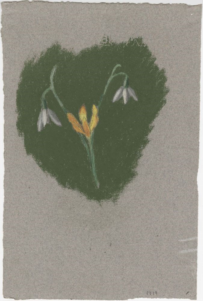
- Date
- 1919
- Medium
- pastel on paper
- Catalogue Number
- WyC.03.246
- Description
- yellow flower in center with two white flowers with green backing
1 image
- Title
- Untitled
- Date
- 1919
- Medium
- pastel on paper
- Dimensions
- 24.0 x 16.0 cm
- Description
- yellow flower in center with two white flowers with green backing
- Subject
- flower
- Credit
- Gift of Catharine Robb Whyte, O. C., Banff, 1979
- Catalogue Number
- WyC.03.246
Images
This material is presented as originally created; it may contain outdated cultural descriptions and
potentially offensive content.
Read more.
[Wildermere, Southern B.C.]
https://archives.whyte.org/en/permalink/catalogue24517
- Medium
- Library - Maps and blueprints (unannotated; published)
- Map
- Published Date
- 1918
- Publisher
- Department of Mines
- Call Number
- C10-2.1
- Publisher
- Department of Mines
- Published Date
- 1918
- Physical Description
- 1 map : col
- Scale
- Scale: 1:125,000
- Relief: Contour interval 200 ft.
- Subjects
- British Columbia
- Windermere
- Notes
- Duplicate = C3-4.1
- Accession Number
- 400
- Call Number
- C10-2.1
- Collection
- Archives Library
This material is presented as originally created; it may contain outdated cultural descriptions and
potentially offensive content.
Read more.
Geological survey [Sooke sheet - Vancouver Island]
https://archives.whyte.org/en/permalink/catalogue24741
- Medium
- Library - Book (including soft-cover and pamphlets)
- Map
- Published Date
- 1918
- Publisher
- Dept. of Mines
- Call Number
- C7-3.10
- Publisher
- Dept. of Mines
- Published Date
- 1918
- Physical Description
- 1 map : col
- Scale
- Scale: 1:125,000
- Relief: Contour interval 100 ft.
- Subjects
- Sooke Sheet - Vancouver Island
- Accession Number
- 400
- Call Number
- C7-3.10
- Collection
- Archives Library
This material is presented as originally created; it may contain outdated cultural descriptions and
potentially offensive content.
Read more.
Geological Survey [Duncan Sheet - Vancouver Island]
https://archives.whyte.org/en/permalink/catalogue24743
- Medium
- Library - Book (including soft-cover and pamphlets)
- Map
- Published Date
- 1918
- Publisher
- Department of Mines
- Call Number
- C7-3.14
- Publisher
- Department of Mines
- Published Date
- 1918
- Physical Description
- 1 map : col
- Scale
- Scale: 1:25,000
- Relief: Contour interval 100 ft.
- Subjects
- Duncan Sheet, Vancouver Island
- Accession Number
- 400
- Call Number
- C7-3.14
- Collection
- Archives Library
This material is presented as originally created; it may contain outdated cultural descriptions and
potentially offensive content.
Read more.
Map of Waterton Lakes National Park, Alberta/from photographic surveys by M.P. Bridgland and A.O. Wheeler
https://archives.whyte.org/en/permalink/catalogue23213
- Medium
- Library - Maps and blueprints (unannotated; published)
- Map
- Published Date
- 1918
- Publisher
- Ottawa: Surveyor General's Office
- Call Number
- C2-6.2e
- Publisher
- Ottawa: Surveyor General's Office
- Published Date
- 1918
- Physical Description
- 1 map : col
- Scale
- Scale: 1:100,00
- Accession Number
- 4008
- Call Number
- C2-6.2e
- Collection
- Archives Library
This material is presented as originally created; it may contain outdated cultural descriptions and
potentially offensive content.
Read more.
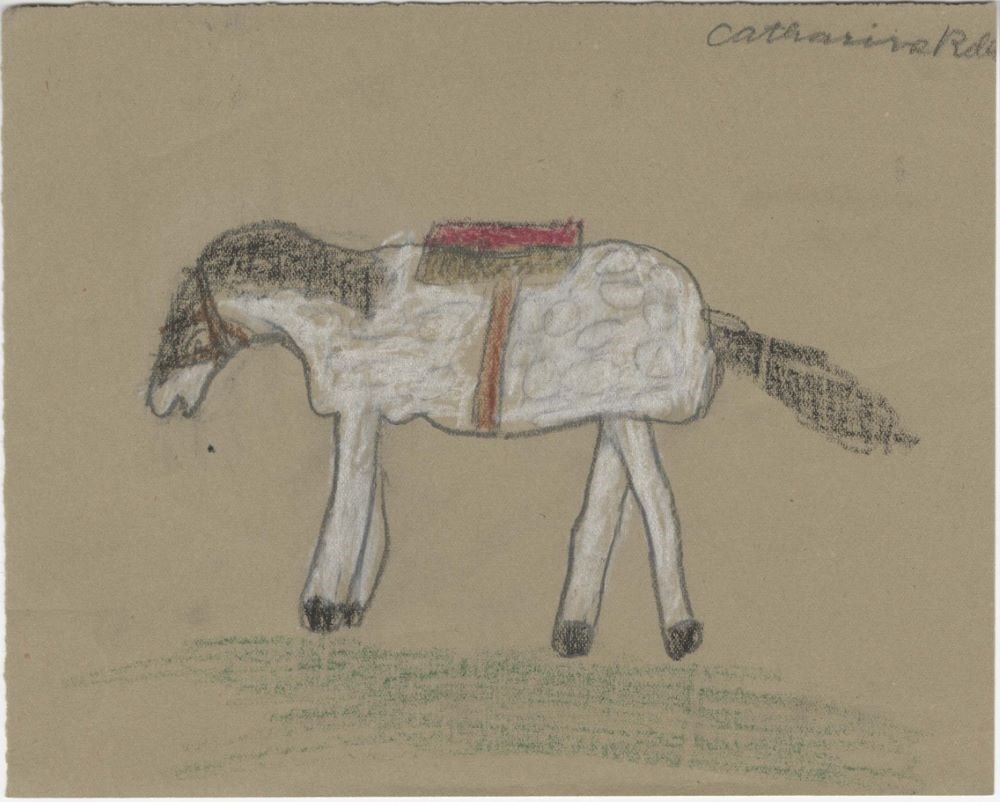
- Date
- 1918
- Medium
- pastel on paper
- Catalogue Number
- WyC.03.129
- Description
- white horse with black hair and red saddleverso: graphite drawing on deer
1 image
- Title
- Untitled
- Date
- 1918
- Medium
- pastel on paper
- Dimensions
- 15.0 x 19.0 cm
- Description
- white horse with black hair and red saddleverso: graphite drawing on deer
- Subject
- horse
- Credit
- Gift of Catharine Robb Whyte, O. C., Banff, 1979
- Catalogue Number
- WyC.03.129
Images
This material is presented as originally created; it may contain outdated cultural descriptions and
potentially offensive content.
Read more.
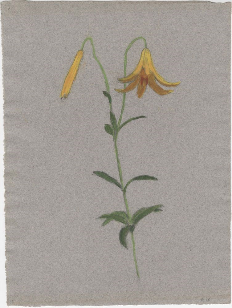
- Date
- 1918
- Medium
- pastel on paper
- Catalogue Number
- WyC.03.227
- Description
- yellow flower
1 image
- Title
- Untitled
- Date
- 1918
- Medium
- pastel on paper
- Dimensions
- 32.5 x 23.5 cm
- Description
- yellow flower
- Subject
- flower
- Credit
- Gift of Catharine Robb Whyte, O. C., Banff, 1979
- Catalogue Number
- WyC.03.227
Images
This material is presented as originally created; it may contain outdated cultural descriptions and
potentially offensive content.
Read more.
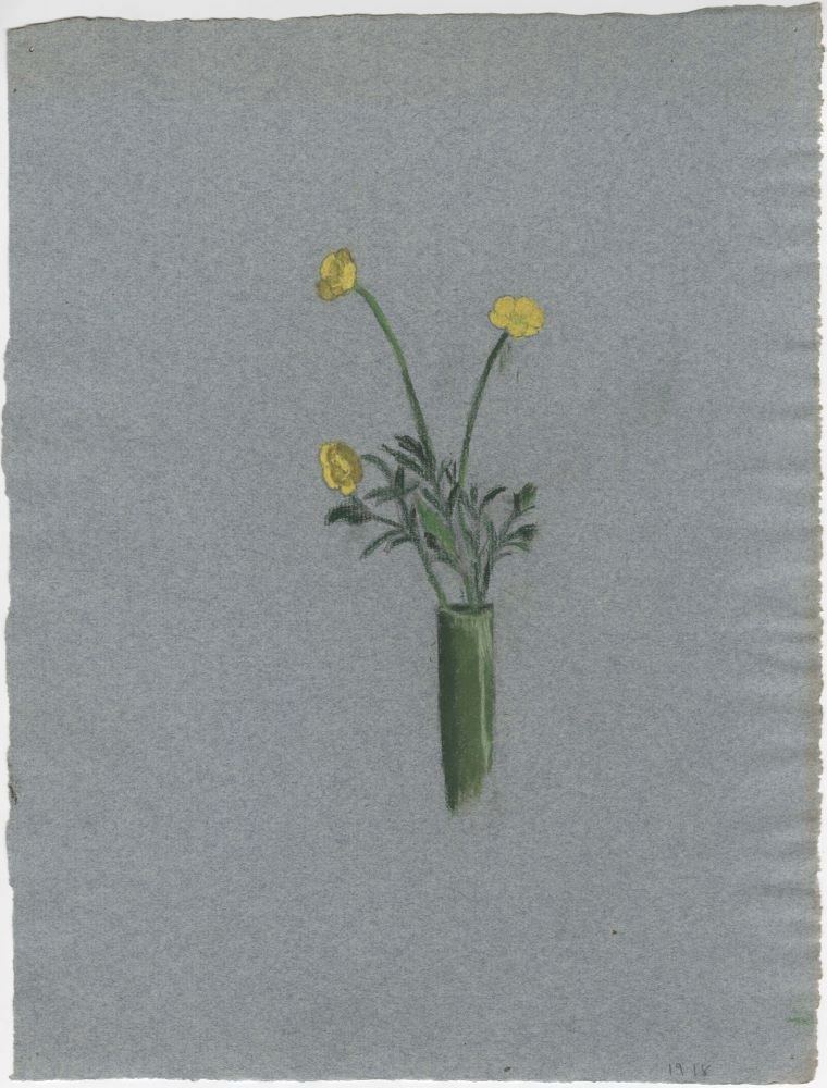
- Date
- 1918
- Medium
- pastel on paper
- Catalogue Number
- WyC.03.228
- Description
- three yellow flowers in green tube vase
1 image
- Title
- Untitled
- Date
- 1918
- Medium
- pastel on paper
- Dimensions
- 31.0 x 24.0 cm
- Description
- three yellow flowers in green tube vase
- Subject
- flower
- Credit
- Gift of Catharine Robb Whyte, O. C., Banff, 1979
- Catalogue Number
- WyC.03.228
Images
This material is presented as originally created; it may contain outdated cultural descriptions and
potentially offensive content.
Read more.
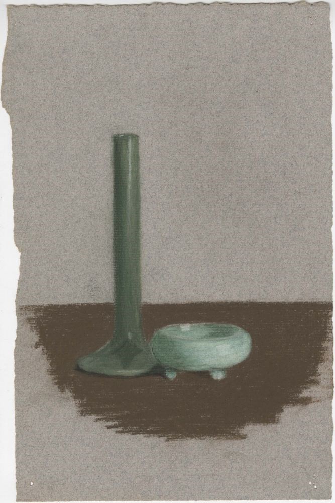
- Date
- 1918
- Medium
- pastel on paper
- Catalogue Number
- WyC.03.285
- Description
- green, tube vase and small, wide, low, green bowl
1 image
- Title
- Untitled
- Date
- 1918
- Medium
- pastel on paper
- Dimensions
- 24.0 x 15.3 cm
- Description
- green, tube vase and small, wide, low, green bowl
- Credit
- Gift of Catharine Robb Whyte, O. C., Banff, 1979
- Catalogue Number
- WyC.03.285
Images
This material is presented as originally created; it may contain outdated cultural descriptions and
potentially offensive content.
Read more.
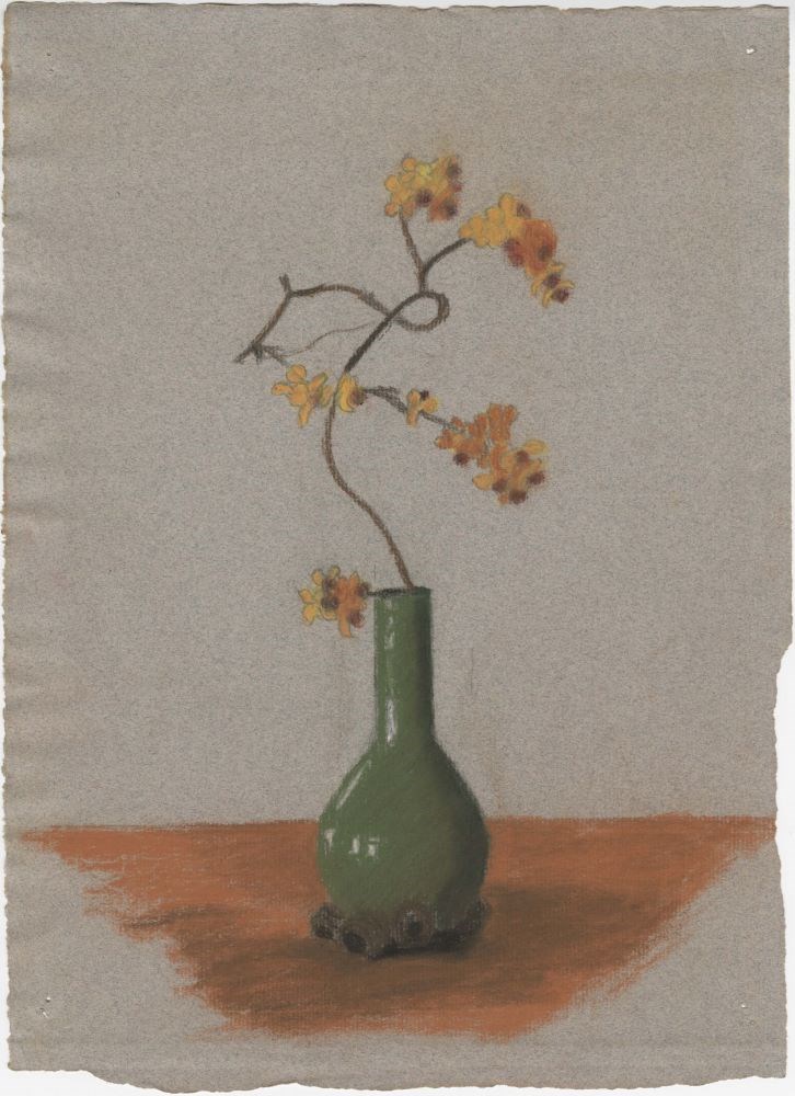
- Date
- 1918
- Medium
- pastel on paper
- Catalogue Number
- WyC.03.288
- Description
- yellow, orange and brown flowers in a green long necked vase
1 image
- Title
- Untitled
- Date
- 1918
- Medium
- pastel on paper
- Dimensions
- 32.0 x 23.5 cm
- Description
- yellow, orange and brown flowers in a green long necked vase
- Subject
- flower
- Credit
- Gift of Catharine Robb Whyte, O. C., Banff, 1979
- Catalogue Number
- WyC.03.288
Images
This material is presented as originally created; it may contain outdated cultural descriptions and
potentially offensive content.
Read more.
Map of central part of Jasper from surveys by M.P. Bridgland
https://archives.whyte.org/en/permalink/catalogue24294
- Medium
- Library - Maps and blueprints (unannotated; published)
- Map
- Published Date
- 1917
- Publisher
- Department of the Interior
- Call Number
- C2-2.1
- Responsibility
- from surveys by M. P. Bridgland
- Publisher
- Department of the Interior
- Published Date
- 1917
- Physical Description
- 6 sheets : col
- Scale
- Scale: 1.014 in. = 1 mile
- Relief: Contour interval: 100 ft.
- Subjects
- Jasper National Park
- Accession Number
- 512
- 718
- Call Number
- C2-2.1
- Collection
- Archives Library
This material is presented as originally created; it may contain outdated cultural descriptions and
potentially offensive content.
Read more.
[Northern Alberta]
https://archives.whyte.org/en/permalink/catalogue24420
- Medium
- Library - Maps and blueprints (unannotated; published)
- Map
- Published Date
- 1917
- Publisher
- Dept. of the Interior
- Call Number
- C9-4.1
- Publisher
- Dept. of the Interior
- Published Date
- 1917
- Physical Description
- 1 map : col
- Scale
- Scale: 12 1/2 miles: 1 inch
- Subjects
- Northern Alberta
- Accession Number
- 478
- Call Number
- C9-4.1
- Collection
- Archives Library
This material is presented as originally created; it may contain outdated cultural descriptions and
potentially offensive content.
Read more.
Map of the Ominecca and Finlay River Basins
https://archives.whyte.org/en/permalink/catalogue24527
- Medium
- Library - Maps and blueprints (unannotated; published)
- Map
- Published Date
- 1917
- Publisher
- Surveyor-General's Office, Victoria, B.C.
- Call Number
- C10-3.5
- Publisher
- Surveyor-General's Office, Victoria, B.C.
- Published Date
- 1917
- Scale
- Scale: 5 miles - 1 inch
- Subjects
- Northern British Columbia
- Accession Number
- 400
- Call Number
- C10-3.5
- Collection
- Archives Library
This material is presented as originally created; it may contain outdated cultural descriptions and
potentially offensive content.
Read more.
[British Columbia Forestry] Map showing forest stand types
https://archives.whyte.org/en/permalink/catalogue24537
- Medium
- Library - Maps and blueprints (unannotated; published)
- Map
- Published Date
- 1917
- Publisher
- Commission of Conservation Can.
- Call Number
- C10-9.1
- Publisher
- Commission of Conservation Can.
- Published Date
- 1917
- Scale
- Scale: 25 miles to the inch
- Subjects
- British Columbia
- Forestry
- Notes
- Accompanies "Forests of British Columbia" by H.N. Whitford 04.1/Wh
- 1 duplicate
- Accession Number
- 400
- Call Number
- C10-9.1
- Collection
- Archives Library
This material is presented as originally created; it may contain outdated cultural descriptions and
potentially offensive content.
Read more.
[Boundary Between Alberta and B.C.]
https://archives.whyte.org/en/permalink/catalogue24665
- Medium
- Library - Maps and blueprints (unannotated; published)
- Map
- Published Date
- 1917
- Call Number
- C3-9.17, -9.18
- Published Date
- 1917
- Scale
- Scale: 1:62,500
- Relief: Contour interval 100 ft.
- Series
- Sheet #17, Sheet #18
- Notes
- Duplicate in Boundary Atlas #2
- Accession Number
- 718
- Call Number
- C3-9.17, -9.18
- Collection
- Archives Library
This material is presented as originally created; it may contain outdated cultural descriptions and
potentially offensive content.
Read more.
[Boundary Between Alta. and B.C.]
https://archives.whyte.org/en/permalink/catalogue24666
- Medium
- Library - Maps and blueprints (unannotated; published)
- Map
- Published Date
- 1917
- Call Number
- C3-9.18A
- Published Date
- 1917
- Scale
- Scale: 1:25,000
- Relief: Contour interval 100 ft.
- Series
- Sheet #18A
- Notes
- Duplicate in Boundary Atlas #2
- Accession Number
- 718
- Call Number
- C3-9.18A
- Collection
- Archives Library
This material is presented as originally created; it may contain outdated cultural descriptions and
potentially offensive content.
Read more.
[Boundary Between Alta. and B.C.]
https://archives.whyte.org/en/permalink/catalogue24668
- Medium
- Library - Maps and blueprints (unannotated; published)
- Map
- Published Date
- 1917
- Call Number
- C3-9.29
- Published Date
- 1917
- Scale
- Scale: 1:62,500
- Relief: Contour interval 100 ft.
- Series
- Sheet #29
- Notes
- Duplicate in Boundary Atlas #3
- Accession Number
- 718
- Call Number
- C3-9.29
- Collection
- Archives Library
This material is presented as originally created; it may contain outdated cultural descriptions and
potentially offensive content.
Read more.
[Boundary Between Alta. & B.C.]
https://archives.whyte.org/en/permalink/catalogue24669
- Medium
- Library - Maps and blueprints (unannotated; published)
- Map
- Published Date
- 1917
- Call Number
- C3-9.29A, -9.29B
- Published Date
- 1917
- Scale
- Scale: 1:25,000
- Relief: Contour interval 100 ft.
- Series
- Sheets #29A & 29B
- Notes
- Duplicate in Boundary Atlas #3
- Call Number
- C3-9.29A, -9.29B
- Collection
- Archives Library
This material is presented as originally created; it may contain outdated cultural descriptions and
potentially offensive content.
Read more.