Narrow Results By
Ernest C. W. Lamarque fonds
https://archives.whyte.org/en/permalink/descriptions240
- Part Of
- Ernest C. W. Lamarque fonds
- Scope & Content
- Fonds consists of writings, ca.1929-1958; holograph maps, n.d., 1934; Christmas cards, 1937-1970; articles 1928-1965; other papers, 1877-1971; and photographs, 1897-1939. Textual records mainly consist of Lamarque's manuscripts, including two large works: "Memoirs of Ernest C. Lamarque, 1958" and "…
- Date Range
- 1897-1971
- Reference Code
- M81 / V343
- Description Level
- 1 / Fonds
- GMD
- Photograph
- Album
- Photograph print
- Textual record
- Diary
- Map
- Private record
- Part Of
- Ernest C. W. Lamarque fonds
- Description Level
- 1 / Fonds
- Fonds Number
- M 81
- V 343
- Sous-Fonds
- M81
- V 343
- Accession Number
- 593, 1025, 1286, 1829
- Reference Code
- M81 / V343
- Date Range
- 1897-1971
- Physical Description
- ca.50 cm of textual records. -- 11 photograph albums (522 prints). -- 2 photographs : prints
- History / Biographical
- Ernest C. W. Lamarque, 1879-1970, was a surveyor, map maker, writer and artist at Vancouver and Oyama, British Columbia, Canada. Lamarque was born in Kent, England and emigrated to the United States in 1896, travelling to Winnipeg in 1897. He worked for the Hudson's Bay Company as a fur trader at Isle a la Crosse, Fort Simpson, Fort McKay and Fort Chipewyan before entering the surveying field in 1907. His survey work took him throughout British Columbia, Alberta and the Yukon. In 1933-1934, he was in charge of the advance party reconnaissance for the Bedaux Subarctic Expedition. He was also involved in Alaska Highway, Royal Canadian Air Force and Whitehorn Mountain ski lift surveys.
- Scope & Content
- Fonds consists of writings, ca.1929-1958; holograph maps, n.d., 1934; Christmas cards, 1937-1970; articles 1928-1965; other papers, 1877-1971; and photographs, 1897-1939.
- Textual records mainly consist of Lamarque's manuscripts, including two large works: "Memoirs of Ernest C. Lamarque, 1958" and "Travels and exploration in northern British Columbia, 1934," and short fiction and non-fiction works based upon his career in British Columbia and Alberta. Material pertains mainly to the Mackenzie, Peace, Liard, Finlay, and Athabasca River districts, the Bella Coola and Cariboo districts, Rocky and Selkirk Mountains, the Columbia River, and the Bedaux Expedition, with regards to surveying, exploration, prospecting, flora and fauna.
- Textual records also include a diary and maps from the Bedaux Subarctic Expedition reconnaissance, 1934, and the British Columbia-Alaska highway reconnaissance, 1939.
- Photographs pertain to the Bedaux expedition, Hudson's Bay Company work in northwestern Canada, and survey work in northern Alberta and British Columbia, 1897-1939. Albums are annotated and include maps and sketches.
- Accompanied by art works (Gallery Collection)
- Name Access
- Lamarque, Ernest C. W.
- Subject Access
- Environment
- Exploration, discovery and travel
- Family and personal life
- Access Restrictions
- No restrictions on access
- Copyright, privacy, commercial use and other restrictions may apply
- Language
- Language is English
- Finding Aid
- Finding aids and reference tools: basic description
- microfilm copies of albums
- Creator
- Lamarque, Ernest C. W.
- Title Source
- Title based on contents of fonds
- Processing Status
- Processed
This material is presented as originally created; it may contain outdated cultural descriptions and
potentially offensive content.
Read more.
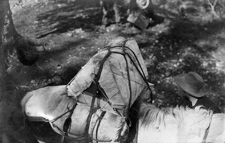
B.C. Yukon boundary survey season 1908 showing a packhorse packed with two tents and a valuable survey instrument. Note the diamond hitch on top of pack.
https://archives.whyte.org/en/permalink/descriptions49913
- Part Of
- Ernest C. W. Lamarque fonds
- Scope & Content
- Image of pack horse carrying two tents and survey equipment secured with a diamond hitch - man at right.
- Date Range
- 1908
- Reference Code
- v343 / 11 / 61 / na66 - 541
- Description Level
- 6 / Item
- GMD
- Photograph
- Negative, copy
1 image
- Part Of
- Ernest C. W. Lamarque fonds
- Description Level
- 6 / Item
- Fonds Number
- V343
- Reference Code
- v343 / 11 / 61 / na66 - 541
- Date Range
- 1908
- Physical Description
- 1 photograph : negative : copy negative
- Scope & Content
- Image of pack horse carrying two tents and survey equipment secured with a diamond hitch - man at right.
- Subject Access
- Discovery and Exploration
- Environment and Nature
- Labour
- Transportation
- Geographic Access
- Alberta
- British Columbia
- Creator
- Ernest Lamarque (?)
- Title Source
- copy negative envelope
Images
This material is presented as originally created; it may contain outdated cultural descriptions and
potentially offensive content.
Read more.
- Part Of
- Ernest C. W. Lamarque fonds
- Scope & Content
- Map showing passes, mountains, watersheds in the lower Rocky Mountains from Spray River to the Highwood River, n.d., 1 item. Maps traced from J.B. Tyrell and D.B. Dowling's exploration map of 1893 from Lac LaRonge, Saskatchewan to Lake Athabasca, Alberta, by Lamarque, 1964, 2 items. Map showing nor…
- Reference Code
- M81 / O.S. / "F"
- Part Of
- Ernest C. W. Lamarque fonds
- Accession Number
- 1286
- Reference Code
- M81 / O.S. / "F"
- Scope & Content
- Map showing passes, mountains, watersheds in the lower Rocky Mountains from Spray River to the Highwood River, n.d., 1 item.
- Maps traced from J.B. Tyrell and D.B. Dowling's exploration map of 1893 from Lac LaRonge, Saskatchewan to Lake Athabasca, Alberta, by Lamarque, 1964, 2 items.
- Map showing northerly end of Alaska-B.C. Highway Reconnaissance, 1939, 1 item.
- Map, St. Lawrence Region, 1963, 1 item.
- Map, National Topographic series, Reindeer Lake, N.W. 56/104, 1957, 1 item.
- Content Details
- Map held in oversize "F"
This material is presented as originally created; it may contain outdated cultural descriptions and
potentially offensive content.
Read more.
- Part Of
- Ernest C. W. Lamarque fonds
- Scope & Content
- Map of Northern Alberta showing round trip to Edmonton via the Peace, Slave and Athabasca Rivers. Map of Northern B.C. with sketched in route from Fort St. John to Telegraph Creek. Map showing route taken from Muskwa River to Whitewater (shows camps along route). Sketch map showing routes along Mus…
- Reference Code
- M81 / 13 / O.S. / "F"
- Part Of
- Ernest C. W. Lamarque fonds
- Accession Number
- 593
- Reference Code
- M81 / 13 / O.S. / "F"
- Scope & Content
- Map of Northern Alberta showing round trip to Edmonton via the Peace, Slave and Athabasca Rivers.
- Map of Northern B.C. with sketched in route from Fort St. John to Telegraph Creek.
- Map showing route taken from Muskwa River to Whitewater (shows camps along route).
- Sketch map showing routes along Muskwa River, Whitewater trip, 1934.
- Sketch map showing route along White River, 1934.
- Content Details
- Map held in oversize "F"
This material is presented as originally created; it may contain outdated cultural descriptions and
potentially offensive content.
Read more.
- Part Of
- Ernest C. W. Lamarque fonds
- Scope & Content
- Maps showing Rocky Mountain Trench from Aeroplane Lake to Watson Lake, shows part of Lamarque's route on Bedaux exploration, ca. 1934, 2 items.
- Reference Code
- M81 / 37 / O.S. / "F"
- Part Of
- Ernest C. W. Lamarque fonds
- Accession Number
- 1286
- Reference Code
- M81 / 37 / O.S. / "F"
- Scope & Content
- Maps showing Rocky Mountain Trench from Aeroplane Lake to Watson Lake, shows part of Lamarque's route on Bedaux exploration, ca. 1934, 2 items.
- Content Details
- Map held in oversize "F"
This material is presented as originally created; it may contain outdated cultural descriptions and
potentially offensive content.
Read more.