Narrow Results By
Geological Map of the Cascade Coal Sheet 1, Panther River No. 929
https://archives.whyte.org/en/permalink/catalogue24676
- Medium
- Library - Book (including soft-cover and pamphlets)
- Map
- Published Date
- 1904
- Call Number
- C7-1.1(a)
- Published Date
- 1904
- Scale
- 1 mile - 1 inch
- Subjects
- Cascade Coal Basin
- Alberta
- Notes
- To illustrate Report by D.B. Dowling, B.A.
- Accession Number
- 400 (Copy 2)
- Call Number
- C7-1.1(a)
- Collection
- Archives Library
This material is presented as originally created; it may contain outdated cultural descriptions and
potentially offensive content.
Read more.
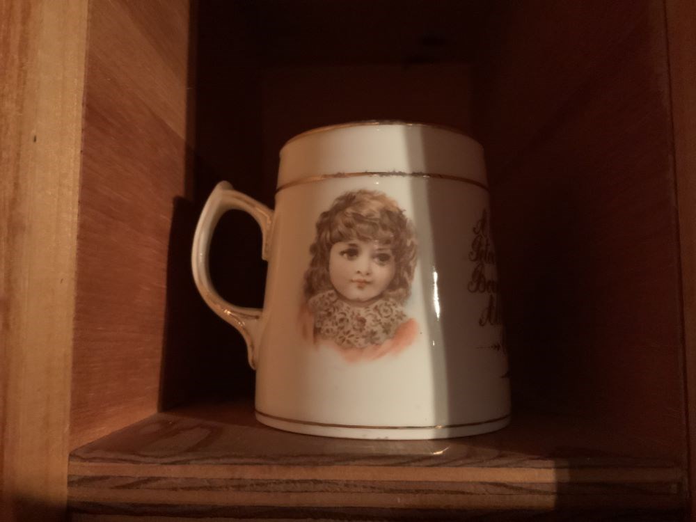
- Date
- 1905
- Material
- ceramic
- Catalogue Number
- 104.20.0542
- Description
- Ivory coloured mug with gold lustre trim decoration and writing, as well as two child portraits. Written "A Present to Peter R. Whyte Born 22nd Jan 1905 ...Alberta N.W.T. Canada".
1 image
- Title
- Mug
- Date
- 1905
- Material
- ceramic
- Dimensions
- 8.2 x 7.7 x 9.6 cm
- Description
- Ivory coloured mug with gold lustre trim decoration and writing, as well as two child portraits. Written "A Present to Peter R. Whyte Born 22nd Jan 1905 ...Alberta N.W.T. Canada".
- Subject
- households
- PW
- Alberta, NWT
- Credit
- Gift of Catharine Robb Whyte, O. C., Banff, 1979
- Catalogue Number
- 104.20.0542
Images
This material is presented as originally created; it may contain outdated cultural descriptions and
potentially offensive content.
Read more.
Sectional map, special edition, showing lands disposed of
https://archives.whyte.org/en/permalink/catalogue24593
- Medium
- Library - Maps and blueprints (unannotated; published)
- Map
- Published Date
- 1908
- Publisher
- Department of the Interior
- Call Number
- C11-6.16
- Publisher
- Department of the Interior
- Published Date
- 1908
- Scale
- 6 miles - 1 inch
- Notes
- References: Trails, Trails surveyed, Post Offices, Railway Stations, Range numbers
- Accession Number
- 400
- Call Number
- C11-6.16
- Collection
- Archives Library
This material is presented as originally created; it may contain outdated cultural descriptions and
potentially offensive content.
Read more.
National Topographic System
https://archives.whyte.org/en/permalink/catalogue23861
- Medium
- Library - Maps and blueprints (unannotated; published)
- Map
- Published Date
- 1960
- Publisher
- Dept. of Mines and Techinical Surveys
- Call Number
- NTS
- 82G/1E
- Publisher
- Dept. of Mines and Techinical Surveys
- Published Date
- 1960
- Physical Description
- 1 map : col
- Scale
- Scale: 1:50,000
- Relief: Contour interval 100 "
- Subjects
- Sage Creek
- British Columbia
- Alberta
- Call Number
- NTS
- 82G/1E
- Collection
- Archives Library
This material is presented as originally created; it may contain outdated cultural descriptions and
potentially offensive content.
Read more.
National Topographic System
https://archives.whyte.org/en/permalink/catalogue23862
- Medium
- Library - Maps and blueprints (unannotated; published)
- Map
- Published Date
- 1960
- Publisher
- Dept. of Mines and Technical Surveys
- Call Number
- NTS
- 82G/1W
- Publisher
- Dept. of Mines and Technical Surveys
- Published Date
- 1960
- Physical Description
- 1 map : col
- Scale
- Scale: 1:50,000
- Relief: Contour interval 100'
- Subjects
- Sage Creek
- British Columbia
- Alberta
- Call Number
- NTS
- 82G/1W
- Collection
- Archives Library
This material is presented as originally created; it may contain outdated cultural descriptions and
potentially offensive content.
Read more.
[Wildcat Hills 82 0/7 West - Alberta]
https://archives.whyte.org/en/permalink/catalogue23953
- Medium
- Library - Maps and blueprints (unannotated; published)
- Map
- Published Date
- 1960
- Publisher
- Dept. of Mines and Technical Surveys
- Call Number
- NTS
- 820/7W
- Publisher
- Dept. of Mines and Technical Surveys
- Published Date
- 1960
- Physical Description
- Colour
- Scale
- Scale: 1:50,000
- Relief: Contour interval 100'
- Subjects
- Wildcat Hills 82 0/7 West - Alberta
- Notes
- National Topographic System
- Call Number
- NTS
- 820/7W
- Collection
- Archives Library
This material is presented as originally created; it may contain outdated cultural descriptions and
potentially offensive content.
Read more.
The story of the mountains : Banff National Park
https://archives.whyte.org/en/permalink/catalogue19863
- Medium
- Library - Book (including soft-cover and pamphlets)
- Published Date
- 1960
- Author
- Belyea, Helen R.
- Publisher
- Ottawa [Queen's Printer]
- Call Number
- 13.115 B41s Pam
- Variant Title
- The story of the mountains in Banff National park
- Author
- Belyea, Helen R.
- Responsibility
- Helen R. Belyea
- Publisher
- Ottawa [Queen's Printer]
- Published Date
- 1960
- Physical Description
- 42 pages
- Abstract
- Pertains to the history of Banff National Park. The author, Helen R. Belyea, provides a comprehensive description and glossary pertaining to the type of rocks that makes up the mountains in Banff National Park. Additionally, she highlights specific areas of geological interest such as, but not limited to the following: Hoodoos viewpoint, Sulphur Mountain, Lake Minnewanka, Mount Norquay and the Hot Springs. Due to the nature of the publication, that being a Geological Survey of Canada, the author includes an excerpt on rock formation for each area marked as one of geological interest.
- Contents
- The rocks (pg. 4)
- The building of the mountains (pg. 12)
- Mountain sculpture (pg.13)
- Drainage patterns (pg. 17)
- Glossary of terms (pg. 18)
- References (pg. 23)
- Local points of geological interest (pg. 24)
- Photographs (pg. 43)
- Accession Number
- 2017.8683
- Call Number
- 13.115 B41s Pam
- Collection
- Archives Library
This material is presented as originally created; it may contain outdated cultural descriptions and
potentially offensive content.
Read more.
[Barrier Mountain 820/12 East, Alberta]
https://archives.whyte.org/en/permalink/catalogue23484
- Medium
- Library - Maps and blueprints (unannotated; published)
- Map
- Published Date
- 1960
- Publisher
- Dept. of Mines and Technical Surveys
- Call Number
- NTS
- 820/12E
- Publisher
- Dept. of Mines and Technical Surveys
- Published Date
- 1960
- Physical Description
- 1 map : col
- Scale
- Scale: 1:50,000
- Relief: Contour interval 100'
- Subjects
- Barrier Mountain
- Alberta
- Notes
- National Topographic System
- Accession Number
- 6283
- Call Number
- NTS
- 820/12E
- Collection
- Archives Library
This material is presented as originally created; it may contain outdated cultural descriptions and
potentially offensive content.
Read more.
[Barrier Mountain 820/12 West, Alberta]
https://archives.whyte.org/en/permalink/catalogue23485
- Medium
- Library - Maps and blueprints (unannotated; published)
- Map
- Published Date
- 1960
- Publisher
- Dept. of Mines and Technical Surveys
- Call Number
- NTS
- 820/12W
- Publisher
- Dept. of Mines and Technical Surveys
- Published Date
- 1960
- Physical Description
- 1 map : col
- Scale
- Scale: 1:50,000
- Relief: Contour interval 100'
- Subjects
- Barrier Mountain
- Alberta
- Notes
- National Topographic System
- Accession Number
- 6283
- Call Number
- NTS
- 820/12W
- Collection
- Archives Library
This material is presented as originally created; it may contain outdated cultural descriptions and
potentially offensive content.
Read more.
[Beaver Mines 82G/8 East, Alberta]
https://archives.whyte.org/en/permalink/catalogue23490
- Medium
- Library - Maps and blueprints (unannotated; published)
- Map
- Published Date
- 1960
- Publisher
- Dept of Mines and Techinical Surveys
- Call Number
- NTS
- 82G/8E
- Publisher
- Dept of Mines and Techinical Surveys
- Published Date
- 1960
- Scale
- Scale: 1 : 50,000
- Relief: Contour interval 100'
- Subjects
- Beaver Mines
- East Alberta
- Notes
- National Topographic System
- Call Number
- NTS
- 82G/8E
- Collection
- Archives Library
This material is presented as originally created; it may contain outdated cultural descriptions and
potentially offensive content.
Read more.