Narrow Results By
- Alpine Club of Canada 8
- Campbell, Carolyn 2
- Ward, Mrs. Humphrey (Mary Augusta Arnold) 2
- Alberta and British Columbia Boundary Commission 1
- Auld, Jerry 1
- Canada. Department of the Interior. Topographical Surveys Branch 1
- Chipman, K. G 1
- Chow, Lily 1
- Delehanty Pearkes, Eileen 1
- Douglas, David 1
- Gleason, Herbert W. 1
- Haworth, Paul Leland 1
A. O. Wheeler Hut Registers
https://archives.whyte.org/en/permalink/descriptions57639
- Part Of
- Alpine Club of Canada fonds
- Scope & Content
- Sub-series of hut registers from the A. O. Wheeler Hut produced by the Alpine Club of Canada between 1989 and 2016. Registers include entries from visitors to the huts which pertain to individuals' hiking and climbing trips; details of specific events which occurred while staying at the hut, wildli…
- Date Range
- 1989-2022
- Reference Code
- M200 / IV / D
- Description Level
- 4 / Sub-series
- GMD
- Textual record
- Organization record
- Part Of
- Alpine Club of Canada fonds
- Description Level
- 4 / Sub-series
- Fonds Number
- M200
- V14
- S6
- Series
- M200 / IV: Hut Registers
- Sous-Fonds
- M200
- Sub-Series
- M200 / IV / D: A. O. Wheeler Hut Registers
- Accession Number
- accn. 2023.10
- accn. 8002
- accn. 2014.8293
- accn. 2023.19
- accn. 2024.20
- Reference Code
- M200 / IV / D
- Responsibility
- Registers produced by the Alpine Club of Canada
- Date Range
- 1989-2022
- Physical Description
- 27 cm of textual records (11 volumes)
- History / Biographical
- The A. O. Wheeler Hut is located at Rogers Pass National Historic Site in Glacier National Park. The hut was built between 1945 and 1946, and it is a Recognized Federal Historic Building. The hut is named after one of the founding members of the Alpine Club of Canada, Arthur Oliver Wheeler. A. O. Wheeler was the first President of the Alpine Club of Canada, and he served as Honorary President of the Club for almost twenty years. According to the Alpine Club of Canada's website: "Carrying on the tradition of the Glacier House which was closed in 1925 and now exists only as a few concrete foundation pieces, the Wheeler Hut serves as a base for the legendary powder skiing of the Rogers Pass area. In summer there are numerous opportunities for climbing and hiking. This is the birthplace of alpinism in North America. Many of the routes are steeped in tradition and history, an interesting fact to remember as you reach for that next impeccable quartzite handhold or take that next footstep along one of the many trails which wind through the lush cedar forests that dominate the region. This is the one and only ACC hut which can be reached by vehicle in summer. Winter access is a mere 2 km along a well-broken and level trail. It is difficult to convey to the first time visitor the number and quality of the summer and winter day trips possible from the hut. The potential is outstanding from this single hut including summer hikes to Asulkan Pass or up the Great Glacier Trail to the Illecillewaet Glacier, summer climbs to Sapphire Col, Mt. Sir Donald, and Avalanche Peak; winter ski tours to Young’s Peak, the Seven Steps of Paradise, the Dome Glacier – the list goes on and on. Go and explore for yourself, you will not be disappointed! The Wheeler Hut is quite luxurious! A propane system provides the cooking and lighting, with two wood stoves for heating. The hut sleeps 30 in summer and 24 in winter."
- Scope & Content
- Sub-series of hut registers from the A. O. Wheeler Hut produced by the Alpine Club of Canada between 1989 and 2016. Registers include entries from visitors to the huts which pertain to individuals' hiking and climbing trips; details of specific events which occurred while staying at the hut, wildlife sightings, custodial issues and updates, and related topics. The sub-series is separated into individual hut registers, arranged by date:
- M200 / IV / D / 1: "A. O. Wheeler Hut Register" May 13, 1989 - Sept. 30, 1995
- M200 / IV / D / 2: Wheeler Hut register Oct. 6, 1995 - Mar. 28, 1998
- M200 / IV / D / 3: Wheeler Hut [1998 - 2000]
- M200 / IV / D / 4: A. O. Wheeler Hut Register 2000-2006
- M200 / IV / D / 5: A. O. Wheeler Hut 2001 - 2003
- M200 / IV / D / 6: A. O. Wheeler Hut Register 2003 - 2006
- M200 / IV / D / 7: The Wheeler Hut Registers. Part 1 of 2.
- M200 / IV / D / 8: The Wheeler Hut Registers. Part 2 of 2.
- M200 / IV / D / 9: [2009 - 2012 Wheeler Hut Register]
- M200 / IV / D / 10: 2013 - 2016 Wheeler Hut Register
- M200 / IV / D / 11: Wheeler Hut Register [2014-2022]
- Name Access
- Alpine Club of Canada
- Subject Access
- Huts
- Cabins and shelters
- Cabins
- Alpine Club of Canada
- Backcountry skiing
- British Columbia
- Buildings
- Buildings and facilities
- Climbing
- Club
- Environment and Nature
- Mountain
- Mountaineering
- National parks and reserves
- Parks Canada
- Provincial parks and reserves
- Winter sports
- Geographic Access
- Canada
- British Columbia
- Glacier National Park
- Rogers Pass
- Illecillewaet Valley
- Access Restrictions
- Restrictions may apply
- Reproduction Restrictions
- Contains personal information
- Language
- English
- Spanish
- French
- Biographical Source Notes
- The Alpine Club of Canada website: https://www.alpineclubofcanada.ca/a-o-wheeler-hut/ The Government of Canada - Parks Canada website: https://www.pc.gc.ca/apps/dfhd/page_fhbro_eng.aspx?id=11716
- Title Source
- Title based on contents of sub-series
- Processing Status
- Processed
This material is presented as originally created; it may contain outdated cultural descriptions and
potentially offensive content.
Read more.
Alberta caribou work continues while B.C. puts agreements in place
https://archives.whyte.org/en/permalink/catalogue25215
- Medium
- Library - Periodical
- Published Date
- 2020
- Author
- Campbell, Carolyn
- Publisher
- The Alberta Wilderness Association Journal
- Call Number
- P
1 website
- Author
- Campbell, Carolyn
- Responsibility
- Carolyn Campbell
- Publisher
- The Alberta Wilderness Association Journal
- Published Date
- 2020
- Physical Description
- pg. 12
- Medium
- Library - Periodical
- Subjects
- Caribou
- Wildlife
- Wildlife corridors
- Wildlife management
- First Nations
- Alberta
- British Columbia
- Abstract
- Pertains to updates on agreements Alberta and British Columbia are creating to protect extirpated caribou herds in both provinces and legal cases put forward by environmental groups and First Nations including Ecojustice, Athabasca Chipewyan First Nation, Mikisew Cree First Nation, David Suzuki Foundation. Other communities involved with caribou management plans including Cold Lake First Nation, Saulteau First Nations, West Moberly First Nations
- Notes
- In Wildlands Advocate, Vol. 28, No.3, September 2020
- Call Number
- P
- Collection
- Archives Library
- URL Notes
- Digital copy available
Websites
This material is presented as originally created; it may contain outdated cultural descriptions and
potentially offensive content.
Read more.
- Date
- 1917 – 1966
- Medium
- graphite; ink on paper
- Catalogue Number
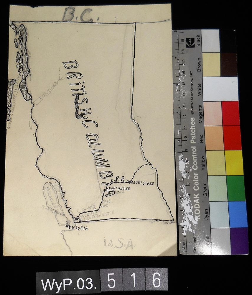
- WyP.03.516
- Description
- A pencil and ink drawing of a map of British Columbia. Notable is Highway 1 and the significant places through which it passes.
1 image
- Title
- B.C.
- Date
- 1917 – 1966
- Medium
- graphite; ink on paper
- Dimensions
- 22.5 x 15.1 cm
- Description
- A pencil and ink drawing of a map of British Columbia. Notable is Highway 1 and the significant places through which it passes.
- Credit
- Gift of Catharine Robb Whyte, O. C., Banff, 1975
- Catalogue Number
- WyP.03.516
Images
This material is presented as originally created; it may contain outdated cultural descriptions and
potentially offensive content.
Read more.
[Boundary Between Alberta and B.C.]
https://archives.whyte.org/en/permalink/catalogue24662
- Medium
- Library - Maps and blueprints (unannotated; published)
- Map
- Published Date
- 1916
- Edition
- Sheet #12
- Call Number
- C3-9.13
- Edition
- Sheet #12
- Published Date
- 1916
- Scale
- Scale: 1:62,500
- Relief: Contour interval 100 ft.
- Series
- Sheet #12
- Notes
- 2 duplicates in Map Room
- 2 photostat copies showing outline of Mt. Assiniboine Provincial Park
- Duplicate in Boundary Atlas #1
- Accession Number
- 44
- 400
- 3349
- 2949
- Call Number
- C3-9.13
- Collection
- Archives Library
This material is presented as originally created; it may contain outdated cultural descriptions and
potentially offensive content.
Read more.
[Boundary Between Alberta and B.C.]
https://archives.whyte.org/en/permalink/catalogue24664
- Medium
- Library - Maps and blueprints (unannotated; published)
- Map
- Published Date
- 1916
- Call Number
- C3-9.15
- Published Date
- 1916
- Scale
- Scale: 1:62,500
- Relief: Contour interval 100 ft.
- Series
- Sheet #15
- Notes
- Duplicate in Map Room
- Duplicate in Boundary Atlas #1
- Accession Number
- 400
- Call Number
- C3-9.15
- Collection
- Archives Library
This material is presented as originally created; it may contain outdated cultural descriptions and
potentially offensive content.
Read more.
[Boundary Between Alberta and B.C.]
https://archives.whyte.org/en/permalink/catalogue24665
- Medium
- Library - Maps and blueprints (unannotated; published)
- Map
- Published Date
- 1917
- Call Number
- C3-9.17, -9.18
- Published Date
- 1917
- Scale
- Scale: 1:62,500
- Relief: Contour interval 100 ft.
- Series
- Sheet #17, Sheet #18
- Notes
- Duplicate in Boundary Atlas #2
- Accession Number
- 718
- Call Number
- C3-9.17, -9.18
- Collection
- Archives Library
This material is presented as originally created; it may contain outdated cultural descriptions and
potentially offensive content.
Read more.
Boundary between Alberta and British Columbia / Interprovincial Boundary Commission
https://archives.whyte.org/en/permalink/catalogue21452
- Medium
- Library - Maps and blueprints (unannotated; published)
- Map
- Published Date
- ca. 1915-1917
- Publisher
- Ottawa : Surveyor General's Office
- Call Number
- C3-9.1-29b
- Publisher
- Ottawa : Surveyor General's Office
- Published Date
- ca. 1915-1917
- Physical Description
- 25 maps : col
- Notes
- In this sequence: 1-3, 5, 6-13A, 15, 17-20, 21, 25, 29, 29B
- Accession Number
- 2949
- Call Number
- C3-9.1-29b
- Collection
- Archives Library
This material is presented as originally created; it may contain outdated cultural descriptions and
potentially offensive content.
Read more.
[Boundary Between Alta. & B.C.]
https://archives.whyte.org/en/permalink/catalogue24669
- Medium
- Library - Maps and blueprints (unannotated; published)
- Map
- Published Date
- 1917
- Call Number
- C3-9.29A, -9.29B
- Published Date
- 1917
- Scale
- Scale: 1:25,000
- Relief: Contour interval 100 ft.
- Series
- Sheets #29A & 29B
- Notes
- Duplicate in Boundary Atlas #3
- Call Number
- C3-9.29A, -9.29B
- Collection
- Archives Library
This material is presented as originally created; it may contain outdated cultural descriptions and
potentially offensive content.
Read more.
[Boundary Between Alta. and B.C.]
https://archives.whyte.org/en/permalink/catalogue24666
- Medium
- Library - Maps and blueprints (unannotated; published)
- Map
- Published Date
- 1917
- Call Number
- C3-9.18A
- Published Date
- 1917
- Scale
- Scale: 1:25,000
- Relief: Contour interval 100 ft.
- Series
- Sheet #18A
- Notes
- Duplicate in Boundary Atlas #2
- Accession Number
- 718
- Call Number
- C3-9.18A
- Collection
- Archives Library
This material is presented as originally created; it may contain outdated cultural descriptions and
potentially offensive content.
Read more.
[Boundary Between Alta. and B.C.]
https://archives.whyte.org/en/permalink/catalogue24667
- Medium
- Library - Maps and blueprints (unannotated; published)
- Map
- Published Date
- 1918-1919
- Call Number
- C3-9.10, -9.20, -9.21
- Published Date
- 1918-1919
- Scale
- Scale: 1:62,500
- Relief: Contour interval 100 ft.
- Series
- Sheets #19, 20, 21
- Notes
- Duplicate of #20
- Duplicates in Boundary Atlas #2
- Accession Number
- 718
- Call Number
- C3-9.10, -9.20, -9.21
- Collection
- Archives Library
This material is presented as originally created; it may contain outdated cultural descriptions and
potentially offensive content.
Read more.