Narrow Results By
The Great Lakes and the States that Bound Them
https://archives.whyte.org/en/permalink/artifactwyp.03.514
- Date
- 1917 – 1966
- Medium
- ink on paper
- Catalogue Number
- WyP.03.514
- Description
- Ink drawing of a geographic perspective of the Great Lakes region, including the states that border on Canada
1 image
- Title
- The Great Lakes and the States that Bound Them
- Date
- 1917 – 1966
- Medium
- ink on paper
- Dimensions
- 15.1 x 22.5 cm
- Description
- Ink drawing of a geographic perspective of the Great Lakes region, including the states that border on Canada
- Subject
- map
- Great Lakes
- Canada
- United States
- geography
- Credit
- Gift of Catharine Robb Whyte, O. C., Banff, 1975
- Catalogue Number
- WyP.03.514
Images

This material is presented as originally created; it may contain outdated cultural descriptions and
potentially offensive content.
Read more.
- Date
- 1917 – 1966
- Medium
- ink on drawing
- Catalogue Number
- WyP.03.515
- Description
- An ink drawing of a map of Saskatchewan on paper. Labelled SASKATEWAN [sic] in centre, written vertically towards the top edge.
1 image
- Title
- Untitled
- Date
- 1917 – 1966
- Medium
- ink on drawing
- Dimensions
- 22.5 x 15.1 cm
- Description
- An ink drawing of a map of Saskatchewan on paper. Labelled SASKATEWAN [sic] in centre, written vertically towards the top edge.
- Subject
- map
- Saskatchewan
- province
- Canada
- geography
- Credit
- Gift of Catharine Robb Whyte, O. C., Banff, 1975
- Catalogue Number
- WyP.03.515
Images

This material is presented as originally created; it may contain outdated cultural descriptions and
potentially offensive content.
Read more.
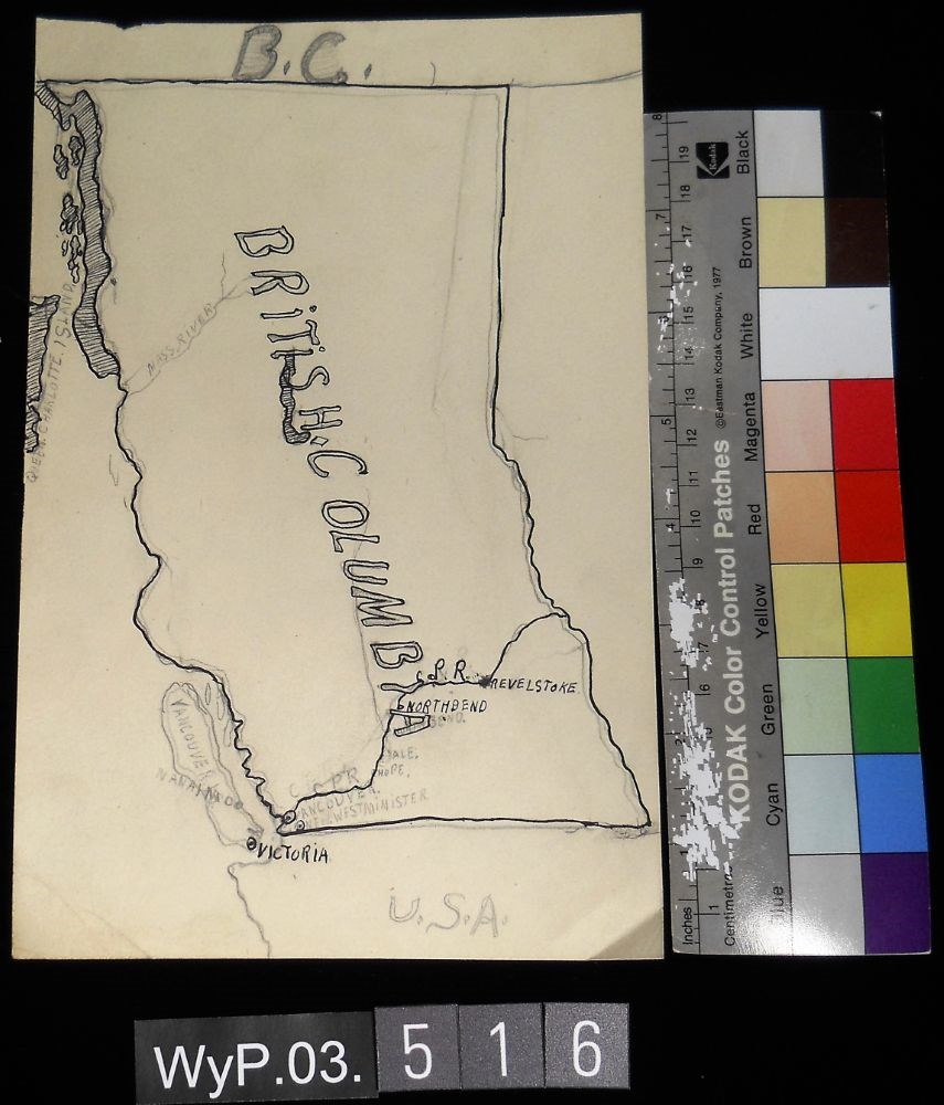
- Date
- 1917 – 1966
- Medium
- graphite; ink on paper
- Catalogue Number
- WyP.03.516
- Description
- A pencil and ink drawing of a map of British Columbia. Notable is Highway 1 and the significant places through which it passes.
1 image
- Title
- B.C.
- Date
- 1917 – 1966
- Medium
- graphite; ink on paper
- Dimensions
- 22.5 x 15.1 cm
- Description
- A pencil and ink drawing of a map of British Columbia. Notable is Highway 1 and the significant places through which it passes.
- Credit
- Gift of Catharine Robb Whyte, O. C., Banff, 1975
- Catalogue Number
- WyP.03.516
Images
This material is presented as originally created; it may contain outdated cultural descriptions and
potentially offensive content.
Read more.
- Date
- 1917 – 1966
- Medium
- ink; graphite on paper
- Catalogue Number
- WyP.03.519
- Description
- A pencil and ink drawing of the outline of the South American continent.
1 image
- Title
- Untitled
- Date
- 1917 – 1966
- Medium
- ink; graphite on paper
- Dimensions
- 22.5 x 15.1 cm
- Description
- A pencil and ink drawing of the outline of the South American continent.
- Subject
- South America
- outline
- geography
- Credit
- Gift of Catharine Robb Whyte, O. C., Banff, 1975
- Catalogue Number
- WyP.03.519
Images

This material is presented as originally created; it may contain outdated cultural descriptions and
potentially offensive content.
Read more.
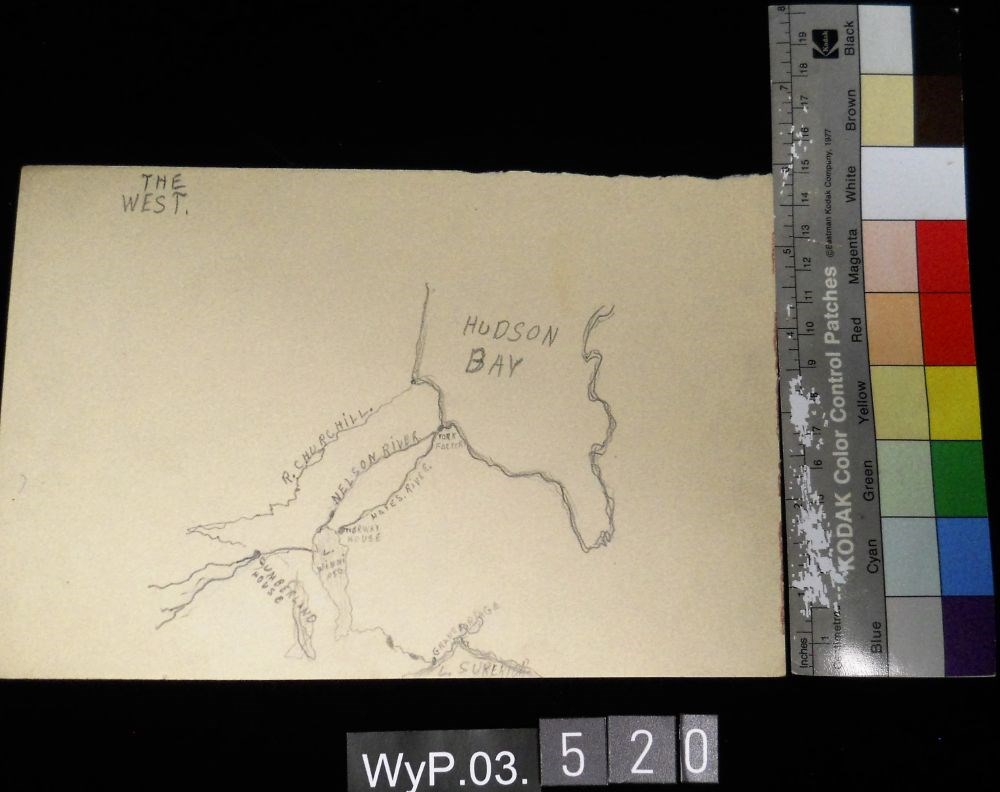
- Date
- 1917 – 1966
- Medium
- graphite on paper
- Catalogue Number
- WyP.03.520
- Description
- A pencil drawing of the Hudson Bay and the rivers that flow from it.
1 image
- Title
- The West
- Date
- 1917 – 1966
- Medium
- graphite on paper
- Dimensions
- 15.1 x 22.5 cm
- Description
- A pencil drawing of the Hudson Bay and the rivers that flow from it.
- Subject
- Hudson Bay
- Canada
- geography
- water
- river
- Credit
- Gift of Catharine Robb Whyte, O. C., Banff, 1975
- Catalogue Number
- WyP.03.520
Images
This material is presented as originally created; it may contain outdated cultural descriptions and
potentially offensive content.
Read more.
- Date
- 1917 – 1929
- Medium
- graphite on paper
- Catalogue Number
- WyP.03.583
- Description
- A pencil drawing of the outline of the South American continent. Drawing occupies entire paper.
1 image
- Title
- Untitled
- Date
- 1917 – 1929
- Medium
- graphite on paper
- Dimensions
- 22.5 x 15.1 cm
- Description
- A pencil drawing of the outline of the South American continent. Drawing occupies entire paper.
- Subject
- South America
- map
- geography
- cartography
- Credit
- Gift of Catharine Robb Whyte, O. C., Banff, 1979
- Catalogue Number
- WyP.03.583
Images

This material is presented as originally created; it may contain outdated cultural descriptions and
potentially offensive content.
Read more.
Map Drawing Book For Use in Public Schools
https://archives.whyte.org/en/permalink/artifactwyp.03.584
- Date
- c. 1914
- Medium
- graphite on paper
- Catalogue Number
- WyP.03.584
- Description
- Peter Whyte’s Map Drawing sketchbook, likely an exercise book for school, with a printed cover page and map drawings inside. Cover page reads: MAP DRAWING BOOK [across top]; FOR USE IN THE PUBLIC SCHOOLS/ THE COPP, CLARK CO., LIMITED, TORONTO [across bottom] Inside, pencil drawings include: the Gul…
1 image
- Title
- Map Drawing Book For Use in Public Schools
- Date
- c. 1914
- Medium
- graphite on paper
- Dimensions
- 24.9 x 31.0 cm
- Description
- Peter Whyte’s Map Drawing sketchbook, likely an exercise book for school, with a printed cover page and map drawings inside. Cover page reads: MAP DRAWING BOOK [across top]; FOR USE IN THE PUBLIC SCHOOLS/ THE COPP, CLARK CO., LIMITED, TORONTO [across bottom] Inside, pencil drawings include: the Gulf of St. Lawrence, the Philippine Islands, Asia and the Middle East, and Africa.
- Subject
- world
- map
- globe
- geography
- cartography
- Asia
- Middle East
- Africa
- Philippine Islands
- Gulf of St. Lawrence
- Credit
- Gift of Catharine Robb Whyte, O. C., Banff, 1975
- Catalogue Number
- WyP.03.584
Images

This material is presented as originally created; it may contain outdated cultural descriptions and
potentially offensive content.
Read more.
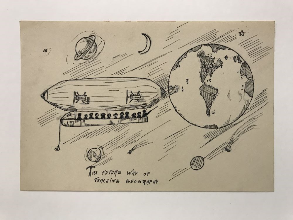
The Future way of Teaching Geography
https://archives.whyte.org/en/permalink/artifactwyp.03.928
- Date
- 1925 – 1966
- Medium
- graphite; ink on paper
- Catalogue Number
- WyP.03.928
- Description
- An blimp/Zeppelin carries a group of people in space where they are looking at the different planets and stars, though Earth is the most prominent in the sky. Below the drawing it says “THE FUTURE WAY OF TEACHING GEOGRAPHY”
1 image
- Title
- The Future way of Teaching Geography
- Date
- 1925 – 1966
- Medium
- graphite; ink on paper
- Dimensions
- 15.0 x 22.5 cm
- Description
- An blimp/Zeppelin carries a group of people in space where they are looking at the different planets and stars, though Earth is the most prominent in the sky. Below the drawing it says “THE FUTURE WAY OF TEACHING GEOGRAPHY”
- Subject
- airship
- blimp
- Zeppelin
- aircraft
- flying
- space
- travel
- people
- passengers
- education
- star
- planet
- Earth
- geography
- Credit
- Gift of Catharine Robb Whyte, O. C., Banff, 1979
- Catalogue Number
- WyP.03.928
Images
This material is presented as originally created; it may contain outdated cultural descriptions and
potentially offensive content.
Read more.