Narrow Results By
Antique Maps of India and Germany, Walter Wilcox Mounts
https://archives.whyte.org/en/permalink/descriptions54204
- Part Of
- Nicholas Morant fonds
- Scope & Content
- File consists of 13 antique maps, 6 of which depict regions in India and 7 which depict regions in Germany. Content pertains to a small map collection originally issued to Tim Ffrench (?) during WWII which were later owned by Nicholas Morant. Some maps of reserves contain personal annotations and h…
- Date Range
- 1868
- 1892
- 1894
- 1903
- 1904
- 1917
- 1921
- 1950
- Reference Code
- M300 / III / D / 5 / 54 to 66 O.S. & V500 / III / D / 5 / PA - 96 O.S.
- Description Level
- 5 / File
- GMD
- Map
- Textual record
- Part Of
- Nicholas Morant fonds
- Description Level
- 5 / File
- Fonds Number
- V500
- Sous-Fonds
- V500
- Sub-Series
- M300 & V500 / III / D / 5 : Personal Interest and Gifts
- Accession Number
- 7784
- Reference Code
- M300 / III / D / 5 / 54 to 66 O.S. & V500 / III / D / 5 / PA - 96 O.S.
- GMD
- Map
- Textual record
- Other Title Info
- Parallel title is original title
- Responsibility
- Nicholas Morant
- Date Range
- 1868
- 1892
- 1894
- 1903
- 1904
- 1917
- 1921
- 1950
- Physical Description
- 13 Maps: print; b&w, and set of 4 rag paper mounts
- Scope & Content
- File consists of 13 antique maps, 6 of which depict regions in India and 7 which depict regions in Germany. Content pertains to a small map collection originally issued to Tim Ffrench (?) during WWII which were later owned by Nicholas Morant. Some maps of reserves contain personal annotations and highlighted/coloured routes; none of German maps are annotated. File also contains set of 4 rag paper mounts, annotated. 3 naming artist Walter Wilcox (likely formerly held his works but are now blank). One labelled 'Model'.
- Notes
- Maps were originally stored together in one poster tube labelled: "MAPS OF GERMANY INDIA See notes inside" Shipping label: PLS HOLD Armand To Nicholas Morant 222 Melville Ave Westmount Montreal" (with two 3 - cent stamps attached) Note inside, written by Nicholas Morant: "These maps were among those issued to Capt. Tim Ffrench (?) preparatory to intelligence work done during W. War II" Signed "Nick M." Wilcox mounts were stored in brown paper packaging with several other blank mounts (disposed of). Labelled section of original paper packaging has been stored with mounts in oversize box for reference.
- Geographic Access
- Germany
- India
- Access Restrictions
- Items in this file are not to be accessed or distributed without the explicit permission of their identified owners
- Reproduction Restrictions
- Items in this file are not to be reproduced without the explicit permission of their identified owners.
- Language
- English
- German
- Conservation
- Items must be kept only with items of similar materials, and stored with protective acid-free barriers to prevent further damage.
- Title Source
- Title based on contents of file
- Processing Status
- Processed
This material is presented as originally created; it may contain outdated cultural descriptions and
potentially offensive content.
Read more.
Author's copy of Geology Road Tours
https://archives.whyte.org/en/permalink/descriptions56293
- Part Of
- Ben Gadd fonds
- Scope & Content
- File consists of one author's copy of Ben Gadd's book, Geology Road Tours, which includes corrections and other annotations by the author.
- Date Range
- 2008
- Reference Code
- M590 / II / B / 59
- Description Level
- 5 / File
- GMD
- Textual record
- Published record
- Part Of
- Ben Gadd fonds
- Description Level
- 5 / File
- Fonds Number
- M590
- V810
- S61
- Series
- M590 / II : Research and publication records
- Sous-Fonds
- M590
- Sub-Series
- M590 / II / B : Other publications
- Accession Number
- 2021.20
- Reference Code
- M590 / II / B / 59
- Responsibility
- Produced by Ben Gadd, Corax Press
- Date Range
- 2008
- Physical Description
- 3.5 cm of textual records : 1 volume ; 15.5 x 23 cm
- Scope & Content
- File consists of one author's copy of Ben Gadd's book, Geology Road Tours, which includes corrections and other annotations by the author.
- Name Access
- Gadd, Ben
- Subject Access
- Publication
- Commercial products
- Environment
- Geology
- Science and technology
- Geography
- Natural history
- Travel
- Roads
- Map
- Geographic Access
- Canada
- Alberta
- British Columbia
- Canadian Rocky Mountains
- Reproduction Restrictions
- Copyright restrictions may apply
- Language
- English
- Title Source
- Title based on contents of file
- Processing Status
- Processed
This material is presented as originally created; it may contain outdated cultural descriptions and
potentially offensive content.
Read more.
Auyuittuq National Park
https://archives.whyte.org/en/permalink/descriptions54979
- Part Of
- Murray Hay fonds
- Scope & Content
- File consists of 1 painting : landscape ; 50.5 x 39.5 cm. File pertains to a map Murray Hay created of Auyuittuq National Park in Nunavut, Canada. File includes 1 colour painting of the park and surrounding area (Nunavut, Baffin Island) and one sheet of tracing paper that is annotated and taped wit…
- Date Range
- ca.1980-ca.1989
- Reference Code
- V795 / II / C / vi / 1
- Description Level
- 5 / File
- GMD
- Map
- Painting
- Private record
- Part Of
- Murray Hay fonds
- Description Level
- 5 / File
- Fonds Number
- M570 / V795
- Series
- V795 / II : Unpublished Material
- Sous-Fonds
- V795
- Sub-Series
- V795 / II / C : Canada [general] / vi : Auyuittuq National Park
- Accession Number
- 2020.03
- Reference Code
- V795 / II / C / vi / 1
- Date Range
- ca.1980-ca.1989
- Physical Description
- 1 painting : landscape ; 50.5 x 39.5 cm
- Scope & Content
- File consists of 1 painting : landscape ; 50.5 x 39.5 cm. File pertains to a map Murray Hay created of Auyuittuq National Park in Nunavut, Canada. File includes 1 colour painting of the park and surrounding area (Nunavut, Baffin Island) and one sheet of tracing paper that is annotated and taped with masking tape over the painting.
- Name Access
- Hay, Murray
- Subject Access
- Advertising
- Artist
- Map
- Cartography
- Painting
- Geography
- Tourism
- Tourist information
- Travel
- National parks and reserves
- Auyuittuq National Park
- Geographic Access
- Auyuittuq National Park
- Nunavut
- Canada
- Language
- English
- Conservation
- Masking tape should be removed and alternative preservation methods should be considered at a reasonable time to do so.
- Creator
- Hay, Murray
- Title Source
- Title based on contents of file
- Processing Status
- Processed
This material is presented as originally created; it may contain outdated cultural descriptions and
potentially offensive content.
Read more.
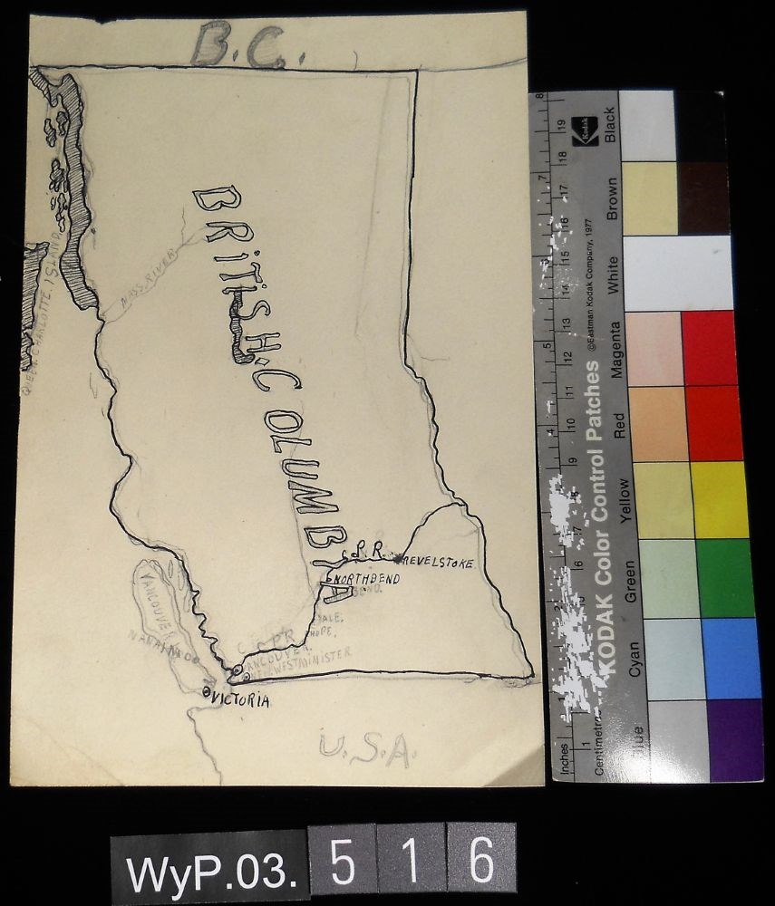
- Date
- 1917 – 1966
- Medium
- graphite; ink on paper
- Catalogue Number
- WyP.03.516
- Description
- A pencil and ink drawing of a map of British Columbia. Notable is Highway 1 and the significant places through which it passes.
1 image
- Title
- B.C.
- Date
- 1917 – 1966
- Medium
- graphite; ink on paper
- Dimensions
- 22.5 x 15.1 cm
- Description
- A pencil and ink drawing of a map of British Columbia. Notable is Highway 1 and the significant places through which it passes.
- Credit
- Gift of Catharine Robb Whyte, O. C., Banff, 1975
- Catalogue Number
- WyP.03.516
Images
This material is presented as originally created; it may contain outdated cultural descriptions and
potentially offensive content.
Read more.
Bill Peyto guide to Canadian Rockies trivia : volume 1
https://archives.whyte.org/en/permalink/catalogue12062
- Medium
- Library - Book (including soft-cover and pamphlets)
- Published Date
- 2003
- Author
- Peyto, David W
- Publisher
- Calgary : Peyto Lake Books
- Call Number
- 02.6 P46 v.1
- Author
- Peyto, David W
- Publisher
- Calgary : Peyto Lake Books
- Published Date
- 2003
- Physical Description
- 125 p
- ISBN
- 0973106611
- Accession Number
- 7474
- Call Number
- 02.6 P46 v.1
- Collection
- Archives Library
This material is presented as originally created; it may contain outdated cultural descriptions and
potentially offensive content.
Read more.

Bill Peyto guide to Canadian Rockies trivia : volume 2
https://archives.whyte.org/en/permalink/catalogue12063
- Medium
- Library - Book (including soft-cover and pamphlets)
- Published Date
- 2003
- Author
- Peyto, David W
- Publisher
- Calgary : Peyto Lake Books
- Call Number
- 02.6 P46 v.2
- Author
- Peyto, David W
- Publisher
- Calgary : Peyto Lake Books
- Published Date
- 2003
- Physical Description
- 121 p
- ISBN
- 0-9731066-2-X
- Accession Number
- 7474
- Call Number
- 02.6 P46 v.2
- Collection
- Archives Library
This material is presented as originally created; it may contain outdated cultural descriptions and
potentially offensive content.
Read more.

Blueprints of Connaught Tunnel and Map of Deutchman Cave
https://archives.whyte.org/en/permalink/descriptions54207
- Part Of
- Nicholas Morant fonds
- Scope & Content
- File consists of 2 printed paper copies of older hand-illustrated works. Pertains to a copied 1947 blueprint of Connaught Tunnel depicting burn damage on tracks from an accident that year; and a copied hand-drawn map of Deutchman Cave from 1902, with annotations bottom right (copied from the origin…
- Date Range
- [ca. 1950 - ca. 1970]
- Reference Code
- V500 / III / D / 5 / PA - 73 to 74 O.S.
- Description Level
- 5 / File
- GMD
- Drawing
- Map
- Blueprint
- Part Of
- Nicholas Morant fonds
- Description Level
- 5 / File
- Fonds Number
- M300 / S20 / V500
- Sous-Fonds
- V500
- Sub-Series
- V500 / III / D / 5 : Personal Interest and Gifts
- Accession Number
- 7784
- Reference Code
- V500 / III / D / 5 / PA - 73 to 74 O.S.
- Responsibility
- Nicholas Morant
- Date Range
- [ca. 1950 - ca. 1970]
- Physical Description
- 2 paper copies: 1 blueprint, 1 map
- Scope & Content
- File consists of 2 printed paper copies of older hand-illustrated works. Pertains to a copied 1947 blueprint of Connaught Tunnel depicting burn damage on tracks from an accident that year; and a copied hand-drawn map of Deutchman Cave from 1902, with annotations bottom right (copied from the original).
- Notes
- Items were stored together in a poster tube labelled: "Canadian Pacific Blueprints - CPR Passenger Train in Connaught Tunnel - Nakimu Caves at Glacier"
- Subject Access
- Geography
- Connaught Tunnel
- Canadian Pacific Railway
- Train
- Transportation
- Geographic Access
- Canada
- British Columbia
- Canadian Rocky Mountains
- Access Restrictions
- Items in this file are not to be accessed or distributed without the explicit permission of their identified copyright owners.
- Reproduction Restrictions
- Items in this file are not to be reproduced without the explicit permission of their identified copyright owners.
- Language
- English
- Conservation
- Items must be stored flat with similar materials
- Creator
- Nicholas Morant
- Title Source
- Title based on contents of file
- Processing Status
- Processed
This material is presented as originally created; it may contain outdated cultural descriptions and
potentially offensive content.
Read more.
Brochure production
https://archives.whyte.org/en/permalink/descriptions54929
- Scope & Content
- File consists of notes, clippings and drafts of brochures to be published by the Trail Riders of the Canadian Rockies. File also includes several illustrations of trail maps to be included in brochures, correspondence pertaining to brochure production, model release forms and three duplicate b&w pr…
- Date Range
- 1980-1985
- Reference Code
- M545 / V / 29 & 30
- Description Level
- 5 / File
- GMD
- Textual record
- Published record
- Organization record
- Description Level
- 5 / File
- Fonds Number
- M545 / V635
- Series
- M545 / V : Administrative records
- Sous-Fonds
- M545
- Accession Number
- 5939
- Reference Code
- M545 / V / 29 & 30
- Date Range
- 1980-1985
- Physical Description
- 2.5 cm of textual records (21.5 x 28 cm or smaller) -- 3 photographs : b&w prints ; 9 x 9 cm
- Scope & Content
- File consists of notes, clippings and drafts of brochures to be published by the Trail Riders of the Canadian Rockies. File also includes several illustrations of trail maps to be included in brochures, correspondence pertaining to brochure production, model release forms and three duplicate b&w prints depicting several trail riders on horseback [image used in 1980 brochure].
- Notes
- Six "Holiday on Horseback" brochures removed from file. Items are duplicates of brochures processed in series M545 / II and will be offered for return to Trail Riders of the Canadian Rockies.
- File contents organized by date and stored in two folders [see "Content Details"]
- Subject Access
- Administration
- Advertising
- Tourism
- Travel
- Organizations
- Membership
- Businesses
- Geography
- Horse packing
- Horseback riding
- Trails
- Hotels
- Geographic Access
- Canada
- Alberta
- Calgary
- Banff
- Language
- English
- Conservation
- Prints placed in mylar and stored in folder with related textual material to preserve context
- Category
- Exploration, discovery and travel
- Sports, recreation and leisure
- Communications
- Commerce and industry
- Title Source
- Title based on contents of file
- Processing Status
- Processed
This material is presented as originally created; it may contain outdated cultural descriptions and
potentially offensive content.
Read more.
Camp coordinator packages, notes and handouts
https://archives.whyte.org/en/permalink/descriptions54472
- Scope & Content
- File consists of introductory packages put together for Camp Coordinators on pack trips led by the Trail Riders of the Canadian Rockies in 2008. File includes contact lists, name lists and basic information about riders, participant reports, printed maps and brochures pertaining to specific packing…
- Date Range
- 2008
- Reference Code
- M545 / II / 14
- Description Level
- 5 / File
- GMD
- Textual record
- Organization record
- Map
- Postcard
- Description Level
- 5 / File
- Fonds Number
- M545 / V635
- Series
- M545 / II : Members, Staff, Personal Content
- Sous-Fonds
- M545
- Accession Number
- 8235
- Reference Code
- M545 / II / 14
- Date Range
- 2008
- Physical Description
- 1.5 cm of textual records
- Scope & Content
- File consists of introductory packages put together for Camp Coordinators on pack trips led by the Trail Riders of the Canadian Rockies in 2008. File includes contact lists, name lists and basic information about riders, participant reports, printed maps and brochures pertaining to specific packing trips in 2008, blank survey sheets and insurance waivers, and itineraries. Items are kept in order of 2008 ride numbers: Ride 1, Ride 2, etc.
- Notes
- Contains numerous duplicates
- Subject Access
- Administration
- Packing
- Travel
- Tourism
- Geography
- Geographic Access
- Canada
- Alberta
- Kananaskis
- Banff
- Access Restrictions
- Restrictions may apply due to personal information
- Reproduction Restrictions
- Restrictions may apply due to personal information
- Language
- English
- Category
- Sports, recreation and leisure
- Title Source
- Title based on contents of file
- Processing Status
- Processed
This material is presented as originally created; it may contain outdated cultural descriptions and
potentially offensive content.
Read more.
Canada's Great Highway and The Rockies of Canada
https://archives.whyte.org/en/permalink/descriptions54158
- Part Of
- Nicholas Morant fonds
- Scope & Content
- File consists of 2 published books. Contains 1 copy of 'Canada's Great Highway: from the First Stake to the Last Spike' by J.H.E. Secretan (1924), annotated by Nicholas Morant; and 1 copy of 'The Rockies of Canada' by Walter D. Wilcox (1909) with topographical map of the Rocky Mountain region in ba…
- Date Range
- 1909
- 1924
- Reference Code
- M300 / III / D / 5 / 46 to 47
- Description Level
- 5 / File
- GMD
- Textual record
- Published record
- Map
- Part Of
- Nicholas Morant fonds
- Description Level
- 5 / File
- Fonds Number
- M300 / S20 / V500
- Sous-Fonds
- M300
- Sub-Series
- M300 / III / D / 5 : Personal Interest and Gifts
- Accession Number
- 7784
- Reference Code
- M300 / III / D / 5 / 46 to 47
- Responsibility
- Produced by J.H.E. Secretan and Walter D. Wilcox
- Date Range
- 1909
- 1924
- Physical Description
- 2 Textual records: books
- Scope & Content
- File consists of 2 published books. Contains 1 copy of 'Canada's Great Highway: from the First Stake to the Last Spike' by J.H.E. Secretan (1924), annotated by Nicholas Morant; and 1 copy of 'The Rockies of Canada' by Walter D. Wilcox (1909) with topographical map of the Rocky Mountain region in back pocket.
- Storage Range
- In file box M300 / III / D / 5 / 46 to M300 / III / D / 5 / 47.
- Geographic Access
- Canada
- Canadian Rocky Mountains
- Access Restrictions
- Items in this file are not to be accessed or distributed without the explicit permission of their identified copyright owners.
- Reproduction Restrictions
- Items in this file are not to be reproduced without the explicit permission of their identified copyright owners.
- Language
- English
- Conservation
- Items in this file with risky materials attached, such as adhesives, must be covered with an acid-free paper barrier to protect adjacent items.
- Creator
- Nicholas Morant
- Title Source
- Title based on contents of file
- Processing Status
- Processed
This material is presented as originally created; it may contain outdated cultural descriptions and
potentially offensive content.
Read more.