Narrow Results By
- Part Of
- Murray Hay fonds
- Scope & Content
- File consists of 144 photographs : col. negatives ; 35 m m; 12 prints : col. ; 42 x 35 cm or smaller ; 1 cm of visual material. File pertains to various projects Murray Hay was involved with related to Alaska, USA, particularly in the mid-1990s. File includes: aerial photographs of the landscape (A…
- Date Range
- ca.1990-ca.1999
- 1992
- 1994
- Reference Code
- V795 / II / D / i / 1-2
- Description Level
- 5 / File
- GMD
- Drawing
- Map
- Photograph print
- Negative
- Private record
- Textual record
- Part Of
- Murray Hay fonds
- Description Level
- 5 / File
- Fonds Number
- M570 / V795
- Series
- V795 / II : Unpublished Material
- Sous-Fonds
- V795
- Sub-Series
- V795 / II / D : International / i : United States of America
- Accession Number
- 2019.41
- Reference Code
- V795 / II / D / i / 1-2
- Date Range
- ca.1990-ca.1999
- 1992
- 1994
- Physical Description
- 144 photographs : col. negatives ; 35 mm
- 12 prints : col. ; 42 x 35 cm or smaller
- 1 cm of visual material
- Scope & Content
- File consists of 144 photographs : col. negatives ; 35 m m; 12 prints : col. ; 42 x 35 cm or smaller ; 1 cm of visual material. File pertains to various projects Murray Hay was involved with related to Alaska, USA, particularly in the mid-1990s. File includes: aerial photographs of the landscape (Anchorage area, Homer, Prince William Sound, Valdez); hand-drawn draft maps of the Prince William Sound region (created for a cruise line); a variety of printed maps with annotations demonstrating comments (including a fax with an attached map from Dana at Adventure Media International); and a variety of printed reproductions of draft maps (Alyeska Ski Resort, City of Anchorage for the 1992 Olympic Bid, and Glacier Bay and the Tongass National Forest).
- Notes
- Items not in oversize (negatives) stored in downstairs vault.
- Name Access
- Hay, Murray
- Subject Access
- Advertising
- Artist
- Ski Maps
- Map
- Cartography
- Sports and recreation
- Tourism
- Tourist information
- Travel
- Geography
- Winter
- Winter sports
- Ski area
- Olympic Games (Winter)
- Geographic Access
- Alaska
- United States
- Valdez
- Prince William Sound
- Anchorage
- Glacier Bay and Tongass National Forest
- Language
- English
- Conservation
- Masking tape should be removed and alternative preservation methods used in the future.
- Related Material
- M570 / IV / A / 2-3
- Creator
- Hay, Murray
- Title Source
- Title based on contents of file
- Processing Status
- Processed
This material is presented as originally created; it may contain outdated cultural descriptions and
potentially offensive content.
Read more.
- Part Of
- Murray Hay fonds
- Scope & Content
- File consists of 1 map : col., annotations, 96.5 x 69 cm. File pertains to an original unfinished hand-drawn map of interior Arizona in red, blue, black, and purple ink. Includes geographic features and labeled cities (including Yuma, Nogales, Bisbee, and Flagstaff).
- Date Range
- ca.1990-ca.1999
- Reference Code
- V795 / II / D / i / 4
- Description Level
- 5 / File
- GMD
- Drawing
- Map
- Private record
- Textual record
- Part Of
- Murray Hay fonds
- Description Level
- 5 / File
- Fonds Number
- M570 / V795
- Series
- V795 / II : Unpublished Material
- Sous-Fonds
- V795
- Sub-Series
- V795 / II / D : International / i : United States of America
- Accession Number
- 2019.41
- Reference Code
- V795 / II / D / i / 4
- Date Range
- ca.1990-ca.1999
- Physical Description
- 1 map : col., annotations ; 96.5 x 69 cm
- Scope & Content
- File consists of 1 map : col., annotations, 96.5 x 69 cm. File pertains to an original unfinished hand-drawn map of interior Arizona in red, blue, black, and purple ink. Includes geographic features and labeled cities (including Yuma, Nogales, Bisbee, and Flagstaff).
- Name Access
- Hay, Murray
- Subject Access
- Advertising
- Artist
- Ski Maps
- Map
- Cartography
- Sports and recreation
- Tourism
- Tourist information
- Travel
- Geography
- Winter
- Winter sports
- Ski area
- Geographic Access
- Arizona
- United States
- Language
- English
- Creator
- Hay, Murray
- Title Source
- Title based on contents of file
- Processing Status
- Processed
This material is presented as originally created; it may contain outdated cultural descriptions and
potentially offensive content.
Read more.
Author's copy of Geology Road Tours
https://archives.whyte.org/en/permalink/descriptions56293
- Part Of
- Ben Gadd fonds
- Scope & Content
- File consists of one author's copy of Ben Gadd's book, Geology Road Tours, which includes corrections and other annotations by the author.
- Date Range
- 2008
- Reference Code
- M590 / II / B / 59
- Description Level
- 5 / File
- GMD
- Textual record
- Published record
- Part Of
- Ben Gadd fonds
- Description Level
- 5 / File
- Fonds Number
- M590
- V810
- S61
- Series
- M590 / II : Research and publication records
- Sous-Fonds
- M590
- Sub-Series
- M590 / II / B : Other publications
- Accession Number
- 2021.20
- Reference Code
- M590 / II / B / 59
- Responsibility
- Produced by Ben Gadd, Corax Press
- Date Range
- 2008
- Physical Description
- 3.5 cm of textual records : 1 volume ; 15.5 x 23 cm
- Scope & Content
- File consists of one author's copy of Ben Gadd's book, Geology Road Tours, which includes corrections and other annotations by the author.
- Name Access
- Gadd, Ben
- Subject Access
- Publication
- Commercial products
- Environment
- Geology
- Science and technology
- Geography
- Natural history
- Travel
- Roads
- Map
- Geographic Access
- Canada
- Alberta
- British Columbia
- Canadian Rocky Mountains
- Reproduction Restrictions
- Copyright restrictions may apply
- Language
- English
- Title Source
- Title based on contents of file
- Processing Status
- Processed
This material is presented as originally created; it may contain outdated cultural descriptions and
potentially offensive content.
Read more.
Auyuittuq National Park
https://archives.whyte.org/en/permalink/descriptions54979
- Part Of
- Murray Hay fonds
- Scope & Content
- File consists of 1 painting : landscape ; 50.5 x 39.5 cm. File pertains to a map Murray Hay created of Auyuittuq National Park in Nunavut, Canada. File includes 1 colour painting of the park and surrounding area (Nunavut, Baffin Island) and one sheet of tracing paper that is annotated and taped wit…
- Date Range
- ca.1980-ca.1989
- Reference Code
- V795 / II / C / vi / 1
- Description Level
- 5 / File
- GMD
- Map
- Painting
- Private record
- Part Of
- Murray Hay fonds
- Description Level
- 5 / File
- Fonds Number
- M570 / V795
- Series
- V795 / II : Unpublished Material
- Sous-Fonds
- V795
- Sub-Series
- V795 / II / C : Canada [general] / vi : Auyuittuq National Park
- Accession Number
- 2020.03
- Reference Code
- V795 / II / C / vi / 1
- Date Range
- ca.1980-ca.1989
- Physical Description
- 1 painting : landscape ; 50.5 x 39.5 cm
- Scope & Content
- File consists of 1 painting : landscape ; 50.5 x 39.5 cm. File pertains to a map Murray Hay created of Auyuittuq National Park in Nunavut, Canada. File includes 1 colour painting of the park and surrounding area (Nunavut, Baffin Island) and one sheet of tracing paper that is annotated and taped with masking tape over the painting.
- Name Access
- Hay, Murray
- Subject Access
- Advertising
- Artist
- Map
- Cartography
- Painting
- Geography
- Tourism
- Tourist information
- Travel
- National parks and reserves
- Auyuittuq National Park
- Geographic Access
- Auyuittuq National Park
- Nunavut
- Canada
- Language
- English
- Conservation
- Masking tape should be removed and alternative preservation methods should be considered at a reasonable time to do so.
- Creator
- Hay, Murray
- Title Source
- Title based on contents of file
- Processing Status
- Processed
This material is presented as originally created; it may contain outdated cultural descriptions and
potentially offensive content.
Read more.
Baja California Sur, Mexico
https://archives.whyte.org/en/permalink/descriptions54974
- Part Of
- Murray Hay fonds
- Scope & Content
- File consists of 11 maps : mss. and reproductions, some col., annotations ; 43 x 94 cm or smaller. File pertains to a project Murray Hay worked on for Glacier Bay Tours and Cruises (based out of Alaska). File includes 11 original hand-drawn and reproduced drafts, including annotations, of a map dep…
- Date Range
- ca.1990-ca.1999
- ca. 1998
- Reference Code
- V795 / II / D / ii / 2-3
- Description Level
- 5 / File
- GMD
- Drawing
- Map
- Private record
- Part Of
- Murray Hay fonds
- Description Level
- 5 / File
- Fonds Number
- M570 / V795
- Series
- V795 / II : Unpublished Material
- Sous-Fonds
- V795
- Sub-Series
- V795 / II / D : International / ii : Miscellaneous
- Accession Number
- 2019.41
- Reference Code
- V795 / II / D / ii / 2-3
- GMD
- Drawing
- Map
- Private record
- Date Range
- ca.1990-ca.1999
- ca. 1998
- Physical Description
- 11 maps : mss. and reproductions, some col., annotations ; 43 x 94 cm or smaller
- Scope & Content
- File consists of 11 maps : mss. and reproductions, some col., annotations ; 43 x 94 cm or smaller. File pertains to a project Murray Hay worked on for Glacier Bay Tours and Cruises (based out of Alaska). File includes 11 original hand-drawn and reproduced drafts, including annotations, of a map depicting the Baja California Sur region and the cruise's route in this area.
- Notes
- Originally filed with correspondence related to this project [see related material]. "For Steve Cowart" is also written on at least one map (who Murray Hay is corresponding with in M570 / IV / A / 1). Items not in oversize stored in downstairs vault.
- Name Access
- Hay, Murray
- Cowart, Steve
- Subject Access
- Advertising
- Artist
- Cartography
- Map
- Tourism
- Tourist information
- Travel
- Geography
- Geographic Access
- Mexico
- Baja California Sur
- Language
- English
- Related Material
- M570 / IV / A /1
- Creator
- Hay, Murray
- Title Source
- Title based on contents of file
- Processing Status
- Processed
This material is presented as originally created; it may contain outdated cultural descriptions and
potentially offensive content.
Read more.
Banff National Park and Lake Louise maps
https://archives.whyte.org/en/permalink/descriptions54945
- Scope & Content
- File consists of two folded maps and a small clipping [possibly top or bottom portion from a different map or one of maps in file]. One map is of Banff National Park and one is of Lake Louise [1959]. Banff National Park map has black pencil tracings over trail section near the bottom of the map and…
- Date Range
- 1959
- [1960-1970]
- Reference Code
- M545 / V / 53
- Description Level
- 5 / File
- GMD
- Textual record
- Published record
- Map
- Description Level
- 5 / File
- Fonds Number
- M545 / V635
- Series
- M545 / V : Administrative records
- Sous-Fonds
- M545
- Accession Number
- 8235
- Reference Code
- M545 / V / 53
- Date Range
- 1959
- [1960-1970]
- Physical Description
- 0.5 cm of textual records (2 maps ; 60.5 x 57.5 and 60 x 56.5 cm)
- Scope & Content
- File consists of two folded maps and a small clipping [possibly top or bottom portion from a different map or one of maps in file]. One map is of Banff National Park and one is of Lake Louise [1959]. Banff National Park map has black pencil tracings over trail section near the bottom of the map and annotation in bottom right corner which reads "Natural Bridge". Lake Louise map produced by the Government of Canada.
- Subject Access
- Banff National Park
- Environment
- Geography
- Map
- Lake Louise
- Travel
- Government
- National parks and reserves
- Trails
- Geographic Access
- Canada
- Alberta
- Banff National Park
- Lake Louise
- Language
- English
- Conservation
- Clipping stored in mylar due to significant staining and residue from tape
- Items kept folded [not placed in mylar] due to mass production of content and minimal/no annotations
- Title Source
- Title based on contents of file
- Processing Status
- Processed
This material is presented as originally created; it may contain outdated cultural descriptions and
potentially offensive content.
Read more.
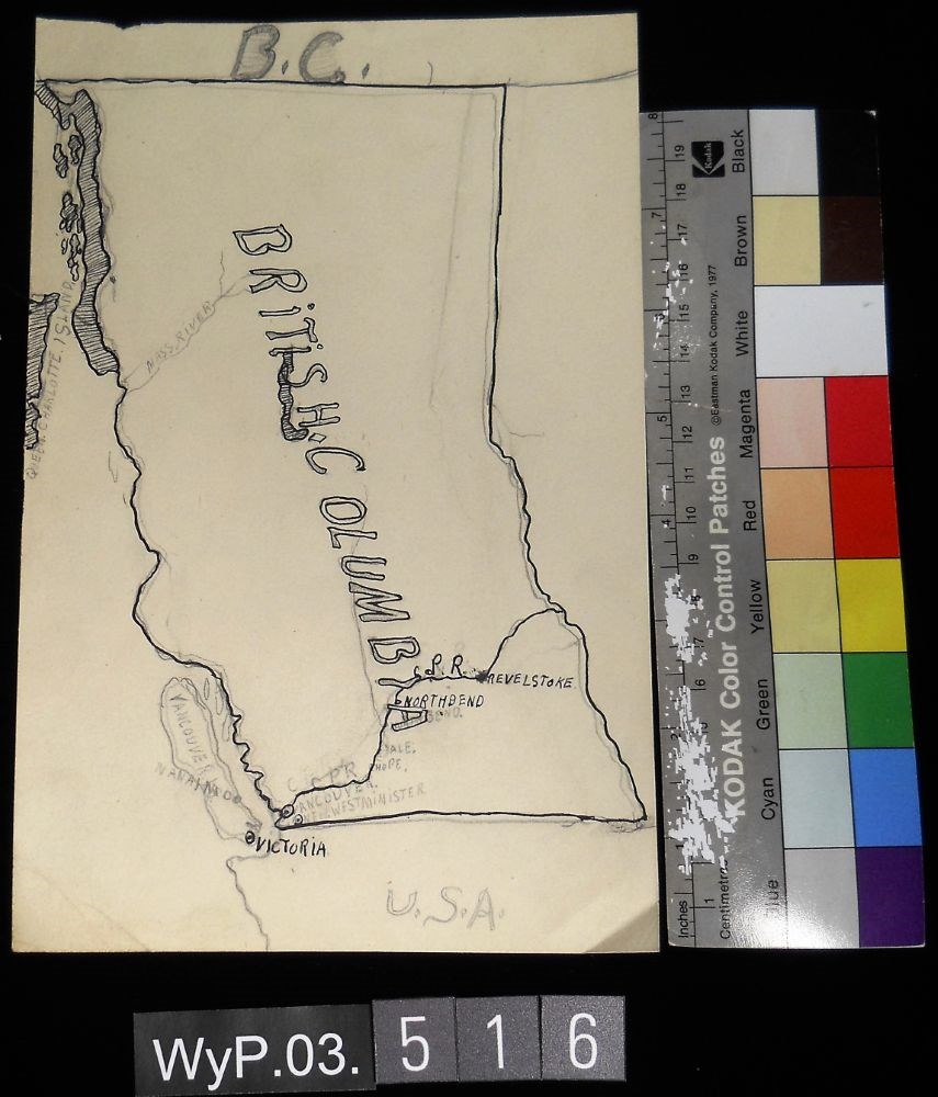
- Date
- 1917 – 1966
- Medium
- graphite; ink on paper
- Catalogue Number
- WyP.03.516
- Description
- A pencil and ink drawing of a map of British Columbia. Notable is Highway 1 and the significant places through which it passes.
1 image
- Title
- B.C.
- Date
- 1917 – 1966
- Medium
- graphite; ink on paper
- Dimensions
- 22.5 x 15.1 cm
- Description
- A pencil and ink drawing of a map of British Columbia. Notable is Highway 1 and the significant places through which it passes.
- Credit
- Gift of Catharine Robb Whyte, O. C., Banff, 1975
- Catalogue Number
- WyP.03.516
Images
This material is presented as originally created; it may contain outdated cultural descriptions and
potentially offensive content.
Read more.
Brochure production
https://archives.whyte.org/en/permalink/descriptions54929
- Scope & Content
- File consists of notes, clippings and drafts of brochures to be published by the Trail Riders of the Canadian Rockies. File also includes several illustrations of trail maps to be included in brochures, correspondence pertaining to brochure production, model release forms and three duplicate b&w pr…
- Date Range
- 1980-1985
- Reference Code
- M545 / V / 29 & 30
- Description Level
- 5 / File
- GMD
- Textual record
- Published record
- Organization record
- Description Level
- 5 / File
- Fonds Number
- M545 / V635
- Series
- M545 / V : Administrative records
- Sous-Fonds
- M545
- Accession Number
- 5939
- Reference Code
- M545 / V / 29 & 30
- Date Range
- 1980-1985
- Physical Description
- 2.5 cm of textual records (21.5 x 28 cm or smaller) -- 3 photographs : b&w prints ; 9 x 9 cm
- Scope & Content
- File consists of notes, clippings and drafts of brochures to be published by the Trail Riders of the Canadian Rockies. File also includes several illustrations of trail maps to be included in brochures, correspondence pertaining to brochure production, model release forms and three duplicate b&w prints depicting several trail riders on horseback [image used in 1980 brochure].
- Notes
- Six "Holiday on Horseback" brochures removed from file. Items are duplicates of brochures processed in series M545 / II and will be offered for return to Trail Riders of the Canadian Rockies.
- File contents organized by date and stored in two folders [see "Content Details"]
- Subject Access
- Administration
- Advertising
- Tourism
- Travel
- Organizations
- Membership
- Businesses
- Geography
- Horse packing
- Horseback riding
- Trails
- Hotels
- Geographic Access
- Canada
- Alberta
- Calgary
- Banff
- Language
- English
- Conservation
- Prints placed in mylar and stored in folder with related textual material to preserve context
- Category
- Exploration, discovery and travel
- Sports, recreation and leisure
- Communications
- Commerce and industry
- Title Source
- Title based on contents of file
- Processing Status
- Processed
This material is presented as originally created; it may contain outdated cultural descriptions and
potentially offensive content.
Read more.
Canada's Great Highway and The Rockies of Canada
https://archives.whyte.org/en/permalink/descriptions54158
- Part Of
- Nicholas Morant fonds
- Scope & Content
- File consists of 2 published books. Contains 1 copy of 'Canada's Great Highway: from the First Stake to the Last Spike' by J.H.E. Secretan (1924), annotated by Nicholas Morant; and 1 copy of 'The Rockies of Canada' by Walter D. Wilcox (1909) with topographical map of the Rocky Mountain region in ba…
- Date Range
- 1909
- 1924
- Reference Code
- M300 / III / D / 5 / 46 to 47
- Description Level
- 5 / File
- GMD
- Textual record
- Published record
- Map
- Part Of
- Nicholas Morant fonds
- Description Level
- 5 / File
- Fonds Number
- M300 / S20 / V500
- Sous-Fonds
- M300
- Sub-Series
- M300 / III / D / 5 : Personal Interest and Gifts
- Accession Number
- 7784
- Reference Code
- M300 / III / D / 5 / 46 to 47
- Responsibility
- Produced by J.H.E. Secretan and Walter D. Wilcox
- Date Range
- 1909
- 1924
- Physical Description
- 2 Textual records: books
- Scope & Content
- File consists of 2 published books. Contains 1 copy of 'Canada's Great Highway: from the First Stake to the Last Spike' by J.H.E. Secretan (1924), annotated by Nicholas Morant; and 1 copy of 'The Rockies of Canada' by Walter D. Wilcox (1909) with topographical map of the Rocky Mountain region in back pocket.
- Storage Range
- In file box M300 / III / D / 5 / 46 to M300 / III / D / 5 / 47.
- Geographic Access
- Canada
- Canadian Rocky Mountains
- Access Restrictions
- Items in this file are not to be accessed or distributed without the explicit permission of their identified copyright owners.
- Reproduction Restrictions
- Items in this file are not to be reproduced without the explicit permission of their identified copyright owners.
- Language
- English
- Conservation
- Items in this file with risky materials attached, such as adhesives, must be covered with an acid-free paper barrier to protect adjacent items.
- Creator
- Nicholas Morant
- Title Source
- Title based on contents of file
- Processing Status
- Processed
This material is presented as originally created; it may contain outdated cultural descriptions and
potentially offensive content.
Read more.
Canadian history and tourism publications
https://archives.whyte.org/en/permalink/descriptions55109
- Part Of
- Luxton family fonds
- Scope & Content
- File consists of published materials pertaining to topics of Canadian, provincial and regional history, related statistical information, and national politics; information booklets and guides for Banff National Park, Alberta, Victoria, B.C., and other regions within Canada; and other Canadian trave…
- Date Range
- 1902-1905
- 1919
- 1928
- 1930-1931
- 1934
- 1940-1941
- 1948
- 1951
- 1955-1957
- 1960
- 1963
- 1979
- 1988
- Reference Code
- LUX / II / F1 / 63 to 64
- Description Level
- 5 / File
- GMD
- Textual record
- Published record
- Part Of
- Luxton family fonds
- Description Level
- 5 / File
- Fonds Number
- LUX
- Series
- LUX / II / F : Collected material
- Sous-Fonds
- LUX / II : Eleanor Luxton sous-fonds
- Sub-Series
- LUX / II / F1 : Textual
- Accession Number
- LUX
- Reference Code
- LUX / II / F1 / 63 to 64
- Date Range
- 1902-1905
- 1919
- 1928
- 1930-1931
- 1934
- 1940-1941
- 1948
- 1951
- 1955-1957
- 1960
- 1963
- 1979
- 1988
- Physical Description
- 4.5 cm of textual records
- Scope & Content
- File consists of published materials pertaining to topics of Canadian, provincial and regional history, related statistical information, and national politics; information booklets and guides for Banff National Park, Alberta, Victoria, B.C., and other regions within Canada; and other Canadian travel and promotional material.
- Notes
- Some items are annotated
- Subject Access
- Advertising
- Travel
- Tourism
- Transportation
- History
- Geography
- Geographic Access
- Canada
- Alberta
- Banff
- Banff National Park
- British Columbia
- Victoria
- Saskatchewan
- Language
- English
- Category
- Commerce and industry
- Exploration, discovery and travel
- Government
- Natural resources
- Politics
- Sports, recreation and leisure
- Transportation
- Title Source
- Title based on contents of file
- Content Details
- File stored in two folders arranged by subject: LUX / II / F1 / 63 : Canadian history and research material LUX / II / F1 / 64 : Canadian tourism publications
- Processing Status
- Processed
This material is presented as originally created; it may contain outdated cultural descriptions and
potentially offensive content.
Read more.