Narrow Results By
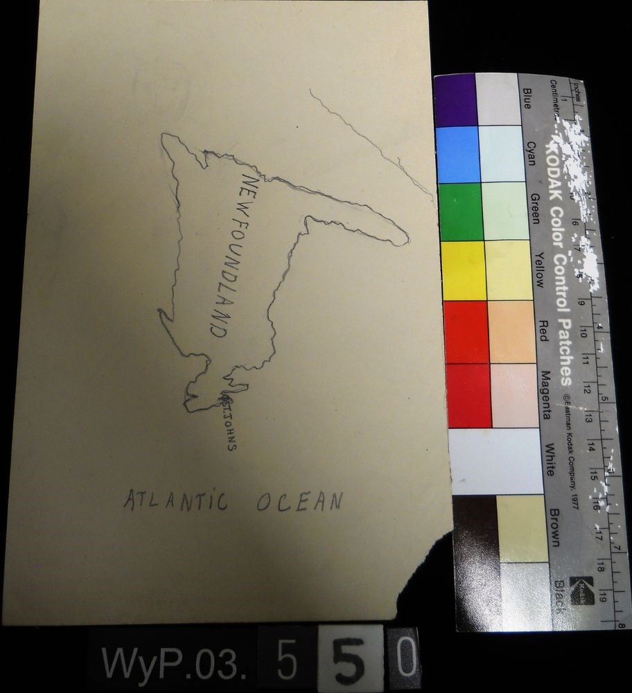
Map of Newfoundland
https://archives.whyte.org/en/permalink/artifactwyp.03.550
- Date
- n.d.
- Medium
- graphite on paper
- Catalogue Number
- WyP.03.550
- Description
- A pencil drawn map of Newfoundland, including the Atlantic Ocean.
1 image
- Title
- Map of Newfoundland
- Date
- n.d.
- Medium
- graphite on paper
- Dimensions
- 22.5 x 15.1 cm
- Description
- A pencil drawn map of Newfoundland, including the Atlantic Ocean.
- Subject
- map
- cartography
- Newfoundland
- Atlantic Ocean
- Credit
- Gift of Catharine Robb Whyte, O. C., Banff, 1979
- Catalogue Number
- WyP.03.550
Images
This material is presented as originally created; it may contain outdated cultural descriptions and
potentially offensive content.
Read more.
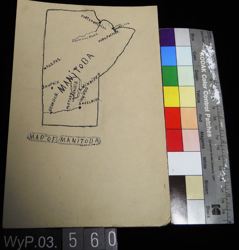
Map of Manitoba
https://archives.whyte.org/en/permalink/artifactwyp.03.560
- Date
- 1917 – 1929
- Medium
- ink; graphite on paper
- Catalogue Number
- WyP.03.560
- Description
- Pencil and ink drawing of a map of Manitoba with rivers, lakes and urban centres labeled. [Below drawing, surrounded by circle of short marks] MAP of MANITOBA
1 image
- Title
- Map of Manitoba
- Date
- 1917 – 1929
- Medium
- ink; graphite on paper
- Dimensions
- 22.5 x 15.1 cm
- Description
- Pencil and ink drawing of a map of Manitoba with rivers, lakes and urban centres labeled. [Below drawing, surrounded by circle of short marks] MAP of MANITOBA
- Credit
- Gift of Catharine Robb Whyte, O. C., Banff, 1979
- Catalogue Number
- WyP.03.560
Images
This material is presented as originally created; it may contain outdated cultural descriptions and
potentially offensive content.
Read more.
Torpedo Car [on verso]
https://archives.whyte.org/en/permalink/artifactwyp.03.563
- Date
- 1917 – 1929
- Medium
- graphite on paper
- Catalogue Number
- WyP.03.563
- Description
- Drawings on both sides of the paper. Side 1 is a pencil drawing of a map of North America, including CANADA, US and MEXiCO all labeled.Verso is a pencil drawing of two figures in a car, facing left. Dust at tires and streak lines suggest speed. Titled in tlc as TORPEDO CAR
1 image
- Title
- Torpedo Car [on verso]
- Date
- 1917 – 1929
- Medium
- graphite on paper
- Dimensions
- 22.5 x 15.1 cm
- Description
- Drawings on both sides of the paper. Side 1 is a pencil drawing of a map of North America, including CANADA, US and MEXiCO all labeled.Verso is a pencil drawing of two figures in a car, facing left. Dust at tires and streak lines suggest speed. Titled in tlc as TORPEDO CAR
- Credit
- Gift of Catharine Robb Whyte, O. C., Banff, 1979
- Catalogue Number
- WyP.03.563
Images

This material is presented as originally created; it may contain outdated cultural descriptions and
potentially offensive content.
Read more.
- Date
- 1917 – 1929
- Medium
- graphite on paper
- Catalogue Number
- WyP.03.581
- Description
- An incomplete pencil drawing of what appears to be a cartographical view of a coastline. The drawing is comprised of a line that wavers extensively and ends abruptly. Line occupies the top third of the paper.
1 image
- Title
- Untitled
- Date
- 1917 – 1929
- Medium
- graphite on paper
- Dimensions
- 22.5 x 15.1 cm
- Description
- An incomplete pencil drawing of what appears to be a cartographical view of a coastline. The drawing is comprised of a line that wavers extensively and ends abruptly. Line occupies the top third of the paper.
- Credit
- Gift of Catharine Robb Whyte, O. C., Banff, 1979
- Catalogue Number
- WyP.03.581
Images

This material is presented as originally created; it may contain outdated cultural descriptions and
potentially offensive content.
Read more.
- Date
- 1917 – 1929
- Medium
- graphite on paper
- Catalogue Number
- WyP.03.583
- Description
- A pencil drawing of the outline of the South American continent. Drawing occupies entire paper.
1 image
- Title
- Untitled
- Date
- 1917 – 1929
- Medium
- graphite on paper
- Dimensions
- 22.5 x 15.1 cm
- Description
- A pencil drawing of the outline of the South American continent. Drawing occupies entire paper.
- Subject
- South America
- map
- geography
- cartography
- Credit
- Gift of Catharine Robb Whyte, O. C., Banff, 1979
- Catalogue Number
- WyP.03.583
Images

This material is presented as originally created; it may contain outdated cultural descriptions and
potentially offensive content.
Read more.
- Date
- 1914 – 1925
- Medium
- graphite on paper
- Catalogue Number
- WyP.03.658
- Description
- Unfinished pencil drawing of what appears to be a jagged coastline. Drawing appears in tlc of paper. Straight lines run parallel to all edges and intersect at corners to form a frame.
1 image
- Title
- Untitled
- Date
- 1914 – 1925
- Medium
- graphite on paper
- Dimensions
- 22.5 x 15.0 cm
- Description
- Unfinished pencil drawing of what appears to be a jagged coastline. Drawing appears in tlc of paper. Straight lines run parallel to all edges and intersect at corners to form a frame.
- Subject
- map
- cartography
- Credit
- Gift of Catharine Robb Whyte, O. C., Banff, 1979
- Catalogue Number
- WyP.03.658
Images

This material is presented as originally created; it may contain outdated cultural descriptions and
potentially offensive content.
Read more.
- Date
- 1914 – 1925
- Medium
- graphite on paper
- Catalogue Number
- WyP.03.662
- Description
- Pencil drawing of the outline of the Europe. Straight vertical lines run parallel to left and right edges
1 image
- Title
- Untitled
- Date
- 1914 – 1925
- Medium
- graphite on paper
- Dimensions
- 15.0 x 22.5 cm
- Description
- Pencil drawing of the outline of the Europe. Straight vertical lines run parallel to left and right edges
- Credit
- Gift of Catharine Robb Whyte, O. C., Banff, 1979
- Catalogue Number
- WyP.03.662
Images

This material is presented as originally created; it may contain outdated cultural descriptions and
potentially offensive content.
Read more.
- Date
- 1914 – 1966
- Medium
- graphite on paper
- Catalogue Number
- WyP.03.672
- Description
- drawn map on thin paper showing mountains, rivers in green and trails in red from Lake Louise Station to Ptarmigan Lake. Includes temple chalet, Eagle Mtn, Hidden Lake, Silvertip run, Hermans run, lookout.
1 image
- Title
- Untitled
- Date
- 1914 – 1966
- Medium
- graphite on paper
- Dimensions
- 20.5 x 26.0 cm
- Description
- drawn map on thin paper showing mountains, rivers in green and trails in red from Lake Louise Station to Ptarmigan Lake. Includes temple chalet, Eagle Mtn, Hidden Lake, Silvertip run, Hermans run, lookout.
- Subject
- map
- Lake Louise
- Skoki
- Ptarmigan Lake
- Credit
- Gift of Catharine Robb Whyte, O. C., Banff, 1979
- Catalogue Number
- WyP.03.672
Images

This material is presented as originally created; it may contain outdated cultural descriptions and
potentially offensive content.
Read more.