Narrow Results By
- Date
- 1917 – 1966
- Medium
- graphite; ink on paper
- Catalogue Number
- WyP.03.516
- Description
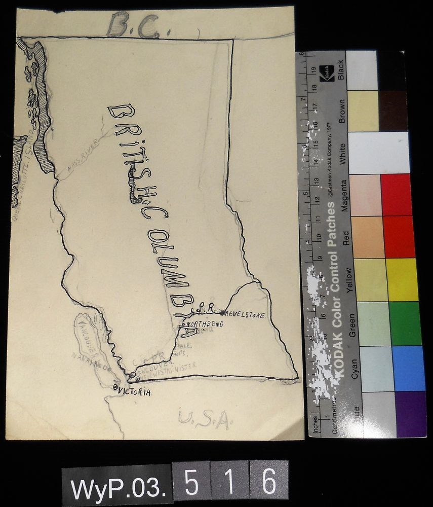
- A pencil and ink drawing of a map of British Columbia. Notable is Highway 1 and the significant places through which it passes.
1 image
- Title
- B.C.
- Date
- 1917 – 1966
- Medium
- graphite; ink on paper
- Dimensions
- 22.5 x 15.1 cm
- Description
- A pencil and ink drawing of a map of British Columbia. Notable is Highway 1 and the significant places through which it passes.
- Credit
- Gift of Catharine Robb Whyte, O. C., Banff, 1975
- Catalogue Number
- WyP.03.516
Images
This material is presented as originally created; it may contain outdated cultural descriptions and
potentially offensive content.
Read more.
Fairy Meadows/Bill Putnam Hut Registers
https://archives.whyte.org/en/permalink/descriptions57650
- Part Of
- Alpine Club of Canada fonds
- Scope & Content
- Sub-series of hut registers from the Bill Putnam / Fairy Meadows Hut produced by the Alpine Club of Canada between 1983 and 2016. Registers include entries from visitors to the huts which pertain to individuals' hiking and climbing trips; details of specific events which occurred while staying at t…
- Date Range
- 1983-2016
- Reference Code
- M200 / IV / M
- Description Level
- 4 / Sub-series
- GMD
- Textual record
- Organization record
- Part Of
- Alpine Club of Canada fonds
- Description Level
- 4 / Sub-series
- Fonds Number
- M200
- V14
- S6
- Series
- M200 / IV: Hut Registers
- Sous-Fonds
- M200
- Sub-Series
- M200 / IV / M: Fairy Meadows/Bill Putnam Hut Registers
- Accession Number
- accn. 2014.8293
- accn. 2023.20
- accn. 8002
- accn. 5635
- accn. 6766
- accn. 2023.10
- accn. 7779
- Reference Code
- M200 / IV / M
- Responsibility
- Registers produced by Alpine Club of Canada
- Date Range
- 1983-2016
- Physical Description
- 20 cm of textual records 8 volumes
- History / Biographical
- According to the Alpine Club of Canada's website: "Built in 1965 by the ACC as a project proposed and largely overseen by William Putnam, the hut has since seen extensive renovations which have transformed the two-storey wooden building into a deluxe backcountry destination. With a complete propane system which includes an oven for baking, a very efficient wood stove and a fully stocked cooking area, comfort is guaranteed. There is sleeping space for 20 on the second level and a spacious common room with adequate space for hanging gear. A large and very hot wood-burning sauna is an absolute treat on those clear, cold winter nights! [...] Fairy Meadow is one of the great backcountry ski destinations in North America, with outstanding ski mountaineering and ski touring. In summer the hut is a base for excellent granite mountaineering. The hut is well equipped with a wood sauna, extensive kitchen and bunks. Access is via Helicopter or a very long and very difficult hike (hiking is absolutely not recommended). The Great Cairn Hut is a day’s mountaineering travel to the south." The ACC's Backcountry Huts: Bill Putnam (Fairy Meadows) Info Sheet states: "In 1965, the Fairy Meadow Hut was constructed by the Alpine Club of Canada as a project proposed and overseen by Bill Putnam. In 1973 the first structure, which was woefully inadequate for the heavy snowfall of the area, was totally renovated and enlarged, a project once again largely funded and overseen by Bill Putnam. Bill Putnam devoted his life to the mountains. He was the President of the American Alpine Club for years and was on their Board of Directors for decades. Putnam has also contributed heavily to Canadian mountaineering history. He spent half a lifetime exploring the Selkirks, Purcells and Rocky Mountains, and took part in writing guidebooks for the same areas (Rocky Mountains of Canada – South and North, Columbia Mountains of Canada – Central, and West and South). In addition to these, he has written several history books about the same mountains. The hut is regularly used in the winter months for ski camps, both by the national Club as well as by various Club sections. The Club’s General Mountaineering Camp, although not utilizing the hut itself, has been held in the Fairy Meadow area on three separate occasions since 1981. The hut renovations in the summer on 1992 included complete gutting and refurbishing of the interior, new outhouses and the addition of a propane stove. The hut is presently in excellent condition".
- Scope & Content
- Sub-series of hut registers from the Bill Putnam / Fairy Meadows Hut produced by the Alpine Club of Canada between 1983 and 2016. Registers include entries from visitors to the huts which pertain to individuals' hiking and climbing trips; details of specific events which occurred while staying at the hut, wildlife sightings, custodial issues and updates, and related topics. The sub-series is separated into individual hut registers, arranged by date:
- M200 / IV / M / 1: Fairy Meadow's Hut Registration 1983 to 1988
- M200 / IV / M / 2: [Fairy Meadows Hut Register 1989 - 1994]
- M200 / IV / M / 3: Fairy Meadow Hut register Apr. 2, 1994 - Aug. 25, 1997
- M200 / IV / M / 4: Fairy Meadow Hut [1997-2001]
- M200 / IV / M / 5: Fairy Meadows March 10, 2001 - May 23, 2003 (Bill Putnam)
- M200 / IV / M / 6: Bill Putnam Hut Register 2003 -2007 [Formerly Fairy Meadow Hut]
- M200 / IV / M / 7: 2007 - 2010 Fairy Meadows Hut Register
- M200 / IV / M / 8: Bill Putnam (Fairy Meadow) Hut Registry
- Name Access
- Alpine Club of Canada
- Subject Access
- Environment
- Environment and Nature
- Alpine Club of Canada
- Backpacking
- Backcountry skiing
- British Columbia
- Revelstoke
- Huts
- Cabins
- Cabins and shelters
- Buildings
- Buildings and facilities
- Camps
- Construction
- Geographic Access
- Canada
- British Columbia
- Selkirks
- Revelstoke
- Access Restrictions
- Restrictions may apply
- Language
- English
- French
- German
- Japanese
- Spanish
- Conservation
- Some registers contain loose pages. Some book/register bindings are fraying.
- Biographical Source Notes
- Alpine Club of Canada website: https://www.alpineclubofcanada.ca/bill-putnam-fairy-meadow-hut/ Alpine Club of Canada Backcountry Huts: Bill Putnam (Fairy Meadows) Info Sheet: https://www.alpineclubofcanada.ca/wp-content/uploads/2023/04/FMHut-InfoSheet.pdf
- Title Source
- Title based on contents of sub-series
- Processing Status
- Processed
This material is presented as originally created; it may contain outdated cultural descriptions and
potentially offensive content.
Read more.
Glacier and Mount Revelstoke National parks: where rivers are born
https://archives.whyte.org/en/permalink/catalogue19860
- Medium
- Library - Book (including soft-cover and pamphlets)
- Published Date
- 1965
- Author
- Baird, David M.
- Publisher
- Ottawa, Geological survey of Canada, Dept. of mines and technical surveys
- Call Number
- 13.115 B11g Pam
- Author
- Baird, David M.
- Responsibility
- David M. Baird
- Publisher
- Ottawa, Geological survey of Canada, Dept. of mines and technical surveys
- Published Date
- 1965
- Physical Description
- v, 104 pages illustrations, maps (1 folded color). 18 cm.
- Subjects
- Geology
- Geology - British Columbia
- Mount Revelstoke National Park
- Glacier National Park
- British Columbia
- Banff National Park
- Abstract
- Pertains to the geology of Glacier and Mount Revelstoke National parks. While providing an overview of the geology, the author also provides the reader with specific details making the experience well rounded. The content pertains to the Rocky Mountains and makes specific mention to Banff and Banff National park
- Contents
- Introduction
- Divides
- Boundaries of the parks
- Origin of the mountains
- The rocks
- The sculpturing of the mountains
- Regional differences in the mountains
- Shapes of mountains
- Roadlog and points of interest along the Trans-Canada Highway
- Epilogue
- Index
- Notes
- The page numbers for the following locations listed in the abstract are as follows; Banff (37), Banff National Park (vi, 4, 19, 37 and 40)
- Accession Number
- 2017.8683
- Call Number
- 13.115 B11g Pam
- Collection
- Archives Library
This material is presented as originally created; it may contain outdated cultural descriptions and
potentially offensive content.
Read more.
The Golden Range, Revelstoke, BC
https://archives.whyte.org/en/permalink/artifactwbg.04.022
- Date
- 1962
- Medium
- ink on paper
- Catalogue Number
- WbG.04.022
- Description
- Foothills area makes up foreground of this mountain scene. Large rounded rocks poke up through the olive green ground. Several stands of trees are scattered across this area. Beyond the trees are craggy mountain peaks. Between the mountains and the trees, there appears to be a patch of mist tha…
- Title
- The Golden Range, Revelstoke, BC
- Date
- 1962
- Medium
- ink on paper
- Dimensions
- 33.9 x 40.7 cm
- Description
- Foothills area makes up foreground of this mountain scene. Large rounded rocks poke up through the olive green ground. Several stands of trees are scattered across this area. Beyond the trees are craggy mountain peaks. Between the mountains and the trees, there appears to be a patch of mist that runs across the print. The sky is soft blue at the top of the print and gets lighter as it moves towards the mountain tops.
- Credit
- Gift of Peter and Judith Jekill, Calgary, 2003
- Catalogue Number
- WbG.04.022
This material is presented as originally created; it may contain outdated cultural descriptions and
potentially offensive content.
Read more.
[Revelstoke 82L/NE, B.C.]
https://archives.whyte.org/en/permalink/catalogue23994
- Medium
- Library - Maps and blueprints (unannotated; published)
- Map
- Published Date
- 1965
- Publisher
- Dept. of Lands and Forests & Water Resources
- Call Number
- NTS
- 82L/NE
- Publisher
- Dept. of Lands and Forests & Water Resources
- Published Date
- 1965
- Physical Description
- 1 map : col
- Scale
- Scale: 1:126,720
- Relief: Contour Interval 100 ft.
- Subjects
- Revelstoke
- British Columbia
- Notes
- National Topographic System
- Accession Number
- 3000
- Call Number
- NTS
- 82L/NE
- Collection
- Archives Library
This material is presented as originally created; it may contain outdated cultural descriptions and
potentially offensive content.
Read more.