Narrow Results By
On the trail of a horse thief
https://archives.whyte.org/en/permalink/catalogue15351
- Medium
- Library - Periodical
- Published Date
- 1919
- Author
- Gleason, Herbert W.
- Publisher
- In National Geographic Vol. 35, No. 4, April 1919
- Call Number
- P
- Author
- Gleason, Herbert W.
- Publisher
- In National Geographic Vol. 35, No. 4, April 1919
- Published Date
- 1919
- Physical Description
- p.349-358
- Medium
- Library - Periodical
- Subjects
- Columbia River
- Windermere
- Call Number
- P
- Collection
- Archives Library
This material is presented as originally created; it may contain outdated cultural descriptions and
potentially offensive content.
Read more.
On the headwaters of Peace River : a narrative of a thousand-mile canoe trip to a little-known range of the Canadian Rockies
https://archives.whyte.org/en/permalink/catalogue3915
- Medium
- Library - Book (including soft-cover and pamphlets)
- Published Date
- 1917
- Author
- Haworth, Paul Leland
- Publisher
- New York : Scribner
- Call Number
- 02.6 H31
- Author
- Haworth, Paul Leland
- Publisher
- New York : Scribner
- Published Date
- 1917
- Physical Description
- 295p. : ill., maps
- Subjects
- British Columbia
- Finlay River
- Accession Number
- 400
- Call Number
- 02.6 H31
- Collection
- Archives Library
This material is presented as originally created; it may contain outdated cultural descriptions and
potentially offensive content.
Read more.
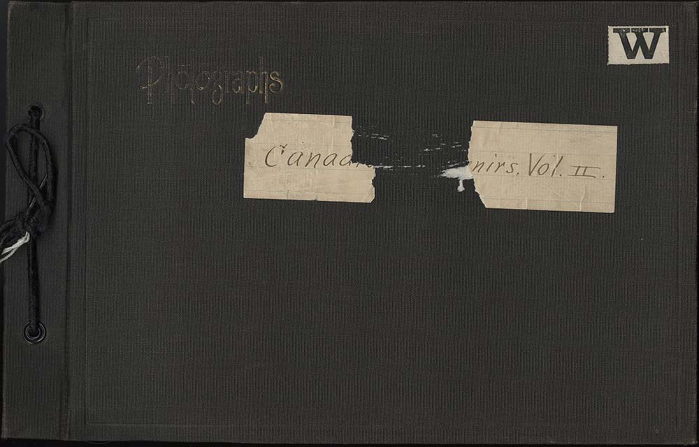
Canadian Souvenirs Vol. II Album
https://archives.whyte.org/en/permalink/descriptions57682
- Part Of
- Alpine Club of Canada fonds
- Scope & Content
- Item consists of 1 photograph album compiled by Frank W. Freeborn of New York City for the Alpine Club of Canada. The album pertains to a 1917 ACC trip throughout the Rocky Mountains in British Columbia, including the Field, Lake O'Hara, Assiniboine, and Glacier areas, and includes black and white …
- Date Range
- 1917
- Reference Code
- V14 / AC 55P / PD - 10
- Description Level
- 6 / Item
- GMD
- Album
- Photograph
1 image
1 Electronic Resource
- Part Of
- Alpine Club of Canada fonds
- Description Level
- 6 / Item
- Fonds Number
- M200 / S6 / V14
- Series
- IV.B. Other material: photographic
- Sous-Fonds
- V14
- Accession Number
- 5200
- Reference Code
- V14 / AC 55P / PD - 10
- GMD
- Album
- Photograph
- Date Range
- 1917
- Physical Description
- 1 album (396 photographs : b&w and col. ; 28.6 x 18.5 cm)
- Scope & Content
- Item consists of 1 photograph album compiled by Frank W. Freeborn of New York City for the Alpine Club of Canada. The album pertains to a 1917 ACC trip throughout the Rocky Mountains in British Columbia, including the Field, Lake O'Hara, Assiniboine, and Glacier areas, and includes black and white photographs, all of which are numbered. A bound-edge flip-book style album, it is tied together with a black string and has a faded gilt "Photographs" embossed in the top left corner of the front cover. Additionally, a small white paper with "W" is adhered to the top right corner and a piece of a lined paper is adhered to the centre with the album's title - this piece is torn through the middle but, as per the title page, the album is titled "Canadian Souvenirs Vol. II."
- Name Access
- Alpine Club of Canada
- Subject Access
- Activities
- Alpine Club of Canada
- Animals
- Backpacking
- Bow Falls
- Bow River
- Bow Valley
- Buildings
- Camps
- Canadian Pacific Railway
- Climbing
- Clothing and dress
- Club
- Environment and Nature
- Glaciers
- Hiking
- Hotels
- Lake O'hara
- Landscapes
- Mountaineering
- Mountaineers
- Mountains
- Period costume
- Photography
- Portrait
- Railways
- Scenery
- scenic
- Trails
- Trains
- Transportation
- Women
- Geographic Access
- Field
- Yoho National Park
- Glacier National Park
- Assiniboine
- Assiniboine Provincial Park
- British Columbia
- Language
- English
- Finding Aid
- Inventory of the Alpine Club of Canada Collection, 1986, provides group or item-level description to this material
- Title Source
- Title based on item
- Processing Status
- Processed
Electronic Resources
Images
This material is presented as originally created; it may contain outdated cultural descriptions and
potentially offensive content.
Read more.
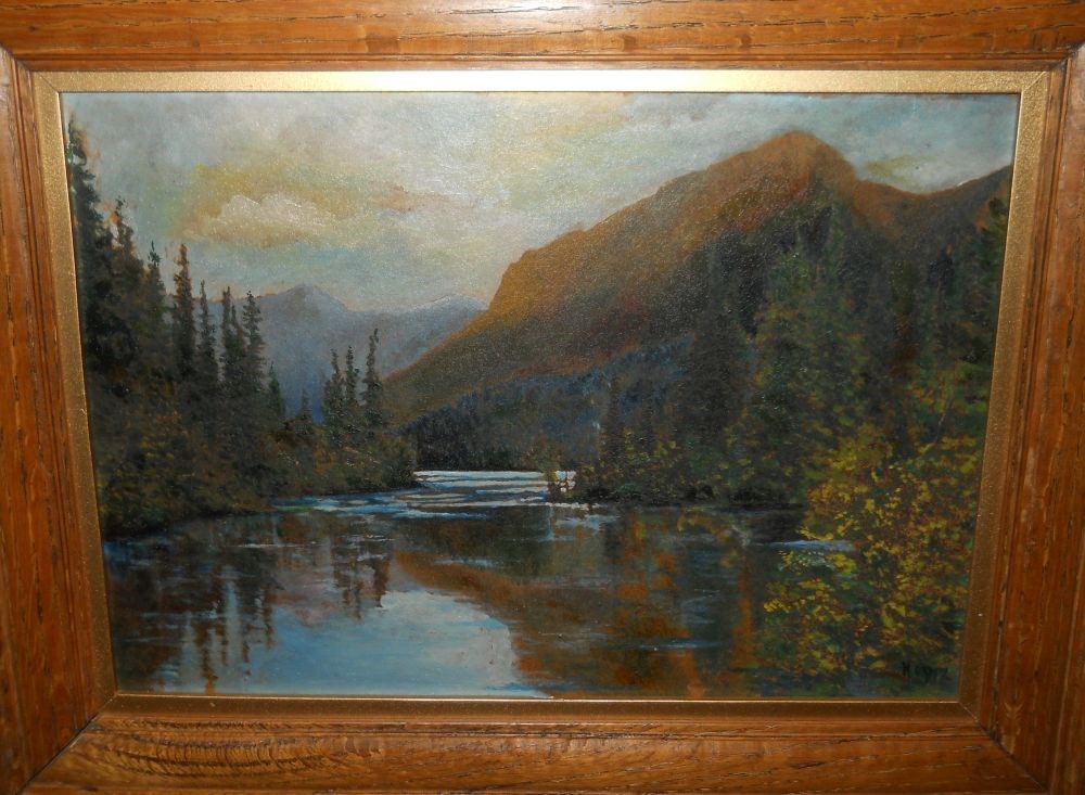
- Date
- 1917
- Medium
- oil on paper board
- Catalogue Number
- HuW.02.05
- Description
- A river covers most of the foreground with reflections of trees and mountains, rapids appear at centre. Evergreen trees and shrubs line the river on both sides. Low mountains in background. The sky is cloudy with tinges of yellow and pink.
1 image
- Title
- Untitled
- Date
- 1917
- Medium
- oil on paper board
- Dimensions
- 24.5 x 34.8 cm
- Description
- A river covers most of the foreground with reflections of trees and mountains, rapids appear at centre. Evergreen trees and shrubs line the river on both sides. Low mountains in background. The sky is cloudy with tinges of yellow and pink.
- Credit
- Gift of Dorothy Hutchinson, Winnipeg, 1994
- Catalogue Number
- HuW.02.05
Images
This material is presented as originally created; it may contain outdated cultural descriptions and
potentially offensive content.
Read more.
Section of region between Yellow Head Pass and Peace River, British Columbia and Alberta, Dominion of Canada
https://archives.whyte.org/en/permalink/catalogue24671
- Medium
- Library - Maps and blueprints (unannotated; published)
- Map
- Published Date
- 1915
- Publisher
- Boston: Richardson & Hale
- Call Number
- C3-9.56
- Publisher
- Boston: Richardson & Hale
- Published Date
- 1915
- Physical Description
- 1 map : b & w
- Scale
- Scale: 1 inch = 10 miles
- Notes
- Compiled from data obtained by S.P. Fay, C.R. Cross, Fred Brewster [on] trips in 1912, 1913, 1914
- Accession Number
- 2933
- Call Number
- C3-9.56
- Collection
- Archives Library
This material is presented as originally created; it may contain outdated cultural descriptions and
potentially offensive content.
Read more.
Alberta : Athabaska sheet
https://archives.whyte.org/en/permalink/catalogue24415
- Medium
- Library - Maps and blueprints (unannotated; published)
- Map
- Published Date
- 1914
- Publisher
- Ottawa: Office of the Surveyor General
- Edition
- 2d ed.
- Call Number
- C9-2.4
- Edition
- 2d ed.
- Publisher
- Ottawa: Office of the Surveyor General
- Published Date
- 1914
- Physical Description
- 1 map
- Scale
- Scale: 1:190,080
- Subjects
- Athabaska River
- Notes
- Sectional map
- Accession Number
- 5576
- 4008
- Call Number
- C9-2.4
- Collection
- Archives Library
This material is presented as originally created; it may contain outdated cultural descriptions and
potentially offensive content.
Read more.
The unexploited West : a compilation of all of the authentic information available . . . as to the natural resources of the unexploited regions of Northern Canada . . .
https://archives.whyte.org/en/permalink/catalogue5716
- Medium
- Library - Book (including soft-cover and pamphlets)
- Published Date
- 1914
- Author
- Chambers, Ernest John
- Publisher
- Ottawa : Dept. of the Interior
- King's Printer
- Call Number
- 03.6 C35
- Author
- Chambers, Ernest John
- Publisher
- Ottawa : Dept. of the Interior
- King's Printer
- Published Date
- 1914
- Physical Description
- xv, 361p. : ill., maps, ports
- Subjects
- Dawson, George Mercer
- Macoun, John
- Peace River
- Notes
- Bibliography
- Accession Number
- 400
- Call Number
- 03.6 C35
- Collection
- Archives Library
This material is presented as originally created; it may contain outdated cultural descriptions and
potentially offensive content.
Read more.
Summary report, 1912
https://archives.whyte.org/en/permalink/catalogue5836
- Medium
- Library - Book (including soft-cover and pamphlets)
- Published Date
- 1914
- Author
- Geological Survey of Canada
- Call Number
- 03.1 G29su 1912
- Author
- Geological Survey of Canada
- Responsibility
- articles by John A. Allan, K.G. Chipman, Reginald Aldworth Daly, B.R. Mackay, S.C. McLean, John D. MacKenzie, Heinrich Ries, Stuart J. Schofield
- Published Date
- 1914
- Physical Description
- p.156-164, 165-176, 221-228, 229-233, 234, 235-246, 418-419, 421-422, 425-436
- Subjects
- Blairmore
- Canadian Pacific Railway
- Flathead
- Kootenay region
- Oldman River
- Purcell Mountains
- Selkirk Mountains
- Windermere
- Accession Number
- 4000
- Call Number
- 03.1 G29su 1912
- Collection
- Archives Library
This material is presented as originally created; it may contain outdated cultural descriptions and
potentially offensive content.
Read more.
Description of surveyed lands in the Railway Belt of British Columbia : Part I: Eastern Division
https://archives.whyte.org/en/permalink/catalogue7371
- Medium
- Library - Book (including soft-cover and pamphlets)
- Published Date
- 1914
- Author
- Canada. Department of the Interior. Topographical Surveys Branch
- Call Number
- 03.7 C16d Pam
- Responsibility
- compiled and edited by S. Maber ...
- Published Date
- 1914
- Physical Description
- 303p. : map
- Subjects
- Columbia River
- Selkirk Mountains
- Call Number
- 03.7 C16d Pam
- Collection
- Archives Library
This material is presented as originally created; it may contain outdated cultural descriptions and
potentially offensive content.
Read more.
Moose Mountain District of the Disturbed Belt, Southern Alberta
https://archives.whyte.org/en/permalink/catalogue23321
- Medium
- Library - Maps and blueprints (unannotated; published)
- Map
- Published Date
- 1914
- Publisher
- G.S.C.
- Call Number
- C5-6.0b
- Publisher
- G.S.C.
- Published Date
- 1914
- Scale
- 2 miles to the inch
- Notes
- (accompanies Bow River Pwer and Storage Investigations by M.C. Hendry 03.6)
- Accession Number
- 576
- Call Number
- C5-6.0b
- Collection
- Archives Library
This material is presented as originally created; it may contain outdated cultural descriptions and
potentially offensive content.
Read more.