Narrow Results By
- Date
- 2023
- Medium
- acrylic on canvas
- Catalogue Number
- ThD.12.01
- Description
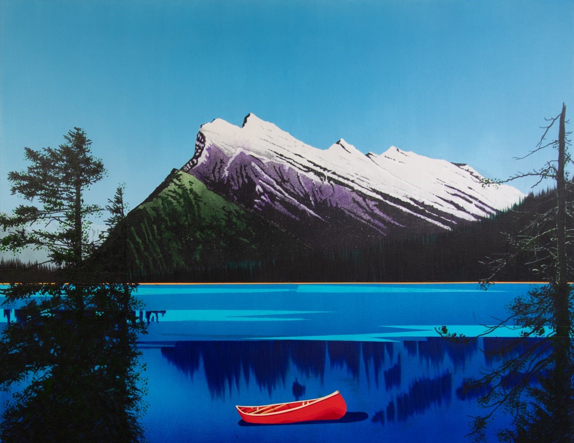
- Landscape painting of a bright red canoe floating on a deep blue lake. Above the lake in the background is a large white and purple mountain [Mt. Rundle], surrounded by trees at the base., The lake is semi-stylized and has a strip of bright orange between the lake and the trees. Large trees rise up…
1 image
- Title
- Autumn Woods
- Date
- 2023
- Medium
- acrylic on canvas
- Dimensions
- 107.0 x 137.0 cm
- Description
- Landscape painting of a bright red canoe floating on a deep blue lake. Above the lake in the background is a large white and purple mountain [Mt. Rundle], surrounded by trees at the base., The lake is semi-stylized and has a strip of bright orange between the lake and the trees. Large trees rise up into the sky at the left and right of the painting.
- Subject
- Banff
- canoe
- Banff National Park
- Credit
- Purchased from Masters Gallery ltd., Calgary, 2023
- Catalogue Number
- ThD.12.01
Images
This material is presented as originally created; it may contain outdated cultural descriptions and
potentially offensive content.
Read more.
Birchbark Canoe
https://archives.whyte.org/en/permalink/artifact106.09.001
- Date
- n.d.
- Material
- birch bark; wood; spruce root
- Catalogue Number
- 106.09.001
- Description
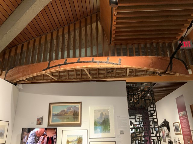
- Birch bark canoe made by hand by Don Gardner out of a contiguous piece of birch bark. Made at his Canmore workshop.
1 image
- Title
- Birchbark Canoe
- Date
- n.d.
- Material
- birch bark; wood; spruce root
- Description
- Birch bark canoe made by hand by Don Gardner out of a contiguous piece of birch bark. Made at his Canmore workshop.
- Subject
- canoe
- hand built
- birch bark
- Credit
- Gift of Grit McCreath, Canmore, 2023
- Catalogue Number
- 106.09.001
Images
This material is presented as originally created; it may contain outdated cultural descriptions and
potentially offensive content.
Read more.
Canada Land Inventory Map
https://archives.whyte.org/en/permalink/catalogue24026
- Medium
- Library - Maps and blueprints (unannotated; published)
- Map
- Published Date
- 1972
- Publisher
- Dept. of Energy, Mines and Resources
- Call Number
- NTS
- 83D
- Publisher
- Dept. of Energy, Mines and Resources
- Published Date
- 1972
- Physical Description
- Colour
- Scale
- 1:250,000
- Subjects
- Canoe River - B.C./Alta.
- Notes
- Land capability for wildlife-Waterfowl
- Accession Number
- 4000
- Call Number
- NTS
- 83D
- Collection
- Archives Library
This material is presented as originally created; it may contain outdated cultural descriptions and
potentially offensive content.
Read more.
[Canoe Mountain]
https://archives.whyte.org/en/permalink/catalogue23537
- Medium
- Library - Maps and blueprints (unannotated; published)
- Map
- Published Date
- 1980
- Publisher
- Dept. of Energy, Mines and Resources
- Edition
- Edition 2
- Call Number
- NTS
- 83D/11
- Edition
- Edition 2
- Publisher
- Dept. of Energy, Mines and Resources
- Published Date
- 1980
- Physical Description
- 1 map : col
- Scale
- Scale: 1:50,000
- Relief: Contour Interval 100 ft.
- Subjects
- Canoe Mountain
- Notes
- National Topographic System
- Accession Number
- 13,000
- Call Number
- NTS
- 83D/11
- Collection
- Archives Library
This material is presented as originally created; it may contain outdated cultural descriptions and
potentially offensive content.
Read more.
[Canoe River]
https://archives.whyte.org/en/permalink/catalogue24025
- Medium
- Library - Maps and blueprints (unannotated; published)
- Map
- Published Date
- 1965
- Publisher
- Dept. of Lands, Forests and Water Resources
- Call Number
- NTS
- 83D
- Publisher
- Dept. of Lands, Forests and Water Resources
- Published Date
- 1965
- Physical Description
- Colour
- Scale
- Scale: 1:50,000
- Relief: Contour Interval 500 feet
- Subjects
- Canoe River
- Notes
- National Topographic System
- Accession Number
- 3000
- 6802
- Call Number
- NTS
- 83D
- Collection
- Archives Library
This material is presented as originally created; it may contain outdated cultural descriptions and
potentially offensive content.
Read more.
[Canoe River 83D, Alta.-B.C.]
https://archives.whyte.org/en/permalink/catalogue24024
- Medium
- Library - Maps and blueprints (unannotated; published)
- Map
- Published Date
- 1963
- Publisher
- Dept. of Mines and Technical Surveys
- Call Number
- NTS
- 83D
- Publisher
- Dept. of Mines and Technical Surveys
- Published Date
- 1963
- Physical Description
- 1 map : col
- Scale
- Scale: 1:250,000
- Relief: Contour Interval 500 ft.
- Subjects
- Canoe River
- Alberta/British Columbia
- Notes
- National Topographic System
- Accession Number
- 1000
- 7030
- Call Number
- NTS
- 83D
- Collection
- Archives Library
This material is presented as originally created; it may contain outdated cultural descriptions and
potentially offensive content.
Read more.
Canoe River 83D Alta./B.C.
https://archives.whyte.org/en/permalink/catalogue23540
- Medium
- Library - Maps and blueprints (unannotated; published)
- Map
- Published Date
- 1986
- Publisher
- Surveys and Mapping Branch, Dept. of Energy, Mines and Resources
- Edition
- 2nd ed.
- Call Number
- NTS
- 83D
- Edition
- 2nd ed.
- Publisher
- Surveys and Mapping Branch, Dept. of Energy, Mines and Resources
- Published Date
- 1986
- Physical Description
- 1 map : col
- Scale
- Scale: 1:250,000
- Relief: Contour interval 500 feet
- Subjects
- Canoe River
- Alberta/British Columbia
- Notes
- National Topographic System
- Accession Number
- 19,000
- Call Number
- NTS
- 83D
- Collection
- Archives Library
This material is presented as originally created; it may contain outdated cultural descriptions and
potentially offensive content.
Read more.
[Canoe River 83D/11 East, B.C.]
https://archives.whyte.org/en/permalink/catalogue23538
- Medium
- Library - Maps and blueprints (unannotated; published)
- Map
- Published Date
- 1962
- Publisher
- Dept. of Mines and Technical Surveys
- Call Number
- NTS
- 83D/11E
- Publisher
- Dept. of Mines and Technical Surveys
- Published Date
- 1962
- Physical Description
- 1 map : col
- Scale
- Scale: 1:50,000
- Relief: Contour interval 100'
- Subjects
- Canoe River
- British Columbia
- Notes
- National Topographic System
- Call Number
- NTS
- 83D/11E
- Collection
- Archives Library
This material is presented as originally created; it may contain outdated cultural descriptions and
potentially offensive content.
Read more.
Canoe River, British Columbia/Alberta
https://archives.whyte.org/en/permalink/catalogue24029
- Medium
- Library - Maps and blueprints (unannotated; published)
- Map
- Published Date
- 1986
- Publisher
- Ottawa : Surveys and Mapping Branch, Dept. of Energy, Mines and Resources
- Edition
- 2d ed.
- Call Number
- NTS
- 83D
- Edition
- 2d ed.
- Publisher
- Ottawa : Surveys and Mapping Branch, Dept. of Energy, Mines and Resources
- Published Date
- 1986
- Physical Description
- 1 map : col
- Scale
- 1:250,000
- Subjects
- Canoe River (B.C./Alta.)
- Accession Number
- 6802
- 27,000
- Call Number
- NTS
- 83D
- Collection
- Archives Library
This material is presented as originally created; it may contain outdated cultural descriptions and
potentially offensive content.
Read more.
Canoe routes in the Sasaginnigak Country, Manitoba
https://archives.whyte.org/en/permalink/catalogue24335
- Medium
- Library - Maps and blueprints (unannotated; published)
- Map
- Publisher
- Manitoba Dept. of Tourism and Recreation Parks Branch
- Call Number
- C6-4.5(a)
- Publisher
- Manitoba Dept. of Tourism and Recreation Parks Branch
- Scale
- 1/2" - 1 mile
- Subjects
- Canoe Manitoba
- Notes
- Canoe Routes, Campsites, Water conditions, Flora, Flauna, Archaeological sites
- Illustrations
- Accession Number
- 2709
- Call Number
- C6-4.5(a)
- Collection
- Archives Library
This material is presented as originally created; it may contain outdated cultural descriptions and
potentially offensive content.
Read more.