Narrow Results By
Burnt Timber Creek 820/11 Alta.
https://archives.whyte.org/en/permalink/catalogue23524
- Medium
- Library - Maps and blueprints (unannotated; published)
- Map
- Published Date
- 1985
- Publisher
- Surveys and Mapping Branch, Dept. of Energy, Mines and Resources
- Edition
- 2nd. ed.
- Call Number
- NTS
- 820/11
- Edition
- 2nd. ed.
- Publisher
- Surveys and Mapping Branch, Dept. of Energy, Mines and Resources
- Published Date
- 1985
- Physical Description
- 1 map : col
- Scale
- Scale: 1:50,000
- Relief: Contour interval 100 feet
- Subjects
- Burnt Timber Creek
- Alberta
- Notes
- National Topographic System
- Accession Number
- 18,500
- Call Number
- NTS
- 820/11
- Collection
- Archives Library
This material is presented as originally created; it may contain outdated cultural descriptions and
potentially offensive content.
Read more.
[Burnt Timber Creek 820/11 East] Alberta
https://archives.whyte.org/en/permalink/catalogue23522
- Medium
- Library - Maps and blueprints (unannotated; published)
- Map
- Published Date
- 1963
- Publisher
- Dept. of Mines and Technical Surveys
- Call Number
- NTS
- 820/11E
- Publisher
- Dept. of Mines and Technical Surveys
- Published Date
- 1963
- Physical Description
- 1 map : col
- Scale
- Scale: 1:50,000
- Relief: Contour interval 100'
- Subjects
- Burnt Timber Creek
- Alberta
- Notes
- National Topographic System
- Accession Number
- 6283
- Call Number
- NTS
- 820/11E
- Collection
- Archives Library
This material is presented as originally created; it may contain outdated cultural descriptions and
potentially offensive content.
Read more.
[Burnt Timber Creek 820/11 West] Alberta
https://archives.whyte.org/en/permalink/catalogue23523
- Medium
- Library - Maps and blueprints (unannotated; published)
- Map
- Published Date
- 1963
- Publisher
- Dept. of Mines and Technical Surveys
- Call Number
- NTS
- 820/11W
- Publisher
- Dept. of Mines and Technical Surveys
- Published Date
- 1963
- Physical Description
- 1 map : col
- Scale
- Scale: 1:50,000
- Relief: Contour interval 100'
- Subjects
- Burnt Timber Creek
- Alberta
- Notes
- National Topographic System
- Accession Number
- 6283
- Call Number
- NTS
- 820/11W
- Collection
- Archives Library
This material is presented as originally created; it may contain outdated cultural descriptions and
potentially offensive content.
Read more.
Burnt Timber Creek, Alberta
https://archives.whyte.org/en/permalink/catalogue23521
- Medium
- Library - Maps and blueprints (unannotated; published)
- Map
- Published Date
- 1996
- Publisher
- Nepean (Ont.) : Canada Map Office
- Edition
- 3d ed.
- Call Number
- NTS
- 820/11
- Edition
- 3d ed.
- Publisher
- Nepean (Ont.) : Canada Map Office
- Published Date
- 1996
- Physical Description
- 1 map : col
- Scale
- Scale: 1:50,000
- Subjects
- Burnt Timber Creek
- Alberta
- Notes
- Information current as of 1994
- Accession Number
- 29,000
- Call Number
- NTS
- 820/11
- Collection
- Archives Library
This material is presented as originally created; it may contain outdated cultural descriptions and
potentially offensive content.
Read more.
- Date
- 1910 – 1925
- Medium
- graphite on paper
- Catalogue Number
- WyP.03.854
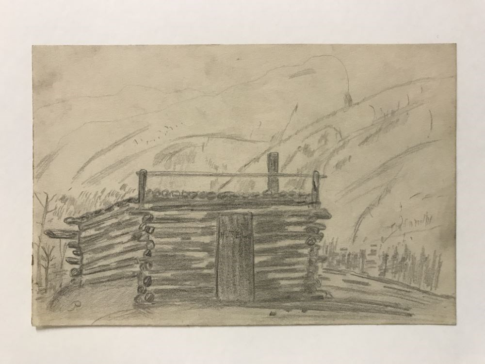
- Description
- A simple square log structure that has trees surrounding it. There are mountains that rise up behind the building. The cabin’s door reads “HOTEL”.
1 image
- Title
- Untitled
- Date
- 1910 – 1925
- Medium
- graphite on paper
- Dimensions
- 15.0 x 22.5 cm
- Description
- A simple square log structure that has trees surrounding it. There are mountains that rise up behind the building. The cabin’s door reads “HOTEL”.
- Credit
- Gift of Catharine Robb Whyte, O. C., Banff, 0
- Catalogue Number
- WyP.03.854
Images
This material is presented as originally created; it may contain outdated cultural descriptions and
potentially offensive content.
Read more.