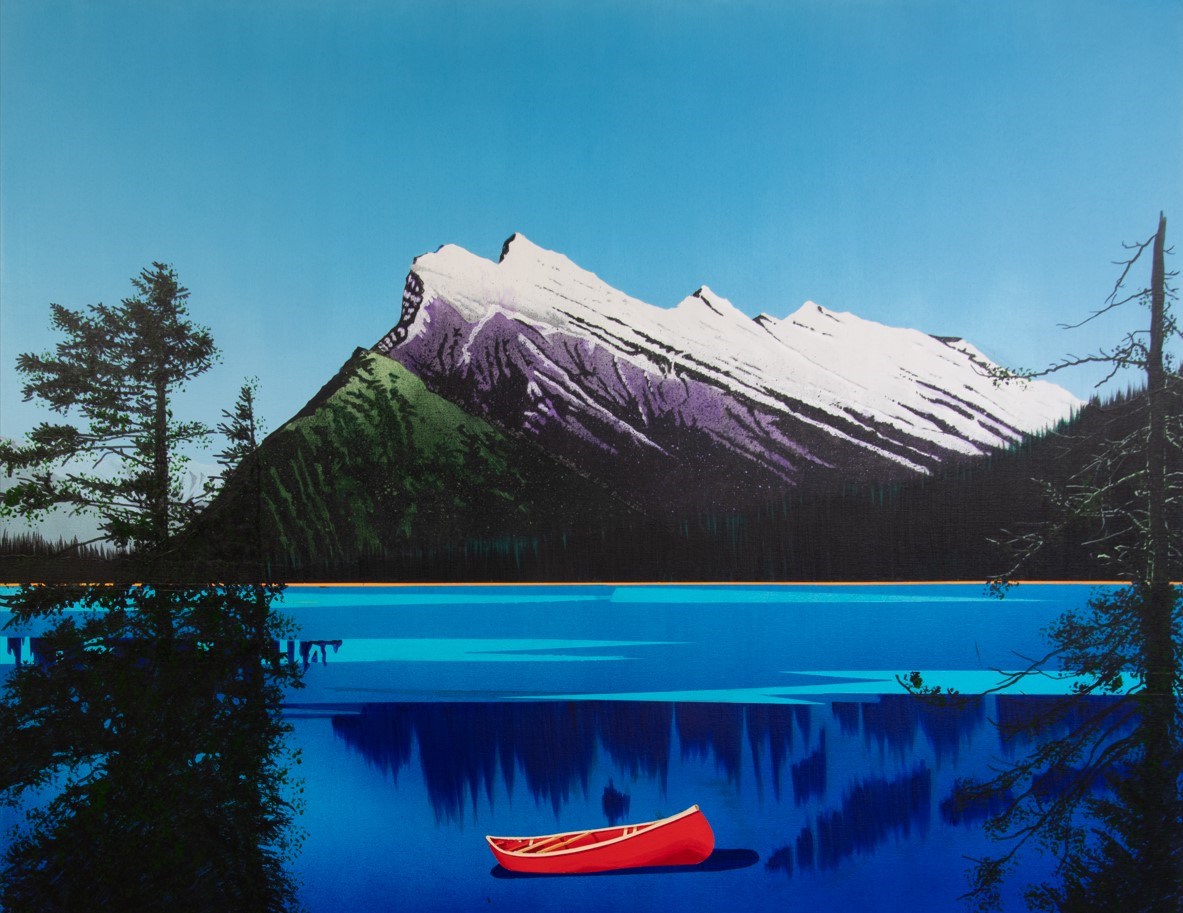
Landscape painting of a bright red canoe floating on a deep blue lake. Above the lake in the background is a large white and purple mountain [Mt. Rundle], surrounded by trees at the base., The lake is semi-stylized and has a strip of bright orange between the lake and the trees. Large trees rise up…
Landscape painting of a bright red canoe floating on a deep blue lake. Above the lake in the background is a large white and purple mountain [Mt. Rundle], surrounded by trees at the base., The lake is semi-stylized and has a strip of bright orange between the lake and the trees. Large trees rise up into the sky at the left and right of the painting.
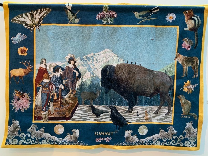
A large woven tapestry featuring a central image of figures in ornate european 17th century clothing on a dias facing a large Bison. Around the Bison are other animals: a mule deer, a raven and crow, a magpie, and a squirrel. 4 other black birds are on the bison’s shoulders and another bird is on i…
A large woven tapestry featuring a central image of figures in ornate european 17th century clothing on a dias facing a large Bison. Around the Bison are other animals: a mule deer, a raven and crow, a magpie, and a squirrel. 4 other black birds are on the bison’s shoulders and another bird is on it’s rump. The ground is a geometric tiled floor and Cascade mountain rises up in the background. In the sky a small helicopter can be seen long lining. This scene is edged in gold thread with a thick blue border full of flora and fauna of the rockies. The bottom two corners have scrollwork, framing “SUMMIT” over a row of pink flowers in bottom centre.
A completely rewritten and expanded edition of the book that started "confessions." Includes detailed descriptions, directions, terrain photos and maps for near-endless options, including everything from playful powder laps to yet to be skied big lines. -- from back cover
Contents
Roadside Runs; Cascade East Face ; Cascade South Face ; Cory Couloir ; Slabatha ; The Goat's Eye ; The Mason's Mistake ; Sunshine Backcountry ; Citadel Pass ; Quartz Hill ; Rock Isle, Larix & Grizzly Lakes ; Twin Cairns ; The Doors ; Wawa Ridge ; Healy Drainage ; Healy Pass ; Bourgeau Meadows ; Lost Horse Creek ; Egypt Lake ; Egypt Lake Access Routes ; Egypt Lake Exit Routes ; Shelter Runs ; The Sphinx ; Scarab Peak ; Pharaoh Peaks ; East Verdant Creek ; Massive Range Mountain ; Pilot & Brett ; Shadow Lake ; Gibbon Pass ; Shadow Valley ; Ball Pass ; Copper Mountain ; Sawback Range ; Cory Pass ; Mystic Pass ; Rockbound Lake ; Traverses
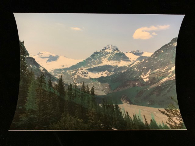
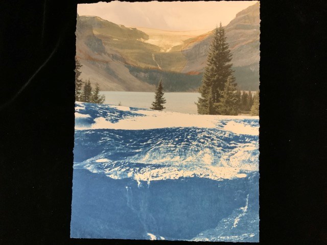
A digital print in which the top half is a full colour image of Bow Lake with trees in front, Bow Glacier Falls, and Bow Glacier sitting atop of rocky ridge in the background. The photograph is overlaid with digital ink drawing of the glacier’s reach in 1902 from an archival photograph. The bottom …
A digital print in which the top half is a full colour image of Bow Lake with trees in front, Bow Glacier Falls, and Bow Glacier sitting atop of rocky ridge in the background. The photograph is overlaid with digital ink drawing of the glacier’s reach in 1902 from an archival photograph. The bottom half of the image is a cyanotype of the glacier in 1902.
This material is presented as originally created; it may contain outdated cultural descriptions and
potentially offensive content.
Read more.
All-time high - an unprecedented number of visitors are heading to Banff National Park, with a million more tourists passing through the gates in just the last five years. Has the beloved park reached its limits?
Through photographs, viewing tips and maps, this books will help you identify 126 peaks that are seen from the highways of Banff National Park. Knowing more about these mountains will make your visit much more reqrding. You'll learn about their naming history and the people, history, geology, and stories connected with each mountain. If you want to get to know your favourites even better, hikes that will lead you to the best trail views are suggested. Read about these outstanding peaks that we see from the highways and then keep the book in your vehicle as a hand reference. -- From back cover
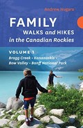
Family Walks and Hikes is an exciting new series of books written specifically for outdoor enthusiasts of all ages and abilities. These accurate, attractive guides feature expertly curated routes, informative maps, and colour photographs.
The first book for the Canadian Rockies in the series brings together an inspiring collection of comfortable walks and spectacular hikes for visitors and locals looking for unique, guided wanderings in a number of diverse locations in the Rockies, including:
Elbow Falls
Powderface Ridge
Troll Falls
Elbow Lake
Grotto Canyon
Grassi Lakes
Tunnel Mountain
Johnston Canyon
Stanley Glacier
Plain Of Six Glaciers
Bow Summit
Ranging from charmingly easy to moderately challenging, these hikes are all accessible from reliable roads and popular staging areas. In addition, each hike is accompanied by a clear, colourful map, step by step directions, and full-colour photographs. Each route includes:
detailed directions to trailheads
colour maps and photographs
seasonal information
round-trip distances
trail commentary
difficulty ratings
(from Rocky Mountain Books website)
The Banff Hot Springs is an iconic location with a long and storied history, having been first found and used by indigenous peoples. In 1883, Canadian Pacific Railway workers found the springs, which led to the development of Banff National Park and tourism in the Canadian Rockies. But the geologic history encompassed in the rocks of the Banff area extends back more than a billion years. In Understanding the Banff Hot Springs through Karst Hydrogeology, Chas Yonge looks at the Banff Hot Spring system from a new perspective: that of karst. Karst landforms are created by dissolution of rock, which leads to some of the most beautiful landscapes on the planet. This karst perspective leads to some very different conclusions regarding the nature of the hot springs. For example: How old is the thermal water? How far has it travlled underground? And how extensive are its pathways? Anyone with an interest in the science behind the Banff Hot Springs and exploring the local geology and landscape of the Canadian Rockies will find this book the perfect answer to their curiousity. Featuring a foreword by Arthur N. Palmer, Professor of Hydrogeology, Emeritus, at State University of New York. As of a few years ago, Chas Yonge was the former owner and operator of Canmore Cave Tours, offering interpretive tours underground. He has been an enthusiastic caver for almost 50 years, taking him all over the world. Since earning a PhD in karst paleoclimatology, he has applied isotope studies to karst, culminating in a number of publications. He has been an adjunct professor at the University of Calgary and is currently a fellow of the Royal Canadian Geographic Society.
(From Amazon website)
Contents
Acknowledgements
Foreward
Hot springs in Canada where do you find them?
Rocky Mountain geology around Banff
Geological setting of the Banff Springs Hotel
Sources and depth of the Banff thermal spring water
Carbonate hot springs viewed as hypogene karst
Hydrogeology of the the Rockies and Banff Hot Springs
Flow nets developed along thurst faults
Conduits developed along a thurst fault, nearby examples in Rats Nest Cave
Hypogene recharge at the Banff Hot Springs: mechanisms and chemistry
Epigene recharge; the invasion of cold, shallow groundwater at Banff
Age of the groundwater
Spring elevation: relevance to the Late Wisconsin Glaciation
A modern backcountry ski guide for day trips in the Kicking Horse Pass area found at the border of Banff and Yoho National Parks. Includes detailed descriptions, directions, terrain photos and maps for everything from tree skiing to no fall glacier descents. -- from back cover