Research Collections
Toggle Full Record
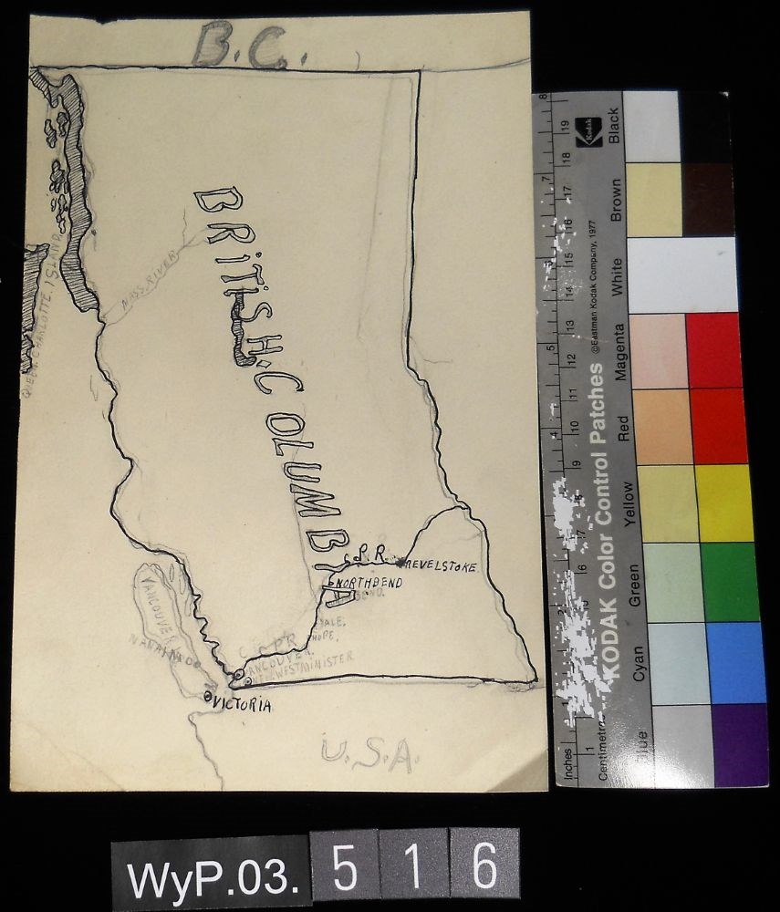
B.C.
https://archives.whyte.org/en/permalink/artifactwyp.03.516
Artist
Peter Whyte (1905 – 1966, Canadian)
Date
1917 – 1966
Medium
graphite; ink on paper
Catalogue Number
WyP.03.516
Description
A pencil and ink drawing of a map of British Columbia. Notable is Highway 1 and the significant places through which it passes.
More detail
1 image
Artist
Peter Whyte (1905 – 1966, Canadian)
Title
B.C.
Date
1917 – 1966
Medium
graphite; ink on paper
Dimensions
22.5 x 15.1 cm
Description
A pencil and ink drawing of a map of British Columbia. Notable is Highway 1 and the significant places through which it passes.
Subject
British Columbia
Highway 1
Revelstoke
Vancouver
Hope
geography
Credit
Gift of Catharine Robb Whyte, O. C., Banff, 1975
Catalogue Number
WyP.03.516
Images
Less detail
Share
Facebook
Twitter
Google Plus
LinkedIn
Permalink
Citation
This material is presented as originally created; it may contain outdated cultural descriptions and potentially offensive content.
Read more.
Toggle Full Record
[Boundary Between Alberta and B.C.]
https://archives.whyte.org/en/permalink/catalogue24662
Medium
Library - Maps and blueprints (unannotated; published)
Map
Published Date
1916
Edition
Sheet #12
Call Number
C3-9.13
More detail
Edition
Sheet #12
Published Date
1916
Scale
Scale: 1:62,500
Relief: Contour interval 100 ft.
Medium
Library - Maps and blueprints (unannotated; published)
Map
Series
Sheet #12
Subjects
Alberta - Boundaries
British Columbia - Boundaries
Notes
2 duplicates in Map Room
2 photostat copies showing outline of Mt. Assiniboine Provincial Park
Duplicate in Boundary Atlas #1
Accession Number
44
400
3349
2949
Call Number
C3-9.13
Collection
Archives Library
Less detail
Share
Facebook
Twitter
Google Plus
LinkedIn
Permalink
This material is presented as originally created; it may contain outdated cultural descriptions and potentially offensive content.
Read more.
Toggle Full Record
[Boundary Between Alberta and B.C.]
https://archives.whyte.org/en/permalink/catalogue24664
Medium
Library - Maps and blueprints (unannotated; published)
Map
Published Date
1916
Call Number
C3-9.15
More detail
Published Date
1916
Scale
Scale: 1:62,500
Relief: Contour interval 100 ft.
Medium
Library - Maps and blueprints (unannotated; published)
Map
Series
Sheet #15
Subjects
Alberta - Boundaries
British Columbia - Boundaries
Notes
Duplicate in Map Room
Duplicate in Boundary Atlas #1
Accession Number
400
Call Number
C3-9.15
Collection
Archives Library
Less detail
Share
Facebook
Twitter
Google Plus
LinkedIn
Permalink
This material is presented as originally created; it may contain outdated cultural descriptions and potentially offensive content.
Read more.
Toggle Full Record
[Boundary Between Alberta and B.C.]
https://archives.whyte.org/en/permalink/catalogue24665
Medium
Library - Maps and blueprints (unannotated; published)
Map
Published Date
1917
Call Number
C3-9.17, -9.18
More detail
Published Date
1917
Scale
Scale: 1:62,500
Relief: Contour interval 100 ft.
Medium
Library - Maps and blueprints (unannotated; published)
Map
Series
Sheet #17, Sheet #18
Subjects
Alberta - Boundaries
British Columbia - Boundaries
Notes
Duplicate in Boundary Atlas #2
Accession Number
718
Call Number
C3-9.17, -9.18
Collection
Archives Library
Less detail
Share
Facebook
Twitter
Google Plus
LinkedIn
Permalink
This material is presented as originally created; it may contain outdated cultural descriptions and potentially offensive content.
Read more.
Toggle Full Record
Boundary between Alberta and British Columbia / Interprovincial Boundary Commission
https://archives.whyte.org/en/permalink/catalogue21452
Medium
Library - Maps and blueprints (unannotated; published)
Map
Published Date
ca. 1915-1917
Publisher
Ottawa : Surveyor General's Office
Call Number
C3-9.1-29b
More detail
Publisher
Ottawa : Surveyor General's Office
Published Date
ca. 1915-1917
Physical Description
25 maps : col
Medium
Library - Maps and blueprints (unannotated; published)
Map
Subjects
Alberta - Boundaries
British Columbia - Boundaries
Notes
In this sequence: 1-3, 5, 6-13A, 15, 17-20, 21, 25, 29, 29B
Accession Number
2949
Call Number
C3-9.1-29b
Collection
Archives Library
Less detail
Share
Facebook
Twitter
Google Plus
LinkedIn
Permalink
This material is presented as originally created; it may contain outdated cultural descriptions and potentially offensive content.
Read more.
Toggle Full Record
[Boundary Between Alta. & B.C.]
https://archives.whyte.org/en/permalink/catalogue24669
Medium
Library - Maps and blueprints (unannotated; published)
Map
Published Date
1917
Call Number
C3-9.29A, -9.29B
More detail
Published Date
1917
Scale
Scale: 1:25,000
Relief: Contour interval 100 ft.
Medium
Library - Maps and blueprints (unannotated; published)
Map
Series
Sheets #29A & 29B
Subjects
Alberta - Boundaries
British Columbia - Boundaries
Notes
Duplicate in Boundary Atlas #3
Call Number
C3-9.29A, -9.29B
Collection
Archives Library
Less detail
Share
Facebook
Twitter
Google Plus
LinkedIn
Permalink
This material is presented as originally created; it may contain outdated cultural descriptions and potentially offensive content.
Read more.
Toggle Full Record
[Boundary Between Alta. and B.C.]
https://archives.whyte.org/en/permalink/catalogue24666
Medium
Library - Maps and blueprints (unannotated; published)
Map
Published Date
1917
Call Number
C3-9.18A
More detail
Published Date
1917
Scale
Scale: 1:25,000
Relief: Contour interval 100 ft.
Medium
Library - Maps and blueprints (unannotated; published)
Map
Series
Sheet #18A
Subjects
Alberta - Boundaries
British Columbia - Boundaries
Notes
Duplicate in Boundary Atlas #2
Accession Number
718
Call Number
C3-9.18A
Collection
Archives Library
Less detail
Share
Facebook
Twitter
Google Plus
LinkedIn
Permalink
This material is presented as originally created; it may contain outdated cultural descriptions and potentially offensive content.
Read more.
Toggle Full Record
[Boundary Between Alta. and B.C.]
https://archives.whyte.org/en/permalink/catalogue24667
Medium
Library - Maps and blueprints (unannotated; published)
Map
Published Date
1918-1919
Call Number
C3-9.10, -9.20, -9.21
More detail
Published Date
1918-1919
Scale
Scale: 1:62,500
Relief: Contour interval 100 ft.
Medium
Library - Maps and blueprints (unannotated; published)
Map
Series
Sheets #19, 20, 21
Subjects
Alberta - Boundaries
British Columbia - Boundaries
Notes
Duplicate of #20
Duplicates in Boundary Atlas #2
Accession Number
718
Call Number
C3-9.10, -9.20, -9.21
Collection
Archives Library
Less detail
Share
Facebook
Twitter
Google Plus
LinkedIn
Permalink
This material is presented as originally created; it may contain outdated cultural descriptions and potentially offensive content.
Read more.
Toggle Full Record
[Boundary Between Alta. and B.C.]
https://archives.whyte.org/en/permalink/catalogue24668
Medium
Library - Maps and blueprints (unannotated; published)
Map
Published Date
1917
Call Number
C3-9.29
More detail
Published Date
1917
Scale
Scale: 1:62,500
Relief: Contour interval 100 ft.
Medium
Library - Maps and blueprints (unannotated; published)
Map
Series
Sheet #29
Subjects
Alberta - Boundaries
British Columbia - Boundaries
Notes
Duplicate in Boundary Atlas #3
Accession Number
718
Call Number
C3-9.29
Collection
Archives Library
Less detail
Share
Facebook
Twitter
Google Plus
LinkedIn
Permalink
This material is presented as originally created; it may contain outdated cultural descriptions and potentially offensive content.
Read more.
Toggle Full Record
Boundary Between Alta. and B.C., Simpson Pass
https://archives.whyte.org/en/permalink/catalogue24663
Medium
Library - Maps and blueprints (unannotated; published)
Map
Published Date
1913
Call Number
C3-9.13A
More detail
Published Date
1913
Scale
Scale: 1:25,000
Relief: Contour interval 100 ft.
Medium
Library - Maps and blueprints (unannotated; published)
Map
Series
Sheet #13A
Subjects
Alberta - Boundaries
British Columbia - Boundaries
Simpson Pass
Notes
Duplicates in Boundary Atlas #1 (2 copies)
Accession Number
2949
Call Number
C3-9.13A
Collection
Archives Library
Less detail
Share
Facebook
Twitter
Google Plus
LinkedIn
Permalink
This material is presented as originally created; it may contain outdated cultural descriptions and potentially offensive content.
Read more.